- Collection:
- New Georgia Encyclopedia
- Title:
- Satilla River Watershed
- Date of Original:
- 1708/2022
- Subject:
- Rivers--Georgia
Land use--Georgia
Land use mapping--Georgia
Satilla River (Ga.)
Watersheds--Georgia
Georgia--Maps - Location:
- United States, Georgia, 32.75042, -83.50018
- Medium:
- land use maps
maps (documents) - Type:
- Still Image
- Format:
- image/jpeg
- Description:
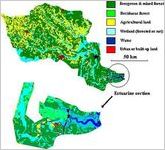
- The Satilla River, one of five blackwater rivers in Georgia, begins in Ben Hill County and lies entirely within the Coastal Plain. It drains to the Atlantic Ocean. Pollution levels are very low in the Satilla, which is bordered by cypress and black gum forests.
This map of the Satilla River watershed in Georgia shows land use and land cover in the Satilla watershed, which lies entirely in the coastal plain. The key on the right indicates the colors used in the map to represent different types of land use and land cover. A detailed image at the bottom gives a closer view of the estuarine section of the Satilla River.
The Satilla River, one of five blackwater rivers in Georgia, begins in Ben Hill County. It drains to the Atlantic Ocean. Pollution levels are very low in the Satilla, which is bordered by cypress and black gum forests. - External Identifiers:
- Metadata URL:
- https://www.georgiaencyclopedia.org/articles/geography-environment/river-basins/m-10418/
- Rights Holder:
- Courtesy of Georgia Rivers LMER
- Additional Rights Information:
- Please contact holding institution for information regarding use and copyright status.
- Original Collection:
- Forms part of: New Georgia Encyclopedia
- Holding Institution:
- New Georgia Encyclopedia (Project)
- Rights:
-
