- Collection:
- New Georgia Encyclopedia
- Title:
- Altamaha River Watershed
- Date of Original:
- 1980/2022
- Subject:
- Rivers--Georgia
Land use--Georgia
Land use mapping--Georgia
Altamaha River (Ga.)
Watersheds--Georgia
Georgia--Maps - Location:
- United States, Georgia, 32.75042, -83.50018
- Medium:
- land use maps
maps (documents) - Type:
- Still Image
- Format:
- image/jpeg
- Description:
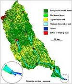
- The Altamaha River, formed by the convergence of the Oconee and Ocmulgee rivers, drains into the Atlantic Ocean at Darien. The Altamaha watershed is the largest in Georgia and the third largest in the United States to drain into the Atlantic.
This map of the Altamaha River watershed in Georgia shows land use and land cover in the Altamaha watershed, which includes lands in the Appalachian foothills, Piedmont, and upper coastal plain. The key on the right indicates the colors used in the map to represent different types of land use and land cover.
The Altamaha River, formed by the convergence of the Oconee and Ocmulgee rivers, drains into the Atlantic Ocean at Darien, Georgia. The Altamaha watershed is the largest in Georgia and the third largest in the United States to drain into the Atlantic. - External Identifiers:
- Metadata URL:
- https://www.georgiaencyclopedia.org/articles/geography-environment/river-basins/m-10417/
- Rights Holder:
- Courtesy of Georgia Rivers LMER
- Additional Rights Information:
- Please contact holding institution for information regarding use and copyright status.
- Original Collection:
- Forms part of: New Georgia Encyclopedia
- Holding Institution:
- New Georgia Encyclopedia (Project)
- Rights:
-
