- Collection:
- McDuffie Museum Collection
- Title:
- Map, Atlanta Campaign, Cobb County, 1864
- Date of Original:
- 1905-02-06
- Subject:
- Widows--Georgia--Cobb County
Atlanta Campaign, 1864
United States--History--Civil War, 1861-1865--Campaigns
United States--History--Civil War, 1861-1865--Secret service
United States--History--Civil War, 1861-1865--Military intelligence--Georgia--Cobb County
United States--History--Civil War, 1861-1865--Maps
United States--History--Civil War, 1861-1865--Women
Schofield, John McAllister, 1831-1906
Kennesaw Mountain, Battle of, Ga., 1864 - Location:
- United States, Georgia, Cobb County, Marietta, 33.9526, -84.54993
United States, Georgia, Cobb County, Powder Springs, 33.85955, -84.68382 - Medium:
- maps (documents)
- Type:
- Still Image
- Format:
- image/jpeg
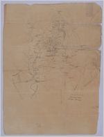
- Description:
- Hand-drawn map of Cobb County south of Marietta, Georgia, created by a Union spy. The map was created for the Army of Ohio under General Schofield as they advanced towards Atlanta after the Battle of Kennesaw Mountain. The points on the map are the homes, plantations and buildings of residents, identified by surnames. "Wid" stands for widow. The square and cross symbols indicate churches, and the wheels and spokes symbols indicate soldier positions. These soldiers are usually positioned next to mills or industry for shelter and protection. The map includes towns, hills, railroads, and rivers, including the Chatahoochee River. [1:63,360]. 1 image.
- External Identifiers:
- Metadata URL:
- https://dlg.galileo.usg.edu/id:mcdm_mcd_mcd0006
- Digital Object URL:
- https://dlg.galileo.usg.edu/mcdm/mcd/do:mcd0006
- Language:
- eng
- Holding Institution:
- McDuffie Museum
- Rights:
-
