- Collection:
- McDuffie Museum Collection
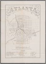
- Title:
- Atlanta : from Vincent's subdivision map, published by the City Council
- Creator:
- United States. Army of the Cumberland. Topographical Engineers Office.
- Date of Original:
- 1864-07-25
- Subject:
- Atlanta (Ga.)--Maps
Atlanta Campaign, 1864
Georgia--History--Civil War, 1861-1865
United States--History--Civil War, 1861-1865--Campaigns
Sherman, William T. (William Tecumseh), 1820-1891 - Location:
- United States, Georgia, Fulton County, Atlanta, 33.749, -84.38798
- Medium:
- maps (documents)
- Type:
- Still Image
- Format:
- image/jpeg
- Description:
- From Vincent's subdivision map of the city of Atlanta, Dekalb County, state of Georgia. Savannah : Edward A. Vincent, 185-. Includes numbered building index. This is the map commissioned for use by General W. T. Sherman in the siege of Atlanta. It is one of the most important of Civil War maps in the its significance to Georgia and the outcome of the war. Scale [1:15, 840]. 1 image.
- External Identifiers:
- Metadata URL:
- https://dlg.galileo.usg.edu/id:mcdm_mcd_mcd0003
- Digital Object URL:
- https://dlg.galileo.usg.edu/mcdm/mcd/do:mcd0003
- Language:
- eng
- Holding Institution:
- McDuffie Museum
- Rights:
-
