- Collection:
- Historic Postcard Collection (Georgia Archives)
- Title:
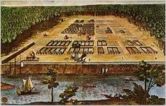
- Map of Savannah, 1734
- Creator:
- Walter H. Miller & Company
- Date of Original:
- 1900/1979
- Subject:
- Savannah (Ga.)--Maps
City planning--Georgia--Savannah
Rivers--Georgia--Savannah
Ships--Georgia--Savannah - Location:
- United States, Georgia, Chatham County, Savannah, 32.08354, -81.09983
- Type:
- Still Image
- Format:
- image/jpeg
- Description:
- Peter Gordon map dated March 29, 1734, showing General Oglethorpe's original plan of the city of Savannah, Georgia, and its now famous squares. Reproduced for Historic Savannah Foundation.
- Metadata URL:
- https://vault.georgiaarchives.org/digital/collection/postcard/id/552
- Additional Rights Information:
- Postcards published after 1923 may be covered by copyright. The Georgia Archives cannot provide permission to publish.
- Extent:
- Visual image
- Original Collection:
- Historic Postcard Collection, RG 48-2-5, Georgia Archives
- Holding Institution:
- Georgia Archives
- Rights:
-
