- Collection:
- County Maps
- Title:
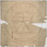
- Jenkins County Map
- Date of Original:
- 1906
- Subject:
- Jenkins County (Ga.)--Maps
- Location:
- United States, Georgia, Jenkins County, 32.79247, -81.96353
- Medium:
- maps (documents)
- Type:
- Still Image
- Format:
- image/jpeg
- Description:
- "The above is a true map of Jenkins County, and gets its area from Burke, Screven, Bulloch, and Emanuel County, containing 362 square miles. Commenced November 27, 1905 and completed June 1, 1906. Surveyed by W. H. Jordan, Surveyor."
- External Identifiers:
- Metadata URL:
- http://vault.georgiaarchives.org/cdm/ref/collection/cmf/id/205
- Language:
- eng
- Extent:
- 23.5 inches x 23.25 inches
- Original Collection:
- County Maps, Surveyor General, RG 3-9-66, Georgia Archives
- Holding Institution:
- Georgia Archives
- Rights:
-
