- Collection:
- County Maps
- Title:
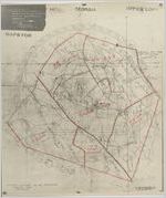
- Candler County Map
- Date of Original:
- 1930
- Subject:
- Candler County (Ga.)--Maps
- Location:
- United States, Georgia, Candler County, 32.40344, -82.07367
- Medium:
- maps (documents)
- Type:
- Still Image
- Format:
- image/jpeg
- Description:
- "Official Map - Adopted by the Board of Education - Showing the school districts, boundaries and lines of said districts in said [county]."Filed June 1, 1936.
- External Identifiers:
- Metadata URL:
- http://vault.georgiaarchives.org/cdm/ref/collection/cmf/id/190
- Language:
- eng
- Extent:
- 18 inches x 21 inches
- Original Collection:
- County Maps, Surveyor General, RG 3-9-66, Georgia Archives
- Holding Institution:
- Georgia Archives
- Rights:
-
