- Collection:
- Georgia Government Publications
- Title:
- Vogel State Park trail map [July 2010]
- Creator:
- Georgia. Department of Natural Resources. Parks, Recreation and Historic Sites Division
- Contributor to Resource:
- Georgia. Department of Natural Resources. Parks, Recreation and Historic Sites Division
- Publisher:
- Atlanta, Ga. : Georgia. Department of Natural Resources. Parks, Recreation and Historic Sites Division
- Date of Original:
- 2010-07
- Subject:
- Georgia
- Location:
- United States, Georgia, 32.75042, -83.50018
- Medium:
- publications (documents)
- Type:
- Text
- Format:
- application/pdf
- Description:
- map
- External Identifiers:
- Call Number GA N200.P2 M1 2010 V6
- Metadata URL:
- https://dlg.galileo.usg.edu/id:dlg_ggpd_s-ga-bn200-pp2-bm1-b2010-bv6-belec-p-btext
- Digital Object URL:
- https://dlg.galileo.usg.edu/do:dlg_ggpd_s-ga-bn200-pp2-bm1-b2010-bv6-belec-p-btext
- Language:
- eng
- Holding Institution:
- University of Georgia. Map and Government Information Library
- Rights:
-

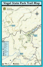
Vogel State Park Trail Map
405 Vogel State Park Road Blairsville, GA 30512 Park: 706-745-2628 Emergency: 706-745-5129 Reservations: 1-800-864-7275 www.gastateparks.org
Coosa Trail (Backcountry)
& Sunrise Grocery
T o 129
4271 ft.
Coosa Tr. Duncan Ridge Tr.
Trail drops into road then, immediately returns to woods on same side.
180
to Suches
LEGEND Hiking Trails
Coosa (Backcountry) Bear Hair Gap Byron Herbert Reese Lake Trahlyta Trahlyta Falls Spur Appalachian Other USFS Trails
Symbols
Paved Roads Service Roads Backcountry Campsite Tent Campsite Shelter RV Campsite Park Office
Trail (Backcountry)
Coosa 4338 ft.
Appalachian Trail
0
1/4 mile
SCALE
1/2 mile
Forest Service Road #108
/ Forest Service Road #107 Coosa Trail
Wolf Creek Road (Backcountry)
Park Boundary
to Blairsville Trahlyta Falls
180
2280 ft.
Spur Trail
Lake Trahlyta
19
180
129
Byron Herbert Reese Trail
Park Boundary
VOGEL STATE PARK
Entrance for Coosa, Bear Hair & Byron Reece Trails start
adjacent to Cottage #7.
Vogel Overlook Bear Hair Tr.
Trail
Bear Hair Gap
Park Boundary
Park Boundary
Coosa Trail Bear Hair Tr.
11 19 129
to Dahlonega
NOTICE: Campfires are not allowed in Blood Mountain Wilderness Area.
4458 ft.
Appalachian Trail
11 19 129
P
WTraadlainsgi-Yi CPoesntter
One of Georgia's oldest and most popular state parks, Vogel is located on land donated by the Vogel Tanning Company. Located near Brasstown Bald, Georgia's tallest mountain, the park surrounds beautiful Lake Trahlyta, which was constructed by the Civilian Conservation Corps (CCC) in the mid-1930's during the initial development of the park.
The park is rich in both history and diversity of the natural resources. Lying in the shadows of Blood and Slaughter Mountains, Indian legends tell of a great battle in which the streams `ran red with blood.' Biologically, one of the richest areas on Earth, this great diversity adds to Vogel's beauty and uniqueness. Ever changing, there is always something new.
Vogel has something for everyone. Visitors can choose from picnicking, fishing or swimming in Lake Trahlyta, playing a game of mini-golf, to hiking on any of over 18 miles of trail. Four covered picnic shelters or the enclosed `family group shelter' with kitchen appliances and a barbeque pit can host family reunions and groups. Thirty-five cottages, 103 campsites, and a rustic `pioneer area' used for group camping offer overnight accommodations. Backpack camping is allowed on the Coosa Back-Country Trail by permit. The visitors center carries basic supplies, necessities, and souvenirs; and a `CCC Museum' gives tribute to those who first worked at the park.
In season, paddleboats are available for rent, and summer naturalist programs are geared towards both family fun and education. Special events are held throughout the year: April wildflower walks, the CCC Days in May, and Mountain Music in September.
Trail Safety & Etiquette
Tell someone your itinerary and expected return time. Be prepared for unexpected weather changes by dressing
in layers and carrying rain gear. Take a map, compass, water, snacks, first aid kit, flashlight
and whistle. Three short blasts on a whistle are known as a call for help. Do not stray from trails. If you become lost, stay in one location and wait for help. This will make it easier for rescuers to find you. Don't count on cell phones to work in the wilderness, but if they do, be able to give details about your location. Invest in good hiking socks such as those found at sporting goods stores. Avoid blisters by carrying "moleskin" and applying it as soon as you feel a hot spot on your feet. Available in the foot care section of drug stores, moleskin is like felt that sticks to your skin. Be prepared for unexpected rain and wind which can lead to hypothermia. Always carry quality rain gear and turn back in bad weather. If you become wet or cold, it is important to get dry and warm as quickly as possible. Pack out all trash. Keep pets on a leash. Do not pick flowers or disturb wildlife. Protect the landscape by staying on trails.
Accessibility for Selected Trails
2700
Byron Herbert Reece Nature Trail
2600
2500
2400
0.8 Mile Partial Loop Average Travel Time: 1 Hour
- Foot Travel Only. - Compacted Natural Soil Surface - Average Grade: 10%; - Max: 20%/150LF - Minimum Width: 18 Inches - Avg. Cross-slope: 10%; - Max: 20%/50LF
clockwise
miles
1
Access the Byron Herbert Reece
Nature Trail from the Backcountry
Trailhead located near the
campground. Follow the green
access trail blazes 0.1 mile to the
trail intersection marked with
white blazing. The `BHR' trail
loops from this location through a diverse forest that has more types
of trees than grow in Yellowstone
National Park. Wildflowers abound
during the warmer months.
4000 Coosa Backcountry Trail
Bear Hair Gap Trail
3000
2800
2600
2400 1
4.1-Mile Partial Loop Avg. Travel Time: 2 Hours
- Foot Travel Only. - Compacted Natural Soil Surface - Avg. Grade: 12% - Max: 25%/200LF - Min. Width: 12 Inches - Avg. X-slope: 10% - Max: 30%/50LF
clockwise
2
3 miles 4
Beginning at the Backcountry
Trailhead, follow the green-blazed
access trail to where the green-
blazed Bear Hair Gap Trail begins its
nearly 4 mile loop up and over the
lower ridges of Blood Mountain.
Wildflowers abound in season and
long-distance vistas can be seen
after the leaves have fallen. The
trail leaves the park and travels
onto the Chattahoochee National
Forest which is open to hunting. It
is advisable to wear bright colored
clothing, other than white or safety
orange vests during hunting season.
3500
3000
2500
2100 01234 5
12.9-Miles Partial Loop Avg. Travel Time: 9 Hours
- Foot Travel Only. - Camping by Permit Only. - Compacted Natural Soil Surface - Avg. Grade: 15% - Max: 60%/250LF - Min. Width: 6 Inches - Avg. X-slope: 15% - Max: 50%/50LF
counter-clockwise
6 7 8 9 10 11 12 13 miles
Beginning at the Backcountry Trailhead, follow the green-blazed access trail to where the greenblazed Coosa Backcountry Trail begins its loop up and over the summit of Duncan Ridge and connection can be made with several trails in the Chattahoochee National Forest. Hikers will climb and descend over 1 mile in elevation crossing 3 ridgelines. Please read the precautions for the Bear Gap Trail.
2900
Trahlyta Lake Trail
2850
2800
2750
2700 feet above sea level
2650
clockwise
1.0 Mile Loop Average Travel Time: 1 Hour
- Foot Travel Only. - Compacted Natural Soil Surface - Avg. Grade: 4% - Max: 10%/200LF - Min. Width: 30 Inches - Avg. Cross-slope: 10% - Max: 15%/30LF - Steps on East Side - West Side of Trail to Park
Entrance Road is Accessible.
The trail around Lake Trahlyta can be accessed from picnic shelter #2 or cabin #35. The trail crosses an earthen dam constructed by the CCC in 1935. A spur trail off the dam leads to an observation deck below the dam's spillway. One of the more photographed views in North Georgia is of Blood and Slaughter Mountains taken from the bridge over the dam spillway. This is an easy walk.
Grade X-slope Width
All trail profiles start and end at their trail heads unless otherwise indicated.
Obstacles may include uneven surfaces, exposed rock and tree roots, fallen trees and/or limbs, steps, long steep grades, loose stones and leaf litter, softness, mud, icing, or other slick conditions when wet, poisonous plants, heat or cold in season, insects, snakes, and wild animals including bears.
Since trails may be closed for maintenance or inclement weather, check with the Park Office to ensure availability.
Criminal trespass charges and search & rescue costs can be charged to parties guilty of negligence or failure to get user permits.
Backcountry Trails & Camping
Backcountry camping is allowed on the Coosa Trail by permit. Sites are available on a first come-first served basis. To help preserve our natural and cultural resources and their beauty and uniqueness for others to enjoy, we encourage low-impact practices: `Pack it In, Pack it Out; Take only Pictures and Memories, Leave only Footprints.' Rangers can and will cite violators disregarding rules and regulations or damaging our resources.
Backcountry trails cross over several streams and nearby to other water sources, purity of these water sources cannot be guaranteed and it is advisable to treat any water collected from these before using.
The `backcountry' area is wild and remote. To be safe, always be aware of your surroundings. For example, do not camp beneath standing dead trees or trees with dead branches. Be aware of rapidly changing weather conditions, not just cold or wet; but also of the dangers of heat and lightning. Be wary of poisonous plants, stinging and biting insects, snakes, and other animals. Be `bear-safe,' carry a food storage bag and rope to hang packs and food supplies. Even a dog that has become separated from its owner can ruin a trip by eating unprotected food supplies.
When possible, travel with a friend, or better yet, friends. At the least, leave an itinerary with someone you can trust and who will send help, should you become incapacitated or overdue. Cellular telephones should not be depended upon in mountainous terrain. Always allow adequate time to make your journey, and never wander off of marked trails. Criminal trespass charges and search and rescue costs can be charged to persons guilty of negligence or failing to get user permits (OCGA 12-3-10).
CLIMATE DATA FOR BLAIRSVILLE, GEORGIA
Avg. Avg.
Avg.
Month High Low Mean Precip. Record High
Record Low
Jan 47F 25F 36F 5.88 in 76F (1932) -16F(1985) Feb 52F 27F 39F 5.11 in 76F (1996) -8F (1996) Mar 59F 34F 47F 6.41 in 89F (1935) -5F (1993) Apr 67F 40F 54F 4.62 in 89F (1960) 16F (1983) May 74F 49F 62F 4.77 in 94F (1941) 25F (1963) Jun 81F 57F 69F 4.59 in 100F (1936) 34F (1966) Jul 84F 62F 73F 4.55 in 100F (1934) 40F (1937) Aug 83F 61F 72F 4.51 in 98F (1933) 42F (1968) Sep 78F 55F 66F 4.25 in 95F (1954) 26F (1967) Oct 69F 42F 55F 3.79 in 90F (1941) 14F (1961) Nov 59F 34F 47F 4.96 in 80F (1961) 0F (1950) Dec 51F 28F 39F 4.75 in 74F (1956) -9F (1962)
20M / $1600 - printed July 2010