- Collection:
- Georgia Government Publications
- Title:
- Sweetwater Creek State Park trail map [2008]
- Creator:
- Georgia. Department of Natural Resources. Parks and Historic Sites Division
- Contributor to Resource:
- Georgia. Department of Natural Resources. Parks and Historic Sites Division
- Publisher:
- Atlanta, Ga. : Georgia. Department of Natural Resources. Parks and Historic Sites Division
- Date of Original:
- 2008
- Subject:
- Georgia
- Location:
- United States, Georgia, 32.75042, -83.50018
- Medium:
- publications (documents)
- Type:
- Text
- Format:
- application/pdf
- Description:
- Map
- External Identifiers:
- Call Number GA N200.P2 M1 2008 S9
- Metadata URL:
- https://dlg.galileo.usg.edu/id:dlg_ggpd_s-ga-bn200-pp2-bm1-b2008-bs9-belec-p-btext
- Digital Object URL:
- https://dlg.galileo.usg.edu/do:dlg_ggpd_s-ga-bn200-pp2-bm1-b2008-bs9-belec-p-btext
- Language:
- eng
- Holding Institution:
- University of Georgia. Map and Government Information Library
- Rights:
-

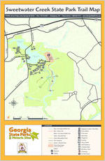
Sweetwater Creek State Park Trail Map
1750 Mt. Vernon Road, Lithia Springs GA 30122 Park: 770-732-5871 Emergency: 911 Reservations: 1-800-864-7275 www.GeorgiaStateParks.org
EXIT 44
I-20
Thornton Road
EXIT 41
Monier Blvd.
PARK BOUNDARY
I-20
Blairs Bridge Road
Lee Road ed
Mt. Vernon Road
Sweetwater Creek
George H. Sparks Reservoir
#8 #9
P PARK BOUNDARY
#10
ar Terrace Road
#2
C
#1
P
B
George H. Sparks Reservoir
#7
V Factory Shoals Road
R
#3
#4 R
#5
P
#11
#6 R
Police Firing Range
Bridge
MILL RUINS
PARK BOUNDARY
Creek
Sweetwater
Mt. Vernon Road PARK BOUNDARY
PARK BOUNDARY
Jack's Hill Area
Marsh Jack's Lake
Jack's Branch
PARK BOUNDARY
"Falls"
Sweetwater
0
1/4
1/2
1
Creek
Miles
LEGEND
Blue / Non-Game Wildlife Trail
Red / History Trail
White / Non-Game Wildlife Trail
Yellow / East Side Trail
Riverside
Forest Management Road Trail Connector
GPravreklw/ aUynpaved Road
Police Firing Range
no park visitors allowed
Stream
Restroom
P Parking
Rivers
ide Parkway
Chattahoochee River
Interpretive Center / Park Office Picnic Shelter Picnic Area Boat Ramp Playground Overlook Group Shelter R Staff Residence V Volunteer Office B Bait Shop / Store No Boating No Park Visitors
King
SWEETWATER CREEK STATE CONSERVATION PARK
Sweetwater Creek State Park is a conservation park which opened in 1976 and encompasses 2,549 acres of land 15 miles west of Atlanta, Georgia. It is the most visited day-use park in the Georgia State Parks System. The park has no overnight facilities but does offer a variety of natural, cultural, and recreational resources including hiking, picnicking, boating, and fishing. Four maintained trails cover over nine miles highlighting most aspects of the park from ridgetops to creek valleys and from many diverse plant communities to various cultural resources.
The trails are open from 7:00 a.m. to dark and are color-coded with blazes painted on the trees. The trailheads for all four trails are in the parking lot near the Interpretive Center (open 8:00 a.m. to 5:00 p.m.) where you will find more trail information as well as exhibits on the natural and cultural resources of the park. These include exhibits on the Civil War, life in the mill town of New Manchester, green buildings, and the plants and animals of the park. Water, restrooms, snacks and drinks are also available here. The Interpretive Center is one of the most environmentally responsible buildings anywhere, having achieved the U.S. Green Building Council's highest possible rating (LEED-NC Platinum).
Sweetwater Creek rises in Paulding County and has a large drainage basin of 250 square miles. After it enters the park it begins to fill with rapids near the mill ruins (up to class IV at the "Falls"). The river (creek) here drops 120 feet in elevation on its race to the Chattahoochee River. This mile-long stretch is the favorite of whitewater kayakers after a heavy rain. The direction of the river flow within the park is strongly influenced by the geology as the river changes direction often as it encounters resistant rock.
The park offers a diverse range of plant habitats, from river bottomlands and marsh to hardwood, pine and mixed upland forests to open meadows. Wildflowers are generally abundant from late winter/early spring until late fall.
The plentiful water of Sparks Reservoir and Sweetwater Creek, along with the many diverse habitats of the park also make it attractive to birds and bird watchers.
For more information about Sweetwater Creek State Park please go to www.GeorgiaStateParks.org/SweetwaterCreek or call the park at 770-732-5871.
CLIMATE DATA FOR LITHIA SPRINGS, GEORGIA
Avg. Avg.
Avg.
Month High Low Mean Precip. Record High Record Low
Jan 50F 28F 39F 5.82 in Feb 55F 31F 43F 5.08 in Mar 64F 38F 51F 5.94 in Apr 72F 45F 59F 4.50 in May 79F 54F 66F 4.32 in Jun 86F 62F 74F 4.25 in Jul 89F 66F 78F 4.59 in Aug 88F 65F 77F 4.40 in Sep 83F 59F 71F 3.60 in Oct 73F 46F 60F 3.38 in Nov 63F 38F 51F 4.21 in Dec 54F 31F 42F 4.34 in
80F (2002) 80F (1989) 86F (1995) 93F (1986) 96F (1996) 101F (1988) 104F (1980) 103F (1983) 99F (1970) 92F (1971) 86F (1968) 79F (1984)
-12F(1985) -2F (1996) 7F (1960) 21F (1987) 32F (1966) 40F (1984) 50F (1967) 48F (1968) 30F (1967) 22F (1965) 9F (1970) -4F (1962)
PARK TRAIL DESCRIPTIONS AND OTHER INFORMATION
RED / HISTORY TRAIL
1100 ft.
1050
1000
950
900
850
800 0
INTERPRETIVE CENTER
Miles RUINS
1
FALLS
Red / History Trail - 1 mile, one-way. 1 to 2 hours each way. Compacted Soil Surface EASY TO DIFFICULT
Red (History) Trail
The Red Trail, after half a mile, takes you to the impressive New Manchester mill ruins alongside the white-water rapids of Sweetwater Creek and is the recommended hike for first-time visitors. New Manchester was a mid-nineteenth century mill town which met its demise during the Civil War. A history guide for the Red Trail is available in the Interpretive Center. The second half mile of the Red Trail, downstream of the mill, continues to follow the rapids to the Sweetwater Falls area and is considerably more strenuous because of the very rocky terrain.
The Red Trail is the most frequently used trail in the park because it's the shortest trail to the mill ruins and best showcases the beauty of the creek valley.
BLUE / NON-GAME WILDLIFE TRAIL
1100 ft.
1050
1000
950
900
850
0
Miles
INTERPRETIVE CENTER
2
FALLS
Blue / Non-Game Wildlife Trail - 2 miles, one-way. 1 to 2 hours each way. Compacted Soil Surface EASY TO MODERATE
Blue (Nature or Non-Game Wildlife) Trail
The Blue Trail intersects with the Red Trail near the overlook of the New Manchester mill ruins at the one-mile mark. This trail was specifically designed to highlight the park's non-game wildlife and plant communities. The trail winds through several lovely stream coves and follows the ridges overlooking Sweetwater Creek. There is an amazing diversity of habitats here, with many species of wildflowers, ferns, shrubs and trees that make the Appalachian foothills (Piedmont) such a biologically rich and diverse place. The Blue Trail is a quieter alternative to the Red Trail and allows hikers to return to the trailhead via a loop instead of backtracking.
WHITE / NON-GAME WILDLIFE TRAIL
1050 ft.
1000
950
900
850
800 0
INTERPRETIVE CENTER
1
Miles
2
3
White / Non-Game Trial - 3 miles, one-way. 1.5 to 2.5 hours Compacted Soil Surface MODERATE TO DIFFICULT
White (Non-game wildlife) Trail
The White Trail passes through some of the most remote areas of the park west of Sweetwater Creek. It connects to the end of the Red and Blue trails following the rapids as they continue down the creek. The trail then turns west and follows Jack's Branch upstream to Jack's Lake. This stream community has a great variety of spring wildflowers. Hikers will also pass through areas covered with ferns, Bigleaf Magnolias, Wild Azaleas and Mountain Laurel. After climbing out of the lake valley the trail passes through the Jack's Hill area, a former farming community now known for its open meadows and a favorite of bird watchers.
YELLOW / EAST SIDE TRAIL
1150 ft.
1100
1050
1000
950
900
850 0
INTERPRETIVE CENTER
1
Miles
2
3
Yellow / East Side Trial - 3 miles. 1.5 to 2.5 hours Compacted Soil Surface MODERATE TO DIFFICULT
Yellow (East Side) Trail
The Yellow Trail is accessed by entering the Red Trail at the bottom corner of the parking area and then turning left after approximately 150 feet. (Look for the yellow blazes.) It then drops into the creek valley and heads upstream to the bridge across Sweetwater Creek. After crossing the bridge the trail turns downstream where, just past the wooden footbridge, you will find a fork in the path. Those wishing for a more gradual ascent up to the ridge are advised to take the trail to the left (clockwise around the loop). This trail passes through some of the most beautiful hardwood forests in the park and has an elevation gain of approximately 350 feet.
PLEASE DO NOT PICK THE FLOWERS OR COLLECT ANYTHING ON THE PARK.
SAFETY TIPS & ETIQUETTE
Tell someone your itinerary and expected return time.
Take a map, water, snacks, first aid kit, flashlight and whistle. Three short blasts on a whistle are known as a call for help.
Do not stray from trails. If you become lost, stay in one location and wait for help. This will make it easier for rescuers to find you.
Don't count on cell phones to work in the wilderness, but if they do, be able to give details about your location.
Invest in good hiking socks such as those found at sporting goods stores. Avoid blisters by carrying "moleskin" and applying it as soon as you feel hot spots on your feet. Available in the foot care section of drug stores, moleskin is like felt that sticks to your skin.
Be prepared for unexpected rain and wind which can lead to hypothermia. Always carry quality rain gear and turn back in bad weather. If you become wet or cold, it is important to get dry and warm as quickly as possible.
Dress in layers and avoid cotton. Today's hikers can choose from numerous fabrics that wick moisture, dry quickly and conserve heat. Many experienced hikers wear a lightweight shirt that wicks moisture, while carrying a fleece pullover and rain jacket.
Pack out all trash.
Keep pets on a leash at all times and clean up after them.
Do not pick flowers, disturb wildlife or take anything off the park.
Protect the park and help prevent erosion by staying on marked trails.
As the trail descends through the ravine on the south side of the loop, look for the large rock overhang on the left. Archaeologists estimate that Native Americans used this as shelter for several thousand years. To protect this area do not climb on the slope or the rocks. When the trail leaves the ravine and levels out you will be walking through many dense stands of Mountain Laurel (beautiful in the spring when they bloom). This is also the area where the bricks for the New Manchester mill were made in the late 1840s.The pits are visible from the trail in the winter.