- Collection:
- Georgia Government Publications
- Title:
- A preliminary report on the artesian-well system of Georgia
- Creator:
- McCallie, S. W. (Samuel Washington), 1856-1933
- Publisher:
- Atlanta, G. W. Harrison, state printer
- Date of Original:
- 1898
- Subject:
- Artesian wells--Georgia
- Location:
- United States, Georgia, 32.75042, -83.50018
- Medium:
- state government records
government records - Type:
- Text
- Format:
- application/pdf
- External Identifiers:
- OCLC 03556543
NZ MMS ID 9910079742302931
Call Number QE101 - Metadata URL:
- https://dlg.galileo.usg.edu/id:dlg_ggpd_s-ga-bm500-pg4-bb1-bno-p-b7
- Digital Object URL:
- https://dlg.galileo.usg.edu/do:dlg_ggpd_s-ga-bm500-pg4-bb1-bno-p-b7
- Language:
- eng
- Extent:
- 214 p. illus., vii pl (incl. front). 2 fold maps, 4 fold profiles. 26 cm.
- Holding Institution:
- University of Georgia. Map and Government Information Library
- Rights:
-

ARTE:$1AN-WELL SYSTEM OF GEORGIA
FRONTISPIECE
PLATE I
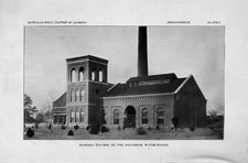
PUMPING STATION OF THE SAVANNAH WATER-WORKS.
GEOLOGICAL SURVEY OF GEORGIA
W. S. YEATES, State Geologist
BULLETIN NO. 7
)
A PRELIMINARY REPORT
ON THE
ARTESIAN~\VELL SYSTEM
OF
GEORGIA
"BY
S. "\7V. McCALLIE Assistant Geologist
1898
GEO. W. IIARRIS_0N, STATE PRINTER
FRANKLIN PRINTING AND PUBLISHING COMPANY
\.
Atlanta, Georgia
THE ADVISORY BOARD
of the ~Geological Surv~y of Georgia
( Ex-Officio) -Hrs ExcELLENCY, W. Y. ATKINSON, Governor.of Georgia
'PRESIDENT OF THE BOARD
:HoN. R. T. NESBITT
. Commissioner of Agriculture
~HoN. G. R. GLENN .
.BoN. W. J. SPEER .
Commissioner of Public Schools State Treasurer
BoN. ViJ. A. WRIGHT .
Comptroller-General
:HoK. WILLIAM CLIFTON .
HoK J. M. TERRELL .
Secretary of State Attorney-General
CONTENTS
'[_,ETTER OF TRANSMITTAL
Page
7
]NTRODUCTION
9
The Essential Conditions of Successful Artesian V\Tells. IO
a. Water-bearing Strata
I I
b. Confining Strata
I J
c. Raz'llfall
16
Unsuccessful Wells
I 8
Life of Artesian Wells
2I
Uses of Artesian Wells
--
25
Chemical Composition of Artesian \iVaters
27
Methods of Boring Artesian Wells
28
Cost of Artesian Wells .
Some Noted Artesian Wells
33
_ARTESIAN WELLS OF SouTH GEORGIA
37
Topography
37
Geology of the Coastal Plain
r',., ).)
History of Artesian Wells in South Georgia
63
Water-bearing Strata .
6s
A List of the Artesian Wells
67
Descriptive Notes, by Counties
74
:SuRFACE WELLS IN SouTH GEORGIA .
I99 -
ARTESIAN WATERS IN NORTH GEORGIA
204
rCoNCLUSIONS
207
October 20th, I 8g8.
To His Excellency, W. Y. ATKINSON, Governor, and President of tlze Advis01y Board -of tlze Geological Survey of Georgia,
SIR:- I have the honor to submit, herewith, the report of_ Mr. S. W. McCallie, Assistant Geologist, on the Artesian-Well System of Georgia. This report has been prepared, for the immediate benefit of the people of the southern part of the State; and it is intended to guide them, in the location of artesian wells, from which they may obtain a healthful water-supply. The value of such a work is so well known, as not to require comment. It 1s hoped, that this report will meet the want, it is intended to fill.
Very respectfully yours,
w. s. YEATES,
State Geologist.
THE ARTESIAN--\VELL SYSTEM OF GEORGIA
CHAPTER I
INTRODUCTORY
Artesian wells are so called from Artois, a provi~ce of France, where the first successful attempts were made in Europe to obtain water, by means of deep borings. The exact date of the completion -of the first wells seems not to be definitely known. However; thev
./
probably date from the Eleventh Century; as one at Lillers has been in constant use, since the Twelfth <:;:entury. These original wells were all flowing, and consequ~ntly the term, artesian, was first lim'ited to those wells, which overflowed the surface. The term is now often used in a much broader sense, embracing, not only the flowing, but the non-flowing deep wells.. In this latter sense, it will be used in this report.
(?)
IO
GENERAL DISCUSSION OF ARTESIAN WELLS
il'fHE ESSENTIAL CONDITIONS OF SUCCESSFUL ARTESIAN WELLS 1
The essential conditions, necessary for successful flowing art~sian1 wells, are as follows:-
Ist. An inclined, porous, water-bearing stratum, outcropping at.
Fig. I
Section through the Underlying Rocks of a Basin, Showing Favorable Conditions for Artesian Wells. a. Water-bearing Stratum. b. Confining Stratum above. c. Confining Stratum below. The Broken Line, d, Shows the Height, to Which Water Will Rise in an Open Pipe.
an elevation, greater than the surface at the location of the proposed well. 2
2nd. Water-'tight continuous beds, either of clay or some otherimpervious material, both above and below the water-bearing stratum. 2
3rd. A sufficient rainfall, to supply the porous, water-bearingbed at its outcropping, with ample water for a continuous flow.
1 For a more complete discussion of th[s subject, the reader is referred. to Prof. T. C. Chamberlin's excellent paper, on Artesian Wells, Sth Annual Rep., U.S. GeJl. Surv., r8S3-'84, p. 13r.
2 See"fig. r.
GEl\FERAL DJSC[/SSION OF ARTESIAN WELLS
I I
WATER-BEARING STRATA
Many persons, who have made no special study of the movements
of underground waters, are of the opinion, that artesian wells de-
rive their water from subterranean streams or lakes. Such, how-
ever, is rarely ever the case. The source of the water supplvinO"
'
.I
b
these wells, is found to be, in almost every instance, a saturated
Porous
deposit
called
a
water-bearinO" b
stratum.
The onlv strata
./
'
which can be relied upon, with any degree of certainty, to furnish.
Fig. 2
Section Illustrating the Thinning out of Water-bearing Strata. (a) Water-bearing Stratum; (b) a Flowing Well; (c) a Dry Well.
water, in large quantities, consist of sand, gravel, conglomerate or porous limestone. The crystalline rocks, including granites, gneisses . etc., have, in a few instances, given a copious supply of water; but, as a general_ thing, this source of supply is too uncertain, to warrant extensive outlay of money in well-prospecting. It might be stated, as a common rule, that the more recent geological formations, including the Tertiary and the Quaternary deposits, are the chief sources of artesian waters. While the statement is true, in the main, there are, however, some notable exceptions; for instance,
1
the Potsdam Sandstone of the Upper Cambrian. The amount of water, furnished by any given stratum, bears no
1 Artesian \Vells of Iowa, by W. H. Norton, Iowa Geological Survey; Vol. VI, p. rsr.
GENERAL DISCUSSION OF ARTESIAN WELLS
:relation, whatever, to its age; but, on the contrary, it depends .almost entirely upon the porosity of the beds, and the rapidity, with whi_ch the water circulates through them. Other things being equal, the most copious flowing-w_ells are always obtained from .strata having the largest spaces, between the individual particles -constituting the beds. This con~itlon is most nearly fulfilled, in very coarse sand or gravel beds. These beds, however, are usually .,of limite<;i extent, and cannot be relied upon for water-supply over large . areas. I Moderately fine sands and porous limestones are the ;:more widely distributed water-bearing strata. These frequently
Fig. 3
Section Illustrating How Horizontat Strata, with Upturned Eroded Outcropping, May Become a Source of Artesian V\Taters. a. Water-bearing Stratum. b and c. Ci:mfiriing Strata.
~underlie hundreds of square miles, and yield bountiful supplies of -water, when pierced by the drill. If the sands are quite fine, and -contain mote or less clay; they become unimpo'rtant water-carriers, .by reason of the slowness, with which a liquid oqz~s through a substance, containing minute interstices. Such beds may give the de_sired head of water; but they can never furnish a copious flow.
The inclination of a water-bearing stratum has much to do with its economic importance, as a water-carri~r.. If the stratum dips . at a high angle, it not only soo,n reaches a depth,. at which well.ibor'ing becomes impracticable; but' it; also, at the same time, re,,.duces the superfici2d extent of 01:ltcrop, which is the ar:ea of catch-
I See fig. 2.
GEi'.TERAL .D.!SCUSSJO.N OF AR7ES.!A.N n'ELLS
I 3.
ment, or intake. This is one of the chief reasons, whv the more ..)
recent, undisturbed strata are usually the most fruitful source of artesian waters.
The water-bearing beds may slope, either gradually in one general direction, as along the Coastal Plain of the United States, r or they may dip toward a common center, as in the London and the Paris basins.2 In the former case, the water-bearing stratum exposes only one edge, as an intake area, while the latter presents.
Fig. 4
Section through the Underlying Rocks of a Basin, Showing Two Water-bearing Strata.. The Upper Stratum; a, Furnishes a Flow; While the Lower, a/, Does Not, Because the Outcropping Is Reduced, by Denudatio11, to a Lower Level, than the Surface at the Mouth of the Well. This Section Shows Why the Lowest Water-bearing Stratum Does Not Always Have the Highest Static Head. a and a/. Water-bearing Strata. b. Confin- .ing Strata. d and e. Static Heads of the Water-bearing Strata, a and a/, respectively..
four. Thus it is, that basin-shaped areas frequently furnish such enormous quantities of artesian water. It often happens, that strata dip, at a rather steep angle at their outcroppings, and then extend, for a long distance, nearly horizontal, or are again brought near the surface by gradual undulations or folds. In such in-stances, the outcropping of the water-bearing beds, which constitute the intake or catchment area, may be on the flank of themountains, a hundred miles or more, distant from the location of the wells on the plains. These conditions are frequently met with, ..
1 See fig. 19.
2 See fig. 4
GENERAL DISCUSSION OF ARTESIAN WELLS
"'on our western prairies; and they also exist at many places on the -rainless desert of Sahara.
At any one given locality, favorable for artesian wells, there are usually more than one water-bearing stratum. Often, there are several, separated by clay or other impervious materiaL Each of -these water-bearing beds acts as a separate reservoir for water-stor.age,1 so that, when one becomes exhausted by an overdraft from a multiplicity of wells, the other beds can be penetrated and drawn 'Upon. This fact is well illustrated by the history of the artesianwell system of London. In the early part of the century, a great number of wells, from So to I 50 feet deep, were sunk in that city; ..and a large supply of water was obtained; but, in a short time, th.e wells became so numerous, and the draft on the water-bear-ing .s"trat:um was so great, that many of the wells had to be abandoned, ,()T driven to greater depths, in order to obtain a continuous flow.
It is a well-known law of physics, that water always seeks its level; that is, if allowed' to move freely, it will stand at the same height in the pipes connected with. a reservoir, as in the reservoir
-itself. According to this principle, it is practically impossible, to
:obtain a flow from a deep boring, unless the water-bearing stratum, which constitutes the reservoir, outcrops at a greater elevation, than -the si.ltface at the proposed well. Even when this condition is fulfilled, there is not always the desired flow, owing to the leakage of the confining strata, or the slowness, with which the water circuIates through the water-bearing ~eds. From_ these statements, it --will be readily understood, how important it is, for the practical we'll..;borer to possess a knowledge of the topography and geology of -the region to b~ prospected. This information enables him to pre~dict, with a considerable degree of certainty, not only the different
1 See fig. 4
GENERAL .DZSCUSSZOi\l OF ART.ESZAJv" wELLS
IS
formations to be penetrated, but also the practicability of securing water, at reasonable depths. The lack of such knowledge has frequently caused the expenditure of large sums of money, in fruitless efforts to obtain flowing artesian water, at places, where the geological structure shows that it cannot possibly exist.
CONFINING STRATA
The confining strata :consist of clay, shale, marls and other deposits made up of exceedingly fine grains. The particles of these
Fig. 5
Section through the Underlying Rocks of a Basin, Showing Unfavorable Conditions for Successful Artesian Wells. a. \Vater-bearing Stratum. b. Confining Stratum above. c. Confining Stratum below. d. A Gorge Cutting the Upper Confining Stratum, and Allowing the Water to Escape in Springs at a Lower Level, than the Surface at the Mouth of the Well, e.
beds are so closely united, that there is no space between the individual granules, for the free circulation of water. The clavs are
..1
the most impenetrable to water, of all confining strata, and are, at the same time, the most continuous. They are practically impervious, even under great pressure, and often extend, as unbroken beds beneath extensive areas. Shales, which differ from clay, chiefly in being indurated, or in a hardened condition,
r6
GENERAL DISCUSSION OF ARTESIAN WELLS
also form important confi?ing beds. These deposits, however, are liable to be jointed and :fissured in the process of consolidation; and r for this reason, they are not sci impervious as the clays. Marls, sandy clays and clayey limestones each form confining strata, of more or less impermeability; but, as they are of a somewhat porous. nature, much of the water, confined by them, frequently escapes. by leakage. Especially is this true, if the water be under great pressure. In all instai1ces, where successful artesian wells are obtained, there must be at least two of these impervious beds, one of which lies above, and the other, below, the water-bearing stratum. Should either of these become fissured, or otherwise discontinuous, from any cause, the confined water escapes by leakage, and appears. at the surface, forming springs.1
RAINFALL
The quantity of water, obtained from any given system of artesian wells, can never exceed the amount of rainfall, which enters the water-bearing stratum at its outcropping. Water, falling upon .the surface of the earth in the form of rain, disappears by evaporation; is carried off by surface drainage; or is taken up by the porous soils. Only that portion of the rainfall, therefore, which is absorbed by the soils, has any direct bearing on the question of artesian wells. The amount of rain, taken up by any soil, depends. upon its p()rosity, and its surface inclination; and, also, upon the rapidity, with which the rain descends. If the surface of the
1 See :fig. s.
GENERAL DISCUSSION OF ARTESIAN WELLS
17
soil is nearly horizontal, and is made up largely of sand, it will absorb a high percentage of the total rainfall. But, on the other hand, if the surface slopes .at a considerable angle, and the soil consists largely of clay, the greater part of the water will be carried off, by surface drainage. Furthermore, when the rain falls in heavy showers, the pores of the soil, however large, become overgorged, and much of the water escapes, in rills, to the adjacent brooks; whereas the same soil will absorb nearly the entire rainfall of more gradual showers. Thus it is, that heavy showers flood our streets and swell our brooks. It is impossible to state, with any degree of accuracy, the relative amount of the total rainfall actually absorbed by the soils; however, where. the above conditions are most favorable, it is probable that a greater part of the entire precipitation is absorbed. Even when there is only a small percentage of rainfall taken up by the soils, the total amount, when collected over extensive areas, is enormous. Some idea of the vast quantity of water annually precipitated may be gained from the following statement:- The city of Atlanta consumes daily about s,ooo,ooo gallons of water. )'et, the average total daily precipitation, within the city limits, annually, exceeds this amount, many times. In other words, the most densely populated portion of the city does not use .as much water, annually, as falls in its streets and upon its housetops, during the same interval. If only a thousandth part of such rainfall could become available for artesian wells, it would be ample, to supply the most thickly populated portion of the State, with abundance of water, for all domestic purposes.
I8
GENERAL D.!SCUSSION OF ARTES.!AN WELLS
UNSUCCESSFUL WELLS
The main cause of unsuccessful artesian wells is due chiefly, of course, to the absence of the required water-bearing strata. This, however, is not always the case. Frequently, such water-bearing beds exist; and they' may even be penetrated by the wet process of well-boring, without giving any marked indication of their presence, at the surface. This point is' admirably discussed, and is well illustrated, by Prof. Chamberlin, in his excellent paper on artesian wells, published in the Rifth Annual Report of the United States Geological Survey. ,In speaking of the defective flows oL artesian wells, Prof. Chaniberlin says: - I. "Suppose that two porous beds, A and B (fig. 6), separated by an impervious layer, are traversed, and the testing of the first has been neglected, either because it failed to give encouraging indications c:r for other reasons. It is now desired to test these. Suppo~e the seed-bag or rubber packing be placed abdve the upper one. Now, if both'bear a water-level equally high, the test will be fairly made, and the result will indicate their com- bined capacity; or, if both heads are at least as high, as the surface
$
at the well, the test rnay be accepted. But suppose that the bed A has been cut into by erosion, or been reached by crevices, or is otherwise defective, while the other, B, remains intact and bears an elevated fountain head. Under these conditions, the water may
flow from B, through the bore into A, and escape laterally through
it, as l'llustrated in the figure. Now, in this case the result may be either simply negative, or positively false and misleading. If the lateral leakage through the stratum A effectually disposed of the flow from B, and there was no leakage in the upper portion of the well, the water in the test-tube would stand during the test at es-
GENERAL D!SCUSSZON OF ARTESZAN WELLS
19
sentially the same height as before, and the result would be nega-
tive, merely failing to indicate a possibility that really existed.
If, on the other hand, there was lateral leakage through the upper
strata, as well as through A, neither alone being quite competent to dispose of the flow from
Fig. 6
B, then the introduction of the test-pipe would
cut off the upper leakage, leaving the bed A un-
able to dispose of the entire flow. In this case,
there would be a rise of water in the tube, and,
possibly, a flow. The mischievousness of a test
of this sort lies in the fact that it appears to be
a true test, because it shows some result, while in
reality it is false and misleading. The true test
in this case can only be made by placing the
packing between the porous beds A and B.
2. Take another instance where two porous
beds, as A and B (fig. 7), have been traversed.
Let the packing be placed between these. Then
(1), if A equals B in productive capacity, wate~
will stand at the same height within and without
the te;:;t-pipe if there is no leakage in the upper beds.
(2) If the failure to flow was due to such leakage,
then a flow will result from B, but the additional Section of a Well
flow which might be secured from A, is lost (See figure). (3) If A has a greater head than B, and there is no loss above, the water in the test-pipe
Illustrating a Negative Test (After Chamberlin).
will actually be lower than that outside, as illustrated in figure 8.
This may be said to be an inverted test, and is less misleading than
the false and negative tests, since it plainly indicates an error of
manipulation. I have known such a case of reduced head as the
20
GENERAL DISCUSSION OF ARTESIAN WELLS
result of all attempted test.. (4) If, however, there is in this case
considerable lateral waste in the upper strata, the valuable flow from
Fig. 7
A will be lost, just as before the test was made, while B may give a rise in the tube, or even a
flow, which, would foster the. impr-ession, that a
fair test had been made, while in reality the
greater flow has been lost. (S) If A gives a
feebler flow than B, but has an equal head, the
test will fail of being completely satisfactory only
in excluding the feebler flow from A. (6) If,
however, A has a lower head, and is a possible
means of escape for the flowage from B, then the
packing has been placed at the right point, and
the test gives the best results..
3. In still anotheF case let A and B represent
porous beds (fig. 9) the lowerof which is so con-
ditioned as to drain the upper one by virtue of
a lower outcrop. (I) First, if the drainage-loss
. below is not complete, and if the packing is
placed above A, as shown in figure g, I, the result
will be negative, if there. is ,no leakage in the
Section of a Well, upper strata. ( 2) Should there be considera-
Showing Partial an d Misleading Tests(After Chamberlin).
ble loss there, it will be cut off by the tube and packing; and some rise in the tube will be the result, in most cases. In either instance, the result is misleading, particularly in the last; because
the small rise of the water is apt to allay any suspicion, as to the
effectiveness of the test. The real fact, however, remains that
the flow from the productive stratum is mainly lost below. (3) Sup-
pose that the package is located between A and B, as in figure g, II,
GENERAL DISCUSSION OF ARTESIAN WELLS
2!
it will then shut off the flow from A, while that in B, because of
a lower outlet, will fail to flow. Now, if there is opportunity for
lateral leakage in the upper strata the water from A will rise in the well outside of the test-pipe, and pass off into these open upper beds. (4) But, if
Fig. 8
r
no such opportunity is afforded, it may rise to
the surface and overflow outside of the test-pipe,
while the water within the test-pipe will probably
be found to be lower, than before the test was
made. The proper method of testing wells
known or suspected to present these conditions
is to sink a simple bag of seed or other obstruc-
tion to a point in the impervious stratum between
A and B, which, when it tightens in its place, will
shut off the flow below. Then a tube with pack-
ing sunk to a point above A, will effectually cut
off all leakage in the upper strata, and the full
capacity of the water-bed, A, will be tested."
LIFE OF ARTESIAN WELLS
Section of a Well,
Illustrating an In-
It is the prevailing opinion among persons, unfamiliar with artesian wells, that they, like natural
verted Test (After Chamberlin).
springs, will continue to furnish water for an indefinite period, with-
out a diminution of flow. Such, however, is an erroneous idea. It
is a rare thing, that a well furnishes a continuous flow, for many
years, unless the pressure be unusually high. There are several
causes, which tend to cut short the life of artesian wells, besides
the actual decrease of the water-supply. The most important of
22
GENERAL DISCUSSION OF ARTESIAN WELLS
these are the decay of the casing and the accumulation of sand, or other foreign material, in the bore-hole. All wells, unless they penetrate solid rock or tough tenacious clays, have to be cased with iron piping, in order to keep the sand, or other loose material, from falling in, and closing up the bore-hole. In sinking a well through sands and other friable deposits, it is customary to drive the casing down, a.s the drill descends, sp that, when the borehole is completed, it is cased to the bottom, and the water flows directly to the surface, without coming into immediate contact with
Fig. 9
Section of Strata and Three Wells, Showing One Correct and Two Erroneous Tests. These'.Wells Are Assumed to Be Independent of Each Other, and Are Placed
'1'og.ethe:t:on the DiagramMerely"fol""Gonvenience" (After Chamber-Tin).
the overlying strata. The casing, used for this purpose, is usually
made of wrought-iron, in sections, from ten to fifteen feet in
o~;
length, which are screwed into each other, forming water-tight
joints. As these pipes are only a fraction of an inch in thickness,
they undergo decay, in a few years, and have to be renewed; other-
wise, the falling in, or the creeping of the walls of the bore-hole,
stops the flow, and the well has to be abandoned. The length of
time, that a casing will last, is quite variable, d~pending largely
upon:~thecharacter of ~he. minerals;.held in. so1ution by the waters.
If the waters are almost chemically pure, the casing may last, for
many years; but, if, on the contrary, they contain hydrogen sulphide
GENERAL DISCUSSION OF ARTESIAN WELLS
and other rapidly corroding gases, the casing has to be frequently
renewed.
The most fruitful cause of trouble, in flowing artesian wells, is the
accumulation of sand in the lower portion of the bore-hole. This
source of annoyance increases, as the pressure of the water in the
well decreases. That is, a well, having a small discharge and, con-
sequently,
a
low
pr.essure,
is
more
liable
to become
.
obstructed
with
sand, than one, having a large discharge and a high pressure.
Should the pressure be unusually high, and the well is not immedi-
ately cased aft~r its completion, there is sometimes danger of the
well's causing its own destruction. This is brought about, by an
enlargement of the bore-hole, which produces an overdraught on
the water-bearing stratum. Prof. Norton gives the following
description of a well of this nature, put down at Belle Plaine,
Iowa, in I 886: -"Local historians of the well, which they please to
term 'the eighth wonder of the world', state, that the beginning of
the trouble lay in the fact, that the driller attempted to use the
force of the flow, in reaming out the two-inch bore, which he had
put down, for want of a larger' driU, to three inches, the dimension
specified in the contract. This task, the water speedily accom-
plished, in the unindurated clays and sands; but, not stopping
there, went on and soon enlarged the bore to over three feet in di-
ameter.- Through this shaft the water boiled up iri a fountain, five
feet in height (the press reports, giving several hundred feet, as the
height of this fountain, were exaggerated), flooding the streets and
yards, and covering them with sand. It is estimated, that from 500
to I ,ooo car-loads of sand were discharged from the well. The
quantity was certainly so great, that, only with the greatest effort,
could the ditches be kept open, to carry off the water. Gravel and
small pebbles of northern drift were thrown out, and some pieces
GENERAL DISCUSSION OF ARTESIAN WELLS
of fossil-wood, two and three feet long. The maximum flow of
water was variously estimated at from s,ooo,ooo gallons to g,ooo,-
ooo gallons per diem. Two. wee,ks after the well was drilled, '
Chamberlin calculated its discharge at 3,ooo,ooo gallons, for the
same period. , The enormous flow rapidly drew down the head
of the other wells, until it sank beneath thesurface. The attempts,
to case and control the well, continued from August 26th, I 886;
the date, when water was struck, tp October 6th, r887, when the
task was successfully accomplished.
''During this time, the well, 193 feet deep; devoured, as lpcal
historians tell us, 16~ feet of eighteen-inch 'pipe, seventy-seven feet
of sixteen-inch pipe, sixty feet of five-inch pipe, an iron cone, three
feet in diameter and twenty-fou.r feet .long, forty car-loads of stonei
I 30 barrels of cement, and an inestimable amount of sand and
day."
As is stated above, the diameter of a well, also, has much to do
with: rapidity, with which the bore-hole becomes clogged. The
smaller the diameter, the more rapidly will it be Obstructed,. other
things b'eirtg 'equal. , Fot this ,reason, flowing wells should, nevet
he: tess than three ot tour: inches in ,diameter. The decrease of
flo\v~, when due. to-'- the' accuin:ulation of sand in the lo'wer part o
the cading, :uslially takes place gradually, and often extends throtlgn
mirty mortths,bdore. there is a. complete cessation. In such in.;
stances; it is necessary only to use the sand-pump, in removing th~
obstruction, ih order to regain 'the former water-s'upply.
'l
,,
GENERAL DISCUSSION OF ARTESIAN WELLS
USES OF ARTESIAN WELLS
The original artesian well in the province of Artois, France, was _put down, with the object of obtaining water, for domestic pur--
poses. The majority of wells, now constructed, have a similar object in view. Nevertheless, there are also many wells put down for other purposes, such as irrigation, water-power and h~ating. Artesian wells, constructed for irrigation purposes,_ are confined chiefly to arid regions, where the amount of rainfall is insufficient, tosupply the growing crops. In such districts, the total annual precipitation, in the form of snow and rain on the adjacent mountains and elevated areas, is frequently quite large. Part of this precipitation is taken up, by evaporation; part of it is absorbed by the up-turned edges of the porous strata, which extend beneath the arid region below; and the remainder rushes down the mountain-side tothe plain, where it, in turn, is either evaporated, or absorbed by thehungry, parched soils. The water, thus taken in, by the upturned. edges of the porous strata and hungry soils, gradually descends by gravitation to an impervious bed, which it follows, be_neath the arid, region, and becomes the source of artesian waters~ These catch-ment or intake areas are frequently a hundred miles or more, from the location of the well.
Artesian wells, constructed mainly for the purpose of irrigation,_ have long been in use, in the desert of Sahara. Many of the beautiful garden spots, in that arid region, called oases, with their luxuriant growth of palms, are said to be solely due to the supply of water from flowing wells.
China, Italy, Spa~n and the western part of the United States, each annually utilize large quantities of artesian waters, for irriga-
:26
GENERAL .DISCUSSION OF ARTESIAN WELLS
-tion purposes. The most extep.sive system of artesian wells, in this country, used for irrigation, are to be found in the San Joaquin Valley, California; in the Great Salt Lake Desert of Utah; and in _South Dakota.
When the artesian waters escape from the bore-hole with great force, or under a heavy pressure, they frequently generate sufficient -energy to operate extensive machinery. This is o.ften the case, when the fountain-head is at a much greater elevation than the -well, as in the Dakotas. Mr. N. H .. Darton, in nrs' exceilent report -on the artesian wells of Dakota, says:-" These waters rise to the :surface with pressures, which are often over roo pounds per square inch, and, in a few instances, over I 50 pounds. At a number of .locations, this pressure is directly used, for power, to run large flouring mills, electric-light plants, sewerage pumps, and other ma...chinery ". In a few instances, attempts have been made, to utilize the pressure of some of the wells in South Georgia, for the purpose of Loperating machinery; but they have met with only a partial success.
It is a well known fact of geology, demonstrated by all deep ~Jen~;."an'd mines, "that below the poi~( of no annual variation of ~temperature, there is a gradual increase of heat, downward, averag.. ing about I Fahr. for every 55 or 6o feet of descent. That is, a well, say 2,000 feet in depth, will furnish water having a temperature of 8b0 or 85 Fahr. For this reason, waters obtained from very deep w~lls always have a high temperature. The amount of heat, daily liberated -from such wells, is often very great; and, in .:Some instances, it has been utilized and made of pecuniary value. The high temperature of the water, from one of the Grenelle arte.sian wells, is utilized, in heating a hospital. Large manufacto_..ries in Wiittem:herg, Ger,ma:n)',,a-re .warmed by the s~me means. Erfurt, Saxony, and Paris, France, each have large gardens, kept ..at uniform temperatures by artesian wells.
GENERAL DISCUSSION OF ARTESiAN WELLS
27
CHEMICAL COMPOSITION OF ARTESIAN WATERS
Artesian waters are never chemically pure; but they always carry, lin solution, numerous minerals, either in the form of solids or gases. The diversity in the chemical composition of such waters is as varied, as the chemical composition of waters, obtained from natural springs. The former, however, by reason of their high temperature and the great pressure, under which they are confined, usually contain a much higher percentage of minerals, in solution, than the latter.
The most common gases found in arte.sian waters, are ammoma, hydrogen sulphide and carbon di-oxide. The ammonia seems to be derived, mainly from the decomposition of organic matter; and, when it exists, even in very small quantities, the water is often condemned for drinking purposes. This is not due to the ammonia's being hurtful within itself, but its detection indicates the presence of disease-producing organisms. H ydrogerr sulphideds frequently met with, in artesian waters, especially if the well penetrates the more recent geological formations. This gas has a very disagreeable ' odor, but it rapidly disappears, when the water is exposed to the atmosphere. Carbon di-oxide is present, in all underground waters; but rarely does it exist in sufficient quantities to be detected, except by chemical means. When it is present in large quantities, it forms a natural soda-water, which has an acid taste and aids digestion.
The most common solids, found in artesian waters, are the various carbonates, sulphates and chlorides, together with silica, alumina and iron. These several compounds, when present in unusual quantities, give rise to chalybeate, saline, magnesian-and other mineral waters, many of which possess medicinal properties.
28
GENERAL .DISCUSSION OF ARTESIAN WELLS
METHODS OF BORING ARTESIAN WELLS
The method, usually adopted, m boring deep wetls thr-ough
Fig. IO
solid rock, is similar to the process ap-
plied by the quarry-
man, in removing
stones from their nat-
ural ledges. It con-
sists in penetrating
the rock by means of
a steel chisel, called
a drill. This instru-
ment, which has a
sharp cutting edge of
hardened s tee 1, is.
struck.by a hammer,
or is raised and let
fall w i t h i t s ow n
weight, thereby im-
parting to the rock.
at one point, a series.
of sharp, heavy
blows. Small frag-
ments of the rock
are thus removed, at
each blow, and the
Illustration Showing Complete Artesian-Well Boring Outfit.
d r i 11 sl0wly penetrates the rock, form-
GENERAL .DISCUSSION OF ARTESIAN WELLS
ing a circular hole. In boring deep wells for artesian waters, the
boring tools are usually operated by steam-power, in the place of
manual labor. A complete well-boring outfit consists of numerous
tools and appliances, used only by. the professional .
Fig. II
well-boring engineer. One
of the first things to attract
the attention of an ob-
server, in approaching a
well under construction, is
the pyramidal frame-work,
30 to 57 feet in height,
erected over the well. I
This structure, known as
the derrick, supports the
pulleys, over which passes
the cable, that is used, in
removing and lowering the
boring-tools in the well.
The boring-tools consist
of several parts, called the
bit, the, auger-stem, the
jars, the sinker-bar and
the rope socket. The bit
is the chisel-shaped piece
of steel, forming the cut-
ting tool, attached to the lower end of the auger-
Boring-Tools Used in Sinking Artesian Wells.
stem. It varies in size, according to the diameter of the well to be
bored, and can be readily detached from the auger-stem, when it
I See fig. ro.
GENERAL D.lSCUSSJON OF ARTES.lAN WELLS
needs repairing. The auger-stem is an iron rod, 20 or 30 feet long,
uniting the bit with the jars, which is an ingenious device, consist-
ing of two elongated links, having a play of several inches. One
of the links is attached to the auger-stem, and the other to the
Fig. I2
sinker-bar. The one, united to the augerstem, aids in giving the 'downward blow;
while the other gives a sudden upward mo-
tion to thedrill, which loosens the bit from
the rock. .The sinker-bar is an iron rod,
several feet in length, extending from the
jars to the rope-socket, which, in turn, is at-
ta'cheCi' to the cable, used in raising and lowering' the chain o"f tools into the well. The
upward and downward motion is usually im-
parted to the boring-tools, by what is called
a walking-beam, a ridged iron or wooden
beam, working a pivot, operated by a-crank,
which is propelled by an engine or some
.other motive power.
" The borings are removed from the well
Diagram Illustrating the Hydraulic Revolving Process of Sinking Well a. H_?llow~ Auger Stem b. \Vater Exit. C: Water In:let. d. Cone. e. Auger Bit.
by a sand-pump. This is a long iron cylinder, with a valve in its bottom, opening upwards. When the sand-pump is lowered into the well, the borings, which are in the ~orm of a liquid mud, rise into it, the valve
closes, and the cylinder, with its contents,is elevated by means of
a rope attached to its bail. There is another method of well-boring,
now almost exclusively used in South Georgia, in deep-well construc-
tion. It is locally known, as the wet process, and it differs from the
above described method, mainly in the manner of removing the
GENERAL D.!SCUSS.!ON OF ARTESIAN WELLS
borings from the well. This is accomplished by forcing water,_ under a heavy pressure, down the hollow auger-stem to the bit, where it escapes through an aperture, and carries the loose fragments . of rock etc. to the surface, through the open space between theauger-stem and the sides of the bore-hole. A third method, fre-quently used in boring wells in alluvial and unconsolidated de-posits, is called the hydraulic rev:olving process. The boring apparatus, used in this case, consists of an iron-pipe, shod with a steel toothed cutting-edge at its base. As the pipe revolves, it cuts-through the clays and sands leaving a cone in its center, which is. washed out, by the water, forced into the pipe from the surface.1 ' The principles, involved in this process, are identical with thoseused in the diamond drill, which is also sometimes used in well--boring.
THE COST OF ARTESIAN WELLS
The cost of artesian wells depends chiefly upon the character of-: the formations to be penetrated; the size of the bore-hole; and the depth of the well. If the formations penetrated consist of graniteor other hard crystalline rock, the cost of actual boring will bemany times greater, than if the formations were made up of sand, clay or other unconsolidated deposits. Only a few feet per day, at_ best, can be made, in the hard, crystalline rocks, with the best of. outfits, under a skilled well-borer; whereas, fully as many rods can . be accomplished in the same time, with less effort, in sands and._ clays. vVhen the bore-hole is to be unusually large, it requires an..
1 See fig. 12.
GENERAL .DISCUSSION OF ARTESIAN WELLS
..enlargement of. the boring-tools, which de~ands a corresponding ;?increase of the motive pc,>wer, used in driving the machinery. This difficulty is, however, sometimes overcome by first drilling a small i.hole, and, afterwards, increasing its size, by the .use of the reamer. After a well has attained a depth of a few hundred feet, the diffi~culty of manipulating t~e boring-tools becomes greater; and, at the ,same time, the dropping of any portion of the .drill in the well is tlllore than likely to prove fatal. Portions of boring-tools, dropped jnto deep wells, frequently requir~ great ingenuity and many weeks .,o.f labor, to remove them. It is said that, in putting down the noted .artesian well at Grenelle, France, in I 84 I, a portion of the drill became detached, and dropped to the bottom of the hole, which .had then attained a depth of ~.254 feet. To remove this obstruc-ti"on from the well, required nearly fifteen months of constant ;labor.
Prof. Chamberlin, in discussing the cost of artesian wells, says:-"The driller, familiar with the general character of the strata of the :r.region, demands an average price,- depending on the depth. While t~is varies, an approximate idea of expense may be obtained by .:.re<;:koning from $2.00 to $3.00 per foot for the first I,ooo feet, and .an increase of a half a dollar per foot for each 500 feet below that, .down to the limits practicable fc,>r boring. To this is to be added the cost of tubing, which ,will vary greatly with the situation and c-eharacter of the strata".
~
Prof. Norton, in his report on the artesian wells of Iowa, gives the following notes on the cost of cons_tructing artesian wells in that State: -
"The well at Anamosa penitentiary was constructed at the fol:lowing prices, i11cluding c~sing, the penitentiary _fur~ishing only "coal and water and the work of two men:-
AR TESIAN- WELL SYSTEM OF GEORGIA
PLATE II
WATER WORKS PLA T AT ALBA Y, GEORGIA.
GENERAL D.!SCUSSZON OF ARTESZAN WELLS
From
I to 1,200 feeL ___ ---------- $r.75 per foot
" !,200 " 1,400 " -------- -----~- 2.00 " "
" I,400 " r,6oo " ------ ------ -- 2.25 " "
" r,6oo " r,8oo " -------- ------ 2.50 " " " r,8oo " 2,000 " -- - - --- -- ----- 2.75 " "
The Holstein well was constructed at the following scale:-
From
I to soo feeL ___ - - ------- $2.00 per foot
"
soo " 1,200 " - --- - - ----- ---- 2.2 5 " "
" I,200 " r,soo " - --- -- - - - - - - - - 2.7 5 " "
" I,soo " 2,000 " - - - - - - - - - - - --- 3.00 " "
The so-called artesian well in Atlanta, 8 inches in diameter, and 2, I 75 feet deep, was put down by the city authorities at a total cost, rincluding machinery, of $34,000, an average of about $r6.oo per :foot. This well penetrated gneiss, its entire depth, which partially ..accounts for its unusual cost. The price, by contract, for 4-inch ,-deep wells in South Georgia, including casing, runs from 75 cents -to $2.00 per foot. These wells penetrate sands, clays and soft :1imestones, which reduce their cost to the minimum.
SOME NOTED ARTESIAN WELLS
The most noted deep wells of Europe are those of France, Eng1and and Germany. The wells of France are remarkable for their number, gigantic size and enormous flows. The Passy well of _Faris, completed in 1857, attained a total depth of 1,923 feet. It
:.has a diameter of 2 Ji feet, and furnishes, at a height of 54 feet
above the surface, s,588,ooo gallons of water, daily. A still more
34
G,ENERAL DISCUSSION Of ARTESIAN: WELLS
remarkable well is the mammoth well at LaChapelle, which has a
diameter of 5Yz feet, and extends to a depth of ~ore than I ,ooo
feet below the surface. The well was put down,, by J.?.?.eans of a huge drill, weighing 4 tons, operated by a powerful steam engine, which imparted, to the boring instrument, 20 strok;:es p:er mir:mte. The artesian well at Grenelle, in the vicinity of Paris, .i:!;lr,also celebrated. This well, for many years the deepest in the world, was begun in I 834 ; and, after seven years of almost incessant toil and mishap, it was completed, having attained a depth of 1,798 feet. Near the bottom of the well, a large subterranean cavity'was penetrated by the drill, from which, water, having a temperature of 82 Fahr., rose, with great force, to the surface, forming a perpetual fountain, many feet in height.
The most noted artesian wells of England are sitqated in the city of London, and along the east coast of Lincolnshire~ In the early part of the present century, innumerable borings, from roo to 400 feet deep, were put down in London, in order to secure wate1; for domestic pu~poses. The water, thus obtained, was, for many years, One of the chief sources of supply to the .cit ; but, owing to the large number of wells and the continual draught on the water-bearing stratum, the supply of each individual well has become greatly reduced; and, as a result, many of them, which formerly furnished large quantities of water, have since been abandoned, on account of the cessation of flow.
The artesian wells of Germany are quite numerous, and many of them are celebra~ed, for their remarkable depth and great size. The famous Sperenberg well, near the city of Berlin, has a diameter of I 6 feet, to the depth of 280 feet, from whence it is continued to the unusual depth of 4, I 94 feet, with a diameter of I 3 :inches. The stratum, penetrated below the 280-foot level, consists
GENERAL .DISCUSSION OF ARTESIAN WELLS
35
entirely of rock salt, which here attains a thickness of more than 4,000 feet. Probably the deepest well in the world, at present, is the well at Schladenbach, near Leipsic, completed a few years ago.
It was extended to the extraordinary depth of 5,73 5 feet, nearly
I ~ miles below the surface. The successful completion of the deep wells of France andEng-
land, during the early part of the century, was soon followed, by attempts to obtain water, by deep-well borings in the United States. The earliest of these wells, to attract wide-spread attention, especially in the South, were the several borings at Charleston, S. C., begun more than 50 years ago. These first wells were only partially successful ; and it was not until a quarter of a century afterwards, that they were put down to a sufficient depth, to secure the desired quantity and quality of water. The deepest of these wells are now sunk to the depth of nearly 2,000 feet, where a large
quantity of wholesome water, having a temperature of 99 Yio Fahr.,
is obtained. In r 8 58, ten years after the completion of the first artesian well
at Charleston, a deep well was put down at Louisville, Ky. This well, three inches in diameter, was extended to the then unusual depth of 2,086 feet, where a strong flow _was struck, furnishing daily 330,000 gallons of water, highly impregnated with mineral matter. Another. notable well of the United States, and one that deserves special mention, on account of its great depth and early completion, is the deep boring at St. Louis, Mo., put down in I 868.
The well has a total depth of 3, I 47 feet. The water is saline, and
is unsuitable for domestic purposes. It was during this decade, that the oil fields of Pennsylvania
were attracting universal attention, and deep-well borings, which were seldom undertaken in this country, at once become a problem
GENERAL DISCUSSION OF ARTESIAN WELLS
of great economic importance. The well-boring industry now, for the first time, became a continuous and lucrative business.. It soon attracted the attention o skilled engineers, whose ingenuity and patience overcame, to a great extent, many of the obstacles, previousJy encountered in deep borings, and thereby made it possi?le, to sink wells to great depth, at a greatly reduced cost. In these oil fields, were trained many of the engineers, who afterward went fqrth to all parts of the United States, plying their trade, in sinki~g deep wells, to obtain water for domestic, irrigation and various other purposes. The extent of the artesian-well system, thus established in the United States, probably now surpasses that of any other country. Their number, which already aggregates many thousand, is now being augmented each year, by the completion of hundreds of others. They are found in great numbers along the Atlantic sea-coast, from Maine to Florida. The Mississippi Valley is perforated by them, and they are common on the dry plains of the West. These wells vary, from a few rods to nearly a mile in depth. The deepest well i.n the country, at the present time, is one near Pittsburg, Penn., which has a total depth of 4,62 5 feet. Another noted deep well is the one at Wheeling, W. Va., completed m 1892. It attains a depth of 4,500 feet, and is remarkable, for containing little or no water below the r,6oo-foot level, although it extends through nearly horizontal strata, more than half-a,. mile below sea-level.
CHAPTER II
ARTESIAN WELLS OF SOUTH GEORGIA
TOPOGRAPHY
The artesian wells of South Georgia are confined to that portion of the State, lying south of an irregular line connecting Columbus, Macon and Augusta. The area, here included, called the Coastal Plain, embraces more than one half of the entire State. It is strictly an agricultural region, noted for its large yield of cotton and fruits, together with its extensive forests of long-leaf pine. The topography of the area, under consideration, differs but little from that of the northern extension of the Coastal Plain in the Carolinas and Virgi:r:ia. It consists of a comparatively level country, having a gradual slope towards the sea. The surface is frequently diversified by low, well-rounded hills and ridges, or wide expanses of swamp lands. High bluffs and precipitous hillsides are often met with, in the vicinity of the large streams, producing a wild and picturesque scenery, not unlike that found in the more mountainous districts of the northern part of the State. Beautiful lakes, occupying depressions of former lime-sinks and old sloes, the abandoned beds of ancient streams, with their luxuriant growth of cypress and. cane, are other common characteristic features of the Coastal Plain, along the Georgia-Florida State-line. The
(37)
TOPOGRAPHY
streams are quite numerous, and are usually sluggish. Many of them, such as the Chattahoochee, the Flint, the Altamaha, the Ogeechee and the Savannah, carry large volumes of water, and are navigable, the greater part of the year, for steam-boats of considerable size. These streams occasionally have, on either side, high banks or bluffs ; but, more frequently, they traverse low palmetto lands or swamps, which seem to be partly buried ancient valleys, . cut by the streams, when the country stood at a higher level. As the coast is approached, the bluffs along the streams become less frequent, and the river-valleys or flood-plains, at the same. time, increase in width. During the rainy season, these lowlands are frequently entirely submerged ; and the rivers are often, thereby, increased to more than a mile in width. The silt, left by such overflows, adds fertility to the soil, which is admirably suited for the cultivation of rice.
Many of the smaller streams are evanescent, the water being absorbed by their sandy beds ; or they disappear under ground in lime-sinks, during the dry season. In the more elevated areas, the small streams have considerable fall ; al').d they sometimes flow 'in deeply eroded channels, with perpendicular walls. This is notably true of the small branshes and creeks, where they .enter the eroded valleys of the larger streams. The northern portion of the Coastal Plains, where it comes in contact with the Crystalline rocks, has an elevation of from 2 50 to 8oo feet above tide-water, and shows a more advanced stage of denudation, than that portion of the Plain, lying further to the south. The streams have cut deeper channels, and the hills and ridges are more completely rounded. Extending off to the southward, from tliis more elevated region, are numerous low, flat, broad ridges, running parallel with the rivers. These seem to be the less eroded portion of a once practically level plateau.
TOPOGRAPHY
39
Still further to the south, these topogrflphic features become less marked; and they finally pass into a nearly level plain, occasionally carved into irregular hills along the larger streams. In the immediate vicinity of the coast, the surface becomes even more level; but, even here, sand-hills are sometimes seen, which add variety to an otherwise monotonous landscape. The rivers enter the ocean through wide bays and sounds, which are protected from the open sea by low, wooded islands, some of which, as the Cumberland, have an area of many square miles.
The following profiles of the several railroads of South Georgia will give a general idea of the topography of the region:-
RAILROAD ELEVATIONS
SAVANNAH, FLORIDA & WESTERN R. R.
SAVANNAH, FLORIDA & WESTERN R. R.
Station
Elevation I
(Continued)
Savannah Little Ogeechee River . . . Crosstie, East End of Bridge
" West " " "
Bottom of River . . -. Station No. Io . . . Burroughs, No. 12 . . Great Ogeechee Bridge Bottom of River Station No. r6, or Way's Branch, r8Yz Miles
Branch, 20Yz Miles
Branch, 21;.:( . . Mt. Hope Creek .Branch, 22 ~ Miles Fleming No. 24 .
25.8 Station
19.0 Branch, 25 Mile-post
. 18 4. " 26~ Miles
17.7 " 27~ " 9.8 " 29 Mile-post 25.8 " 29 }!( Miles
17.8 Mcintosh, No. 31 20.6 Mcintosh Creek . 9.8 Gauldin's Creek . 21. I Branch
22.2 " 38}1( Miles
22.6 Walthourville, No. 39 22.5 Branch
23.3 " 24.2 ,,
25.4 " 40}.4.' Miles
Elevation I
23.0 22.5 22.3 22.1 22.3 26.4 22.8 29.6 31.9 . 102.6 . 102.5 . 102.3 . 102.2 91:8 89.7
1 In feet.
TOPOGRAPHY
SAVANNAH, FLORIDA & WESTERN R. R.
(Continued)
SAVANNAH, FLORIDA & WESTERN R. R.
(Continued)
Station
Elevation I Station
. Elevation li
Branch 4IU Miles Durham Creek
74-3 Big Satilla River 66.3 Bottom of River
96.4 68.&
Johnston, N o 46
75.8 Water-Level of River
7I .8-
Jones Creek
Fountain B:vanch
. .
Forrest Pond
52.6 waycross, No. 97 so.8 Turnout, No. 99 5I.2 Glenmore's, No. 103
. I40.8 I47. I . rr2. r.
Morgan Lake
. Bottom of Lake
Water-surfa'ce of Lake
5I.7 Argyle, No. I r6
. !2.8 Homerville, No. 123
38.3 DuPont, No. I3I
. I64.Z .179.8 r84. r
Altamaha River .,.
. High-water Mark
75 9. Junction, No. I3I 42.5 Stockton, No. 139
. 184. I . !92.6
. Mean-water surface
Bottom of River
. Doctortown, No. 53 {<:.
End of Cut.
Jesup
333 Naylor.
. 2I.3 Valdosta
77-3 Ousley.
. 92.1 Quitman
. !02.9 Dixie
I95 .6 2!8.8 . I5I .8 176.7 . 134-4
" Warehouse
. I02 .8 Boston
197 9
Turnout, No. 62 Dale's Mill, No. 67 Branch, 67 7f Miles
" 68?( "
. . . IOI. 7 Thomasville
140.0 Cairo
, 126.8 Whigham
.. I2I. 8 Climax
253.6
. . t
. 2424
268.9
.
: 280.8
~ <
Screven, No. 69 .
I27 3 Bainbridge .
Turnout, No. 74
. 76.5 Fowltown
Offerman, No, 76
. II0.4 Faceville .
H3.6
.. 292.8-
299:&
Patterson, No. 79
ro8.o .Recovery
. 192.8-
Turnout, No. 83
!27 .8 Florida Railway & Navigation Co. 75 :&
Blackshear, No. 87
125.8 Cha,ttahoochee
73.8-.
Turnout, No. 89 .
I4I .0 Pensacola Junction
748
Exeter, No. 93
g6.8
1 In feet.
TOPOGRAPHY
41
WAYCROSS & JACKSONVILLE BRANCH SAVANNAH, FLORIDA & WESTERN R. R.
BRUNSWICK & WESTERN R. R.
('Continued)
Station
Elevation I Station
Elevation I
Waycross
- 140.8 Leliaton . . . . . .
Braganza
. 147.8 Branch at 99 Mile-post .
Fort Mudge
. I37. 8 Pine Bloom
Race Pond.
. 151.8 Willacoochee
Uptonsville .
87.3 Branch, 103 Mile-post
Folkstone
83.8 Willacoochee River
Boulogne
BRUNSWICK & WESTERN R. R.
Station
Elevation I
"
Sniff Station Allapaha River Branch of the Allapaha River .
Brunswick Buffalo Swamp . . . . . . Water-Level, Big Buffalo . Water-Level, Little Buffalo . Near Waynesville Satilla River Caney Bay . Big Creek, Water-Level
17. 8 Allapaha Station . . . . 7. 8 Branch of the Willacoochee River 3. 8 Branch of the Willacoochee River 3. 8 Ridge, II6 Mile-post 53. 8 Enigma Station . r8.8 Henry's Branch, II9;4 Miles Io3 .8 Brookfield . So. 8 Middle Creek
Waycrossl Cox Creek Waresboro Dixonia Station . Poley Branch, Water-Level . Peach Creek, Water-Level . Gordonia Duncan Branch, Water-Level . Red Bluff Creek Branch, Red Bluff Station Pearson Station . Kirkland Westonia
. I 4o.81 New River .
. I 04 . s V anceville .
. I 2o. 8 Little River
. I26. s Tifton . . .
. 123.8 Branch, I30 Mile-post
. 94 . 8 Tucker Creek . . I3I . 8 Riverside Station
. II 7. 8 Little River . .
. I08. 3 1 Hillsdale Station
. 147. 3 Ty Ty Creek . .
172.8 "
" and Station .
. 200. 8 Sumner Station
. 196.8 Wiston Mill
. 203.8 . 196-3 . 206.8 . 222.8 . !76. 8 . 184.8 . 179.3 . 223.8 . I2I. 8 . 241.8 . 268.8 . 263.8 . 259.8 . 388.8 . 265.8 . 248.8 . 306.8 . 278.8 . 282.8 . 290.8 . 303.8 . 343-8 . 304.8 . 255.8 . 264.8 . 239.8
. 275.8 . 269.8 . 350.8 . 35 I. 8
1 In feet.
42
TOPOGRAPHY
BRUNSWICK & WESTERN R. R.
( Continzted)
EAST GEORGIA'& FLORIDA R. R.2
'(Continued)
Station
Elevation 1 Station
Elevation I
Poulan Station
. 312.8 Little Walker Swamp
62.0
Warrior Creek Hog-heaven .
302.8 Rose Creek Swamp
. . . 33!.8 Seal Swamp
.
71.0 6r.o
Isabella . 'Coleman's Station Willingham Station Ac'rosta Station East Albany . Flint River Valley Water-surface, Flint River Albany
. 341.8 North F_ork of Crooked River Swamp . 58.o
354.8 Crooked River Bottom
. . 56.. o
. 299.8 South Fork, Crooked River Bottom
. . . 205.0 Little Catfish Creek . 186 .o Big Catfish Creek
.
'
55.0 56.0 44.0
I 54.0 St. Mary's Swamp .
47.0
. . 127.0 St. Mary's River, Low Tide 172.0
52.0
WESTERN & ATLANTIC R. R.4
EAST GEORGIA & FLORIDA R. R. 2
Station
Elevation I
Station
Elevation r Atlanta
. r,o5o.o
Jesup
. 103. o Simpson _Street Crossing
. I,025.6
Cypress Flat
I 04. o Belt Crossing . .
Pigeon Roost Swamp Branch, 63 Mile-post
95. o Guano Works ..
85 . o Chemical Works .
Biiffii:lo Creek .
66 . o Bolton
'crossing, East Tenn., Va., & Ga. R. R. 3 68 . o Iceville
Turkey Swamp, 72 Mile-post
75 .o Joplin
"
" 72U Miles
67. o Collins Brick-yard
B. & W. R. R. Grade
73. o Chattahoochee River, crosstie
College Creek
63. o Gilmore .
Little Satilla Swamp .
'6r. o Vining's Station .
Waverly Swamp
6o.o Mciver's
White Oak Swamp
6o.o Smyrna
Flowers' Swamp
56. o Ruff's
Big Walker Swamp
6i:. o Marietta
9697 937.8
925.7
848.3 8433 837.6 8sr.6 833.0 900.2
9457
907.0 . 1,0"68 4 . !;065.6 ' I;I33 4
1 In feet. 3 Now a part of the Southern Railway.
2
Datum :-Reduced to Fort Pulaski by adding-.
4 Datum :-Atlanta elevation, Union Depot, r,oso feet above sea-level.
TOPOGRAPHl
43
WESTERN & ATLANTIC R. R. I
(Continued)
WESTERN & ATLANTIC R. R. 1
(Continued)
Station
ilevation 21 Station
Elevation 2
-------------------------------------
Elizabeth .
. 1,164.4 Stream, 68 Mile-post
708.3
Big Shanty
1,107.8 Adairsville
722.1
Acworth .
929.0 Oothcaloga River
682.0
County Line
910.1 County Line
6790
Allatoona Creek . Allatoona Station
877 7 McDaniel's 879.6 Oothcaloga River
669.9 645.2
Forty-one Junction
871.2 Calhoun
66o.6
Bartow.
847.8 Resaca.
6575
Emerson Etowah Junction .
8437 Oostanaula River . 755.8 County Line .
6574 6593
Etowah River .
746.0 Tilton
668.2
Cartersville . .
762.2 Beardsley
668.3
East and West Railroad Junction . 748.0 Stream No. 24
727.1
Stream, 493 Mile-post Rogers' R. R. Junction . Stream No. 40
" " 39 " "
Cassville .
Stream No. 37
" "
Best's Gaines' Mill .
731 9 Dalton 740.0 Rock Face
744.0 104 Mile-post 754.0 Tunnel Hill 758.9 County Line . 767.6 Greenwood 782.3 Catoosa . 7599 Ringgold 750.0 Graysville 730.8 State Line .
773.2 782.2 783.3 85o.8 8237 794.0 789.2 7945 7II .0 715.0
Two Run Creek, No. 35 Kingston Cement
729.6 7I2.7 687.3
GEORGIA, SOUTHERN & FLORIDA R. R.
Station
Elevation 2
Hall's .
787.8 Station 0
304.0
Summit
8oo. r Switch .
344.0
Top of Grade
8o8 .2 Southwestern Railroad
337.0
Oothcaloga River
734. 3 Macon & Birmingham Railroad
321.0
Datum :-Atlanta elevation,Union Depot, r,oso feet above sea-level.
2 In feet.
44
TOPOGRAPHY
GEORGIA, SOUTHERN & FLORIDA R. R.
(Continued)
GEORGIA, SOUTHERN & FLORIDA R. R.
(Continued)
Station
Elevation 1 Station
Elevation 1
River Swamp, North Edge
287 .o Hayneville Road.
3II .0
"
" proper ...
"
" proper ..
283. o Section-house, No. 35 .
278. o Top of Ridge, 35 Yz Miles
421.0 451.0
Macon & Birmingham Railroad
279. o Holton Creek
400.0
Last Lake . . . . . . . . . .
278. o Ridge, 38 Mile-post
426.0
Ridge between River and Tobesofkee
Hawkinsville & Henderson Road . 413.0
Creek Creek Swamp
309 . o Big creek .
277. o Ridge, 42 Yz Miles
311.0 410.0
Ridge between Echeconnee and Tobe-
John Croupler
400.0
sofkee Creeks . . . . .
332 o Sub-grade, Macon & Bir. R'w'y
32! .0
Ridge, Section-house, No. 7
36.3. o Section-house, No. 47 .
365.0
Ridge, Section-house, No. 8
289 .o Fullington Mill
365.0
Avondale ...
339. o Vienna
319.0
Echeconnee Creek
253. o Secti0n-house, No. 58 .
336.0
Section-house, No. I4 .
298. o Carnes Mill, 59:% Miles
342.0
Joe Frederick .
286, o Carnes Mill, 6r X( Miles .
359.0
Willston, No. r6
295. o Georgia and Alabama R. R. Crossing 361.0
Sandy, Reed Creek
280. o Cordele
388.0
Mrs. McBride's, No. ro
331. o Section-house, No. 67
375-0
Section-house, No. 20 Ridge, 20:% Miles
317. o Wenona, No. 69 344.0 Vinto11, No. 70.
3940 400.0
Beaver Creek . Ridge, 23:% Miles Sofkee Junction
292. o Grady (?) Brown Place 319.0 Arabi Station 335. o James's Saw-mill .
4430 3990 398.0
Kathleen ..
318. o Bedgood & Ryan .
404.0
Section-house, No. 26
290. o Pate's House
396.0
Mossy Creek . . . .
258. o Section-house, No. 8o .
408.o
Ridge between Big Indian and Mossy
Deep Creek
Creeks .
288. o Section-house, No. 8r .
Big Indian Creek
294.0 Peckville
Limestone Creek
294 .o Marion, No. 85
350.0 384.0 446.o 4SI.O
1 In feet.
TOPOGRAPHY
45
GEORGIA, SOUTHERK & FLORIDA R. R.
(Continued)
GEORGIA, SOUTHERK & FLORIDA R. R.
(Continued)
Station
Elevation 1 Station
Elevation r
Branch, 86~ Miles .
409. o I3I Mile-post
Sycamore .... Inaha Station . . . Bottom, 92 Mile-post
397 . o Oxmoor Station 4I7 .o I35 Mile-post 396. o I 36 Mile-post
252.0
232.0
229.0
Brisham Road-grade
405. o I37 Mile-post
221.0
Cyclonetta
4I3.0 I38 Mile-post
Wolf Pit
394. o Vicker's Creek .
2I I. 0
Section-house, No. ror
4IO. o Withlacoochee River
Section-house, No. I02
4I5. o
"
" , Water-surface .
Brunswick & Western R. R. Crossing 373.0 Savannah, Florida & Western R. R.
Tifton Depot
379. o Crossing at Valdosta
219.0
Branch, I 09 ~ Miles
36 I . o Florida Midland R. R.
209.0
Branch, I I2 ;4 Miles
336. o Center of Road-bed .
205.0
Hawell Mill . .
30I. o Mike Bay ..
204.0
Laconte Station
307. o Mud Creek .
r76.o
I20 Mile-post .
272. o I 54 Mile-post.
I2I Mile-post .
276. o I 55 Mile-post
204.0
Saw-mill and Still
275 .o 156 Mile-post
190.0
I22 Mile-post
273.0 157 Mile-post
182.0
123 Mile-post
276. o Uh1er's Mill
200.0
Cypress Pond
26 I . o Long Pond
I80:0
Mill, I 24 ~ Miles .
24 7. o Lake Park
167.0
Section-house, No. I25
253. o I64 Mile-post
I57.0
Sparks Station .
244. o W essen boke House .
rs6.o
Troupville Road
246. o State Line
I6I.o
Turkey Creek
241 .o Tank, I7I Mile-post
I5I.O
127 Mile-post
249. o Allapaha River
IOI.O
Adel Station .
252. o I72 Mile-post
ros.o
I 29 Mile-post
248. o Savannah .
46.0
I 30 Mile-post
240.0
1 In feet.
TOPOGRAPHY
CENTRAL OF G_EORGIA R. R.
CENTRAL OF GEORGIA R. R.
Station
Elevation t
(Continued)
Junction, Meldrim Egypt Oliv.r Little 0 geechee Halcy.ondale Outland Ogeechee Station . Horse Creek . Scar.boro Station Paramonis Hill Ocains Branch . Ridge, 77 Mile-post . Millen Junction Buckhead Creek Rogers . Herndon Sebastopol Point, 98 Mile-post Ogeechee River Wadley Station B.ar.tow Station Johnston Station Davisboro . Sunhill Station Tennille Station Oconee Sta~ion Toombsboro Oconee River Mcintyre Gordon. Pulaski Griswold Macon.
Station 39-3
143. o River Flat
qo. o Point, r63 Mile-post
I07 .o Top of Ridge
II2,o Summit
I IO. o Passenger Depot, Macon
II7 .o Switch-back, M. & W.
I36. o Holt Place
I 57 .o Howards
244 o Mims House
I99. o Crawford
210. o Winn Road-crossing
I56.o Trammell's
I56.o- Mrs. Thomas's
r62. o ColLier's Station
189 . o The Jossey Estate
20 I . o Gardner
207 . o. Goggins s,tation '205.0 Goodwin's
o 243. Road-crossing, 232 Mile-post
237. o Barnesville
26I. o Milner Station .
302. o Simms' Place
362 .o Gilbert Weaver's
477 ,o I. Andrews'
228. o B. F. Sorcircy
237 ,o Cunningham
22!. o Thornton Station
264. o Griffin
354. o Cox Land
374. o Pat Sullivan's
476. o Ben. Barfield's
310.0 S.P.Campbell
Elevation 1
300.0 300.0 48I.O 475.0 377.0 40I,O 584.0 485.0 598.o 621.0 669.0 590.0 759.0 78!.0 777 .o 857.0 842.0 905.0 933.0 903.0 894.0 88I.o 882.0 9440 979.0 997.0 9I5.o I,004. 0 r,oou. o 920.0 975.0 937.0
1 In feet.
TOPOGRAPHY
47
CENTRAL OF GEORGIA R. R.
(Continued)
GEORGIA & ALABAMA R. R.
(Continued)
Station
Elevation I Station
Elevation I
G. Dorsey's . Lovejoy Station
J. McVickers
Jonesboro . Atlanta .
. r,or2.0 Savannah Road Crossing
II4.5
. 1,002. o Dry Branch . . .
!07.5
937. o Uphaupee Station
r62.5
995. o Cannouchee River
63.5
. r,o85. o Conly Station . .
184.5
Mt. Vernon & Savannah Road Cross-
GEORGIA & ALABAMA R, R.
ing, 45 Mile-post . . . , . . r8o. 5
----Station
Branch, 45~ Miles . . . . . . . . I 55.:::
Elevation I
"'
Mt. Vernon and Savannah Road Cross-
Meldrim Station Black Creek . . Ogeechee River Ogeechee River, East Bank Ogeechee River, West Bank Cuyler . . ~ . East Bank, Black Creek West Bank, Black Creek
Road-crossing, 21 U Miles .
Section-house Ellabelle . Malden Branch Savannah Road Crossing
Toney Branch, 26 %' Miles .
Toney Branch, 27 Mile-post Main Run ... Pembroke Station Savage Creek . . Sam Baconfield's .
393 ing, 48U Miles . . . . . . . 194 .5
r 4 . 3 Mt. Vernon and Savannah Road Cross-
14-3 ing, 493i Miles . . .
196.5
30.3 Bull Creek Ch. Road Crossing
194.5
29 . 3 HawPond
37. 3 Bellville Station 45. 3 Branch, 54~ Miles .
20I.5
186. 5 2o6.5
59 .3 Manassas Station .
2!7.5
76. 3 Colllns Station . .
z3s.s
74 .3 Branch, 6IU Miles.
93 .5 Bracewell Creek, 62 Yz Miles .
r96.s
I68. 5
58.5 Bed of Bracewell Creek, 64 Mile-post I84.5
76.5 East Side of Valley.
128.5
63 .5 Ohoopee River . . . 69. 5 West Side of Valley
99-5 II). 5
79. 5 Ohoopee Station .
r or .5 Branch, 69 Yz Miles .
96.5 ' Mill Branch, 76 ):( Miles .
187.5 149-5 I27.5
rro. 5 Pendleton Creek . .
II0.5
Gin Branch .. John Baconfield's Harvey Branch
99.5 East Side of Valley . I07.5 WestSideofValley I06. 5 Branch, 72 Mile-post
!40 .5 r38.5 153.5
I In feet.
48
TOPOGRAPHY
GEORGIA & ALABAMA R. R.
(Continued)
AUGUSTA DIVISION, CENTRAL R. R.
(Continued)
Station
Elevation I Station
Elevation 1
Branch, 72 ?( Miles .
I 6o. 5 Road-crossing, 97 ;4. Miles .
Branch, 72;/z Miles.
r6o. 5 Mcintosh Creek . ,
Lyons Station. . .
254.5 Waynesboro Station
McLeod's House .
253 5 Briar Creek
Branch, 8r Mile-post
257.5 Green's Cut
Branch, 8zU" Miles .
249. 5 McBean Creek .
Branch, 83 }:( Miles .
246. 5 McBean's Station
Black Creek .
244. 5 Dickerson Canal .
Rocky Creek
258. 5 Little McBean Creek
McBean Mill
AUGUSTA DIVJSION, CENTRAL R. R.
Barney Bluff
Station
Valley, I I 9 }:( Miles Elevation 1
Ridge, 120;<( "
Millen
157.5 Road-crossing, 121 Mile-post
Buckhead Creek
145. o Spring Creek .
Road-crossing, 82}4 Miles
182.0 Allen's Station.
Lawton . . . . . . . . .
22 5. 6 Butter Creek.
Hines' Mill Creek . . . .
199.2 Passenger Depot, Macon
Road-crossing, 84U' Miles .
2 r 2 . 2 Starting Point . .
Road-crossing, 88 Mile-post
252. o Tobesofkee Ridge
Long Branch . . .
242. o Tobesofkee Creek
Branch, 89 ?( Miles . Ridge, 89U Miles . Public Road, 90 }:( Miles
255. o Ridge, 198 Mile-post 27 5. o Walden Station . 263.4 Echeconnee Creek
Lumpkin Station . .
264. 4 Byron Station
Branch, 91 Mile-post
252.0 Powersville
Carter's Branch Proctor's Branch Ship Ridge .
253. o Fort Valley
.
277. z Marshallville
283. 5 Winchester
Pond's Branch .
277.9 Montezuma
Thomas Station
285.7 Flint River
Road-crossing, 96 ;<( Miles
300. 7 Oglethorpe
302.2 262.8 286.7 199.7 2849 J40.9 134.6 .I27 .6 II7 .2 !26.6 I24.2 I22.I J40.9
. I33.6
. II9 .8
I39.2 141.5 377.0 328.0 382.2 313.0 396.9 390.6 303.1 SI$.6 406.3 531-3 soo.o 375.0 300.0 303.I 3I3.0
1 ln feet.
TOPOGRAPHY
49
SOUTHWESTERN DIVISION, CENTRAL R. R. EUFAULA BRANCH, SOUTHWESTERN DIVISION
Station
Elevation 1
CENTRAL R. R,
(Continued)
Ridge, 249 Mile-post sweet Water Creek
398 a Station 366.0
Elevation 1
Americus Ridge
.469. o Double Branch
Americus
350. o Pachitla Creek
340.0
Smithville Ridge .
372. o Cuthbert Depot
432.0
Smithville
3 r 9 . o Railroad Junction
Albany East Albany .
184 . 4 125 Mile-post . r86.o Station, 319~ Miles
235.0
Stream, 321 Mile-post ;EUFAULA BRANCH, SOUTHWESTERN DIVISION
CENTRAL R. R.
Station, 324 Mile-post
212.0 289.0
Station
Tobenannee Creek Elevation 1 Georgetown Depot
2!4. 0
I89.0
Smithville . Kinchafoonee Creek
319. 0 Near River, 332~ Miles
265. o Beyond River, 333 Milepost .
I78.o I99.0
'East Chickasawhachee Creek
334 .0 Eufaula, Alabama
2II. 0
Middle Prong of Chickasawhachee
Creek
. 334.0
West Prong of Chickasawhachee
FORT GAINES BRANCH, SOUTHWESTERN DIVISION, CENTRAL R. R.2
Creek roo Mile-post Station, 292 Mile-post Creek, 295~ Miles Station, 298 Mile-post
312.0 Station
362.0
326.0 Junction 3II Mile-post
. . . 283.0 r26 Mile-post
.
379.0 Samocheehabbee Creek
Elevation I
469.0 424.0 r6r.o
:r In feet. 2 Datum:- Reduced to Fort Pulaski, Mean Low Tide, by adding const.ant 86 to all elevations. NOTE.-lt is impossible to harmonize the data of all railroads, centering in Macon; be.cause the points, whose elevations are given, cannot be definitely located and united, by a line of levels. These elevations have been tied, when possible, in regions of level ground, rather than in the hills of middle Georgia, where a slight error in location would make a discrepancy of several feet in elevation. Waycross, Valdosta, Tifton, Albany, Smithville .and Thomasville have been chosen for the tie-points; but harmony, at the above named places, causes discrepancies at Macon and Atlanta, that can be explained, only on the theory .of gross errors in working out the levels in the original surveys.
so
TOPOGRAPHY
FORT GAINES BRANCH, SOUTHWESTERN
MACON & DUBLIN R. R.
DIVISION, CENTRAL R, R. 1
(Continued)
(Continued)
Station
Elevation z
Station
Elevation 2 Bottom of Swift Creek
5I2.0
Fort Gaines
252. o Cut, Crosstie, 53( Miles
545.0
Fort Valley
53t. o " Ground surEace
575-0
Flint River
337. o Bottom of Branch, 7 Mile-post
539-0
Reynolds
433. o
" " " 8;( Mile-post
570.0
52 Mile-post .
506. o Branch, 9 Mile-post
575 .0
Butler Station
650. o Branch Bottom
564.0
Station. 250 Mile-post .
666. o Dry Branch Station .'
589 .0
Bostick
669. o Branch Bottom .
659 .0
Geneva.
6oo. o Ist Large Cut, I2 Mile-post
723 .0
Upatoie. Upatoie Creek .
432. o Ground-surface
413. o 2nd Large Cut, I2 Yz Miles .
769-0 752 .0
Keaton . ,
382. o Ground-surface
793-0
Station, 267 Mile-post
382. o Pike's Peak Station .
755 .o
Far River
382. o Branch Bottom, r2J( Miles
7I3. 0
Kendall's Mill
392. o Fitzpatrick Station .
762.0
Cox Creek Station, 273 Mile-post
397 .o Branch, Ground-surface, r7J4 Miles. 738.0
460 .o Branch, I8 X Miles .
767 .0
Randall Creek .
3I3. o Branch Bottom .
75I .0
Station, 276 Mile-post .
460 .o Macon Road Crossing
745 .0
Dozier Creek
439. o Allentown Road Crossing
752.0
Bull Creek
Station, 28I Mile-post .
Columbus
MACON & DUBLIN R, R,
378. o Jeffersonville Station
322. o Road-crossing
262. o 24 Mile-post
Branch, 26 Yz Miles .
Palmetto Creek Bottom
747-D< 734-0 7IO.p 634-0 59 I. 0
Station
Gallimore Station Elevation 2
Turkey Creek, 29 Mile-post
2 Mile-post, Macon & North. R. R. . 516 .o Hughes Station .
Swift Creek
536.0 Allentown Statiqn
Branch, 5 Miie-post
538. o Montrose .Station .
594-0 575.0 572.0 651.0 6r2.o
I
Datum:- Reduced to Fort Pulaski, Mean Low Tide, by adding constant 86 toal! elevations. 2 In feet.
TOPOGRAPHY
Station
MACON & DUBLIN R. R.
(Continued)
Elevation 1 Station
MACON & DUBLIN R. R.
( Co~tinued)
Elevation I
Elsie Station .
Branch, 44 Mile-post
Turkey Creek, 46~ Miles
Spring Branch Bottom
Moore Station
Dublin
Moore Street, Dublin
Lawrence Street; "
Jefferson Street, "
Oconee River Bluff .
High-water Mark
West Bank of Oconee
Bottom of Oconee
East Bank of Oconee
12 Mile-post .
13
"
14
"
IS " "
r6 "
I7
IS
"
I9 ",,
20
" "
2I " "
22 " "
23 "
24
25 " "
26
"
27
"
2S
"
1 In feet.
546. 0 29 Mile-post
sr6.o 30
"
439.0 3I
424.0 32 "
479.0 33 "
452.0 34
"
442.0 35 "
442.0 36 " "
440. o Ravine, 55 Mile-post
413.0 Shaddock Creek
400. o Mt. Vernon Road
394. o Pugh's Creek Bottom
362. o Branch, 67 ~ Miles .
396. o Branch, 6S ~''Miles .
772. o Blackville Road
773 .o Alligator Creek
772. o Branch, 72 3( Miles .
764. o " 73 Mile-post
7S3.0 Road,74~ Miles
76r. o Branch, 753(
765 .o Road, 77 3( "
749. o Pendleton Creek
764. o Branch, 7S Mile-post
75I .o Ridge, So Mile-post
750.0 Branch, So Mile-post
732. o Red Bluff Creek
7 r o. o Ridge, S2 Mile-post
662. o Branch, 82 3( Miles .
59S. o Branch, 83 Mile-post
586. o " 8472 Miles
57 5. o " 86 Mile-post
632.0 &64.0 6SS. 0 643 .0' 632.0 632 .0 6o2.o 6oS.o 409. O 404.0 40S. O 404. 0 445.0 509-0 512.0 soo.o 495.0 4S4.0 460.0 453.0 457.0 440.0 442.0 4S9-0 452.0 420.0 474.0 449.0 441.0 461.0 477.0
52
TOPOGRAPHY
Station
MACON & DUBLIN R. R.
(Continued)
li'
Elevation 1 . Station
MACON & DUBLIN R. R.
(Continued.)
Elevation 1
Branch, 88 3:( Miles " 89~ Miles
Low Grounds Bottom of Ohoopee . Righ-water Mark l{idge, 94 Mile-post Jack's Creek
Branch, 97 J4 Miles
" 97U "
Ridge, g8~ " Branch, 98U " Ridge, 99J4 "
Branch, 99~ " Ridge, roo~ "
Road, " "
Wolf Creek rst Ridge, ror% Miles
2nd " " "
4II.o rst Branch of Wolf Creek
377. o Branch, 103~ Miles
366.0 Ridge Road, ro5!4. Miles
354.0 Branch, I05~ Miles
372.0 Road, ro6 Mile-post
440. o Cannouchee River
356. o High-water Mark
371.0 Branch, IroU Miles
388. o Reidsville Road
428 .o Ia-mile Creek
400.0 Road, II5U Miles
421 .0 " I23U "
400. o Lot's Creek .
46 5.o Road, I 29 Mile-post
460. o Bullock's Bay
484. o Bay Gall
453.0 Road, I33!4. Miles
453.0 Road, rj4!4.. "
429.0 395.0 419.0 397.0 398.0 344-0 348.0 354.0 360.0 336.0 376.0 364.0 305.0 350.0 328.0 3IO.O
320.0
1 In feet.
GEOLOGY OF THE COASTAL PLAIN
53
GEOLOGY OF THE COASTAL PLAIN
That portion of the coastal plairi, lying within the State of Geor-
gia, has attracted the attention of Geologists, ever since the visit of
Sir Charles Lyell, in I 846. However, no complete systematic sur-
vey of the entire region has, so far, been attempted. The most
extensive geological report, that has been made of that portion of
the State, was submitted by Dr. J. W. Spencer, formerly State
Geologist of Georgia, in his first Annual Report, published in I 89 I.
This report is confined, mainly, to that portion of the Coastal Plain,
lying between the Chattahoochee and Flint rivers. Scattered
through the various publications, on the Cretaceous and Tertiary
formations, are to be found numerous references to these deposits, as
they occur in Georgia; but the notes are usually very general, or are
confined to well known localities. It is to be regretted, very much
indeed, that so little is really known about the areal geology of
this region, as it would greatly aid, in tracing out and locating, with
a considerable degree of certainty, the exact geological horizon of
the several water-bearing horizons.
The following geological section along the Chattahoochee river,
made
out by
Mr.
D.
W.
Langdon,
1 -
together
with
the
accompanying
map of the area between the Chattahoochee and the Flint rivers,
by Dr. J. W. Spencer, gives a general idea of the nature, extent
and mode of occurrence of the Cretaceous and Tertiary deposits,
in that portion of the Coastal Plain:-
" The following section is down the river; but it is in geologically
ascending order : -
1 Geological Survey of Georgia- First Report of Progress, 1890-<)I, p. 91.
54
GEOLOGY OF THE COASTAL PLAIN
TUSCALOOSA SERIES
r Light-green, highly micaceous. sand, resembling weathered
schist, which, but for occasional water-worn pebbles,
might be taken for schist . . . . . . . . . . . . .
2 Hard Clay, stained by ferruginous matter, and breaking with
a conchoidal fracture
0
0
3 Hard, white, coarse-grained sand, held together by white clay
4 Red and gray variegated sandy clays (typical Tuscaloosa),
shows at water's edge, mouth of Bull Creek .
3 feet
I foot I 5 feet
EDTAW SERIES
5 Strongly cross-bedded coarse sand and pebbles, with some few fragments of schist, and just enough white clay to hold the mass together. The quartzose pebbles ate all well waterworn; while the softer bits of schist are but slightly abraded. This stratum varies in color, from white to lemon-yellow, and, in places, green; while .the uppe~ part becomes pur-
~
ple and yellow, variegated. This last phase is most strongly developed at Thomas's Bluff, Georgia, due west of Fort Mitchell . . . . . . . . . . . . . . . . . 6 Dark-gray calcareous sand, pyritous, and containing nodular masses, 6 to rz inches in diameter, with calcite nuclei. These nodules are arranged in strata, about two feet apart, and terminate in an indurated stratum, about r 2 inches tl1ick. Small fragments of lignite are scattered about through this stratum, and one or two large masses filled with calcitized teredos are found. The only other fossils seen were an Anomia and an Exogym,-probably the young of E. costata (Say). The fossils are all poorly preserved. Dip, at this point, 40 feet to the mile, southward . . . . . . . . . , . . . . . . . . . . . . .
40 feet r 5 feet
oft Valle~.
Map Showing the Distribution of the Cretaceous and Tertiary Formations of Southwest Georgia (By
J. W. Spencer). Tuscaloosa Distinguished from the Remainder of the Cretaceous; the
Midway, from the Remainder of the Lower Eocene; and the Buhrstone, from the Claiborne ; all by Darker Shades.
GEOLOGY OF THE COASTAL PLAIN
55
7 Gray sand, of the same nature as the preceding, only no nod-
ules were seen; and the shells increase in quantity, par-
ticularly in the lower part. The upper part of this stratum
becomes more argillaceous and contains no fossils. Causes
landslides in the banks, like the Black Bluff clays, which
they resemble somewhat, physically. These sandy clays
give rise to U chee shoals . . . . . . . . . . . . . .
:8 Laminated, dark-gray clays, with masses of yellow sand dis-
tributed, at irregular intervals, throughout the stratum;
best developed just above the mouth of Uchee creek,
Alabama . . . . . . . . . . . . . . . . . . . . .
'9 Yellow and white sand, with thin seams of lignitic sand,
and an occasional ''bunch" of gray, laminated clay.
These sands are exposed in a bluff, about roo yards from
the river, just below the mouth of Rooney's Mill creek,
Ga. . . . . . . . .
. ... .. ., .. ..
10 Quartzose conglomerate, much like that at Havana, Hale
county, Alabama. From the shoal at Beden's Rock, and
the bluff at Hatcher's Landing, merges gradually into a
yellow sand . . . . . . . . . . . . . . . . . . . .
;:: r Yellow sands and gray clay, containing bits of leaves. This
stratum a.nd the following are seen at Chimney Bluff, Ga.
a2 Light yellow and white sands containing beds of well-rounded
quartz pebbles, sometimes 20 feet thick. Lignitized logs
seen protruding from the bluffs. The sands contain a
small Exogyra at rare intervals. The supposed top of the
Eutaw group . . . . . . . . . . . . . . . . . . .
roo feet 2 S feet
so feet so feet 6o feet
4S feet
RIPLEY SERIES
ii3 Gray, sandy, calcareous clay, with lines of boulder-like concretions projecting from the bank; first seen at Lawson's wood-yard. Few fossils occur in the lower part of this stratum, except Exogyra costata. A mile above Bluffton,
GEOLOGY OF THE COASTAL PLAIN
Georgia, characteristic Ripley shells, mostly bivalves, are
found in a much decomposed state, throughout the stratum~
6 to 8 feet thick. The uppermost ten feet of this stratum,
highly fossiliferous. The river washes out little cave-like
recesses in the banks. Near Jernigan Landing, Alabama,
slight rolls in the strata are seen, involving about 20 feet
of the sands; these miniature anticlinals and syndinals
continue, to within two miles of Florence; the dip, esti-
mated from the line of boulders, averages about 20 feet to
the mile, and is normal in direction . . . . . . . . r2o fe
14 Two miles above Flo.rence, and making a part of a bluff 50
feet high, at that place, is a gray sand, interlaminated with
thin seams of more argillaceous sand, all of which is un-
fossiliferous. Dip about 40 feet to the mile . . . . 26 feet
r 5 Gray, calcareous sand, containing a small Anomia, and a line
of hard, rounded, concretionary boulders . . . . 40 fee
r6 Gray and yellow sands, resembling, in physical characters,
those of the Tertiary at Lower Peach Tree, Alabama . . 30 fee
r 7 Gray, highly fossiliferous marl; the fossils are nearly, if not
quite, all bivalves, and are mostly comminuted, as if they
formed an ancient shore-line. Th-ere are numerous
sha;rks' teeth, a hard, black substance in sections, resem-
bling the under side of a turtle, black coprolitic pebbles
and fragments of lignite
3 feet
r8 Sandy stratum, indurated, and containing Ostrea sp. (?) . . r foot
19 Cross-bedded, gray sands and clays . . . . . . . . . r 5 feet
20 FossiliferQus marl, about the same in character as 17; only a
little or no ljgnite was seen, the marl appearing to be some-
what glauconitic. (The strata, from 17 to 21 inclusive,
form a bluff on the east side, five miles below Florence.) 2 feet
2r Gray, glauconitic, calcareous sand, weathering into fucoidal
masses, and containing a few soft, white. phosphate nodules . ro feet
GEOLOGY OF THE COASTAL PLAIN
ST
2 2 Gray, fossiliferous marl, shells much decomposed. An occasional lignitized log, and the numerous slightly phosphatic nodular masses, containing fossils, occur in this stratum .
23 About the same in general character as 21, but contains indurated ledges about one foot to the mile, with numerous rolls; ends just above mouth of Cowikee creek .
24 Soft, less coherent sand, gray in color, appears at the mouth of Cowikee creek, where the south bank of this creek,
composed of this strata, may be seen to rise so feet from
the water . . . . . . . . . . . . . . . . . . . . . 2S Gray, calcareous sand, with indurated edges, Exogyra costata,
Gryphcea mutabi!is, Hamulus onyx, P!icatu!a urti'cosa, Anomia(?), forms the shoal at Frances' bar and the bluff_ at Eufaula . . . . . . . . . . . . . . . . . . . . z6 Light-gray and yellow sands, interlaminated with sand, darker in color, more argillaceous, and containing bits of lignitized leaves--and twigs; no other fossils seen; crops out in the gullies of Eufaula, next below the drift . . . . . . 2 7 A massive, gray sand, with a few fragile fossils and boulders. This sand is only slightTy calcareous, and is more or less
lignitic. Dip, here, about I so feet to the mile . . . . .
28 A more calcareous sand, filled with Exogyra costata, and many indurated ledges, giving rise to the first bar below Eufaula . . . . . . . . . . . . . . . . . . .
29 Light-yellow, cross-bedded sands, between indurated ledges . 30 Calcareous Exogyru. sands, with boulders . . . . . . . . 3 r Yellow sands and indurated ledges, filled with casts, Exogyra
costata, and echinoderms set fast in the ledge. The sands are cross-bedded, and contain some lignitic streaks . . . 32 Gray fossiliferous sands, with boulders; the sand is massive, and is fossil-bearing only in the lowest five feet . . . . 33 Brown, laminated argillaceous sand; disappears at the mouth of Pataula creek, Georgia
3 feet:. I 70 feet~
6o feet.
190 feeL
20 feet. 40 feet. 70 feeL 20 feet.
so feet. 3s feet
40 feet 5 feet.
GEOLOGY OF THE COASTAL PLAIN
.34 Light-yellow sand, and interstratified very irregukrly, with a gray, micaceous sand, filled with friable Ripley fossils. Mouth of Pataula Creek . . . . . . . . . . . . .
,35 Hard, sandy ledge, weathered surface jagged; contains Exo gJJra costata and echinoids; very light yellow in color; white, when dry and unweathered . . . . . . . . , .
.36 Gray sand, with indurated ledges; no fossils seen; merg~s gradually, in the upper part, into a dark,, almost black, sand, containing large nodular masses, and interstratified with light yellow sands . . . . . . . . . . . . . . .
.37 White, coarse conglomerate, the matrix material being calcareous. The quartzose pebbles decrease in size towards the top, and the stratum becomes more argillaceous; there are many casts, but all too obscure for identification . . . .
.38 Massive blue clay; contains a few bits of teredo-eaten lignite (probably the top of the Cretaceous) . . . . . . .
30 feet 30 feet
35 feet
r8 feet 6 feet
MIDWAY OR CLAYTON SERIES .
.39 Massive sandstone, coarse-grained and almost a conglomerate 3 feet
.40 Light-yellow siliceous limestone, containrng a large O.>trea and
numerous obscure casts. Fi,ve miles above Fort Gaines,
Georgia . . . . . . . . . . . ~. . . . . . . . . r o feet
-41 White calcareous sand, containing a few obscure casts and
Ostreas. The sand sometimes becomes irregularly indu-
rated, and is the sourc~ of small lime springs. Forms
the lowest part of the bluff at Fort Gaines, Georgia, and,
in its uppermost ten feet, contains pockets of white sand
inclosed by black clay resting in "pot-holes" in the
limestone. Estimated at . . . . . . . .
200 feet
NANAFALIA SERIES
-42 Glauconitic sand filled with Gryphcea tht'rsce, Ve?Z. p!ant'costa
and Crassatella
. . . . . . . . . . . . . . 6 to I 2 ft.
GEOLOGY OF THE COASTAL PLAIN
59
43 Gray, calcareous, sandy clay, containing boulders of clay and a few decomposed Gr. thz"rsce . . . . .. . . . . . .
-44 White and lignitic and cross-bedded sands, and sandy gray clay, containing one or two ledges of pseudo-buhrstone .
-45 Dark-gray argillaceous sand, with new fossils and fragments of water-worn clay balls. The lower part becomes more fossiliferous, containing Osteodes caulifera, Ven. plani'costa and Gr. thirsce
-46 Greenish-gray, ifine-grained calcareous sand, very firm, and holding decomposed shells, mainly bivalves . . . . . .
4 7 Coarse glauconitic sand, filled with large Ostrea compressirostra, Ven. planicosta, and a small Pecten, resembling the species occurring at Yellow Bluff on the Alabama river . . . .
-48 Cross-bedded sands, yellow, the bedding planes being marked by streaks of gray clay . . . . . . . . . . . . . . .
4:9 Yellow and gray sandy clays, containing occasional beds of
0. conzpressirostra and Gr. thirsce. The indurated ledges
which sometimes occur, seldom over two feet thick, are of the nature of pseudo-buhrstones and are filled with bivalves; the only excepti;n being T mortoni (large). This disappears below the surface at the mouth of the first creek flowing from the Georgia side; below Fort Gaines . . .
Is feet so feet
6 feet 6 feet 3 feet xo feet
7s feet'
TUSCAHOMA (OR BELL'S LANDING) SERIES
.so Light-yellow and gray sandy clays, containing, in the sandier
portion, boulders much like those seen at Bell's Landing. No fossils seen. These are undoubtedly the Lower Peachtree clays and sands. They become more sandy on ascending . . . . . . . . . . . . . . . . . . . . :5 r Light greenish yellow sands, filled with bits of decomposed shell and large 0. compress/rostra and Ven. plamcosta . .
I 70 feet 3 feet
An interval of fifty yards, and then,
6o
GEOLOGY OF THE COASTAL PLAIN
BASHI fOR WOOD'S BLUFF) SERIES
52 Gray sand filled with decomposed fossils. An irregular, indurated ledge (non~fossiliferous) occurs in this stratum. This is probably Bashi, though the only fossil, that could be determined with any degree of accuracy is the small oyster so common at the typical locality
5..3. Blue clay, slightly sandy . . . . . . . 54 Light-yellow siliceous (sandy) limestone, filled with casts and
containing pockets of 0. compressirostra
r8 feet 6 feet
r8 feet
HATCHETIGBEE SERIES 55 Gray lignite sandy clay (.Hatchetigbee)
ro feet
BUHRSTONE SERIES
56 Coarse, white sand, containing 0. di'vari'cata and a few other friable shells in the upper part . . . . . . . . . . . .
57 Buhrstone, .the first flexures since leaving Eufaula occur in the stratum: Rather sandy . . . , . . . . . . . . . .
5B Light yellowish green sand, containing numbers of small 0. sellceformis . . . . . . . . . . . . . . . . . . .
'59 Bulirstone . . . . . . . . . . . . . . , . . . . . . 6o Greenish-yellow calcareous clay, with a few decomposed
fossils, and an occasional large 0. sellceformis
12 feet
40 feet 45 feet 55 feet :n:2 feet
CLAIBORNE SERIES
6r White sandy limestone with small 0. sellcejormis in abundance, and pockets of large sized shells. Makes capping edge to island at mouth of Qmussee creek, where the bluff is about twenty feet high. This stratum is made up of alternate beds of hard and soft. strata, all containing more or less of 0. sellcejonnis. The harder strata weather out into root-like shapes, and are sometimes rather argillaceous.
GEOLOGY OF THE COASTAL PLA.!N
'
Many return dips occur in this stratum, stringing it along the banks for many miles further than it would be normally. The dips are all steep, both ways, and many gaps in the succession are caused by the washing out of the softer beds. Owing to these gaps and return dips, it is rather hard to estimate the thickness of the stratum with much accuracy. It dips below the surface of the river, two miles below Gordon, Alabama, and is last seen on the
Georgia bank. At Gordon, there is a very pronounced
return dip, estimated at, and not exceeding . .
6r 6o feet
WHITE LIMESTONE SERIES
Q2 The Scutella bed, from the beginning, weathers so as te make it not possible to count up its thickness. It is literally full of fossils; mainly Scutella Lyelli and Pecten nitperus, with a few smaller and thicker Scutellre. A bluff about twenty feet high occurs opposite the mouth of Sowhatchee creek, Georgia . . . . . . . . . . . . . . . . 2 5 to 30 ft.
Q3 White orbitoidal limestone, seen first at Dougherty's wood yard, Georgia, and on- the Alabama side, nine miles by river from Neal's Landing. This limestone contains numbers of echinoids about five miles above Neal's. The lime-
l - stone continues as far as Miriam's Landing, at which place the thickness is . . . . . . . . . . . . . . . . 2 oo feet
CHATTAHOOCHEE SERIES
Q4 Argillaceous and sandy limestone, alternating with strata of purer character. Contains a Pecten and an Ostrea very close to our recent Virginica. This may be termed the Chattahoochee group, as it is well developed there and along the eastern river bank for the next ten mi1es .
2 5 feet
62
GEOLOGY OF THE COASTAL PLAIN
ALUM BLUFF SERIES
65 Light-yellow sand, containing pockets of fossils. Where there
are no shells, the sand is very calcareous. Fossils resem-
ble those described by Conrad, as Miocene from York
county, Virginia, and Maryland . .
35 feet
66 Gray sand, slightly calcareous, . . . .
5 feet
6.7 Gray calcareous sand filled with shells. The leading fossil is
a Mactra . . . . . . . . . . . . . . . . ,. . . . . ro to 15ft.
68 Black lignitic sand. This contains much pyrites, and from
the efflorescence of ferrous sulphate, arises the name
Alum Bluff. Varies with the preceding . . .
. . r o to r 5 ft."
Besides the several deposits, here described, thelie are two otherst which are of very great importance, especially from an agricultural standpoint. Both of these are superficial soil-forming deposits, covering more or less completely the entire surface of the coastal plain. They are known as the Lafayette and Columbia formations;
and they have been extensively studied by Mr. W J McGee.1
The Lafayette is the older of the two deposits; and it lies unconformably upon the eroded suifaces of the Cretaceous, Eocene and Miocene formations. It consists of orange and vari-colored clays and sands, with local beds of gravel, of limited extent. The total thickness of these various beds frequently aggregate many feet; and, in the more elevated areas of the Coastal Plain, they give rise to the red soil, which is well adapted for the cultiva6on of fruit, cotton, corn etc. Where the Lafayette formation is made up largely of clay, it forms an impervious, water-bearing stratum, which protects, to some extent, the eroded surfaces of the porous strata below. This condition no doubt exists, over a considerable part of
I ,The.Lafa:yette-F.ormation, by W J McGee .... TweUth~Ann;JJ.:aJ.,,:Report, U.S. Geo1:Surv.,I89CH)!~
Part I, p. 353
HiSTORY OF THE ARTESIAN WELLS IN SOUTH GEORGIA 6~
South Georgia; and it must l-essen, to some degree at least, the total intake area of the artesian-well system, for the entire Coastal. Plain.
The Columbia formation, which overlies the Lafayette, is made up largely of sand. It varies from a few inches to several feet in thickness, and is the chief source of water-supply for many of the surface wells throughout South Georgia. The porous nature of this deposit enables it to take up a high percentage of the total rainfall. It thus acts as a reservoir, retaining the surface waters,. until they can seep through, and enter the porous Cretaceous and Tertiary beds, which, further to the South, become the source of. artesian-water supply.
HISTORY OF THE ARTESIAN WELLS IN SOUTH GEORGIA.
Soon after the completion of_ the first artesian well at Charleston,. S. C., several attempts were made, in South Georgia, to obtain flowing wells, by deep borings. Col. John P. Fort, formerly of South Georgia, but now of Mt. Airy, informs the writer, that he recalls as many as six attempts to obtain artesian water in South Georgia, between I 840 and I 8 50. Some of these bore-holes attained a depth of 700 feet; but, for some reason, probably mismanagement, none of them ever furnished the desired supply of water. These unsuccessful attempts to secure artesian waters were, for a number of years, pointed out, as a conclusive evidence, that it was impossible to obtain flowing water, by deep borings in South Georgia. This. opinion appears to have been generally accepted by the planters
t6'4 HISTORY OF THE ARTESIAN WELLS IN SOUTH GEORGIA
throughout South Georgia; and no further attempts seem to have bbeen made, to obtain water, by deep boring in that region, until r88I. It was dudng this year, that Col. John P. Fort sank the first successful artesian well in South Georgia, on his plantation, sixteen miles west of Albany. The well was commenced, with a very crude Lboring-outfit, in Februaty; and, after six months of continuous
so 'labor and mishap, it was completed at a depth of S feet. The
vwell furnished a copious flow of pure water; and .thus was proved .the practicability of obtaining artesian waters, in that part of the :State.
. Four years after the completion of the Fort well, Capt.. D. G. _Purse began an artesian well in Savannah. Capt. Purse, in speak-
s, ring o-f this well, says:-" In r88 in company with Col. J. H. Estill,
I started the first artesian well in this section. It was bored upon ..a lot near Laurel Grove Cemetery, in the southwestern portion of 7the city. Before an artesian flow had been obtained, Col. Estill -withdrew; and I continued the work at my own expense, until arte-
.::sian water was obtained, at the depth of 4SO or sao feet, which arose
within I 8 inches of the surface. This well was afterwards bored
soI feet deeper; but the water remained at the same level." The
:successful completion of these two wells, in different parts of South o~Georgia, greatly stimulated well-boring throughout the. entire region; and, ere long, many cities and towns, by deep borings, dem..onstrated that much, if not all of the Coastal Plain, was underlaid by porous beds furnishing copious water-supply. The total number ~.of deep wells, now in use in South .Georgia, is between two and three hundred, which number is being increased annually, by the
completiGm .Qf from S to 20 new wells.
ARTESI AN- WELL SYSTEM OF GEORGIA
PLATE Ill
MICROPH OTOGRAPH OF COPROLITIC PARTICLES IN SAND AND CLAY, FROM A A RTESIA WELL AT WAYCROSS, GEORGI A_
For desc ri ption , see pages 77 and 78 .
~V4. TER-BEAR.!NG STRATA
WATER-BEARING STRATA
There are several water-bearing strata, known to exist, at present, throughout the Coastal Plain of South Georgia; but the records of the wells are so meager, that it is almost impossible to trace out, with any degree of certainty, these several beds over extended areas. It is only along the coast, where the wells are numerous . and where more or less complete records of the borings have been kept, that any attempt has been made to correlate the water-bearing strata of the several wells. By an examination of the section, extending from St. Mary's to Savannah, 1 it will be observed, that there are two water-bearing beds, separated by an impervious
stratum from 75 to I oo feet in thickness, which continues, for many
miles, along the coast. These beds dip at a very low angle, going southward from St. Simon's; but, north of this point, they seem to dip in the opposite direction, as far as Darien, where they again dip to the southward. This variation of dip appears to be due to a low, shallow basin, or buried estuary, at the mouth of the Altamaha river. The water, supplying the Savannah wells, probably comes from a different horizon, from that of the wells along the coast, further south. The two water-bearing strata at St. Simon's, together with another, of less importance, at a higher level, extend inland, for many miles, underlying the greater part of Camden, Glynn, Mcintosh and Liberty counties. The lower stratum, which furnishes the chief water-supply of this area, continues, apparently, as far north as Millen,2 where it becomes of minor importance. About three hundred feet below the last named water-bearing stratum
1 See Section r.
2 See Section 2.
66
WATER-BEARING STRATA
is another, which was struck near the bottom of the well at Egypt. It seems quite likely, that this latter stratum corresponds with the water-bearing bed at Millen a11d Savannah. However, the wellrecords were too meager, to verify this statement. In several other sections, here given,r no attempt has been made to correlate the various water-bearing.strata, but only to show, in a general way, the profile of the Coastal Plain along certain lines, together with the relative depths of the various water-bearing beds, penetrated by numerous wells. It is to be hoped, that, in the future, more complete records of the well-borings will be kept; and that the extent of .the water-bearing strata will be determined, throughout the entire Coastal Plain.
r S.ee Sections 4, s. 6, 7 and 8.
. . ~.-.:..-
LOCATION
A LiST OF 1'FtE ARl'ESIAN WELLS
Elevation
Capacity Height to
Depth of the
above Depth Diameter per Which Water Different \i\7ater-
Sea-Level
Minute
Rises 1
Bearing Strata
-- REMARKS
Feet
Feet Inches Gallons
Feet
Feet
t. 1\'1 ary's
10
525
4
Many
+so
300 and 500 Sulphurous Water
ernandina .
21
640
8
Soo
+so
400 " 618
"
"
N
{;)
umberlanll Island
16
68o
6
Many
+sr
"
"
"l
"
"
so
6oo I 4
"
+r2
C)
~
.ingslancl
"
7S (?) soo
2
475
2
14
+2o
6o
~
~
looclbine
350
2
+so
250 and 350
:.,.
"
atilla Bluff
350
2
20
340
2
6o
-l-40
+34
250 " 350 210 " 340
~
N
~
" "
20
350
2
75
-l-30
250 " 350
::0.: ~
1hite Oak . ailey's Mill T arboro
5
450
4
300
-f-6o
345
2
Many
+so
20
360
6
"
+so
130 " 450
200 " 300
175 " 360
Sulphurous \Vater
"
,,
Two Wells
~
Nt;
B runs wick
"
12 -
12
460
3
200
460
8
Many
-j-28 +z8
3SO " 460 350 " 460
~ 16 Wells
t. Simon's: Island . :kyl Island
IS
438
6
250
-l-40
8
480
6
250
+45
350 " 435 260 " 475
Used for Boiler Purposes
" " ,. "
1 The+ sign indicates the height, to which water rises above the surface of the earth; and the- sign indicate~ the height, to which water
rises below the surface of the earth.
0\
'-1
LOCATION
A LIST OF THE ARTESIAN WELLS- Contimeed
--------
Elevation
Capacity Height to Depth of the
above Depth Diameter per Which Water Different Water~
Sea-Level
Minute
Rises 1
Bearing Strata
--------
0\ 00
REMARKS
Bladen
..
. Evelyn '
..
waycross
..
Jesup
.
Darien.
. Wolf Island
Doboy.
. Barrington .
Crescent .
..
Riceboro.
..
St. Catherine's Island
.. Way's Station
Tybee Island .
Feet IS (?) 20 140
nS
20 s IO
IO
22
.
Feet Inches Gallons
480
3
100
420
3
4SO
12
7SO
soo
2
S2S
S30
8
200
sao
2
128
4
450
3
zoo
414
3
430
4
100
300
3
460
3
zoo
240
2
Feet +30 +14 -6o -(?)
+rs +4S +ro -1-zo +so +24 +33 +2o +rs
.
.
Feet
.
. . . . . . .. . .
370
Sulphurous Water
t-...
. . 300 and 670
. .
. .
C;j
"l
28s " sao Well not a Success
~
sao
Sulphurous 'Water
. .
" "
!28
.
3SO and 430
.
. .. .
. .
. ..
.. Two Wells
.
Five Wells
~
tl:-j
~ ~
w
~
~
~
. . . 340 and 440
. .
Affected by Tides
~
~
Savannah
r8.62 380
TO
Many Non- flowing Not Given
Wells at the Old Water-works
"
..
18.62 380
IO
"
"
"
" "" " " "
"
!8.07 380
1.0
"
"
"
" "" " " "
"
17.73 380
6
"
"
" .
"
.
18.37 380
6
"
19.37 380
6
"
" "
"
19. IS 380
6
"
"
"
" " " '',.: " "
"
" "" " " "
..".
" ".. " "
" "" "
" ~ '
"
"
1 See foot-note, page 67,
Savannah
" "
"
" " " "
,,
"
"
" "
I8 .q 380 20.66 3S0
6 6
Many Non-flowing
"
,,
Kot Given
Wells at the Old vVaterworks
" "" " " "
20.76 380
6
"
"
"
" "" " " "
18 8S 380
6
"
" "" " " "
17 97 3So
6
"
"
" "" " " "
I7.34 380
4
"
" "" " " "
19.40 380
6
"
" "" " " "
I8.36 380
6
"
"
IO. q
380
6
"
"
I7.07 380
6
"
I6.07 380
6
"
"
17.47 380
6
"
"
16.12 436
6
"
"
16.6o 470
6
"
"
I0.3S 402
6
"
"
10.77 417
6
"
"
10.2S 430
6
"
I 3. 14 sao
10
"
"
1S-96 sao
IO
"
"
"
" '' " " " "
t--<
" '' l' "
"
"
(:;;
"3
"
" " " ((
"
"
~
" "" " " " " "" " " "
~
b1
" " " '' " "
~
"
" '' " (' " " "" " " "
~
~
~
"
" " '' " " "
~
~
" "
" "" " " " " '' " " " "
~
t--<
"
" "" " " "
t;
I I. 30
59 I
12
"
-2
"
Wells at the New Water-works
20.82 s8o 12
"
Non-flowing
" "" " " "
18. 13 586
I2
"
"
" "" " " "
20.48 484
I2
"
"
" "" " " "
11.84 490
12
"
" " '' " " "
13.9S 488
12
"
"
" '' " " " "
II.63 sao
I2
"
"
" "" " " "
0\ \0
A LIST OF THE ARTESIAN WELLS - Conti1tued
'-l
0
LOCATION
j Elevation
Capacity Height to Depth ofthe
1 above Depth Diameter per Which Water Different Water-
Sea-Level
Minute Rises I
Bearing Strata
REMARKS
Feet Feet Inches Gallons
Feet
Feet
Savannah
12.40 sao
!2
Many Non-flowing Not Given
Wells at the New Water-works
.. "
. Meldrim
.
. ..
r,soo 12
39
S38
6
"
"
Flowing
"
. ...
"
'' "
.
." .
"
"
t--<
t:J
"l
Eden ..
34
.. Egypt . ... 143
Statesboro
. .
Rocky Ford . .
I I7.
Millen . . . . IS7
Sylvania ,
. '
. Waynesboro
286
. Rogers ... .
201
.. Sebastopol . .
201
. Herndon.
.
189
. . Augusta
J27
280
6
7so
4
320
r8o
4
450
4
28S
3
992
6
3SI
4
676
6
300
2
814
8
130
+ 12
274
Sulphurous Water
+ 4S
300 and 7SO Well Not in Use
..
45
.
..
. Non-flowing
+ I5 + 19
- 8o
- 14
. . . . .
roo
r6S and 430
. .
2So, 300 and goo
Well Not Completed
.. .. .. .. ... . . .. . . .. . . l .. .. ..
. ..
... .. . .
. .
~
~
t:ti
~ !:>::l
~
[q
~
8o
30 IS
+ 24
-2
+ 14
-196
. 180 and 330
zoo, 345 and sao
..... .
..
.
..
.
. ...
"
!<::
.. ~
~
soo, 6oo and 700 . . . . .. .. .
VJ
"
. .
327 ( ?) 879
6
..
-45
Several Strata Chalybeate Water
. Wadley .. . .. 243
. . Louisville
. .
445 4SO
6 4
+ 20
Flowing
170, 330 and 430 zoo and 300
. " ' "
. . .~
"
. .
.. 32S 4
Old Town
. .
. .
225
3
20
+ 20
+ 28
ISO " 300 Well two Miles S. of Louisville ,
r6o " 200
. .
.. . .
Tennille .
477
990
4 -
-190
426 " 830 Well Not Used
I See foot-note, page 67.
Davisboro Sandersville
302
...
Wrightsville
275
Irvin ville
"
Toombsboro
237
Gordon ..
355
Hawkinsville .
235
Cochran .. Swainsboro .
37g
...
.. "
Dublin ... ..
, 452
"
Eastman
, 452
.. 3gO
Chauncey Lyons ..
320
...
McArthur
245
Collins
238
J\1 an ass as
217
Baxley ..
216
Lumber City Abbeville
I6I
...
Fitzge:ald
430
Tifton
343
A del
246
Jesup
u8
300
3
5
375
672
8
300 ..
6oo ..
320
rJ,i'
8
365
2
4gO
6
365
6
400
2
IO
400
6
..
2g5
4
roo
8So
8
..
68o 3 and 4
525
6
400
3
goo
3
8oo
8
498
6
507
6
40
400
2Yz Many
540
4
68o 3 and 6
360
8
280
4Yz
525
3
+5 I
-55 - 6o
Flowing
roo
430 and 672
300
I Sulphurous \'Yarer
-so
+ 3
- rg
+ 12
-- 85 -go
- 8o
+ 30 + 30 (?)
--120
-70 -So
- 6o
-142
-148 -I2g
-l-14
-25 -go
.. . .
360 265 and 4go
. .
. .
r8s ancl2g5 350 " -
- " 625
l
175 and 375
4Ig " 8go
320 and 408
350 " 400 go, 136 " 2g6
I Not in Use
..
. .
. .. ..
. ..
['-..
t;;
"l
~
~
t:ti
~
..
~
t;l
~
~
~
~
['-..
Nc..,
-So
-144
229
I .. . .
287 and 500 I ..
. . . . . . ' .. '
'l
H
--
--
.
LOCATION
A LIST OF THE Ai{TESIAN WELLS- Continued
-
----
---
-----
Elevation
Capacity Height to Depth of the
above "Depth Diameter per Which Water Different Water-
Sea-Level
Minute Rises I
Bearing Strata
--
------
REMARKS
'-.1 t:Y
--
... I Feet
. . Waycross
l40
. . . Valdosta ..
223
Feet 6gr
522
Inches Gallons
12
750
4 and 10 Many
Feet ........., 6o
-II3
Feet 300 and 670
360, 450" 515
.. 0
0
. . .
..
. . .
.
[.....,
. Quitman . .
. .
. Thomasville . .
" "
.
. . .
Bainbridge . ...
"
..
Camilla ... . . .
Doles ... . .
.. vVarwick . . .
Paulan .. ...
Albany .. . ..
. . . Ducker Station
Damascus .. ..
. Arlington
"
..' ..
181 258 258 258 118 II8
. ..
. .
315 175
. .
. .. . .
. . .
500 ( ?) 6
480
8 .Many
394
IO
"
r,goo
s% "
goo 2 and 6
I,325
6 (?) Many
6oo
258
3
497 2 and 8
235 6 " 8
732 4, 6" IO Many
550
2
3%
547
2
625
6
328
5
-30
-2!0
-2IO
-2!0
-so
-50
Non-flowing
- !2
-5
-75
+ n
30
+ IO
-7 -20
-50
109
394 394 394 280 and 370
.280 " 370
.
.. ..
. . . .
300 and 66o 165, 490 " 550
200 " 547 300 " 500
.. . . . . . . . . .. . . . . . . . . . . . . .. . .. . ... . .
. . . . . . . .. ' . . .
. Sulphurous Water
. . . . . . .. . . . .. . .. . . . .. . .. . .
Sulphurous Water
Not Completed
i14 Wells in City First Successful Flowing Well in
the St.at.e .
. ..
. . . .
. ... . .
. .
. .
. . . . ... . .
t;
"J
~
~
~
~ ~
~
:~:t,;
~
~
~
f./)
Fort Gaines
.. 152
650 2 and 5 150
-20
500
. .
.... ..
Dawson
.. 326
. 650 2 " 3
.
-45
. ..
.. .. .. . .
I See foot-note, page 67.
Cuthbert .. Smithville
4S2
r,ooo 4 .. s 1
31g
goo 2Yz" 4
- 30
+ 20
I: 340 and 550
sao " goo
Americus
348
I, 725 3 " 4
- 30
I,OOQ
348
400
4
... - IO
"
I 348
sao
8
Many
- 10
348
goo
..
"
-- 2
Cordele
336
550
8
-20
..
Sulphurous \Vater
Richwood
3S8
170
6
-40
.. . . Used for Steam Purposes
[-....
Unadilla Penia
412
r8g
37s ( ?) 320
3Yz
-So
4
4S
-120
..
.. . .
. .
())
"]
. . ()
Fern Coney
" " 3 miles north
Montezuma Fort Valley . Macon ... Reynolds Stewart County Buena Vista
..
300
r6o
8
..
- 20
360 3 and 6
20 . - 6
285
4Yz Many
216
6 ..
sao 2 and 6 Many
+ 8 + 4 + 62
. ...
":tj
I so, 22S and 340
..
Several
.. 6o, g6 and 200
. . . . .
...
. .
60, I SO, 3SO, SOO Montezuma Has 16 'N ells
~
~ ~ ~
~
~
S22
I,07 5 4 " 6
377
gss
I2
..
--IOO
. ..
300 Etc.
. .....
Not Used Unsuecess[ul
!b.:
'>,,
.43.3.
746
700 4 and 8
6o
300 583
3 10
..
-Sao
+ 9
-240
250
I '
1
331 and 364
Well Not Finished
~
[-.... [-....
VJ
'-l tN
74
DESCRIPTIVE NOTES BY COUNTIES
DESCRIPTIVE NOTES BY COUNTIES
CAMDEN COUNTY
There are a number of Artesian Wells in Camden county, all of which flow, and are apparently supplied, from the same water-bear-ing strata. They vary in depth from 300 to 680 feet. The chemical properties of the water, from the several wells, differ but slightly. It is almost invariably heavily charged with hydrogen, sulphide, contains more or less lime, and is what is generally known,. as hard water. The wells are located chiefly on the coast, or at the various stations along the Florida Central & Peninsular R. R.,. only a few miles inland.
ST. MARY' 8 WELL
ST. MARY'S
Elevation, IO feet; diameter, 4 inches; depth, 52 5 feet. Water rises 5o feet above the surface.
The most southern of the wells, referred to, above, is at St. Mary's, the county-site of Camden county. It was completed in, I 893, at a cost of about $ r,ooo. The water is said to be quite wholesome; and it is now universally used by the town for all. domestic purposes. It has a very decided odor of hydrogen sulphide; and it deposits a someyvhat abundant white precipitate about the overflow pipes. The following chemical analysis of the: water was made by Dr. George F. Payne, State Chemist:-
.D.ESCRJPTJYE NOTES BY COUNTJES
''Total Solids per U. S. Gallon .
29.56 grains
Chlorine
''
''
Free Ammonia per million . .
2-49 " o.2o part
Albuminoid Ammonia per million
o.6o "
The Water also contains Iron, Alumina, Lime, Magnesia, Sulphuric Acid, Soda and Potash."
Two water-bearing strata were struck in the well- one at 300, feet and the other at 500 feet. The present water-supply is obtained from the soo-foot stratum, the other being cased off. N acasing is used in the well, below the 3so-foot level, at or near which point, hard rock is said to have been struck. No reliable information was obtained, concerning the character of the various strata penetrated, further than that they consisted of sand, clay and hard rock.
THE FERNANDINA WELL
FERNANDINA
Elevation, 21 feet; diameter, 8 inches; depth, 640 feet. VJater rises 50 feet above the surface.
This well, although it is beyond the limits of the State of Georgia, is here described, on account of its throwing light upon the nature of the underlying strata.
Fernandina lies only about five miles, in a direct hne, southeast of St. Mary's, near the northern extremity of Amelia Island. The well was bored by the city, in 1887, at a cost of about $2,000. It flows Soo gallons per minute, and supplies the entire city with water for domestic and other purposes. Chemically, the water differs but little from that obtaiped from the St. Mary's well. The bore-hole is cased, to a depth of 6 I 8 feet. Two strata, bearing artesian"
DESCRIPTIVE NOTES .BY COUNTIES
water, were struck, one- at 400 feet and the other, at 6 I 8 feet, the latter being the on'e, from which the water is now obtained. The flow of this well is said to have gradually decreased, for a short -time, after its completion, and to have caused considerable alarm; .but, by the use of the sand-pump, for removing the obstruction, -the former flow was again secured. The flow from the second water-bearing stratum is reported to have begun at 6r 8 feet, and to :have gradually increased to the bottom of the well, 640 feet.
MRS. LUCY CARNEGIE'S WELL
DUNGENESS, CUMBERLAND ISLAND
Elevation, 16 feet; diameter, 6 inches; depth, 680 feet. Water -rises 5 I feet above the surface.
This well was bored in 1887, at a cost of $2,200. It is located -on the beach, near the southern extremity of Cumberland Island; .and it has been estimated to flow daily about 8oo,ooo gallons. -The water, which is used for general domestic purposes, is heavily charged with hydrogen sulphide; but it rapidly disappears, on being -exposed to the atmosphere.
The following notes are made from a small glass tube of the -well-borings, furnished by the well-contractor, Mr. 0. H. Wade, of Jacksonville, Fla. Unfortunately, the depth of these various samples, from the surface, was not given. The specimens are here de_scribed, in the descendin& order of their occurrence:-
Specimen No. I Coralline.. lim~stone, with a few r,ounded grains of quartz sand.
DESCRIPTIVE NOTES BY COU.NTJES
7T
Specimen No. 2 Black, carbonaceous, clayey marl.
"
'' J..., Fine, dark sand.
"
" 4 Fine, dark-gray sand, with fragments
of greenish, flint-like clay-stone.
"
" 5 Gray sand, with chips of greenish flint.
" 6 \iVhite, sandy marl, made up largely of
minute, rhombohedral crvstals of cal./
cite.
"
" 7 Dark, sandy marl, with much carbona-
ceous material.
"
" 8 White, chalky limestone (first flow, 400
feet from the surface).
"
" 9 Black marl.
"
" 10 Chips of smoky-gray flint.
"
" I I Very fine, brown sand.
"
" I 2 Chips of greenish sandstone and gray
marl.
,,
J
" I 3 Gray, sandy marl, with fragments of
dark-colored calcareous rock, contain-
ing coprolitic particles.
"
" I 4 Dark-gray sand, with numerous copro-
litic particles. The spec1men also
contained many minute crystals. of
calcite.
"
" 15 Gray marl, formed largely of calcite
crystals.
"
" I 6 Dark-colored, sandv marl.
-'
The term, Coprolite, or coprolitic particle, as used in this report, 1s:
applied to small, rounded, dark granules, occurring, more or less
abundantly, in the sands and clays, obtained from the deep-welL
DESCR.lPT.lVE NOTES BY COUNTIES
"lborings along. the Atlantic Seaboard. These particles vary from
1-32 to 3-i of an inch, in diameter. They are always rounded; have
.:all enameled polished surface; and are dissolved readily by hydro-chloric acid, leaving a residue of dark specks, which, when examined under the microscope, appear to be undigested particles of food material. Chemical analysis shows, that they consist largely of calcium phosphate. They are frequently quite abundant, making up fully 5 per cent. or more, of the entire mass of sand. The sands, ,in which they occur, are often consolidated into hard, compact quartzite, the cementing material being opalized quartz. These ~.specimens can be easily cut into microscopic sections, and studied ...at will under the microscope. 1 Such an examination, however, re-veals nothing, except innumerable minute, dark specks, in a darkyellowish, homogeneous mass. These particles are undoubtedly of <organic origin; but whether they are true coprolites or not, the 'Writer is, at present, unable to determine.
THE NEW CUMBERLAND ISLAND COMPANY'S WELLS
CUMBERLAND ISLAND
Well No. r. Elevation, so feet; diameter, 4 inches; depth, 6oo
-feet. Water rises I 2 feet above the surface.
Well No. 2. Elevation, so feet; diameter, 4 inches; depth, 485
ieet. Water rises I 2 feet above the surface. Both these wells are located on the northern end of Cumberland
I-sland, and they furnish the hotels and the various cottages of this
1 See Plate III.
DESCR.IPTIVE NOTES BY COUNTZES
79
famous resort, with an abundant supply of wholesome water. It is claimed, that the wat.er from these wells possesses medicinal properties, which relieve dyspepsia and other similar disorders. Chetp.ical analysis shows, that the water contains sulphur, lime, silica, soda, manganese, iron and lithia.
These wells were put dowri in I 889 and I 8go, No. I costing $6oo, and No. 2, $400. No reliable information concerning the different water-bearing strata, or the various formations passed through, was secured.
Two other artesian wells are reported from Cumberland Island, Dne at the Benson Place, near Cum berland Landing, over 400 feet in depth; and another at Stafford, on the west side of the island, six or eight miles north of Dungeness.
W. H. KING'S \;<;'ELL
KINGSLAND
Elevation, 75 feet(?); diameter, 2 inches; depth, 500 feet. Water rises 20 feet above the surface.
This well was completed in I 89 5, at a cost of $2 50. It is re-
ported to flow Soo gallons per hour. The water is said to be some-
what hard. Nevertheless, it is used for general domestic purposes. Sand, clay, marl, beds of shells and hard rock were penetrated, in boring the well; but neither their thickness nor their order of occurrence have been reported.
Messrs. Julius and Robert King also have, each, flowing wells, at Kingsland; but no information concernmg their depth etc., has been received.
So
DESCRIPTIVE NOTES BY COUNTIES
T. A. WHITFORD'S WELL
WOOD BIN~
Elevation, unknown; diameter, 2 inches; depth, 35o feet. Water
rises 50 feet above the surface.
This well was bored in I 894; and it has since furnished a continuous flow of potable, hard water. Two water-bearing strata
were struck in tpe well; one at 2 so feet and the other at 3 50 feeL
Water, from the 2 so-foot level, rose to the surface; but it did not produce the desired flow. Much blue clay, black or white sand, and a few thin layers of rock are said to have been penetrated, in sinking the well.
J. K. BEDELL'S WELL
WOODBINE
Elevation, unknown; diameter, 2 inches; depth, 35o feet. Water rises 40 feet above the surface.
This well, which is located only a short distance from the Whitford well, has been in use, for about three years. The character of the water; the nature of the different formations encountered in digging ihe well; and the amount of flow (6o gallons per minute0 are practically the same as those of the Whitford well.
GEOLOGICAL SURVEY OF GEORGIA
W. S. YEATES, STATE GEOLOGIST
~IAP
OF
SOUTH GEORG lA
SHOWING THE DISTRIBUTION OF
THE ARTESIAN WELLS
~
s.
>
F
0
DESC.R.!PTIVE /llOTES BY COU./'/T!ES
81
THE HILTON & DODGE WELL
SATILLA BLUFF
Elevation, 20 feet; diameter, 2 inches; depth, 340 feet. \Vater rises 34 feet above the surface.
The well was completed, about two-and-a-half years ago, at a cost of $200. Water-bearing strata were struck at 6o, 210 and 340 feet. Sand, marl, blue clay, pebbles and quick-sands are reported to be the principal formations passed through, no mention ~eing made of hard rock.
J. A. FOSTER'S WELL
SATILLA BLUFF
Elevation, 20 feet; diameter, 2 inches; depth, 3 50 feet. Water rises 30 feet above the surface.
The well was completed in I 89 S, at a cost of about 6o cents per foot. It flows 7S gallons per minute. Two water-bearing strata
so, so were struck, one at 2 and the other, at 3 feet. The water-
bearing strata are said to contain many shark's teeth and fragments of small shells. Sand, clay and marl make up the principal part of the formations penetrated. Another well is reported on the Satilla, at Bailey's Mill, several miles further up the river; but no information, as to its depth etc., bas been received.
8'2
DESCRIPTIVE NOTES BY COUNTIES
L. 1'. McKINNON'S WELL
WHITE OAK
Elevation, fi feet; diameter, 4 inches; depth, 4SO feet. Water rises 6o feet above the surface.
The well was bored in r8g4, at a cost of about $6oo. The flow is 300 gallons per minute. The water is a hard, sulphur water. It is used for general domestic purposes, and for a turpentine distillery, located near by. Two flows are reported, one at I 30 feet, .and the other at 4SO (?) feet. The well is cased to the depth of 200 feet, beneath which, limestone is reported to occur. Overlying the limestone, beds of sand, marl and clays, containing many shells of oysters etc., are reported to have been penetrated.
W. C. LANG'S WELL TARBORO
Elevation, unknown; diameter, 2 inches; depth, 34S feet. Water
so
rises feet above the surface.
A
This well was completed in I 894, in order to obtain water for a
steam-mill and for domestic purposes. The water is hard, and is
highly charged with hydrogen sulphide. The first flow was ob-
so taine.d at 2 feet, and the second, at 300 feet, the lat.ter being the
one, from which water is now secured, the other being cased off.
A tough, blue clay is said to extend from the surface to a depth of
I oo feet, underlying which is a cavernous white limestone, that is
DESCR.!PT.!VE NOTh'S BY COU..NT.!ES
continuous to the bottom of the well. Between the 200- and 300-foot levels, two cavities were encountered, in which the drill dropped two or three feet.
J. S. BRUCE'S WELL
TARBORO
Elevation. unknown; diameter, 2 inches; depth, 414 feet. Water.
so rises feet above the surface.
This well is located I~ miles northeast of Tarboro. It was bored the y~ar following the completion of the Lang well. The water; which is used only for domestic purposes, is hard and sulphurous. The first flow \Vas obtained 200 feet from the surface, in quicksand; the sec.ond, at 300 feet, in cavernous limestone. The flow from the second water-bearing stratum is said to have increased, whenever a cavity in the rock was struck. The strata, reported as occurring in the well, are as follows:-
Surface sand ____ --------- ~------- ______ I2 feet
Clay_. __________ ----------------------- I2 " Shellmarl -------------- .-------------- 5 " Sand and clay - . - - - - - - - - - . - - - - - . .. - - .. . - - - - - . I 75 "
Cavernous limestone _____________ .-- __ ---- 220(?)"
DESCRIPTIVE NOTES BY COUNTIES
N. E. STAFFORD & EROS.' WELLS TARBORO
Elevation, 20 feet; diameter, 6, 6 and 2 inches, respectively;:: depth, 360 feet. Water rises fifty feet above the surface.
There are three wells, owned by the Stafford Brothers; two, 6 inches, and one, 2 inches, in diameter, all located within a radius of roo yards of each other. The wells were put down, in I Sg 5, at an average cost of $350.00 each. The'water is used for domestic pur-- poses; and, also for generating power, to operate a small rice-mill,. and a circular saw, for cutting wood. Two water-bearing strata. are reported to have been perforated in these wells - one at I 75 feet, and the other at 360 feet. No.data was secured, concernmg the formations passed through, in sinking these wells.
H .. T. McKINNON'S WELL
KINGSLA:!\D
Elevation, unknown; diameter, 2 inches; depth, 47 5 feet. Watetrises above the surface; height, not stated.
This well flows about 6o gallons per minute. Sand, indurated. clay and beds of shell are said to have been passed through, irl\. sinking the well.
DESCRZPTZT-"E NOTES .BY COUNTIES
GLYNN COUNTY
The city of Brunswick has 16 flowing wells, varying in depth 'from 4 50 to 490 feet. The main water-supply for the city is, at -present, obtained from three of these wells, located at the waterworks pumping-station, near Oglethorpe Hotel, a short distance from the Union depot. The first well, in the city, was put down, in I 884. Since then, they have gradually increased, from year to year, until they have now become so abundant, that it seems quite probable, that much further increase in number will likely affect the amount of flow. This conclusion is based on the observations, made at the water-works station. It is stated, by the engineer in charge of the station, that, since the wells in the city have become .so numerous, there has been a perceptible decrease in the flow of their wells. It is quite probable, as has been suggested by a practical well-borer, who put down many of the wells in the city, that ~the diminution of flow results cliiefly from the filling of the lower part of the casing, by sand or other foreign material, and not by a reduction of the pressure, by lowering the head in the water-bearing stratum. This theory, which seems quite plausible, might be easily tested, by the use of the sand-pump.
T:hel'e is but little difference in the nature of the water, or in the character of the various strata, penetrated, in the several wells in the city. Consequently, the following notes on the well, recently .bored at the public school building, will apply, with slight, unimportant modifications, to any other well within the city limits.
-8'6
DESCRZPTZVE NOTES BY COUNTIES
THE PUBLIC SCHOOL WELL
BRUNSWICK
Elevation, 12 feet; diameter, 3 inches; depth, 490 feet. \Vater -rises 28 feet above the surface.
This well, which now flows about 200 gallons per minute, was completed last year, at a cost of $400. The water is hard and slightly sulphurous; and it is said to be quite wholesome.
Mr. Fred. Baumgardner:, the contractor for the public schoo] weU, furnishes the following data, concerning the different::s.trata. passed through in this well:--
Yellowsand------------------------------ 55 feet Thin .layers of sandstone, interlaminated with
clay _ - --- _-- _.. __ --- - - .. - .. - ....... -- --.:. - .. -- -- 57 " .Blue clay or marL _____ -------------- ______ roo " Thin layers of fossiliferous limestone, with clay
and sand __ . __ . ___ _____ . ___ .... _ ____ ___ IOO "
Soft, .porous limestone, with shells____ ___ . _ __ 20 '.
Coarse sand and pebbles __ _ _--- - -- . -- .. _ ____ 2 5 .Hard rock__ _____ _- __ . ________ . _______ - _ __ 2
. Blue marl or clay __ -
IOO "
Thinlayers of limestone, with clay and sand .. __ 20 '"
Very fine, white sand ____________ ------------ (?)
DESCRIPTIVE NOTES BY CO[lNTIES
Additional notes, made from specimens of well-borings furnished by Mr. Baumgardner: -
Sample labelled "Sand between the upper layers of rock," consists of very coarse, sharp sand with fragments of shells.
Sample labelled "Bed of shells just below the first water-bearing stratum," consists of chips from a compact dark- or light-gray claystone, with no trace of organic remains.
Sample labelled "Water-bearing rock," consists of a light-gray siliceous, highly fossiliferous, porous limestone, with many fragments of gastr9pods, lamellibranchs and corals.
Two water-bearing strata are reported in all the wells. The first, which just flows at the surface, occurs at 3 50 feet; and the other, from which the supply of water is now obtained, at 460 feet.
ST. SllVIO~'S ISLAND WELL
ST. SIMON'S MILLS
Elevation, I 5 feet; diameter, 6 inches; depth, 438 feet. \Vater rises 40 feet above the surface.
The well at St. Simon's Mills was put down, in I 886, in order to secure water for boilers and for domestic purposes. The flow has been estimated at 2 50 gallons per minute. The water i:3
88
DESCRIPTIVE NOTES BY COUNTIES
10 feet 30 feet -
Fig. I3
impregnated with hydrogen
Sand
sT.tlphide; and it contains a
Clay
considerable amount of miner-
al matter, although it is rather
soft, for artesian water. There
- Sand with
~ahcllsts 1s formed within the boilers,
r2o feet -
...
.. .
'.
.. ~
.. .. . .. - ....
Coarse Sand and Pebbles - Sand
200 feet -
after the use of this water for many days, a white:, porcelainlike deposit, in the form of thin scales. The deposit consists largely of silica; and it probably originates from the sedimentation of minute par-
ticles of clay, held in suspen-
sion by the water.
Diatomac@ous Earth
320 feet 370 feet -
. ........
.... . . ...
l.
,
.. '
,,.. .. " "
.. .
.
- -::.
-
=- _- r- -
Water - Sand
--
-
Clay and
,__ _-
_-
Marl
,__
--
. . . . . . .
438 feet -
.... ' .
-
V\7ater Sand
Section of the St. Simon's Island Well.
The first flow 111 the well was struck, at 35o feet from the surface, and yielded 8 gallons per minute. The second flow began, at the depth
of 43 5 feet, and gradually
increased to the bottom of the well. The following notes on the different strata, penetrated in the well, are made from a series of borings furnished by The Hilton & Dodge Lumber Company:-
DESCIUPTIVE NOTES BY CO[./NTIES
IO feet- Very fine, gray sand, with numerous magnetic scales, which were evidently derived from the iron instruments used in boring the well.
20 " -Dark-colored, marsh clay, containing fragments of shells.
" - Rather coarse, gray sand, with fragments of oyster and other shells.
so " - Quite similar to the over-lying sand, but some-
what coarser, and with only a few shells.
6o " -.Coarse, gray sand and shells, as above. 70 " -Very coarse sand, and water-worn pebbles of
guartz and feldspar. The pebbles are often an inch or more in diameter.
So " -Moderately coarse sand, pebbles and commi-
nuted shells. go " -Fine, dark-gray sand, and a few small, water-
worn pebbles. Microscopic examination of the sample shows it to contain many minute angular particles, of a green or brown color. The particles are probably fragments of hornblende.
IOO " - Fine, brown sand, and a few angular guartz
pebbles, with a clay matrix. IIO ,, -Fine, dark-gray sand, similar to that found at
the go-foot level.
IIS " - A conglomerate of guartz pebbles and coarse
sand, with a clay matrix. There occurs in the conglomerate a few dark- or brown-colored, small, rounded particles, consisting largely of calcium phosphate, which are probably of coprolitic origin.
go
DESCR.!PT.!VE NQTES BY COUNTIES
I 20 feet- Coarse, gray sand and fragments of shells. The sand granules are all w'ell rounded, and many of them consist of feldspar, an~ are of a dark color.
I 2 5 " -The same as above, except that it contains more fragments of sh_ells.
I 33 '' - Fine, gray sand, with a few flakes of mic,a and fragments of hornblende.
143 " -Fine, dark-gray sand, with a few quartz pebbles and a small amount of clay.
I 53 " - Similar to the above-, except that it has less. clay and a darker color.
160 " -Fine, gray sand, with m1ca and a few small quartz pebbles.
I 70 " - The same as .above. I So " - Fine, gray sand. Igo " -Fine, light-gray sand, with much mica and
some fragments o-f hornblende. Some of the " granules of sand are cemented together by
iron oxide. 200 " -Fine, dark-gray, clayey sand, with mica, diatom
shells and spicules of sponges. 230 " -This specimen differs from the above, only in
being of a darker color. 2 5o " - Diatomaceous 'earth and fine sand. The dia-
tom shells and spicules are quite abundant, and make up a large percentage of the entire sample. 3 r o " -- Diaton'taceous earth, containing an innumerable number of microscopic rhombohedral crystals of calcite.
DESCR.!PT.!VE NOTES BY COUNT.!ES
91
320 feet- Fine, light-gray sand, with considerable m1ca, fragments of hornblende, coprolitic particles, and very minute teeth, resembling those of the gar-pike.
" -Rather coarse, gray sand, containing sharks' teeth, dental plates of rays (?), fragments of bones, coprolitic particles, and small lumps of clay made up c,hiefiy of diatom shells and sponge spicules.
327 " -Gray sandstone passing into hard, flinty quartz-
ite containing casts of shells and numerous coprolitic particles. .330 " -Moderately coarse, gray sand.
350 " -Coarse sand particles, well rounded. Small
sharks' teeth, common; and, also, other teeth, one variety being very minute, and bifid on the cutting surface.
" -The same as above, except that it contains
fragments of shells and a limited amount of clay, which, when examined under the microscope, 1s seen to contain minute rhombohedral crystals of calcite. 370 " -Dark-gray marl, made up largely of mlcroscopic crystals of calcite. Coprolitic particles are present, but not abundant. 380 '' -Dark-gray marl, as above.
390 " -Dark-gray marl.
400 " -The same as above. 4IO " - A very compact, fine, dark-gray clay, slightly
tinged with green. The particles of sand in
DESCRIPTIVE NOTES BY COUNTIES
the clay are few in number; but they are all quite angular. 420 feet- Fine, dark-gray clay frequently becoming indurate, forming a hard, compact shale; coprolitic material, abundant; but the particles are unusually small. 430 " -Coarse, dark-colored sand, c<?ntaining .small teeth of sharks, and other organic remains. The dark color of the sand is largely due to the abundance of coprolitic material present. 435 " -Very coarse, dark~colored sand, with rounded pebbles of feldspar and quartz. 438 '' - \iVhite sand, containing many brown or darkcolored particles, which are probably of organic origin. Two other wells are reported on St. Simon's Island; but no :reliable inforniation has been received, concerning their depth etc.
J. A. WARD'S WELL
BLADEN
Elevation, I 5 feet (?); diameter, 3 inches; depth, 480 feet. Water rises about 30 feet above the surface.
The well, located at the crossing of the Florida Central & Pen. insular Rwy. and the Brunswick & Western R. R., was comp.leted in I 894, at a cost of $5 30.00. It now fioyvs at the rate. of about I oo . gallons per minute. The water, which is hard and sulphurous, is
DESCRIPTIVE NOTES BY COCi'lT.lES
used for both boiler and domestic purposes. A partial chemical analvsis of the water shows it to contain a considerable amount
..;
of lime and magnesia. Nevertheless it is extensively used by the Florida Central & Peninsular Rwy., for boiler purposes.
Three ,different flows.are _reported in the well. The first is said to have occurred at I 6o feet from the surface; the second, at z6o feet, and the thirq, at 475 feet. Nothing is know of the strata passed through, further than that they consist of clay and sand,. with a few beds of hard rock and oyster shells.
R. H. EVERETT'S WELL
EVERETT CITY
Elevation, unknown; diameter, 2 inches; depth, 460 feet. Waterrises 38 feet above the surface.
This well, situated within a few rods of the intersection of the Florida Central & Peninsular and the Southern Railways, was completed the same year as the Ward Well, at about one-half of the cost. The water is used for boiler and domestic purposes. No information has been received, concerning the character of the strata penetrated, the number of flows struck, or the chemical composition of the. water.
~g4
DESCRiPTiVE NOTES BY COUNTiES
JEKYL ISLAND WELL
Elevation, 8 feet; diameter, 6 inches; depth, 480 feet. Water
-.rises 4 5 feet above the surface
The well, when first completed, furnished about 250 gallons per 1'ninute; but it is now said to be gradually decreasing in the amount --of flow, which is probably due to a partial filling up of the casing by ...sand. Prof. H. C. White, formerly State Chemist, gives the following as the result of an analysis, of the water from this well:-1
Solid Contents Dissolved
Grains per Gallon
Carbonate of Lime
8.o83
Sulphate of Soda ._ .
3.864
Sodium Chloride . .
I.457
Potassium Chloride .
o.o8s
Sulphate of Lime . .
!.32 4
Sulphate of Magnesia .
o. 6rs
Silica . . . . . . . .
o.o68
Organic Matter and Combined Water .
r. 256
Total . . . . . . . . . . . . . . 16.7 sz
J. T. DENT'S WELL EVELYN
Elevation, 20 feet; diameter,, 3 inches; depth, 420 feet. Water .xises I 4 feet above -the surface.
1 Furnished by the Superintendent of Jekyl Island.
DESCR.!PT!TE i\'OTES .DT COUii'T.!ES
95
This well was completed in I 8g2. The first flow was struck, at 3 70 feet from the surface; but the well was continued to 420 feet, without any increase in flovv, which was probably due to the well's being cased only to the depth of I oo feet. The water, which is used for farm and general domestic purposes, is said to be soft and highly sulphurous.
There is another well in Glynn county, located at the Altamaha mill, near Brunswick, and belonging to the Hilton & Dodge Lumber Co. This well is said to resemble very closely the one at St. Simon's Mills, in the character of the formations passed through, the amount of flow, etc.
g6
DESCRZPTZVE NOTES BY COUNTIES
Fig. 14
Sand - Clay
WARE COUNTY
roo feet -
Sand Clay Sand
Clay
THE WAYCROSS WELLS
WAYCROSS
Sand
There are two I 2-inch wells in
Clay
Ware county, both of which are
zoo feet -
located at \iVaycross, the county-
Sand
seat. The first of these wells was.
3oofeet 400 feet soo feet -
Marl
Clay
Marl Water Sand . ---"Clay
Marl
Clay
Sand
.:>M~rl.
Limestone Marl
Limestone Marl Sand Clay
completed in I 893, and the second, which is only a few feet from the first, in 1895. Each well, together with its casing, cost about $3,750; and each has supplied as much as 750. gallons tothe pump per minute, without lowering the head. The water from these wells is now universally used throughout the city; and also for the boilers of the engines of the various branches. of The Plant System of railroads, radiating from this point. The
Limestone city has, in successful operation,
Clay
a very compfete system of water-
6oo feet -
- Limestone
works, costing about $3 5,000.
Prof. H. c. White, of the State
Uni,versity, in making a report on
Water
7oo feet -
Limestone
Section of the Waycross Well, Constructed
from Samples of the Well-borings.
the chemical analysis of the water from these wells, says:- "The water is faintly turbid from suspended silica, which, however,.
ARTESIAN WELL SYSTEM OF GEORGI A
PLATE IV
PUBLIC ARTESIAN WELL AT ALBANY, GEORGIA.
DESCRIPTIVE NOTES BY COUNTIES
97
speedily settles on standing, and becomes clear and limpid. It possessed no odor, and was found to be organically absolutely pure. Chemical analysis yielded the following results:-
Solids Dissolved
Grains per U. S. Gallon
Carbonate of Lime .
7-502
Carbonate of Iron .
0. I20
Sulphate of Lime . .
0. 53 I
Sulphate of Magnesia .
0. I62
Sulphate of Potash . .
o.o6r
Sulphate of Soda . . .
0.084
Sodium Chloride (Common Salt) . Silica . . . . . . . . . . . .
0 349 0.582
Organic Matter and Combined vVater .
0.965
Total . . . . . . . . . . . . . .
10.356
This water contains the dissolved solids, usually found in artesian -waters of South Georgia. It contains them, however, in rather smaller quantities than usual;_ and it is one of the best of such waters, that I have examined. It is pure and excellent water, suit.able for domestic a;nd manufacturing purposes."
Two different water-bearing strata are reported, as occurnng m the wells, one, in a bed of coarse sand or gravel, about 300 feet from -the surface. The water from this stratum rises to within 50 feet -of the surface; but the supply was thought to be not sufficient for the needs of the city; consequently, the wells were continued to the second water-bearing stratum, 670 feet from the surfac~, where the second water-supply is now obtained. The water from the second stratum rises to within 6o feet of the surface, which at this point has an elevation of I 40 feet above sea-level.
The following is a description of the various specimens of wellborings, obtained from Mr. H. Murphy, Chairman of the Waterworks Commission:-
DESCRIPTIVE NOTES BY COUNTIES
Surface -The surface is overlain, to the depth of about
9 feet, by a medi:um coarse-grained sand. The
sand particles are all water-worn and round.
Especially is this true of the larger grains,.
which often measure r-r6 of an inch in diam-
eter.
9 feet- Motley-red, yellow and white clays, contain-
ing much fine, sharp sand, intermingled wi,th
small flakes of mica. The sample resembles.
very closely highly decomposed mica-schist.
20 " -A rather coarse-grained, water-worn reddish
sand, with sufficient clay, to bind the particles
'
into a coherent mass. Under the lower power
of the microscope, the clayey matrix is seen
to ccmtain numerous small fragments of horn,_
blende and garnets..
30 " -This specimen differs mainly from the above,
in being more of a reddish-browtt color; also,.
in having a few flakes of mica.
40 " - Coarse quartz sand, cemented by iron oxide
into a somewhat sp'ongy mass.
50 " -Dark-gray, plastic clay, containing many sharp
grains of quartz sand, fragments of feldspar
and flakes of mica.
55 " -Very coarse, white sand. The particles are
often a quarter of an inch in diameter; and all
are well water-worn. They consist mainly of
quartz, feldspar and hornblende; but fragments
of other rock-making minerals occur.
So " -This sample differs from the above, chiefly in
having a drab-colored clay matrix.
DESCRZPT!VE NOTES BY COU..li!TIES
99
I oo feet- Dark-gray clay, much like that found at the so-foot level.
I I 5 " -Yellowish, sandy clay. I 30 " -Fine, gray sand, containing thin scales of mica
and numerous dark-colored particles, with polished enameled surfaces. The particles consist largely of calcium phosphate, and are probably of coprolitic origin. 1 I 40 " -Dark-gray clay, similar to the clays found at the so- and roo-foot levels. I45 " -Gray, sandy clay. When closely examined, the clay is seen to contain many fragments of feldspar, and dark, rounded particles, probably coprolitic. I 6o " -Fine, dark-gray, sandy clay, with fragments of feldspar and coprolitic particles. I 8 5 " - Very coarse, white sand. The grains are well rounded, and often partially coated with a thin coating of iron oxide. Coprolitic particles are present. 2 I 5 " -Dark- gray marl, of greenish tint, made up largely of microscopic crystals of calcite.
2 I 7 " -Medium fine-grained, water-worn sand, con-
taining fully 5 per cent. of dark coprolitic material, and numerous fragments of bones, which appear to be ribs of small fishes. There also occur, in the sand, tiny pieces of reddishbrown mineral, which are probably fragments of garnets.
1 See description, p. 77.
IOO
DESCRIPTIVE NOTES BY COUNTIES
226 feet- Hard, flinty, drab-colored claystone, containing thin seams of sandstone.
228 " -Drab-colored, calcareous, sandy clay, with frq.gments of flint and limestone, which seem to form thin beds, or layers, in the sand.
230 " -Hard, vitreous sandstone, having many coprolitic particles, highly phosphatic. The sand grains are all well-rounded, and are firmly cemented by opalized silica.
232 " -Gray, coprolitic marl. 234 " -Fine, dark-gray sand, with fragments of shells
and flakes of mica. 236 " -.Light-blue, compact clay, having small, sharp
granules of quartz and feldspar, and minute scales of mica. 275 " -Gray, sandy marl, containing a few large, waterworn quartz grains and coprolitic particles. 300 " - Coarse sand a!:d phosphatic pebbles, frequently a half-inch in diameter; small teeth of sharks and dental plates of rays (?)occur in the sand. Minute coprolitic particles are also abundant. joz " -Fine sand, containing a few large, well-rounded quartz grains and pieces of very fine, white clay. Minute teeth of sharks and numerous small coprolitic particles are also found, the latter being very abundant. 3IO " -Hard, compact sandstone, similar to sample from 230-foot level. 312 " -Dark, sandy clay, with, coprolitic material and dental plates of rays.
.DESCRIPTIVE NOTES BY COUNTIES
IOI
32 5 feet- Gray marl, containing fragments of pectens,
spines of sea-urchins, etc.
340 " -Very hard, compact sandstone, almost identi-
cal with the samples from the 230- and 3ro-
foot levels.
343 " -Fine, gray sand, with more than 5 per cent. of
coprolitic material.
400 " -Light-gray marl, made up largely of the frag-
ments of shells of smalllamellibranchs; it con-
tains, also, numerous coprolitic particles, and
a few small, well-rounded quartz pebbles.
4 I 5 " - Highly fossiliferous limestone, containing re'-
mains of lamellibranchs, corals, bryozoans and
orbitolites, sharks' teeth, coprolitic material
and fragments of bones.
~'
42 5 " -Gray marl, with pectens, spines of sea-urch-
ins, etc.
440 " -White, chalky limestone, somewhat sandy.
4 50 " -Dove-colored, fossiliferous limestone, having
a concretionary structure.
4 55 " -White, chalky, arenaceous limestone.
47 5 " -Gray, sandy marl, similar to specimens from
the 42 5-foot level.
480 " -Fine, yellow argillaceous sand, with fragments
of feldspar.
500 " -Gray sandstone and clay-stone.
5ro " -White, chalky limestone.
525 " - A very compact, dark:gray limestone, having
numerous coprolitic particles . and fragments
of corals and shells.
!02
DESCRIPTIVE NOTES BY COUNTIES
52 7 feet- Shell marl. 530 " - \Vhite, chalky limestone. 5 50 " -Dark-gray marl, with many fragments of shell;
coprolitic particles, more or less abundant. 55 5 " - A very hard, compact, dove-colored clay-stone,
highly coprolitic. 560 " -White, chalkylimestone. 6oo " -Gray, porous limestone, containing casts of
gastropods. 6 ro " - \Vhite, chalky limestone. 6 50 " -White, compact, fossiliferous limestone.
66 5 " -Very compact, gray limestone, highly fossil-
iferous, with coral, foraminifera, bryozoans and coprolitic material, abundant. 670 " -White, chalky limeston~. 67 5 " -White limestone, made up largely of the tests of foraminifera, some of which are an inch or more in diameter; shells of small gastropods are also common. 68o " -White, chalky limestone with many small, rounded, compact, calcareous particles, probably of organic origin. 68 5 " -Dark-gray, fossiliferous limestone. 69 I " - Fossil.iferous limestone, similar to that found at the 675-foot level.
--+
DESCRIPTIVE Jv'OTES BY COUNTIES
vVAYNE COUNTY
2.\ feet -
Fig. 15
" ~ ,
...... .. .. ' \
'
' t
f 1 r 1 1
.. ,. '. '.'
THE JESUP \VELL
JESUP
52 feet 65 feet
Sand
Clay
Limestone Sand Limestone
The only deep well, reported from Wayne county, is located, at Jesup, at the intersection of the P 1ant and the Southern railroads. The well, which is only two inches in diameter, was put -down by the town council in r.8go, at a cost of about $500; but, for some reason, it appears to have been badly managed, and has never given entire satisfaction. Two water-bearing strata are said to have been struck in the well, one, at 28 7 feet, and the other, at 500 feet from the surface. The first stratum is thought by some, to have .furnished flowing water; but, for personal gains of the contractor, it is said to have been cased off, and the well, .sunk to the second stratum.
Dr. J. vV. Spencer, former-
1y State Geologist, in his
t---
Clay and Sand
233 feet soo feet
~
~-== ~-_:.,.-
E~-==---=-:=:=:==
~=-==~===
!r--=::.--=-=--=
P~i-:==~3=
5f."-==-==-
>f~.--==~~--.::=5-
~=~-~3~:
f-.-=-:::..: ~-----
~--=-
_-_;-
1~r.::==: -====---- P,~_=_~..__---:..-.:.::::.::-,
-== --==- ~~ 1--='"---=--
~~t:::--=-..~;:=
!-=~- -3=
--~
~~=~ ~--~=== --=-.:_.... --.:.::-
-~=--=== ___ .:.:.
---::- -~-=-
~~ =~;
--
--
.
- Limestone - Blue Marl - \Vater
- Dlue Marl
- \Vater -- Sand
Section of the Jesup Well.
104
DESCRIPTIVE NOTES BY COUNTIES
"First Report of Progress" of the Survey, published June rst,. r8gr; gives the following notes on the Jesup well:-
I Sand to------------------------------2 Quicksand to __________________________ _
3 Yellow-clay soil, with layers of quicksand, to
JO feet
I4 " 26 ,,
4 Quicl~sand to ____________ .. ______ .... __ .. __ 52 "
5 Limestone to ___________________________ _ 55 11
6 Quicksand to ____ .. ___ -" ________ . ____ . ____ _ 65 " 7 Limestone to .. _________________________ _ 78 "
8 Clay~ with sand, to __________ !_ ____________ _ 233 "
9 Soft, spongy rock to _____________ . ______ _ 237 "
ro Blue marl to ____ -------- ____ ---- _____ _ 490 "
I I Water-bearing quicksand. Water rose to within 33
feet of the top.
DESCRZPTZVE NOTES BY COU.A'TZES
Fig. r6
MciNTOSH COUNTY
? 125 feet -
Coarse Sand and Pebbles Marl
Sandy Clay
There are a number of arteSian wells in Mcintosh county, most of which are situated near the coast. They are all flowing wells; and they apparently obtain their water-supply from thesame water-bearing stratum.
175 feet -
220 feet zsS feet -
- Sand - Marl
Diatomaceous Earth
385 feet 440 feet -
w
Sand
- Clay
......
S3o. feet -
\Vater Sand
Section of the Darien vVell, Constructed from Samples of Well-borings.
THE DARIEN WELL
DARIEN
Elevation, 20 feet; diameter, 8 inches; depth, 530 feet. Water rises I 5 feet above the surface.
The first attempt, to obtain artesian water at Darien, was made m r 88 5, by sinking a 4-inch well to the depth of 492 feet. This well supplied the city with water, until I 89 I, when the large 8-inch well was completed. The 8-inch well flows about 200 gallons per minute. The water is hard and sulphurous, but guite wholesome; and it is very generally used throughout the town, for all domestic purposes. The-
DESCRIPTIVE NOTES Br COU.lVTIES
mam water- bearing stratum seems to be located near the bottom .of the wells. Other strata, however, were reported nearer the surface, though the flow was not sahsfactory.
The following notes were made from a partial senes of borings taken from the well: -
I 2 5 feet- Very coarse sand and pebbles. The pebbles, which consist of both quartz a,nd feldspar, are only slightly rounded, and are often incrusted with a yellowish, ochreous deposit, adhering to which are frequently to be seen small fibrous crystals of selenite.
I 33(?) "-Dark-gray marl, having a greenish tint, and containing numerous microscopic rhom bohedral crystals of calcite.
I 43 " -Very fine, gray sand, with a considerable amount of clay. Throughout the entire sample, occur many fibrous crystals of selenite,
and also a: few large, well-rounded quartz
grams .
. ::r 67 " -Fine, brown, arenaceous clay, having numer-
.ous fragments of shells.
I 76 " -Coarse sand, pebbles. and fragments of shells. I 88 " -The same as above, except that it contains a
few coprolitic particles . .220 " -Gray marl, made up largely of microscopic
rhombohedral crystals of calcite. The sample also has a few grains of coarse sand, as in the beds immediately above. .22 r " -Fine, gray sand, with much mica, and a few fragments of shells; also minute crystals of selenite.
DESCRIPTIVE )\/OTES BY CO[llv7IES
107
2 58 f~et- Diatomaceous earth, of a greenish-gray color. Diatoms make up about 5 per cent. of the entire mass.
280 " -Diatomaceous earth, with a few small crystals of selenite.
33o " - Diatomaceous earth; spicules of sponges are also common.
3 5o " - Diatomaceous earth, containing a few small coprolitic particles.
375 " - Diatomaceous earth. Shells of diatoms, not abundant.
385 " - Coarse sand and pebbles, forming a conglomerate, which contains sharks' teeth, small dental plates (possibly of the ray), fragments of shells and pieces of lignite, the latter often an inch in diameter. The sample also has a small amount of marl, which is made up chiefly of crystals of calcite and diatom shells.
388 " -Rather fine, gray sand, having sharks' teeth, coprolitic granules, a few diatoms, fragments of bone and moluscan shells.
391 " -Indurated, highly calcareous, light-gray marl, resembling chalk.
400 " -Fine, dark-gray sand, contammg small flakes of mica, diatoms, spicules of sponges and coprolitic particles.
420 " -Fine, yellow sand, with fragments of shells, coprolitic granules, spicules of sponges, diatoms and minute rhombohedral calcite crystals.
440 " -Hard, compact, greenish clay, breaking with a conchoidal fracture.
5oo " - The same as above.
io8
DESCRiPTiVE NOTES BY COUNTiES
5I 5 feet- Fine, dark-gray sand, having numerous coprolitic particles.
524 " -The same as above, except that it contains fragments of shells.
[ 530 " -Hard, compact clay-stone, with sand, as above.
THE WOLF ISLAND CLUB WELL EVELYN
Elevation, 5 feet; diameter, 2 inches; depth, 500 feet. Water rises 45 feet above the surface.
The well was put down in I 89 I, at a cost of $5 oo. The water is. said to be soft. and highly sulphurous. No information was fur- nished, concern~ng the amount of flow, the number of water-bearingstrata, or the nature of the different formations passed through.
JESSE C. WOODHULL'S WELL
DOBOY
Elevation, IO feet; diameter, 4 inches; depth, I28 feet. Water rises ro feet above the surface.
The well was put down in 1887; and it has furnished a continuous flow of sttlphurous water, ever since. The water evidently comes from the upper water-bearing stratum, which is reported in. the various wells along the coast farther south.
DESCRIPTIVE NOTES BY COui'/TJES
109
THE BARRINGTON WELL
BARRINGTON
Ele:ration, unknown; diameter, 3 inches; depth, 450 feet. Water -rises 20 feet above the surface.
This well, which furnishes 200 gallons per minute, was completed
in I 895, at a cost of $6oo. The water is used for general domestic purposes, and also to supply .the engines of the Florida Central & Peninsular ~- R. Two flows are reported in this well- one, at 3so
feet, and the other, at 450 feet. The strata, passed through, are .said to be about the same, as in the Brunswick wells.
THE CREYTON'S ISLAND WELL
NEAR CRESCENT P. 0.
Elevation, I o feet; diameter, 3 inches; depth, 4 I 4 feet. \Vater rises 5o feet above the surface.
In this well, at _the depth of 320 feet from the surface, a darkcolored rock, 20 feet in thickness, is reported to have been penetrated. Samples of this rock, forwarded to the writer by Mr. Geo. E. Atwood, the owner of the well, were found to be an impure manganese deposit. Coral rock and beds of water-worn gravel are also said to occur; but neither their thickness nor depth from the surface was given.
Other wells are reported in the county, located at Ridgeville, In--wood and Doboy, and on Union and Sapelo islands.
110
DljSCRZPT.!VE NOTES BY COUNTIES
LIBERTY COUNTY
There are seven artesian wells in Liberty county, all of which, except two, are located on St. Catherine's Island.
H. H. GILMER'S WELL
RICEBORO
Elevation, unknown; diameter; 4 inches; depth, 430 feet. .Water rises over 24 feet above the surface.
This well, which was put down in r8g6, flows about roo gallons per minute. The water is medium soft, and is used for general domestic purposes. The strata, passed through, are said to. have' been sand, clay, marl and flint. The latter, which was struck at 400 feet from the surface, is reported to have been r 5 feet in thic-kness. Wells, of the above size and depth, are said to cost, in
the vicinity of Riceboro, only about $r.oo per foot. The unqsually
low price per foot is due to the scarcity of hard rock in the wells.
THE FLORIDA CENTRAL & PENINSULAR R. R. 'S vVELL
RICEBORO
Elevation, unknown; diameter, 3 inches; depth, 460 feet. \iVater rises more than 20 feet above the surface.
This well was constructed in r 89 5, by the Florida Central & Peninsular R. R., for the purpose of supplying the boilers of its locomotives with water. Two flows are reported- one at 350 feet,
DESC'RIPTJrE .NOTES BY COCi'/TJES
I I I
and the other at 450 feet. The strata, passed through, were sand, clay and a few thin layers of hard rock. The flow is estimated at I 50 gallons per minute.
---------
THE ST. C~THERINE'S ISL~ND WELL
Elevation, 22 feet; diameter, 3 inches; depth, 300 feet. \Vater rises 33 feet above the surface.
There are five wells on St. Catherine's Island, all of the same
size and depth. They are owned by J. Raners of Savannah. These
wells were bored in r88g, at a cost of about $250 each. The flow is said to be slightly affected by the tides, which cause a difference of pressure equal to a. variation of about I 8 inches in head. Four of these wells are cased to the depth of 200 feet; and they have shown no perceptible variation in flow, since their completion; while the fifth, cased to a much less depth, has become filled with sand, and has ceased to flow. The formations, passed through, are said to consist mainly of sand and marl, with a few thin layers of hard rock. The \Vater contains a considerable amount of hydrogen sulphide.
BRYAN COUNTY
The only artesian well, so far reported from Bryan county, IS located at Ways Station, on the right bank of Ogeechee river, I 5 miles southwest of Savannah. This vvell, which is 3 inches in diameter, and 460 feet in depth, was put down in I 89 5, by the Florida Central & Peninsular R. R., in order to obtain water for steam pur-
II2
DESCRIPTIVE N9TES BY COUNTIES
poses. Two. water-bearing strata are reported- one at 340 feet from the surface, and the other at 440 feet. The water is hard and sulphurous, and rises to a height of 20 feet above the surfac~. The flow is estimated at zoo gallons per minute. Much sand, some -clay and a few thin layers of rocks are reported in the well.
CHATHAM COUNTY
There
are
a
gre~t
number
of.
artesiartwells
in
Chatham county,
.
.
many of which are flowing, and furnish an .abundant supply of ex-
cellent water, suitable for domestic and steam purposes.
THE TYBEE ISLAND WELLS
TYBEE ISLAND
Among the earliesf successful artesian wells, bored in Chatham
-county, are those located at the famous Tybee Island resort, I~ Yz
miles southeast of the city of Savannah.. The first of these; wells, which is only two inches in diameter, was put down in r885, under -the direction of Capt. D. G. Purse, formerly, owner of the greater part of the island. The well has a depth of 240 feet, and furnishes .a strong flow of water, ~-ising I 5 feet above the surface. Shortly ..after the completion of this well, two others were bored, furnish)ng the same flow, at an equal depth. One of these last wells, which is located at tl-~e north end of the island, near the steamboat landing, is affected by the tide; but the water differs but little, chemi~cally, from that obtained from the other wells. The water, which
.,
;g
Ci5
Sl:I\\..E'IE I.
-100'
>.00
40o'
soo
6 00'
.....
.s
."",'
(f)
sc"' \..t'llt.\..
?-00 ~o o ~ oo >00 &oo'
<;;
""<=l
~
"00"
~
-
-
'i:l
0""""...''
+-
}.",':
::;;
10~ \..E'Iol'at...
100'
>-oo'
&oo ' ~oo'
so o'
6 00 ' J001
Ci5
t
e
0 .0
0""2'
GEOLOGICAL SURVEY OF GEORGIA
.....
.....
";"<:"=:'l
."0'
E
0"'
..... >.
..>"..:,
.>: .=!
:<
...
0"'
0
E
tn
I'Q Ci5
l l ]t
THE ARTESIAN-WELL SYSTEM OF GEORGIA
.....
SECTION
...,
<=l
-~ ~ A
<=l
.."~'
0"'
"'"'
..9...
d""''
0
cE
1 =
---1-= [
CROSS- SECT19N FROM SAVANNAH TO ST. MARY'S, SHOWING THE ARTESIAN WELLS AND WATBR BEARINO STRATA IN REO. See Map.
<=l
0
~
(f)
.
>.",'.
.-a.; .<.=,l
~
~ "~"
-- ==-= -
SECTION 2
0...
0
...,
0. >. OL
.0
~""'
~
(f)
~ ---
"r0.."...
>. .>:
~"0'
--~ ~
c
~
~
~
J
-
: ;..c;;
--
-
CROSS SECTION FROM AUGUSTA TO SAPELO ISLAND, SHOWING TtiB ARTESIAN WELLS AND WATER BEARINO STRATA IN REO . See Map.
~
0
~ .~....
-+
I
- .L. -
c
"p".:",s'
-
SECTION 3
;A;;.
."..',
"c '
0
0
0
..:.>.. .
CROSSSBCTION FROM AVERA TO ST. MARY'S, SHOWING THE ARTESIAN WELLS AND WATER-BEARING STRATA IN R.EO . See Map.
S"\..to.'t.1...
ooo'
1 ' -0 0
>OO'
~oo '
soo' 'eoo' 7oo'
~(: .... \.. ..., t.\.,.. 00 0 ~oo ) 0 0.
+Oo' soo'
6 00'
Shaded J.ines Indicate Crystalline Rocl<s.
w
~
"'(f)
~
T-
-
- - - ---- -
----
3oo'
'U)O
-
.\."' .oo'
~""~ ..'\' \~ ~
S1\ Lt.... E \o
'" ,, ~'\\'\\\.\.\.'-'\
&'-: \\.\.\.'\
>.<>o ' ~oo'
"' A '\\.\.'\;.
\\.\.\.\.'I: \'\
4-oo ' soo
- '"
\'\
60<>'
Shaded I.in es Indicate Crystalline Rocks.
DESCRIPTIVE NOTES BY COW'lTIES
113
is used for general domestic purposes, is shown by the following analyses, kindly furnished by Captain D. G. Purse, President, Savannah & Tybee Rwy. Co., to be of excellent quality:-
Analysis of water from the Tybee well, by Dr. C. F. Chandler,, .of New York City, in 1886:-
Appearance in two foot tube, clear, very light straw
color. Odor, none. Taste, none.
Grains in one U. S. Gallon
of 23 r cubic ins. Chlorine in Chlorides . . . . . . . . . o. 72 3 I Chlorine, equivalent to Sodium Chloride. r. 1920' Phosphates . . . . . . . . . . . . Faint traces
Nitrites . . . . . . . . . . .
None
Nitrogen in Nitrates and Nitrites .
0. 0134-
Free Ammonia . . . . . . . .
0.0026
Albuminoid Ammonia . . . . .
0. ooss.
Hardness, equivalent to Carbonate of Lime
- before boiling . . . . . . . . . . Hardness, equivalent to Carbonate of Lime
-after boiling Soda Po tass a Lime Magnesia Oxide of Iron and Alumina Silica . . . . . . . . . . Sulphuric Acid (S03)
Equivalent to Sulphate of Lime Organic and Volatile Matter Mineral Matter . . . . .
377I5 1.3464 0.] 844I. 8142
1.0322
0.0233
2-4902 0. 569 I
s 0. 967
o. 5832 6.4152
Total solids at IIo C..
6. 9984
This water is remarkably free from all evidences of contamination.
Analysis of water from the Tybee well, made by Prof. H. C. vVhite, of the University of Georgia, in I88s:-
! I I4
DESCRIPTIVE NOTES BY COUNTIES
Solid Matters Dissolved Grains perU. S. Gallon
Carbonate of Lime
6. !328
Chloride of Sodium
L44II
Sulphate of Soda .
2. I263
Sulphate of Lime
0. 7542
Sulphate of Magnesia .
o.os63
Carbonate of Iron
o.or82
Silicate of Soda . .
o. 1232
Silica . . . . . .
o.o6ss
Organic Matter and Combined Water
o. 1022
Total Solids Dissolved . .
Nitrates, free and albuminoid ammonia, practically none.
Prof. White gives the following additional notes on the water
from the Tybee well:-
" It closely resembles, in the character and relative proportions
of dissolved matters, the water from your artesian well in Savan-
nah, but differs from this .in the total contents of solid matter.
,
I
The Tybee wate~ is consequently of rather better quality. This is
true artesian water of the very best quality. It is totally free of
injurious matters, mineral or organic, and is all that C?-n be desired
as an excellent drinking water. I have no hesitation in asserting
my belief that you have secured an unfailing supply of excellent,
healthful water."
SAVANNAH WELLS SAVANNAH
There are at present, within the corporate limits of Savannah, no less than 50 artesian wells, 38 of which belong to the city. On page 64, a letter from Capt. D. G. Purse is given, in which the his-
.tory of the well sunk by himself and Col. J. H. Estill is detailed.
.DESCRZPTZVE NOTES BY COUNTZES
IIS
Fig. I7
- Clay
7.0 feet 120 feet -
- Marl - Clay
- Marl
310 feet
- Limestone
.po feet -
Crinoidal Limestone
480 feet -
- Marl
5IO feet -
Section of the Savannah Artesian Viells, Con-
structed from Samples of Well-borings..
The success of this well demonstrated the fact, that there existed beneath the city an extensive supply of artesian water; and, in a short time, other wells were begun and successfully completed.
There is now probably no city in the South, which possesses a more complete and wholesome water-supply system, than the city of Savannah. The water, at present, is obtained from thirteen I 2inch artesian wells, varying
from 47 5 to 700 feet in depth.
These wells, which supply to the city 7,ooo,ooo gallons of pure, crystal water daily, are located, along an irregular line, about I oo yards apart. The water from all the wells flows into a common aqueduct, which has sufficient grade to carry the water, with a considerable current, to the pumping-station, from whence it is forced into the mains, by powerful engines, and is finally distributed throughout the city, without the intervention of reservoirs or stand-pipes.
The old water-works, long smce abandoned, were sup-
II6
DESCRIPTIVE NOTES BY COUNTIES
plied with water from 2 5 wells, having the following diameter,
depth. and elevation above the sea-level:-
..
Number
-
Diameter
Depth
Elevation above Mean Low Water
I 2
3 4
5
6
7 8
9 IO I I 12 13 I4 I 5 r6 I7 I8 I9 20
I
2I 22 23 24 25
ro inch
IO " IO ,.,
6 " 6 " 6 " 6 "
6 " 6 " 6 " 6 " 6 " '4 " 6 '"
.6 "
6 " 6 " 6 " 6 " 6 " 6 " 6 " 6 " IO " IO "
380 feet
,, "
" " " " " " " " " " " " " " " " " " " " " " " " " " " " " " " ,, 436 "
,,
470
402 " 41 7' " 430 " 500 "
soo "
I 8.62 feet
" " I8.07 " 17:73 " 18.37 " rg.r 5 "
IO. 14 "
20.66 " 20.76 " 18.85 " I7.97 " I7.34 " 19-40 " ..
r8.36 "
19.14 " I7.07 " 16.07 " I 7-47 " I 6. I 2 " I6.6o " 10.35 " I0.77 " I0.2 5 " I 3 I 4 " r 5.96 "
23 feet -
134 lcet 178 feet 208 feet 239 feet 284 feet 319 feet 379 feet 419 feet 439 feet 489 feet -
569 feet -
Fig. iS
Light-yellow Sand and Clay
8 feet -
Bluish-drab Mud and Sand
Yellowish brown Clay and Sand
r7 feet 32 feet 42 feet
Greenish-gray Sandy Mud
72 feet -
Yellow Sandy Clay Blue Send and Gravel Yellowish-blue Sandy Mud - Blue Mud
- Green Mud
- Black Rock Yellow Sandy Mud
Lighter Sandy Mud Grayish-yellow Sand and Mud Dark-gray Rock Gray, Porous Rock Bluish-gray Porous Rock Bluish-purple Hard Rock Bluish-gray Porous Rock Yeilow Shell Rock Bluish Shell Rock Yellowish Porous Shell Rock
White Porous Shell Rock
- Blue Rock
- Sand
- vVhite Clay
- Shell Rock
129 feet 139 feet 149 feet 159 feet
199 feet 209 feet 219 feet 229 feet
279 feet 289 fed 309 feet 319 feet
3.19 feet -
38.~ feet -
Green Mud Green Mud and Sand
Yellowish~gray
Mud and Sand
- Gray Sandy Mud
Yellow Sand and Gravel Yellow Sandstone 'White Rock Mixed with Shell
Bluish-white Porous Shell Rock
\Vhite Porous Shell Rock Yellow Porous Shell Rock White Compact Shell Rock
Yellow Compact Shell Rock
Yellow Porous Shell Rock
White Compact Limestone
H9 feet 509 feet -
Bluish-white Clay Bluish-white Sandy Clay
Bluish-while Coral Rock
- Gray Rock
Dark-gray Rock
Well No.3
- White Sandy Clay and Broken Shells
122 Jeet qz feet 152 Ieet 165 feet
ICJ2 feet 207 feet 222 feet 237 feet
282 feet -
YellowishGreen Mud
Green Mud
Sticky Gray Mud Sandy Green Mud
Drab Mud
Drob Mud with Black Sand '
Yellow Sandy Mud
Gray SandSione Gray Shell Rock
Purplish-gray Shell Rock
332 feet 3+2 feet
Porous Vilater~ bearing Shell Rock
Light-blue Water-bearing Rock
402 feet -
432 feet 452 feet 472 leet -
502 ft:et 522 feet 542 feet -
White Porous Water- bearing H.ock
Porous Coral Rock Hard Blue Rock Pale-green Sandy Clay Gray Sandy Clay - Gray Rock Light-gray Rock
586 feet -
TVe!l No.4
Light-gray Sandy Clay
DESCRIPTIVE NOTES BY COUNTIES
I I7
The following chemical analysis of the artesian water was made by Dr. C. F. Chandler, of New York City, in r886:-
Appearance in two foot tube . . . Clear, colorless
Odor . . . . . . . . . . . , . . . . None
Taste . . . . . . . . . . . . . . . . None
Grains in one U. S. Gallon of 231 Cubic Inches
Chlorine in Chlorides . . . . .
o. 6 I 9 2
Equivalent to Sodium Chloride
r.o2I8
Phosphates . . . . .
Traces
Nitrites . . . . . .
None
Nitrogen in Nitrates .
o.o288
Free Ammonia . . .
None
Albuminoid Ammonia
0.0017
Hardness, equivalent to Carbonate of Lime
- before boiling . . . . . . . . . .
Hardness, equivalent to Carbonate of Lime
-after boiling
L7804
Soda
0 7987
Potassa
0. I 2 52
Lime Magnesia
2 0 344 o. 7093
Oxide of Iron and Alumina
0.0233
Silica . . . . . . . . . .
3.1929
Sulphuric Acid (S03) Equivalent to Sulphate of Lime .
o. 5 r 6o o.877z
Organic and Volatile Matter
o.583z
Mineral Matter . . . . . . . .
12.8299
Total Solids at II0 C. . . .
13.413I
Biological Analysis:- 227 colonies in r cubic centimeter.
NOTES ON WELL-BORINGS OF THE SAVANNAH WELLS
From a series of thirty-four samples of well-borings, now kept on exhibition at the water-works station, the writer has made the following notes: -
II8 IO
DESCRIPTIVE NOTES BY COUNTIES
.
30 feet- Fine, arenaceous, yellow clay, with a
few fragments of fossiliferous lir:nestc:me,
more or less rounded by the action of
water.
30 - so " - Dark, greenish-gray marl, containing
rc:>unded pebbles and fragments of oys-
ter shells, with a few coprolitic particles.
so 6o " -The same as above.
6o 70 "
" "" "
70 So " -Very tough, dark-colored clays, with
quartz pebbles and coprolitic granules.
So - 90 " - Brownish-colored clay, containing den-
tal plates of rays and minute rhombo-
hedral crystals of calcite.
90- roo " -Greenish-gray clay, having fragments of
shells and sharks' teeth.
roo- 120 " -The same as above; it also contains den-
tal- plates of rays.
I 20- I 30 " - Greenish-gray clay, frequently hardened
into claystone.
I 30 - I 6o " - The same as above.
I 6o - r So " - Gray marl, with round pebbles and cop-
rolitic material. Microscopic examina-
tion shows the marl to consist largely
of rhombohedral crystals of calcite.
ISO- rgo " -Greenish-gray marl, having water-worn
pebbles of feldspar and quartz. Calcite
crystals are also abundant.
I go - 200 " - The same as above.
200-210 "
" "" "
DESCRZPTZVE NOTES BY COUNTIES
I 19
2IO- 230 feet- Dark-gray clay, with a few water-worn pebbles.
280- 290 " - Dark-gray, highly calcareous clay, containing fragments of corals, sea-urchins etc.
300- 320 " -White, porous, concretionary, fossiliferous limestone, foraminifera, fragments of oyster shells and spines of seaurchins, common.
320- 330 - More or less compact, gray limestone, having fossils similar to those of the overlying beds; also a few remains of gastropods.
330- 400 " - White, concretionary limestone, with fossils similar to the above.
400-410 " -Gray marl, often hardened into a porous rock, containing fragments of oysters, pectens, crinoid stems, foraminifera and small crystals of calcite.
4I o- 4 I 3 " - The same as above, except that it has
fewer crinoid stems. 413-440 " -Very white, chalky limestone, made up
largely of coral. 440-450 " - Gray coralline limestone, having many
crinoid stems and grains of green sand or glauconite. 450-475 '' -The same as above; glauconite granules, common. 47 5-5 I o " - Dark, greenish-gray marl, with glauconite forming casts of corals and foraminifera.
I20
DESCRIPTIVE NOTES bY COUNTIES
The specimen also contains fragments of compact coralline limestone, which probably formed thin layers in the marl.
Besides the city wells, each hotel, ice factory and brewery owns from one to five artesian wells. None of the wells are flowing; but, however, each furnishes large quantities of water, which rises to within a few feet of the surface. One of the wells within the cor-
is porate limits, said to have been driven to a depth of about I, soo
feet. This well, which is reported to pass through limestone below the 700-foot level, yields a considerable quantity of water in excess of the shallower wells.
Near the city limits at Thunderbolt and Bonaventure, are flowing wells, all of which attain about the same depth, and penetrate formations, similar to those in the city.
EFFINGHAM COUNTY
Only four artesian wells are reported from Effingham county. These wells all belong to the Central of Georgia Railway; they were constructed, in order to obtain water, for use in boilers. These well.s are located at Meldrim, Eden and Egypt.
THE MELDRIM WELL
MELDRIM
Elevation, 39 feet; diameter, 6 inches; depth, 538 feet. Water, flowing.
DESCRZPTZVE 11/0TES BY COll.NTZES
I2I
No information was received, concerning the nature of the different strata perforated in this well, the character of the water obtained, or the number and the depth of the water-bearing beds.
THE EDEN WELLS EDEN
Elevation, 34 feet; diameter, 6 inches; depth, 280 feet and 3 I I feet. Water rises r 2 feet above the surface.
Each of these wells is said to flow about r 30 gallons of sulphurcus water per minute. Only one flow is reported, which was
struck, about 27 5 feet from the surface. The strata penetrated
are said to have been clay and marl, with thin layers of hard rock.
THE EGYPT WELL EGYPT
Elevation, 143 feet; diameter, 4 inches; depth, 750 feet. Water :rises to within 4 5 feet of the surface.
Two water-bearing strata were struck in the well- one at about
300, and the other, at 750 feet. Neither, however, brought the
water nearer than 45 feet to the surface. The strata, passed through, are said to have been sand, clay and marls, followed by white limestone. The Central Railway had this well put down, to supply their engines with water; but, for some reason, it was never supplied
!22
DESCRIPTIVE NOTES BY COUNTIES
with a pump; and, consequently it has never been used, except to a limited extent.
BULLOCH COUNTY
Only one attempt to obtain artesian water has been reported from Bulloch county. This well, belonging to W. D. Davis, of Statesboro, has been put down to the depth of 320 feet, without obtaining a flow. It was learned, that the well would soon be extended to a greater depth, in order to obtain the desired flow.
SCREVEN COUNTY
There are fifteen artesian wells reported from Screven county. located, severally, at Rocky Ford, Ogeechee, Millen, Sylvania and Haides.
THE ROCKY FORD WELLS ROCKY FORD
Elevation, r r 7 feet; diameter, 4 inches; depth, I So feet. Water
rises r 5 feet above the surface. Rocky Ford has seven artesian wells, all of the same size and
depth, with similar flows. All these wells have been put down
DESCR.!PT.!VE NuTES BY COUNT.!ES
I 2 J'.
smce I 893, at an average cost of about $200 per well. Each welL flows about 45 gallons per minute. The water is sulphurous, and contains calcium carbonate, magnesia and other mineral substances. The first flow is said to have been obtained at one hundred feet from. the surface, gradually increasing to the bottom of the wells. Sand, clay, marl and five or six beds of consolidated rock, probably limestone, are reported to have been perforated, in sinking these wells.
The following sanitary analysis, of the water from the Rocky Ford wells, has been furnished .by Dr. George F. Payne, State Chemist:--
Solid Matter per U. S. Gallon
13.53 grains
Chlorine " " "
4I "
Free Ammonia, parts per million
.o6r
Albuminoid Ammonia, parts per million .oso
THE MILLEN WELLS
MILLEN
Elevation, I 57 feet; diameter, 4 and 6 inches; depth, from 430 to 450 feet. Water rises Ig feet above the surface.
There are five artesian wells within the corporate limits of Millen, all of which attain about the same depth, and are supplied with water from the same stratum. Two different water-bearing strata were struck in each of these wells- one, at I 6 5, and the other, at 430 feet from the surfa.ce. The water-supply, at present, is obtained from the lower stratum, the upper being cased off. In digging these wells, the contractor reports red and yellow clays, to. the depth of go feet. Beneath the clays, and extending to the bot-
124
DESCRIPTIVE NOTES BY COUNTIES
tom of the wells, occur bluish marls, interlaminated with beds of limestone, which vary in thickness from 2 to r6. feet. Lignite and pyrite are also reported to occur in the wells; but their depth from the surface could not be ascertained. The water from all the wells, which is now used for general domestic and boiler purposes, has a very decided odor of hydrogen sulphide. This unpleasant smell, l1owever, disappears upon being exposed to the atmosphere.
THE SYI,.VANIA WELL
SYLVANIA
Elevation, unknown; diameter, 3 inches; depth, 285 feet. Water rises to within So feet of the surface.
This well was put down in I 8g 5 by L. H. Hilton, at a cost of $3 50. Only one water-bearing stratum is reported in the well; and this was struck immediately_beneath a h~rd, compact rock, about 280 feet from the surface. The water is hard, and apparently exists in large quantities, as continued pumping fails. to lower the head.
The following strata were passed through, in boring the well:-r Red clay------------------------------ 6o feet 2 Light-colored clay ------------'---- ____ roo " 3 Thin layers of hard rock, interlaminated with coarse black sand, to bottom of well.
DESCRZPTZVE NOTES BY COUNTZES
!25
BURKE COUNTY .
Successful artesian wells are reported in Burke county, at Waynesboro, Herndon, Rogers and Sebastopol, and on Dr. Johnson's. plantation, I o miles northeast of Louisville.
THE WAYNESBORO WELL
WAYNESBORO
Elevation, z86 feet; diameter, 6 inches; depth, 992 feet. Water rises to within I 4 feet of the surface.
The Waynesboro well, which belongs to Mr. W. A. Wilkins, was. put down in r 888, at a cost of $ r ,6oo. Water-bearing strata are reported at 250, 300 and goo feet. The water-supply, at present, is obtained from the upper stratum, which furnishes large quantities of wholesome, hard water, which is used for general domestic purposes.
Through the kindness of Mr. R. G. Edenfield, of Augusta, the contractor for the Waynesboro well, the writer has received a number of samples of borings from the well, on which were made the following notes:-
40 - 6o feet- Fine, red sand. 6o- rso " -Yellow sand. I so- 230 " -Coarse, sharp, white sand, with frag-
ments of shells. 230- 240 " -Rather coarse, gray sand. 240- 290 " -Gray, sandy marl.
il
t. . .
.J! 26
DESCRIPTIVE NOTES BY COUNTIES
290- 3ro feet- Fine, yellow sand. 3ro - 340 " -Very coarse sand, with dark- colored
pebbles, numerous minute crystals of gypsum, and somewhat rounded pieces of very compact, tough clay. 340- 360 " -Gray, coarse sand with some clay. .360 - 3So " - Dark, sandy clay with numerous fragments of bones and sharks' teeth. _.380- 410 " -Coarse, gray sand, the particles quite angular. -410- 500 " -The same as above, except that the particles are somewhat finer. )OO - 700 " -Coarse, red sand. Considerable limestone and flint are reported to have been taken from this well; but the thickness and depths of the beds are not given.
THE ROGERS WELL
ROGERS
Elevation, 201 feet; diameter, 4 inches; depth, 35I feet. Water Jrises 24 feet above the surface.
The Rogers well was put down m 1S89, by Mr. W. 0. Wadley, ~at a cost of $400. It furnishes . So gallons of water per minute, which is used for domestic and boiler purposes. Two water-bear1ing strata were struck in the well, one, at I So, and the other, at 330 .feet from the surface. The formatiQns, passed through, are said to be similar to those in the Millen wells.
.DESCRIPTIVE NOTES BY COUNTIES
127
THE SEBASTOPOL \VELL SEBASTOPOL
Elevation, 20 I feet; diameter, 6 inches; depth, 676 feet. Water rises to within 2 feet of the surface.
The Sebastopol well is a private property, belonging to Mr. T. ]. Jones. Water-bearing strata were struck at 200, 345 and 500 feet; but neither yielded a flow. No information has been received, concerning the different formations penetrated.
THE HERNDON WELL HERNDON
Elevation, I 89 feet; diameter, 2 inches; depth, 300 feet. Water rises I 4 feet above the surface.
The Herndon well was completed m r885, at a cost of about $300. It flows 30 gallons of water per minute, which is said to be quite hard, but very wholesome; it is used, generally, for domestic purposes. Quicksand, marl and honeycombed limestone are said to have been passed through in sinking the well; but their order, thickness etc. were not ascertained. The water-supply is reported to be obtained from the porous, cavernous limestone, near the bottom of the well.
I28
DESCRIPTIVE NOTES BY COUNTIES:
DR. JOHNSON'S WELL
DRY CREEK
,Elevation, unknown; diameter, 2 inches; depth, 763 feet. Water
rises to within 30 feet of the surface. Two water-bearing strata were struck in this well- one, at 280.
and the other, at 375 feet from the surface. The water from the
former rises to within 30 feet of the surface, and the latter, So feet. The strata passed through are said to be similar to those of the Louisville wells.
RICHMOND COUNTY
Only two deep wells have been attempted in Richmond county. both of which are located within the corporate limits of Augusta. They yield an abundant supply of palatable water. The. first of these wel'ls was put down, soon after the civil war, 'by The Georgia Chemical Company, and the other, in I 889, by the United States Government, at the Arsenal.
THE. ARSENAL WELL AUGUSTA
Elevation, 327 feet; diameter, 8 inches; depth, 814 feet. Water rises to within 196 feet of the surface.
ARTESIA N- WELL SYSTEM OF GEORGIA
PLATE V
ARTESIAN WELL ON THE PROPERTY OF MR. E. J. WILSON, AT MONTEZUMA, GEORGIA, THE FLOW OF WHICH
RISES TO A H EIGHT OF SIXTY FEET ABOVE THE SURFACE.
DESCR.!PT.!VE NOTES BY COUNT.!ES
129
Capt. D. M. Taylor, of the Ordnance Depart-
ment of the U. S. A., has furnished the follow-
ing notes on the Arsenal well:-
"Three water-bearing strata were struck in the well, at 500, 6oo and 700 feet, respectively. As much as r ,o8o gallons per hour has been pumped from the well, without perceptibly lowering the head. The water is hard, and slightly chalybeate. The first 8 5 feet, passed through, consisted of sand, red clay and gravel. Hard, chloritic slate was reached at 280 feet, which was followed by a similar rock, with occasional thin seams of quartz, to 700 feet. The rock varied in hardness, occasionally being comparatively soft, but, generally, very hard and tough, the softer rock being met with immediately above the water-courses and including them; and the hardest, immediately below these water-courses. Near the bottom of the well, was found a greenish quartz rock."
Capt. Taylor is of the opinion, that there is an-
other water-bearing layer, not noted above, be-
tween the I so- and 200-foot levels. This belief he
bases on the fact, that there are several wells in
the city, and one at the arsenal, which are supplied
by water from this depth. In speaking of these
wells, Capt. Taylor says:-" I have one at the
Arsenal, from which the main supply of water is
now obtained. It is about I 6o feet deep, and five
or six feet in diameter; and the water stands in it
Yz at a constant depth of between 9 and I I feet,
not varying at all, from local rains or droughts.
It is usually pumped dry every day, and fills again,
for the next day's pumping. This water I consider
much
better,
than
that
from
the
artesian
well.'' '
-,
'/'\... /~..J'/!
~;:~5~5~/: 1,- -\,, I
-''"~~'-~...'(. .'' )
.... l:::l.. :
'_,. ,,,'_:~c-,,'',
/'
/...
' ','
H I,'...''~':
::::...
':":"..
Ul
('!)
()
0 :::;
~
I
J
130
DESCRIPTIVE NOTES BY COUNTIES
THE GEORGIA CHEMICAL WORKS' WELLS
AUGUSTA
Elevation, 327(?) feet; diameter, 6 inches; depth, 87g feet. Five
different \vater-bearing strata are reported to have been pedorated in this well, at the following depths:-
I Between ISO and I go ft., water rising go ft. from the surface
2
" 200 " 300 " " " So " " " "
3
4
" 500 " 6oo " " " 75 " " " " '' 6oo " 700 " ,, " 75 " " " "
5
" Soo " goo " " " 45 " " " "
Water from the fourth water-bearing layer is said to be somewhat brackish; while that obtained from the other layers is hard and slightly chalybeate. The greater part o-f this well was driven in hard, compact crystalline rock.. The first water-supply is probably obtained near the base of the cretaceous sands and gravels, overlying the 'crystalline schists and gneisses.
JEFFERSON COUNTY
The artesian wells of Jefferson county, I 9 in number, are loc?-ted at Wadley, Old Town and Louisville. These wells, with only one or two exceptions, are flowing, and furnish excellent water for domestic purposes.
DESCRIPTIVE l'lOTES BY COU.NTIES
1 3 I
THE \VADLEY \VELLS
\VADLEY
Elevation, 243 feet; diameter, from 2 to 6 inches; depth, from 330 to 445 feet. vVater rises 20 feet above the surface.
There are I 3 wells at Wadley, all flowing, and furnishing about the same character of water. The first of these wells was put down, about 10 years ago. Since then, they have become so numerous, that the amount of flow from the older wells is said to have been perceptibly decreased. An attempt was made, a short time ago, to run a mill, by water from two or three of these wells; but the experiment proved unsuccessful. At present, the power from one of these wells is utilized to operate a hydraulic ram, which forces water into the tank of the Central Railway, located on a high elevation, several hundred yards away.
Three water-bearing strata were struck in these wells, at the I 70-, 330- and 430-foot levels. The water from these different strata, which is slightly chalybeate, rises from 4 to 20 feet above the surface. It is used for general domestic purposes, and also by the Central Railwav for its boilers.
~
Mr. M. M. Caldwell, one of the contractors, furnishes the following notes on the various strata, passed through, in sinking these wells:-
I Yellowclay _____________ ~ _______________ 6ofeet
2 Blue n1arl _ ~---- ____ ------- ------ _:_ __ ____ 100 "
Sand
2 "
4 Marl and limestone-'------------------ 250 " 5 Sand _-- -- - -- -- -,~ . - ____ . - ____ _ ___ __ ____ (?)
DESCRIP7IVE NOTES BY COUNTIES
THE LOUISVILLE WELLS
LOUISVILLE
-- -yfi-eie- are-hve-artes1an-wel1s ari:ou1svil1e;- on[:fll'ifee,--n.-owev-ef,
which are located on low ground at the Fair Grounds, are flowing.
These wells vary in depth from 35o to 4 5o feet, and are from 2 to
4 inches in diameter. They supply the city with an abundance of
wholesome water, which is used for both domestic and boiler pur-
poses. \iVater-bearing strata were struck in these wells at 200 and
300 feet, the main water-supply being obtained from the latter
:stratum. The following notes; on the strata penetrated in putting down the
wells, were obtained from Mr. G. H. Harrell:-
I Red, motley clays ________.______________ _ 2 5 feet
2 Fine, yellow sand ______________________ . __ 40 "
3 Quicksand-------------------------------- 6 "
4 Marl, with fragments of shells ___________ _ 8 "
5 B1ue mar1 __ __ . _______ __ ____ . _____ ________ _ 100 "
Yz 6 Flint - - - - - - -- - - - . - - - - - - - - - - - - -- - - - -- - - - - -
"
7 Marl, honeycombed rock and lignite-------- !00 "
8 Coarse sand, with much mica _______ ------- (?)
There is also another well, located at a water-station, two miles south of Louisville, on the Louisville and \iVadley R. R. This is a 4-inch well, 325 feet in depth; and it furnishes 20 gallons of water per minute. Two water-bearing strata were struck in the well-
one, at I so, and the other, at 300 feet from the surface. The for-
mer furnishes only a slight flow; while the water from -the latter rises 20 feet above the surface.
\'
DESCRJPTZVE NOTES BY COUNTZES
1"J'"J'
. THE OLD TOWN WELLS
OLD TOWN
Elevation, unknown; diameter, 3 inches; depth, 22 5 feet. Water rises 28 feet above the surface.
There are two artesian wells at Old Town, both having about the same flow, and furnishing water, of a similar character. They were put down, about ten years ago, at a cost of about $400, each. Water-bearing strata are reported at the I 6o- and 200-foot levels. Clays, sands, marls and limestones are said to have been passed through, in sinking the well; but their thickness and depth from the surface are not given.
WASHINGTON COUNTY
Artesian wells have been attempted in Sandersville, Tennille and Davisboro; but only at the last named place has complete success been met with.
THE TENNILLE WELL
TENNILLE
Elevation, 477 feet; diameter, I 2 inches at the top and 4 at the bottom; depth, 990 feet. Water rises, at present, to within I go feet of the surface.
134
DESCR.lPT.lVE NOTES BY COUNTIES
This well was begun in I 892; and, after the expenditure of several hundred dollars, it was abandoned before its completion. It was started as a I 2-inch well; but it was decreased in diameter at several levels, until it was finally reduced to four inches, near the Q_oj;t_qw._ . _The _1wQ~_pdnd.p.aLwater:-he.aring_strata. in_J:he.welLwere struck, at 426 and 830 feet from the surface. Water from the first stratum rose to within go feet of the surface; while that, obtained from the second stratum, lacked a hundred feet of rising to the same level.
The following notes were copied from the records, made by the contractor, at the time the well was being bored. They do not appear to be very accurate; but, nevertheless, they give a general idea of the character of the various strata penetrated:-
I Sandy clay------------------------------ 38 feet
2 White clay_---. ___ ---_----------------- 14 " 3 Yellow,sandyclay. _____________________ 28"
4 White sand ____________________________ I I " 5 Yellowish limestone, in the form of boulders 5 " 6 Graysand ______________________________ 7"
7 vVhite sand_--- __ ---------------------- 27 "
8 White sandstone, containing shells ________ _ I 0 "
s " 9 Bluish marl ____ ----------------------- 4
IO Yellow clay------ _____________ .. _________ _ 9 " I I Brownish- colored sand, containing sharks'
teeth and fragments of oyster shells ____ .. _
"
so " I2 Blue marl----------------~------------
13 Quicksand _________ ------------ ______ _ I 0 "
14 Blue marl---------------------------- 30 " IS White clay --- _________________ .. ________ IO "
r6 Blue clay
DESCRIPTIVE NOTES BY CO[ll\7IES
I J,., )"
17 Blue and gray sands _________ ------- ____ IO feet
18 Blueclay----------------------------- 44" Quick sand . _-- __ . ___ -- __ -- ----.- _____ _ 32 "
20 White clay and sand ___________________ _ 4 " 2I Coarse, white sand _____ ~----------------- 30 " 22 \''\Th"1te, " S,_L- ICkY " 1Car}-------------------- 30 "
Red clay _______________________ ----- ___ _ 30 " 24 White clay _____________ :_ _____________ _ 20 ''
2 5 Clay and sand to the bottom, except at the
820-foot level, where a sandstone was pen-
etrated.
The writer was able to secure a few specimens from this well, on which were made the following additional notes:-
30- 5o feet- White clay or kaolin.
55
'' -Brown clay and sand. The grains of sand
are water-worn, and are often as large as
I- I 6 of an inch, or more, in diameter.
go
" - \~hite limestone, with many fragments of
corals and shells.
I 50
" -Light-brown sand, containing p1eces of
oyster shells.
I go
" -An imperfect peat.
2 50
" -Specimen of lignite.
347
" - Oyster shell, well preserved, and 8 inches
in length.
In addition to the above, there were also secured speCimens of fossil soil, containing beautiful impressions of leaves and casts from branches of trees, formed of sand and marcasite; also many well-
rounded quartz and feldspar pebbles, from 78 to I Yz inches in
136
DESCRIPTIVE NOTES BY COUNTIES ,
diameter. Unfortunately, none of these last named specimens were labelled; and it is impossible to say, at what depth they were obtained.
- - - - - - - - -- - - - - - - - ---------------------- ~------ - - - - - - - - - - -
THE DAVISBORO WELLS
DAVISBORO
Elevation, 302 feet; diameter, 3 inches; depth, from zoo to 300 feet. Water rises 5 feet above the surface.
Davisboro has two artesian wells, one belonging to Mr-. T. L. Brown, and the other, to the city. The former is said to flow 300
gallons per hour, and the latter, only 5 gallons. The stratum,
furnishing these flows, is located about I oo feet beneath the surface. No water-bearing, stratum, yielding a flow, is reportecl, i~~e low the I oo-foot level.
The water from each well IS very wholesome, and IS used for general domestic purposes. It has a uniform temperature of about 62 Fahr.
The following record of strata is given:-
I - 20 feet- Loamy clays. 20- 6o " -Hard, compact rock. 6o- 300 " -Marls, shell beds, sands and clays.
DESCR.!PT.FVE NOTES BY COu:?y'T.fES
THE SANDERSVILLE WELLS
SANDERSVILLE
137
There are two deep wells at Sandersville, neither o.f which are flowing. Of one of these wells, owned by Louis Cohen, the following meagre notes are given:-
Depth------------'-------------.,.--------- 375 feet
Water rises to within 55 feet of the surface.
The following is an analysis of the water by Dr. Geo. F. Payne, State Chemist:-
Solid Matter per U. S. Gallon . . Chlorine '' '' '' Free Ammonia in parts per million Albuminoid Ammonia in parts per
million . . . . . . . . . . . .
14.35 grains
. 26 "
. I2
.os
JOHNSON COUNTY
There are deep wells in Johnson county at Wrightsville and Hodo; but neither of them are flowing.
THE WRIGHTSVILLE WELL
WRIGHTSVILLE
Elevation, 275 feet; diameter, 8 inches; depth, 672 feet. Water rises to within 6o feet of the surface.
DESCRIPTIVE NOTES BY COUNTIES
This well was put down in r 8g2, at a cost of $2,700. Waterbearing strata are reported, at 430 and 672 feet. No information was obtainable, concerning the different strata penetrated, except that they consisted of sand, marl, clay and hard rock. .
------- --~--- - - - - - - - - --- --- - --- -------- ~--- -------------- -----~- --------- --- - ---~------
WILKINSON COUNTY
Artesian wells were reported from Wilkinson county, at Irwinville, Toombsboro and Gordon. Two attempts have been made at Irwinville to obtain artesian water. The first of these wells, located on low ground in the city, was put down to the depth of 300 feet, at which point a water-bearing stratum, yielding a small :flow, was obtained. This.well continued to flQw, ,for a time; but it finally became filled with sand; and it has since been '0-bandoned. The water is said to have had a rather offensive odor, and an unpleasant taste, which were probably due to the presence of hydrogen sulphide and iron in solution.
Another well, located on high ground, was extended to the dep~h of 6oo feet; but the water did not rise higher, than 50 feet from the surface.
THE TOOMBSBORO WELL
TOOMBSBORO
Elevation, 237 feet; diameter, r3{ inches; depth, 320 feet. \iVater rises 3 feet above the surface.
DESCRIPTIVE NOTES BY COUJ\TT.lES
I39
This well \vas completed in r882, at a cost of about $320. \;vhen first finished, it furnished about 8 gallons per minute; but it gradually decreased, until the flow entirely ceased, some our years after its completion. The gradual cessation of flow appears to have been due to the filling of the casing with sand.
THE GORDON WELL GORDON
Elevation, 355 feet; diameter, 2 inches; depth, 36 5 feet. \;vater rises to within r 9 feet of the surface.
Only one water-bearing stratum is reported to have been perforated in this well, which is located within a few feet of the bottom. Twenty feet of soft limestone, marl, sand and clay occur in the well.
PULASKI COUNTY
Artesian wells in Pulaski county are located at Hawkinsville and Cochran. No further attempts, as far as is known, have been made in the county, to obtain artesian water at other points.
DESCRIPTIVE NOTES BY COUNTIES
'THE HAWKINSVILLE WELLS
HAWKINSVILLE
- - - - - - - --------~ ---ElevatwD::-23$-feet;--diametef._z_a_nd 61riches--; depth, 26 5 -to-~-----
490 feet. Water rises 12 feet above the surface. There are seven wells within the corporate limits of Haw!<ins-
ville, three of which belong to the city, while four are owned by private individuals. Two water-bearing strata were struck in the deeper wells, at 26 5 and 490 feet from the surface. Both strata furnish flowing water, which is soft but slightly sulphurous. The water is used for general domestic and boiler purposes.
The following record is given by- Mr. L. L. Deering, a well-contractor:-
I Red and yellow clays
40 feet
2 Limestone, with layers of blue clay ---'------ 140 "
3 White limestone and clay-=---------------- 40 "
4 Blue clay------ _______ --- ____ ---- ___ --- 40 "
5 Coarse, water-bearing sand, containing sharks'
teeth _- _________________________ ~ - ___ ~- I oo "
6 Limestone interstratified with clay _. ____ -- I 30 "
7 Coarse, wa.ter-bearing sand ___________ ---- (?)
THE COCHRAN WELL
COCHRAN
Elevation, 379 feet; diameter, 6 inches; depth, 365 feet. Water rises to within 8 5 feet of the surface.
DESCRIPTI"YE NOTES BY COl/l'v7IES
This well was put down, about two years ago, at a cost of $I, 3oo. Only one water-bearing stratum is reported to have been perforated in this well; and this was struck at about 250 feet from the surface.
The different strata passed through, are said to be similar to those in the Hawkinsville wells.
LAURENS COUNTY
Six artesian wells are reported in Laurens county, five of which are situated in Dublin, the county-seat, and one at Alambrasia.
The latter.well belongs to J. H. Yopp, who reports it to be unsuc-
cessful. No further information has been obtained about this well, except that it has an elevation of 30 feet above Dublin. ~
THE DUBLIN CITY WELL, No. r
DUBLIN
Elevation, 452 feet; diameter, 4 inches; depth, 295 feet. Water rises 30 feet above the surface.
The various formations passed through in this well, are reported by Mr. L. L. Deering, the well-contractor, to be similar to those penetrated in the Hawkinsville wells, except that the limestone appears nearer the surface. Two water-bearing strata were struck in the well - one, at I 8 5, and the other at 29 5 feet from the surface, both of which yield flowing water. The well furnishes about I oo
DESCJUPT./VE NOTES BY COUNT./ES
gallons per minute. It cost, supplied with casing, $I ,ooo. The water is used for general domestic and boiler purposes.
THE DUBLIN CITY vVELL, No.2
DUBLIN
Elevation, 452 feet; diameter, 8 inches; depth, 850 feet. The first flow in the well was struck, at 350 feet from the surface. Between this point-and the bottom of the well, other waterbearing strata were reported; but the heig~t of flow was not given. The record of the borings from this well was not preserved.
A. A. COWART'S WELL
DUBLIN
Elevation, 4 52 feet; diameter, 3;% inches; depth, 2 75 feet. Water
rises 24 feet above the surface. The water-supply from this well comes from the upper water-
bearing stratum. The amount of flow has been placeci at 64 gal-Ions per minute. The \veil was completed in r 8g6, at a cost of $200. Dr. L. B. Clifton, of Macon, by chemical analysis, found a sample of the water from this well to contain sodium chloride, calcium carbonate, iron carbonate, lithium bromide and aluminum silicate. The total amount of these solids, he places at 4.48 parts in a I ,ooo.
DESCR.!PT.!VE i 1/0TES BY COU.NT.!ES
I43
EMANUEL COUNTY
Emanuel county has three deep wells, two at Swainsboro and one at Stillman. A fourth well is reported, in this county, as formerly belonging to H. G. Smart & Co.; but its exact location and record have not been obtained.
JESSE TH0l\1PSON & CO.'S \VELL
SWAINSBORO
Elevation, unknown; diameter, 6 inches; depth, 400 feet. \Vater rises to within So feet of the surface.
The water-bearing stratum, which supplies this well, was struck at a depth of 370 feet from the surface. A trial test \vith.a pump, . having a capacity of 30,000 gallons per day, is said to have had no effect on the static head. The borings from the well are reported to have showed, that the different strata penetrated consisted of sand, clay, blue marl, and hard and soft rock, the last named being the most abundant. This well was put down in May, I 897, at a cost of $400.
R. J. \VILLIAlVIS'S \VELL
S\YAI:t\SBORO
Elevation, unknown; diameter, 2 inches; depth, 400 feet. \Vater rises to vvithin 90 feet of the surface.
I44
DESCRIPTIVE NOTES BY COUNTIES
Three different water-bearing strata are reported to have been
perforated in this well; but the height, to which the water rises
from each, is not given. No information was obtained, concerning
the formations penetrated. The static head. in this well is said to
vary slightly, from time to time. _T!1~ _arn~~_!lt_<:Jt__~~t:_e_r_iurnis~e_9________ _
---------------------
----------------------~----
.
-
~
'
per hour has been placed at 6oo gallons. The well, which was put
down in May, I 894, cost $400.
No records of the other wells in Emanuel county have been re-
ceived.
DODGE COUNTY.
Two deep wells are reported from Dodge county, neither of which are flowing. One of these wells is at Eastman, the countyseat, and the other, at Chauncey, a station on the Southern Railway, several miles further to the southeast.
'I'HE EASTMAN WELL
EASTMAN
Elevation, 390 feet; diameter, 4 inches at the top and 3 at the bottom; depth, 680 feet. Water rises to within r 20 feet -of the surface.
Two or three different water-bearing strata are reported in this well; but the present water-supply is obtained from cavernous limestone, 62 5 feet from the surface. No record of the well-borings
'-oo'
100 1
-ooo'
ooo'
+ oo' .roo' {)oo'
">' . ~""
100 1
too'
'),OQ ~oo
4 - 0 o'
sao'
6oo'
7"'
~
0 'd
>Ol
1
\00
~EA-LE'Hl 1001 ~oo'
3<x>' "\ oo' soo'
600'
=
=a
CJ
GEOLOGICAL SURVEY OP GEORGIA
THE ARTESIAN-WELL SYSTEM OP GEORGIA
SECTION 4
.,
-~
..a>..=.
:">!'
- ~ --
CROSS- SECTION FROM SANDERSVILLE TO WAYCROSS, SHOWING THE ARTESIAN WELLS AND WATER-BEARING STRATA IN RED. See Map.
I
\00
?-.oo'
.....'!10 0'
,...5oo'
6oo'
~ SECTION 5
~
.l:l
,...
~
"-<'
,Q
-<
~ ~
I
I
I
I
I
CROSS- SECTION FROM MACON TO VALDOTA, SHOWING THE ARTESIAN WELLS AND WATER-BEARING STRATA IN RED. See Map.
~ 4-oo' 1
300
..<\'\ ~oo'
\'\' roo'
~"
\"\; \'\ ooo'
'" "' ..-<'(
\ ' \' \' \' \
,,
\\;
~'\._'-c\.\.\.\.\.\ \'-c\.~
1-.oo ' ?;oo '
1
4 00
...<-.. \'\'\\ ""
\'\" sao'
"' '" -'\ \'\'\'\'\'\'\\
\'\'\'\\ 600 1
Shaded Lines Indica te Crystalline Uocl,s.
SECTION 6
.,
;"::';
Cl Cl
::>
0
:>!
::>
0
!'-<
0c"":''
....
~""
....
0 0
>"'
I ----
CROSS- SECTION FROM REYNOLDS TO QUITMAN, SHOWING THE ARTESIAN WELLS AND WATER-BEARING STRATA IN RED. See Map.
b'L.
0 .-.
~w
~
..--:
~ .<"..~ ~\\'
\.'\.
soo'
1
400
>oo'
;~.oo' 100 1
~EA \.~'H:L
ooo' wo'
ooo' oo' oo' ooo'
Shaded Lines Indicate Crystalline Rocks
DESCRiPTIVE NOTES BY COUNTiES
145
was kept, and nothing is known of the formations penetrated, further than that they consist of sand, clay and hard rock, the latter being most abundant, and, in places, consisting largely of boulders, which greatly interfered with the drilling. The well was put down in I 8g2, at a cost, including casing, steam-pump etc., of about $3,000. Continuous pumping or 16ng droughts do not affect the static head. The well furnishes daily about 30,000 gallons of water, which is used for general domestic purposes. Dr. George
F. Payne, State Chemist, furnishes the following chemical analysis
of a sample of water from the Eastman well:-
Total solids perU. S. gallon . . .
Chlorine ''
''
Free Ammonia in parts per million
Albuminoids . . . . . . . . .
I 5 16 grams .23 "
.04
.02
THE A. E. STEELE LUMBER CO.'S WELL CHAUNCEY
Elevation, 320 feet; diameter, 6 inches; depth, 525 feet. Water rises to within 70 feet of the surface.
Mr. R. J. Edenfield, the well-contractor, reports only one water-
bearing stratum in the well, which was struck about three hundred feet from the surface. The record of the borings from this well showed, that it penetrated beds of sand, clay and limestone, with an occq.sional layer of flint, one of which attains a thickness of more than ten feet.
DESCRIPTIVE NOTES BY COUNTIES
MONTGOMERY COUNTY
Two deep wells are reported from Montgomery county- one at -r.::ycm-s-, in -tire--e-a-s'tem- p-an-o1- ~h-e ccmnty, a:-trd--the-otrrer;- at Mc:ATthur, in the southern part, near the Oconee river.
'-\'
W. 0. DONOVAN'S WELL LYONS
Elevation, unknown; diameter, 3 inches; depth, 400 feet. Water rises to within 84 feet of the surface.
Mr. M. M. Caldwell, the contractor, furnishes the following notes on the well:-
I Clay to-------------------------------- 75 feet 2 Quicksand to ____ ----------------------- go " 3 Blue clays, alternating with hard rock, to bot-
tom of well.
The first water-bearing stratum was struck, at r 75 feet, from
which water rose to within about 85 feet of the surface. The watersupply is obtained, at present, from the second water-bearing stra-
tum, about 375 feet from the surface. The well was completed in r8g6, at a cost of $350. It is sup-
plied with a steam-pump, and furnishes about 6oo gallons of water per hour, which is used for domestic and steam purposes.
.DESCRZPTZ"YE NOTES BY COWVTZES
!47
MRS. VICTORIA McARTHUR'S WELL MCARTHUR
Elevation, 245. feet; diameter, 3 inches; depth, 900 feet. Water rises to within 6o feet of the surface.
The different formations, pa~sed through in this well, are similar
to those in the Lumber City well, to a depth of sao feet. Below
this depth, Mr. ]. B. Spencer furnishes the following record: -
Hard flint. ____ ------------------------- soo- 502 feet Sandstone ____ ------------------------- 502-52 5 " Shell formations----------------------- 525-625 " Soft, white limestone------------------ 625-890 "
Water-bearing strata are reported to have been perforated in this well, at 4 I 9 and 890 feet, water from each rising to about the same level.
TATNALL COUNTY
The deep wells of Tatnall county are situated at Collins, Manassas and Claxton. No information has been received from the last named, further than that it belongs to the Georgia & Alabama R. R. Co., and is used to supply water for steam purposes on that road.
DESCRIPTIVE NOTES BY COUNTIES
THE COLLINS WELL
COLLINS
------------------------ Elevation, 238 feef;--dTarrieter, 8 inches; depth, 8oo feet. Water____________ rises to within I 42 feet of the surface. The only water-bearing stratum is said to be withiJ.?. a few feet of the bottom of the well. No record of the borings has been obtained. This well was put down by the Central Railway, in order to obtain water for steam purposes.
MRS. M. F. CUMMING'S WELL
MANASSAS
Elevation, 2 I 7 feet; diameter, 6 inches; depth, 498 feet. Water
rises
'
to
within
I 48
fe.et
of
the
surface.
This well was put down in I895, at a cost of $700. No informa-
tion about the water-bearing strata, or the various formations pene-
trated, has been obtained.
DESCR.!PT.lv-:E NOTES BY COUNT.!ES
149
APPLING COUNTY
THE BAXLEY WELL BAXLEY
Elevation, 216 feet; diameter, 6 inches; depth, 507 feet. Water rises to within I 29 feet of the surface.
Two water-bearing strata are reported to have been perforated in sinking this well- one, at 320 feet, and the other, at 408 feet
from the surface. The well cost about $8oo. It furnishes daily so,ooo gallons of water, which is used for general domestic pur-
poses. Sandstone, marl and shell rockare said to have been passed through, in boring the well; but neither their order nor thickness was g1ven.
TELFAIR COUNTY
All the artesian wells, reported from Telfair county, are at Lumber City, in the eastern part of the county, only a short distance from the Ocmulgee river... Lumber City has six of these wells. The following record of Mr. Day's well, furnished by the owner, will answer as a general record for all the wells at Lumber City.
DESCRZPTZVE NOTES BY COUNTzes
JOHN L. DAY'S WELL
LUMBER CITY
---------------------------------------------
Elevation, I 6 I feet; diameter, 2 Yz inches; depth, 400 feet. Water
ris~s I 4 feet above the surface. The first flow in this well was obtained at 300 feet from the sur-
face, the water rising three feet above the surface. The second flow, which furnishes 6o gallons per minute, was struck at the depth of 400 feet; it rises to a height of I 4 feet above the surface.
Mr. J. B. Spencer gives the following record of the borings, ob-
tained from the Lumber City wells:-
o- 4 feet- Top soil 4- 20 " -Red clay. 20- 30 " -Coarse sand. 30-250 f' -Hard, blue clay, with a few streaks of
sandstone. 250-350 " -Quicksand. 350-430 " ---Limestone, with water-seams, from 380
to 430 feet. This limestone contains fragments of Eocene shells.
The following analysis of the artesian water, from Lumber City, is furnished by Dr. Geo. F. Payne, State Chemist:-
Total solids per U. S. gallon . .., . Chlorine, per gallon . . . . . . Free Ammonia, parts per million . Albuminaids . . . Hardness, degrees .
ro. g6o grains . 58o "
.013 .030 8.200
DESCR.!PT.!VE NOTES BY COCllv7JES
vVILCOX COUNTY
The only deep wells, reported from Wilcox county, are located at Abbeville. The first of these wells was put down in I 89 3, by a private party. Since then, the town council has completed a second well, which furnishes water to the city. The following meager notes, as to the private well, have been furnished.
THE ABBEVILLE WELL
ABBEVILLE
Elevation, unknown; diameter, 4 inches; depth, 540 feet. \i\later
rises to within 2 S feet of the surface. Water-bearing strata are reported at 90, I 39 and 296 feet from
the surface. The formations, passed through, are said to consist of sand, clay and limestone. The latter, which occurs in the deeper part of the well, is cavernous and water-bearing. No record of the larger well, put down by the town council, has been obtained.
IRWIN COUNTY
The only efforts, made to secure artesian water in Irwin county, were made at Fitzgerald, during I 897, by the Georgia & Alabama R. R. Co.; and by the City Water Co. The latter well has never
DESCRIPTIVE NOTES BY COUNTIES
been completed; while the former has been used by the railroad company for several months. No reliable record of either of these wells seems to have been kept; and only a few general notes could be secured.
THE GEORGIA AND ALABAMA R. R. COMPANY'S WELL
FITZGERALD
Elevation, 430 feet; diameter, 6 and 3 inches; depth, 680 feet. Water rises to within go fed of the surface.
Clay and sand are said to have been penetrated in the well, to the depth of roo feet, below which, cavernous limestone continues to the bottom. A water-bearing stratum is reported to have been struck, at some point between 140 and 300 feet, .from wJwi;c.h,,i?h"e
water rose to within 27 feet of the surface; but, at the depth of
68o feet, a cavern was struck in the rock, and the water suddenly disappeared from the bore-hole; but, in a few minutes, it again rose to within go feet of the surface, at which point it remained.
BERRIEN COUNTY
Two deep wells are reported in Berrien county, one of which is located at Tifton, and the other at Adel. The former was completed in r8g6, and the latter, in r8g3.
DESCR.!PT.ll/E NOTES BY COuNTIES
H. H. TIFT'S WELL
TIFTON
Elevation, 343 feet; diameter, 8 inches; depth, 360 feet. V\Tater rises to within 8o feet of the surface.
Two or three water-bearing strata are reported in this well; but their depth from the surface is not given. No record of the borings was secured, except that limestone was struck at 260 feet.
THE ADEL WELL ADEL
Yz Elevation, 246 feet; diameter, 4 inches; depth, 280 feet. Water
rises to within I 54 feet of the surface.
Mr. J. B. Spencer, of Lumber City, gives the following record of
this well:-
I Sandy soiL _________________ ----------. 2 feet
2
Red clav _________ _: ___ ------ ------------..1
IO "
3 White sand __ .. __________________ .. _.. ___ _ 10 "
4 Blue clay, with sandstone boulders __ - ____ - 125 "
5 Fine, white sand ____ ----- _____________ _ 25 "
6 Limestone, with thin layers of flint-------- 100 "
The main water-supply in this well is said to come from the limestone, 229 feet from the surface.
I$4
DESCRIPTIVE NOTES BY COUNTIES
LOWNDES COUNTY
THE VALDOSTA WELL
VALDOSTA
Elevation, 22 3 feet; diameter, I o, 8 and 4% inches; depth, 522
feet.. Water rises to within I I 3 feet of the surface.
This well was put down in 1893, at a cost of ab.out $r,6oo. The
following notes are made, from the report of the contractor, Mr. ].
Arthur Durst, to the town council. The ro-inch hole was drilled
to the depth of I 85 feet; the 8-inch hole was continued to the hard
ledge, at about 257 feet; and the test-hole, 4Yz inches in diameter,
was continued to the depth of 522 feet, the bottom of the well.
The first water-bearing stratum was struck, at 360 feet, the sec-
ond at 450, and the third at 5I 5 The water-supply from each
horizon is said to be derived from a porous or cavernous lime-
stone. The strata, penetrated, in sinking the well, are reported to
consist largely of soft, calcareous rock with considerable sand,
clay and flint; but unfortunately their relative thickness and order
of occurrence are not given.
The following report of the chemical analysis, and notes on the
physical appearance of the water, obtained from the three different
water-bearing strata, were made by Prof. H. C. White, Professor of
4
Chemistry of the University of Georgia:-
'' No. I, from depth of 360 feet. No. 2, from depth of 460 feet. No. 3, from depth of 5I 5 feet. The physical characteristics of these waters are as follows:-
DESCR.!PT.FVE NOTES BY COUl'/TIES
ISS
CoLOR- No. r, faint, yellow-brown tinge. No. 2, faint, yellow-brown tinge, due in both cases probably to iron. No. 3, colorless, but slightly turbid from suspended material, which is chiefly fine sand with a little fine, white clay.
ODOR- No. r, none; No. z, none; No. 3, none. It is possible that (as is usual with artesian waters) these waters may have had a faint odor of sulphuretted hydrogen on issuing from the well, but, if so, the odor had entirely disappeared before the samples reached the laboratory. No traces of sulphuretted hydrogen could be detected in them.
CHEMICAL ANALYSIS
SOLIDS DISSOLVED
Grains per U. S. Gallon
! No. r I No. 21 No. 3
Carbonate of Lime
5 524
Sulphate of Lime
0.763
Sodium Chloride
0.461
Sulphate of Soda
O.OJ4
Sulphate of Potash
o.oss
Sulphate of Magnesia Oxide of Iron
I o. r6 5 i 0. IOI
Oxide of Alumina .
Silica
.
o.o65 0.392
Organic matter and combined water . I. I 6 I
Nitrates Total
I I
none
.Is. 76r
Suspended sediments
4 726 o.6s4 0.398 o.o86 0.072 0. I93 0.096 0.054 0.468 I. 317 trace
8.oss
5-429 o.8r3 0.268 o.o85 0.038 0.20I 0. I2 I 0.!04 0. 714 0. 95 I trace
8.724 I. 32 I
io.o45
ORGANIC PuRITY-Parts in r,ooo,ooo No. r
Free Ammonia . . . . . . None Albuminoid Ammonia . . . Trace
No. 2 None Trace
No.3 None None
These waters are all of remarkably fine quality, and each of them is pure and wholesome, and admirably suitable for domestic use. The quan-
DESCRZPT.IVE NOTES BY COUNTIES
tities of solid matters held in solution are unusually small for artesian waters. I arn of opinion, that the colors of Nos. I and 2, and the turbidity (on account of suspended sediment) of No. 3, are due to the fact,'that the well is freshly bored. It is probable that these characteristics will disappear after the well has been in operation a short time."
--- --1lie- Tn Cify oFVaiCf6sfan-as~ -now~
----- ----- ~ ----- ------
successful operation, a complete
system of water-works, which furnishes, for various uses, about
300,000 gallons daily.
BROOKS COUNTY
The only artesian well m Brooks county is located at Quitman, the qmnty-seat.
THE QUITMAN WELL
QUITMAN
Elevation, I 8 I feet; diameter, 6 inches; depth, soo(?) feet. Water rises to within 30 feet of the surface.
This well was bored in I 884, at a cost of about -$3,000; but, not being properly cased, it soon became partially filled with sand. In I 894, the obstruction was removed, casing was put in, and the well was- supplied with a pump, at an additional cost of $I ,6oo. The water, which is said to be quite wholesome, is now used for general
DESCRIPTIVE NOTES BY COUNTIES
157
domestic purposes. Dr. J. W. Spencer, formerly State Geologist
of Georgia, gives the following record of the Quitman well:-1
"I Clayandsandto ________________________ 70feet
2 Soft rock in seams ______ ------ __________ roo "
(Rock 3 feet, after which drill fell 6 feet into
a stream of water to)--------- ---------- 109 " 3 Soft rock and sand to------------------- r86 "
4 A hard flint rock----------------------- Thin layer
5 Quicksand and hard rock in beds, I to 3 feet
thick, to-------------------------- ___ _ 300 feet 6 Sand and clay to_-- ______ -- ___________ _ 340 "
7 Sand to -- _-- _- ------ - -------. ---- ----- 385 "
"The water rose from the stream at 109 feet to within 30 feet of
the top of the well." This subterranean stream must contain a large
volume of water, as it is said, that it could be distinctly heard sev-
eral yards from the mouth of the well, when it was first bored.
THOMAS COUNTY
Thomas county has three deep wells, all of which are in the city of Thomasville. Two of these wells were put down, several years ago; while the third has just been completed.
1 See First Report of Progress, Geological Survey of Georgia-r89r, page 74.
DESCR.lPT.lVE NOTES BY COUNT.!ES
THE THOMASVILLE WELL, No. r
THOMASVILLE
- ------------------------------E-lev-a-tion-, -2-s--8- --fe-et;- -diameteT;---s-18-i-nc-Ires; --oeprlT,-I;gbo-TeeC --
Water rises to within 2 I o feet of the surface.
THE THOMASVILLE WELL, No.2
THOMASVILLE
Elevation, 2 58 feet; diameter, IO inches; depth, 394 feet. \iVater rises to within 210 feet of the surface.
THE THOMASVILLE WELL, No.3
THOMASVILLE
Elevation, 2 58 feet; diameter, 8 inches; depth, 480 feet. Water rises to within 2 I o feet of the surface.
From the above notes, it will be seen, that no water-bearing stratum was struck beyond 394 feet, having a static head greater than ZIO feet below the surface. The following notes on the Thom-
asville wells are taken from Dr. J. W. Spencer's First Report of
Progress of the Geological Survey of Georgia, published in I 89 r:-
"This meagre record was furnished by Mr. ~. 0. Thompson, Su-
perintendent of the water-works. _It is greatly to be regretted, that the full record of this well was not preserved.
DESCRIPTIVE ./1/0TES BY COUNTJES
159
I Red and blue clay and sand to ____________ I 62 feet
2 Limestone to __________________________ _ 225 "
3 Shell rock with water at_ ______________ _
"
4 Rubble rock at_ ________________________ _
"
(From this level, water rises to within 21 o
feet of the surface.)
5 Shell rock, with copious flow, at ________ _ 410 " 6 Water at_ ____________________________ _ 1,400 " 7 Bottom of limestone ___________________ r,68o "
8 Quicksand thence to __________________ _ I,820 "
"The water derived from 4 r o feet evidently comes from the Miocene deposits. The quicksand beneath r,68o feet, probably belongs to the Lignitic Series."
The first well put down at Thomasville cost $6,ooo; the second, $2,200; and the third, $I, roo. These three wells now furnish the city of Thomasville with an abundant supply of wholesome water.
r6o
DESCRIPTIVE NOTES BY COUNTIES
DECATUR COUNTY
No attempt has been made, as far as is known, to obtain artes-1-a-n-w-a-t:er -i-n-Beca-hu--comrty,--except-at- Bainbrrnge-: -
THE BAINBRIDGE WELLS
BAINBRIDGE
Elevation, I I 8 feet; diameter, 2 and 6 inches. Water rises to within 50 feet of the surface.
_Dr. J. W. Spencer, formerly State Geologist, makes the following
notes on the Bainbridge well:-
"I Sand and clayey sand------------------ 75 feet
2 Limestone (the upper 200 feet the softer); no clay layers _. _ .. -- _.. ___ - .. __ . ___ - .. _- --- . - __ 700 "
so " 3 Soft limestone~ _________ -----------_-- ___ _
4 Quicksand to the bottom of the well- --- -- 75 "
"A second well was sunk, within three feet of the first, which penetrated, below the limestone, to a depth of 42 5 feet in quicksand. Sharks' teeth, lignite and pyrite concretions came from some of the layers of sand. Several cavities in the limestones were passed through, the deepest being three feet." Dr. Spencer, in speaking of the geological formations penetrated in the wells, says:- "The thickness of the White Limestone formation is here placed at 500 feet. From 700 feet of harder limestones shown at the Bainbridge well, 240 feet have been deducted, as belonging to the Claiborne
AR TES IAN- WELL SVSTEM OF GEORGIA
PLA TE V f
ARTES IA N WELLS TN MONTEZUMA, GEORGIA- THE POWER JS USED FOR OPERATING THE MILL.
DESCRIPTIVE NOTES BY COUNTIES
161
senes, corresponding to the thickness derived from the mean dip of the Middle and Upper Eocene in Southwest Georgia. To the .remaining 450 feet, assumed as the White Limestone, 40 feet more have been added; for Bainbridge is a short distance north of the boundary of the formation, as it crosses Decatur county. This thickness is in harmony with the average dip of the system. The whole belt has a breadth of 25 to 28 miles."
Three different water-bearing strata are reported, as occurring in each of these wells. The first was struck, at a depth of 280 feet, and the second, at 370 feet. Both these strata, which are said to be cavernous beds of limestone, yield a good supply of water. The third water-bearing stratum is a bed of quicksands below the limestone, the water obtained from the latter horizon being now used, to supply the city, for all domestic purposes.
Analyses of the water from these wells, goo and I, 32 5 feet deep, respectively, made by Prof. H. C. White, formerly State Chemist, :are as follows: -
WATER FROM THE FIRST WELL
Solid jlfatte1/ (
5 in Suspension
Oxide of Iron .
Organic Matter
{ Grains per u. S. Gallon 0,79I I. rso
Solid 111atter Dissolved Carbonate. of Lime Sulphate of Soda . Sodium Chloride . Sulphate of Lime Sulphate of Magnesia . Silica . . . , . . . . Organic Matter Undeveloped
I.94I
8. 215
2. 222 2.o65 1. r 56 L3 23 0.229 0.012
15.222
162
DESCRIPTIVE NOTES BY COUNTIES
VVATER FROM THE SECOND VVELL
Solz'd Matter (
5 Graz'ns per
Dz'ssolved )
( U. S. Gallon
Carbonate of Lime .
Carbonate of Soda . - Soal.lim Ch10r1d.e
3.6q6 4.65zr - .... - . r.6543- --
Sulphate of Soda . Sulphate of Lime . Sulphate of Magnesia Carbonate of Iron . Silicate of Soda . . . Silica
Organic Matter and Vj'ater
r.8s6z o. 7543 0.0424 o.oii4
O.IOIJ
0.187 5 0.0556
Total ..... .
Free Ammonia, none. Albuminoid Ammonia, a trace.
MITCHELL COUNTY
THE CAMILLA WELL
CAMILLA
A non-flowing well, 6oo feet deep, was sunk at Camilla, some years ago; but no definite information has been obtained, concerning the water-bearing strata, or the character and thickness of the various formations passed through.
DESCRiPTIVE NOTES BY COUNTIES
WORTH COUNTY
Worth county has three deep wells, none of which furnishes flowing water. All these wells were put down in I 896, at a cost, varying from $300 to $500.
J. M. CHAPMAN'S WELL
DOLES
Elevation, unknown; diameter, 3 inches; depth, 2 58 feet. Water rises to within I 2 feet of the surface.
The following record of this well was furnished by the well-contractor:-
I Clay to _______________ ------------------ IS feet 2 Blue marl to_----_______________________ 96 " 3 Limestone to ____ ----------------------- 108 " 4 Coarse pebbles to .. --------------------- 123 " 5 Limestone with shells to __ _: _________ ----- 143 " 6 Blue marl, or clay, to ______________________ 193 " 7 Limestone, containing corals and shells, to__ 209 " 8 Fli n L _ _ _ __ _ _ __ _ _ __ ____ __ _ _ _ _ __ __ _ _ _ _ _ _ ( ?)
DESCR.lPT.lVE NOTES BY COUNTIES
C. P. ROME'S WELL
WARWICK
Elevation, unknown; diameter, from 2 to 8 inches; depth, 497 feet. Water rises to within 5 feet of the surface.
Twenty-two feet from the surface, a stream is reported, 8 feet in depth. The borings from the well are said to have shown, that the formations, passed through, consisted largely of limestone. The well furnishes from 500 to I ,ooo gallons of sulphurous water per day. A trial test, of two hours with a pump, had no effect on the static head of the water.
J. G. McPHAUL'S WELL
PAULAN
Elevation, 3I5 feet; diameter, from 6 to 8 inches; depth, 235
feet. Water rises to within 75 feet of the surface.
Mr. McPhaulllas made two or three unsuccessful attempts to obtain flowing water at Paulan; but; each time, he met with some mishap, and had to, finally, abandon the undertaking. However, the writer was informed, that he contemplated, continuing the well to the depth of several hundred feet, in order to obtain a flow, if possible. The following record of the well-borings is furnished by .Mr. McPhaul:-
I Red clay to
I 5 feet
2 Yellow clay to------------------------ 20 " 3 White clay to ________ ----------------- 35 "
DESCR.!PTTVE NOTES BY COU1v7.!ES
4 Blue clay to _____ --------------------- 55 feet
5 Limestone to __________ ---------- ______ 6o " 6 Limestone, containing flint, to ____ _____ _ 6g " 7 \Vhite sand to _________________________ 74 " 8 Blue, sandy clay to------------_________ 82 " 9 Yellow sands to________________________ 88 " ro Blue clay to----------------------- __ I28 " I I Cavernous limestone (water disappeared) to I 33 "
I 2 Clay __ ____ ____ _____ ____ _ __________ ___ _ ( ?)
DOOLY COUNTY
The artesian wells of Dooly county are situated at Cordele, Vienna, Richwood, Unadilla, Penia, Fenn, Coney and Arabi. The only flowing-wells in the county are those, near the Flint river in the western part of the county.
THE CORDELE WELL CORDELE
Elevation, 336 feet; diameter, 8 inches; depth, 550 feet. Water
rises to within 20 feet of the surface. This well was put down in r 8go, at a cost of about$ I ,ooo. The
well has never been properly equipped with pump etc.; and, consequently, the water has not been generally used by the city.
166
DESCRIPTIVE NOTES BY COUNT[ES
The following record was obtained from Mr. E. R. Hathaway, the well-contractor:-
I Soil, clay and "chalk" ____ ----__________ 40 feet 2 Coarse,redsandto _______________________ 6o "
3 Loose boulder rock, through which the tubing
was driven (fine white sand was also found) to 68 "
4 Different colored marls (clays or true marls(?)) r68
5 Limestone and shell-rock, with an interven-
ing layer of sand, to ______ ----------- ____ . 400 H 6 Sand and shell-rock to ------------------- 475 "
7 Quicksand to-------------------------- 535 "
The water, which contains hydrogen sulphide, comes from the quicksands below the limestone. This is the only water-bearing stratum reported in the well. At a depth of between 200 and 300 feet from the surface, a cypress log, about two feet in diameter, is said to have been penetrated by the drill. It appears, that no satisfactory pump-test has been made, to ascertain the amount of water, which the well will furnish.
THE PARROTT LUMBER CO.'S WELLS
RICHWOOD
Elevation, 358 feet; diameter, 6 inches; depth, 170 feet. Water rises to within 40 feet of the surface.
The Parrott Lumber Co. has two wells at Richwood, both of which are about the same depth, and furnish the same kind of water. The first wq.ter-bearing stratum was struck in these wells
GEOLOGICAL SURVEY OF GEORGIA
THE ARTESIAN- WELL SYSTEM OF GEORGIA
"-00 \ 00'
SE P.- L ~'\1 'E.\.
SECTION 7
~oo )...oo' 100'
CROSS-SECTION FROM AMERICUS TO THOMASVILLE, SHOW I NO THE ARTESIAN WELLS AND WATER BEARING STRATA IN REO . See Map.
~
10 01
"'
1001
..ad ?Joe'
~oo' 500'
eoO
1o0
SECTION 8
0
<
E":'
E
:::;
0
?::
,..,
{.)
_,, ~ ?o.o0
\ oo'
I
A"
\\\' 5Et\ L 't.'\l ' \..
I
.<\.
\ 00'
+
"T:
_,(\\\'\ \\\\.\W. ,_oo'
..-<\\\\\\\\\\\\'\\\\\\ ?Joo'
,,,I(( \\\\\\\\\\\\\\\~ ~t-oo'
~
,.;,.;
\\\ \\\.\\\\'\ \\\\. sao'
ooo
1oo'
CROSS-SECTION FROM COLU~\BUS TO BAINBRIDGE, SHOWING THE ARTESIAN WELLS AND WATERBEARING STRATA IN REO. See Map.
Shaded J.in es Ind icate Cr ysta ll ine Hocl<s.
DESCR.!PTIV.E liTOTES BY COUNTIES
at a point between 85 and 9 5 feet from the surface; but the main supply is, at present, obtained, at a depth of from I 30 to I 70 feet
frrun the surface. The wells furnish daily about 75,000 gallons
of water, which is used mainly for steam purposes. It is said that, during long, continual drought, the head of water, in each well, is
lowered as much as 75 feet. Hard rock was rep.orted to have been struck at a depth of 6o feet, and to have continued to the bottom of the wells. One of these wells was put down in I 8go, and the other, in r8g3, at an average cost of about $2.00 per foot.
THE UNADILLA WELL
UNADILLA
Elevation, 4 I 2 feet; diameter, 3 Yz inches; depth, I 8g feet. vVater
rises to within So feet of the surface.
Mr. E. J. Wilson, the contractor for this well, completed it in
December, I 8g6, at a total cost, including pump etc., of $I ,ooo. Mr. VJilson furnishes the following meagre records of the strata penetrated:-
I Red, sandy clays to---------------- ___ _ 50 feet
2 Rock, in form of boulders, to ____________ _ 66 "
3 Clay to ________________________________ _
"
4 Sand interstratified with hard rock ________ I8g "
so At the depth of I feet from the surface, the water used in wash-
ing out the drill-borings disappeared. This was accounted for, by
the cavernous limestone struck at that point. The only water-bear-
ing stratum occurs near the bottom of the well. Three thousand
r68
.DESCRIPTIVE NOTES BY COU.N'TIES
gallons of water per hour, the capacity of the present pump, have been obtained from this well, without lowering the static head. The water, which contains iron and hydrogen sulphide, is used for general domestic purposes.
B. P. O'NEAL'S WELL
PENIA
Elevation, 375 feet(?); 'diameter, 4 inches; depth, 320 feet~ Water rises to within I 20 feet of the surface.
This well was completed in November, I 8go, at a cost of about $r,ooo. It is supplied with a steam-lift pump, which furnishes. about 45 gallons per minute. No information was obtained, concerning the number of different water-bearing strata, or character of the clay, sand and hard rock penetrated.
THE ENSIGN LUMBER COMPANY'S WEJ-1L
FENN
Elevation, unknown; diameter, 8 inches; depth, 160 feet. Water rises to within 20 feet of the surface.
The well was completed In I 89 r, costing, with pump, casmg etc., about $I ,ooo. It furnishes 30 gallons of water per hour, which is used mainly for steam purposes. The static head is said to remain at the same level, throughout the year. No record of the water-bearing strata, or the different formations passed through, in sinking this well, was obtained.
DESCR.!PT.!"f/E NOTES BY COUNT.!ES
J. B. LEWIS'S WELL
CONEY
Elevation, unknown; diameter, 6 and 3 inches; depth, 360 feet. V\later rises to within 6 feet of the surface.
Three different water-bearing strata are reported to have been perforated in this well, at I 50, 22 5 and 340 feet, respectively; but the height, at which the water rises from each, is not known. By making an excavation of a few feet, this well is made to flow, furnishing ~bout I ,200 gallons per hour. The cost of the well, including casing, is estimated by its owner to have been $22 5 Mr. Lewis gives the following record of the strata, passed through, in sinking the well:-
I Clay and sand to------------------- _____ _ I oo feet 2 Sand to __ __ ____ ______ -. ____ _ __ _____ _ _ ._____ _ ISO " 3 Gray marl to ___________________________ _ 195 "
4 Limestone to . ________________________ _ 200 " 5 Blue mar1 to _____________ .. - ________ -~ ___ _ 275 " 6 Shell-rock ( ?) to __ .. ____________ .. _________ _ 335 " 7 Flint and coarse sand to ----------------- 360 "
J. M. CAMPBELL'S WELL
CONEY
Elevation, unknown; diameter, 4 Yz inches; depth, 28 5 feet.
Water rises 8 feet above the surface.
170
DESCJUPTIVE NOTES BY COUNTiES
The wen was completed in the fall of I 89 5, at a cost of $2 so. The flow, which is said not to be affected by drought, is several hundred gallons per hour.
The following record was obtained from the well-contractor:-
I Vi/ater-bearing stratum struck at 50 feet. Water rose to within I 2 feet of the surface.
2 \iVater-bearing stratum struck at 146 feet. Water rose to within I o feet of the surface.
3 Water-bearing stratum struck at 196 feet. Water rose to within 8 feet of the surface.
4 Water-bearing stratum struck at 22 I feet. \iVater rose t9 within 6 feet of the surface.
5 \iVater-bearing stratum struck at 260 feet. \iVater rose to the surface.
6 Water-bearing stratum struck at 28 5 feet. Water rose 8 feet above the surface.
The following description of the different formations, passed through, in boring the well, is also given by the contractor:-
I Yellow clayto ___________________________ 20-feet
2 Soft limestone to ___ .. _________ -- ____ .. __ 45 " 3 Hard, compact limestone to _____________ _ 51 "
4 Limestone containing shells to------------ 91 "
5 Blue clay to _----- ---- .. --- ----------- _ I 36 "
6 Hard, compact limestone to ___________ ---- 144 "
7 Blue clay to -------------------------- ISO "
8 Limestonewithshellsto ----------------zoo "
9 Marl and coarse sand, to bottom of the well.
.DESCRIPTIVE NOTES BY COUi\TIES
171
P. C. CLEGG'S WELL
SIX MILES WEST OF CONEY STATION
Elevation, unknown; diameter, 6 inches; depth, 2I6 feet. v\later
rises 4 feet above the surface. The flow of this well is said to vary, at different times of the
year. Its average flow is about 6 gallons per minute. The well was bored in 1895, at a cost of $150. The cont:ractor furnishes the following information on the Clegg well: -
I Water-bearing stratum struck at 6o feet. water rose to within 6 feet of the surface.
2 Water-bearing stratum struck at 96 feet. Water. rose
to within 6 feet of the surface.
3 Water-bearing stratum struck at 200 feet. Water rose
to within 8 feet of the surface.
The well-borings showed, that the following strata were penetrated:-
I Gray, sandy clay to-------------------- I 5 feet
2 Blue clay to -------------------------- 96 " 3 Limestone to----------------------- ___ _ I08 " 4 Coarse sand to ______ -------- ------ ___ _ I23 " 5 Fossiliferous limestone to ___ ----------- __ I43 " 6 Blue clay to -------------------------- 193 " 7 Shell-rock and coral to __________________ _ 209 "
8 Flint, in thin layers of limestone to the bottom of the well.
DESCRIPTIVE NOTES BY COUNTIES
DANIEL WELLS'S WELL
THREE MILES WEST OF CONEY
Elevation, unknown; diameter, 3 inches; depth, 336 feet. \i\Tater rises 5 feet above the surface.
A number of water-bearing strata are reported to have been perforated, in sinking this well; but none of them are flowing, except the one struck at 336 feet from the surface.
The contractor furnishes the following record of the borings: -
I Yellow clay to _ --- _------------- ---- I2 feet
2 Limestone to------------------------- 40 " 3 Subterranean cavity to---------------- 48 " 4 Limestone to ---- ----- __ - ------------- 56 "
5 Pebbles to------------------------- __ 6I
6 Clay to----------------------~------ 89 "
7 Limestone to------------------------- gr "
8 Bluish clay to _ __ __ _ __ _____ ____ ____ __ I 3 I " 9 Limestone to -- ----- ------------------- 145 "
IO Dark-colored sand, with shells and sharks' teeth, to _______ ------ ____ ---------- 216 u
II Flint to----------------------------- 2I7Yz" I2 Dark-colored sand to_------------------ 2;WYz"
I 3 Limestone ____ ___ _ ____ ___ ________ _____ _ (?)
This well was bored in I 8g6, at a cost of $I 70.
DESCRZPTZf/7:.' NOTES BY COUNTIES
I /3
JAMES BYRON'S WELL NEAR FLINT RIVER NORTHWEST OF COKEY
Elevation, unknown; diameter, 2 inches; depth, 369 feet. \V"ater rises 8 feet above the surface.
Five different water-bearing strata are reported to have been encountered, in boring the well, the last, only, yielding flowing water.
The following is a record of the well-borings:-
I Yellow clay to------------------------ 54 feet
2 Limestone to------- __ . _________________ _ 82 " 3 Cavity to __________________ ------------ go " 4 Limestone to ______ ------------- ______ _ IOO " 5 Cavity to ________________ ----------------- II4 "
6 Bluish clay to-------------------------- 154 " 7 Dark~colored sand to _________________ _ 254 "
8 Limestone to _____________ ------------ 260 "
9 Cavity to . ----- --'----- --- ------------- 265 " I o Limestone to _________________ . ________ _ 2J2 "
I I Flint to---------------------------------- 274 "
I2 Fine white sand to ----------------- _:_ __ _ 302 " I3 Flint to _______________________________ _ 304 "
14 Dark-colored sand and pebbles
(?)
I74
DESCR.lPT.lVE NOTES BY COUNT.lES
SUMTER COUNTY
The deep wells of Su.mter county, six in number, are all located at Americus. Three of these wells belong to the city, and supply the water-works with an abundance of pure, wholesome water. The other wells are owned by private parties and the Central Railway.
THE WINDSOR HOTEL WELL
AMERICUS
Elevation, unknown; diameter, 8 and 4 inches; depth, I ,72 5 feeL
Water rises to within 30 feet of the surface. This well was put down in I883; but, for some reason, it has
never proved a complete success. Several water-bearing strata are reported to have been encountered in the well. Only one, however, which was struck at the r,ooo-foot level, brought water to within 30 feet of the surface. No record of the well-borings are now obtainable.
THE CITY WATER-WORKS WELLS
AMERICUS
Elevation, 348 feet; diameter, 4 and 8 inches; depth, 400, sao and goo feet. The water from the 400- and sao-foot wells rises
DESCR.!PT.!VE NOTES BY COUNT.!ES
I/5
to within IO feet of the surface; while the goo-foot well is a flowino-
.
D
well.
Dr. ]. W. Spencer gives the following record of the soo-foot well:- 1
" I Surface clay _________________________ _
..,
.)
feet
2 Blue clay------------------------- __ 70 "
White marl and limestone _____________ _ I I
"
4 Hard limestone_----------- _________ _ 6
"
J" Blue clay ___________ ------------------ 7 "
6 Limestone layer-_.-------------------
Yz foot
7 White sand _________________ ---------- 5 feet
8 Rock and clay----------------------- 123
'' ,,
The main water-supply, which is furnished to the city, is said to be derived from the 3so-foot level.
The following analysis, of the water from these wells, was made by Prof. H. C. White, formerly State Chemist, several years ago:-
Grains per U. S. Gallon
"Carbonate of Lime . .
6.322
Chloride of Sodium .
!.306
Chloride of Potassium
O.II4
Sulphate of Soda . .
0. 552
Sulphate of Lime . . .
I.OI5
Sulphate of Magnesia .
O.I25
Silica . . . . . . . .
0.104
Organic Matter and Combined Water .
I.J2o
Total Solids Dissolved- grains per gallon 10.658
Sulphuretted Hydrogen Gas dissolved, r zs cubic
feet per gallon.
"This water has the general composition of artesian waters of considerable depth, with the addition of an unusually large quantity of
1 Op. cit. p. So.
DESCRIPTIVE NOTES BY COU.llrTIES
sulphuretted hydrogen gas in solution. This quantity of mineral matter held in solution by the water is not large; but it is sufficient to impart a mild medicinal quality to the water. The sulphuretted hydrogen is also a valuable medicinal agent. I should class this water as alkaline sulphur water."
Besides these wells in the city, there is another well, located at the depot, and owned by the Central Railway. It is a flowing well; but the water has not sufficient head, to force it to the tank. Consequently, a small engine is used for that purpose. The water from this well supplies the engines of the Central Railway; and, as far as is known, it gives satisfactory results.
LEE COUNTY
Artesian wells are reported from Lee county, at Smithville and Leesburg; but no record has been obtainedfrorri the wells at the latter place.
THE SMITHVILLE WELLS
SMITHVILLE
Elevation, 319 feet; diameter, 2 Yz and 4 inches; depth, 900 feet.
Water rise$ 20 feet above the surface. The first of these wells was put down in 1882, by the Central
Railway, at a cost of about $1,400. Two water-bearing strata were reported to have been found in each well- one, at 500, and the other, at goo feet from the surface. Mr. G. W. Warwick gives the following record of the borings:-
DESCRIPTIVE NOTES BY COlliVTIES
177
r Clay and sand to ________ ----- ___ --- ___ _ 40 feet
2 Cla_v, ofvarious colors to __ -------------- 140 " 3 Cavernous rock (?) to ___________________ _ 240 " 4 Blue clay, with shells and sharks' teeth, to __ 340 "
5 Limestone to--------------------------- ..")d'") "
6 Cavernous limestone with corals _________ _ (?)
At the bottom of the well, the drill struck a very hard rock, that could not be penetrated.
DOUGHERTY COUNTY
Dougherty co~mty has r6 wells, all of which, except two, are located in Albany. The first of these wells was put down, by Mr.
J. P. Fort, on his plantation in the western part of the county. The
successful completion of this well led to the first attempt to obtain artesian water in Albany. The great success of the Albany wells, together with the remarkable effect the use of the water has had on ~he general health of the city, has done much toward the development of the artesian-well system throughout South Georgia. Through the kindness of Mr. Charles Tift, Superintendent of the Albany City Water-Works, I am able to give the following record of well No. 2, which was completed in I 88 5:-
DESCRIPTIVE NOTES BY COUNTIES
ALBANY WELL No. 2 ALBANY
Elevation, 175 feet; diameter, IO inches; depth, 732 feet. \li!ater
rises 3o feet above the surface.
The borings show the following strata to have been passed
through:-
I Red clay to----------- ______ _
9.% feet
2 Red and white clay to------~.-------- I 5 "
3 Thin layers of limestone, with sand and
clay, to .. - - ---- -- -- - - -- --- --- - - - - - - -- - 33 "
4 Very tough clays, sands and some hard
rock to ____ ----------- ---------------- 43 ,,
5 Strata of hard and soft rock, with thin lay\ ers of clay, tO------------------------- 6o "
6 Rock, more solid, with only a few soft seams, to ______ ---- ________________ _ 90 "
7 The same as above, except that the rock
becomes harder, to-------------- - _ II8 " 8 Hard rock, 9 feet thick, followed by softer
rock and clay, to _____________________ _ 157 "
9 .Rock, difficult to drill, and alternating with
soft seams, to----------------- _______ _ 275 "
10 Soft rock, containing hard lumps, to ___ _ 335 "
I I Quicksand to
337 "
12 Hard rock to
340 "
13
Quicksand to
~
I'
____ ------ _____________ _
351
"
(f
\~
14 Quicksand, alternating with hard rock, to 470 "
I 5 Thin layers of blue clay and black sand to 486 "
DESCRiPTIVE NOTES BY COUNTIES
I6 Very hard, black clay to ___ --- -------- 497 17 Thin layers of rock and sand to-------- 503 I8 Blue and soft rock to ____ -------------- 506 1,9 Very hard rock, with sand and clay, to ____ 68 5 .20 A water-bearing stratum, consisting of a
cavernous rock, formed of shells and gravel, continues to the bottom of the well.
179 feet
" "
. Dr- J. W. Spencer, formerly State Geologist of Georgia, gives
the following additional notes on samples of borings from the Albany wells:-1
"Marl, at 26 feet; limestone, at 40 feet; oolitic or coral sand, from IOO to I I 5 feet; a lime-rock, 5 feet thick, at I6o; gray rotten limestone, from ISO to zoo; shell-rock, at 3 IO; shell-marl, at 3 I 5 to 320; lignite, at 330; coarse quartz sand, with chips of gray limestone, 350; shell limestone, 360; clean, sharp, white sand, in different beds, between 360 and 42 5; lignite, at 440; green, slightly -calcareous, fine sand, with a little clay, between 485 and 678; a water-bearing, coarse quartz sand, with calcareous pa:J;ticles, at 66o.
"The upper 320 feet represents the lower portion of the White Limestone and the whole of the Claiborne Series. The next 40 feet most nearly resembles the harder beds of the Upper Buhrstone. Below this horizon, the well penetrates the Lower Buhrstone, and passes into the middle or lower portion of the Lower Eocene formations. Part of the lignite beds are situated near the Bashi Series."
All the wells of the city of Albany, I 4 in number, have practi-cally the same depth; and the water rises to the same height above
I Op. cit., p. 75
r8o
DESCRIPTIVE NOTES BY COUNTIES
Fig. zo
the surface, in each. The 4-inch,
30 feet -
- Clay
wells flow from I oo to I 25 gallonsper minute; while the large ro--
no feet
Sand I
I
inch wellat the water-works flows
- 225 garlcnis---per --iffinute~- -"Fro-m~
the description of these wells, given by Mr. Tift, there appears to be two water-bearing strata..
zoo feet
I
1- Limestone and Clay
The first is the quicksands below the 300-foot level, and the other, the coarse sands and porous lime-
stone, at the bottom of the-welL
300 feet -
J
Marl
Water
The first flow begins at 66o feet, and gradually increases, as the water-bearing stratum is pene-trated. No casing is required in
- Sand
any of the wells below the quick-
sands. Since the number of wells.
432 feet sao feet -
: l_ Limestone
S and Sand Blue Marl
Limestone
in Albany has become so numer-
ous, the gt.-eat draU'ght :on the
water-bearing stratum has Iirtatt,-
rially redu~ed the static hea:~..
Formerly, water rose, in an op{f:n
pipe, to the height of 30 feet
- Blue Marl
above the surface; but, now, it js.. reduced to 20 feet. A long con-
6ro feet
tinued drought is also said to decrease the flow .
66o feet
Water Limestone
710 feet Section of the Albany Well, Constructed
by Charles Tift.
. The following analysis and notes.. were made, several years ago, by Prof. H. C. White, on the water of the Albany artesian wells:-
DESCRJPTIVE NOTES BY COW\TJES
r8I
''Mean temperature of the water (result of examination made by Mr. W. R. Leaken three times daily for one week) . . . . . Mean temperature of air (obtained as above)
The water is perfectly clear, limpid and entirely free from suspended
matter. It is said to have, on issue, a decided odor and ta.ste of sulphu-
retted matter. This passes off, when the water is allowed to stand uncov-
-ered for a few hours: The samples received were odorless and without
sulphur taste. The following are the results of examination, made by me
upon a quantity of water, sent in carefully sealed vessels by Mr. W. R.
iLeaken. These results are calculated to the mean temperature of the
''\Yater (735 F.):-
Specific gravity Hardness
LOOII
6. 25
ANALYSIS
One United States gallon contains, dissolved:-
Carbonate of Calcium .
4 36o grains
Sulphate of Calcium . .
o. 956 "
Carbonate of Magnesia
J. 868 "
Alkaline Chlorides
''
Oxides of Iron and Alumina .
"
Silica . .
"
Organic Matter . Total solids
0.104 "
,,
Free Carbonic Acid Gas .
7.852 cub. m.
Sulphuretted Hydrogen (result ob-
tained by Mr. Robinson and Mr. Leak-
en at the well) . . . . . . . . . 3,ooo cub. in."
The city of Albany has a very complete system of water-works which cost about $80,000. The water is pumped directly from the wells to the water-tower, from which it is distributed through the city by hydrostatic pressure. This plant furnishes to the city, daily, about 25,000 gallons of water, which is used for all purposes.
182
DESCRIPTIVE NOTES BY COUNTIES
f. P. FORT'S WELL
NEAR DUCKER'S STATION
Elevation, I 8 5 feet; diameter, 2 inches; depth, 54 7 feet. Water
rises I o feet above the surface .. This well, which was the first successful artesian well put down.
in the State, is situated on Mr..Fort's plantation, about 16 miles west
of Albany. Dr. J. W. Spencer gives the following record of the
Fort well:-1
"I A few feet of surface clay, followed by lime-
stone boul-ders, t9 _- - .. ---- ----- . - . - __ .. __ 65 feet
2 Limestone, V\~ith 'silicified layers, containing shells, and traversed by subterranean streams, to ___ __ _ . _______ .. - - .. _- - .. - - __ - _______ - __ I 5o ' '
3 Blue marl (clay?) ,to __ -------------------- r65 4 Shell-rock, sand, rock and marl (clay); water
rose to within 14 feet of surface, to ________ 260 " 5 Sand, tinted blue; a layer o.f very fine, white
sand at 370 feet, below which some coarse sand with shell fragments and sharks' teeth, to 380 " 6 Blue clay and sand rock, in alternate layers, to 4 ro " 7 Blue clay with soft sand rpck to (flowing water) 490 "
8 Sand and clay, forming water-bearing stratum,tohardrockat ______________________ 530 "'"
1 Op. cit., p. 77
DESCRIPTIVE NOTES BY COCWTJES
F. F. PUTNEY'S WELL HARDAWAY STATION
Elevation, unknown; diameter, 6 inches; depth, 3 IS feet. Water
so rises to within feet of the surface.
This well was put down in I 896; but, unfortunately, no reliable
record was kept of the various formations penetrated. Mr. J. D.
Stephens, of Albany, gives the following meager record of the borings:-
so I Yellow clay----------------.------- .. ___ ~ feet
2 Sand ____ -- _--- _ ---. - ---------. - .... _- ____ Sb " 3 Hard rock, alternating with sand and clay, to
the bottom of the well.
EARLY COUNTY
The only deep well, reported from Early county, is located at Damascus, in the eastern part of the county. This well is owned by Mr. C. C. Green, who had it put down, last June. Mr. C. W. Sirmons furnishes the following information, concerning the Green well.
C. C. GREEN'S WELL DAMASCUS
Elevation, unknown; diameter, 2 inches; depth, 547 feet. Water rises to within 7 feet of the surface.
DESCRIPTIVE NOTES BY COUNTIES
Considerable hard rock is reported in this well; but the exact thickness and character of the various formations have not been given. Two ~ater-bearing strata were s.truck in the well- one at 200 and the other at S47 feet. Water, from the former, rises to
__wL'\lllil ~Q_feet _QLth_e___ surface;_and~ lr_o.m- the-Jatter-,-t--G----:I.v-it-11-i-n--?--
feet of the surface.
CLAY COUNTY
THE FORT GAINES WELL
FORT GAINES
Elevation, IS 2 feet; diameter, 4 and 3 inches; depth, 6 5o feet.
V\Tater rises to within 20 feet of the surface. The Fort Gaines well was put down in I 88 S, at a cost of about
$2,000. The well is now supplied-with a steam-pump, which forces the water into a reservoir, which, in turn, supplies the city. The well furnishes about I so gallons per minute. The water is used for general domestic purposes and for boilers. No reliable record of the strata penetrated could be obtained. The water-supply comes from the sao-foot level. When the water-bearing stratum was first struck, it is said, that the water rose rapidly, and flowed for a few minutes; but it soon sank to within 20 feet of the surface.
DESCR.IPT.!VE NOTES BY COD':.i\lT.fES
CALHOUN COUNTY
The deep wells of Calhoun county are situated at Arlington, Leary and the Boyd plantation, three miles north of Leary. All these wells, except the last mentioned, furnish abundance of pure, wholesome water.
THE ARLINGTON WELL
ARLINGTON
Elevation, unknown; diameter, 6 inches; depth, 62 5 feet. Water rises to within 20 feet of the surface.
Dr. ]. W. Spencer, formerly State Geologist of Georgia, gives the following record of the Arlington well:- 1
"r Chalky clay __________________________ _ 20 feet
2 Sand and white clay __ --------- ------ (?) 3 Shell-rock __________ _________________ . 5 " 4 Very coarse sand_ .. ____ ------------ _____ _ (?) 5 Shell-rock etc. to.--------------------- 355 " 6 Hard rock, siliceous, with soft places, to. _ 390 " 7 Hard, dark clay ______________________ _ soo(?) " 8 Coarse, dry, micaceous sand ----- . ____ _ 540 ,, ,,
The water is raised by means of a hand-pump, and is used for general domestic purposes.
1
Op. cit., p. 77-
r86
DESCRIPTIVE NOTES BY COUNTIES
THE ARLINGTON OIL & FERTILIZER COMPANY'S WELL
. ARLINGTON
---
Elevation, unknown; diameter, 5 inches; depth, 328 feet. Water
rises to within so feet of the surface.
This well was put down in r'8g6, at a cost of $6oo, including pump etc. It furnishes the oil-mill with all the water, necessary to operate the plant. A private well, 500 feet deep, is also reported from Arlington; 'but no record is given.
From the above notes on the Arlington wells, it seems that two water-bearing strata were struck, in the deep wells -one, at about 300 feet from the surface, and the other, at a depth of something over 500 feet from the surface.
THE LEARY WELL
LEARY
Elevation, unknown; diameter, 5 and 2 inches; depth, 672 feet. Water rises 30 feet above the surface.
Two or [more water-bearing strata are reported to have been struck, above the one, that produces the flow; but their depths are not given. The well furnishes 23 gallons per minute. The water is used for boiler and domestic purposes; and it is said _to have produced a remarkable effect upoq. the health of the town.
The following meager record is given of the well-borings:-
DESCR.!PT!VE NOTES BY CO[J.NTIES
r Rtd clay -- --- - - ----- ---- -- -- - - .. --- - 40 feet
2 Limestone __ .----------- -- ----- ____ 20 "
3 Blue clay------------------------------ rso(?)"
4 Hard rock in thin layers------ .. ----- ---- 30 "
5 Quicksand ____ -----------'---------- zoo(?)"
6 Hard rock containing shells ____ _
IO "
Another.well was commenced at Leary, and continued to the depth of 300 feet; but the drill became fastened, and the well was. abandoned.
J. E. BOYD'S WELL
NEAR LEARY
This well is located on Mr. Boyd's plantation, three miles north of Leary. It has a depth of 400 feet; but, on acco11nt of its yield-
ing no flow, it has never been used. No reliable information of
the formations penetrated was obtained.
TERRELL COUNTY
THE DAWSON WELL DA\VSON
Elevation, 326 feet; diameter, 5 and 2 inches; depth, 650 feet.. Water rises to within 45 feet of the surface.
'I 88
DESCRIPTIVE NOTES BY COUNTIES
Dr. J. W. Spencer gives the following notes on the well-bor-
-;mgs:- I
" I Clayey, white sand to 2 Coarse sand to ___ . __________________ _
3 tfmestOne, follow-ed by sand and iock, re-
40 feet 8o "
peated, to ---------------------------- 650 "
4 Quicksandto --------------------------- 66o ""
Another attempt was made to bore an artesian well at Dawson;
but it was abandoned, at the depth of 300 feet, on account of the
.bore-hole being too small to successfully operate the drill.
The deeper well is now supplied with a small hand-pump; and
;:it furnishes the city with water, mainly for drinking purposes.
RANDOLPH COUNTY
The only attempt to secure artesian water, as far as is reported, in Randolph county, was made at Cuthbert, the county-seat, in I 889. Between $r,soo and $2,000 was expended by the city on the well; ;but, for some reason, it has not been used.
THE CUTHBERT WELL
CUTHBERT
Elevation, 452 feet; diameter, 6 and 4 inches; depth, I,ooo feet. water rises to within 30 feet of the surface.
1 Op. cit., p. 79
DESCRIPTIVE NOTES BY COUNTIES
Dr. J. 'vV. Spencer makes the following notes on the Cuthbert
well:- I "This well was sunk to a depth of I ,ooo feet; but the record
was not kept. From a point between 340 and 400 feet, water rose to within 30 feet of the surface, and at 5 50 feet, t.he water rose to within 70 feet of the surface."
A test trial, with a steam-pump, was made on the water-supply obtained from the 340-foot level; but it seemed to have no effect. on the static head.
MACON COUNTY
Some of the most noted artesian wells in the State are to be found in Macon county. They are located at Montezuma and Oglethorpe, two small towns on opposite sides of the Flint river. The wells are noted for the large number of water-bearing strata,.
of flow, and variety in the chemical composition of the waters.
THE MONTEZUMA vVELLS
i\IONTEZUMA
Elevation, 300 feet; diameter, 2 and 6 inches; depth, from 6o to 500 feet. 'vVater from the deeper wells rises 62 feet above the surface.
I Op. cit., p. 79
DESCRIPTIVE NOTES BY COUNTIES
Montezuma has IS artesian wells; all .of which are flowing. Mr.
.E. J. Wilson furnishes the following record of the deep wells: -
I Sarid to __________________ .. ____ . ________ .. ___ 6 feet 2 White clay to __________________ _:_ ________ I8 "
3 Limestone to ---- _.:._ __ . _-- _.:._ _____ . -- -~ 20 " 4 Sand and clay to------------- __ -_______ _ so " S Bluish, tough clays't'O---~--- -~---------- 6o "
6 Sand with tnica to -----~~---~--~_:_ ____ _ 75 "'
.7 Blue clay to _________________________ _ 95 " ( 8 Sand and blue clay to ____ -------------- ISS "
9 Fine, micaceous sand to ____ ____ ____ ___ _ I 6o "
IO Sand and clay to------:-.-:----------------- 190 " I I Sand, with thin layers of flint, to __ .. ____ 3 I o " 11:2 Clay and fossil wood to---------- ----- 3SO " 1 3 Limestone containing shells to _:.. _____ __ 3S2 " 14 Micaceous sand to ------ ------ -------:... 356 " IS Clay, irlterstratified with sand, to ____ ----' 416. " 16 Fossiliferous limestone, with thin layers of
sand, to.--------- _____ -----~-..:.""-_._____ 480 "
JI7 Clay to------------------------------- 496 " 18 Sand to _______. _____________ ------------ soo "
First water bearing stratum, struck at 6o feet, flowed 8 feet above the surface.
:Second water-bearing stratum, struck at I 50 feet, flowed 20 feet above the surface.
"Third water-bearing stratum, struck at 3SO feet, flowed 30 feet above the surface.
Fourth water-bearing stratum, struck at soo feet, flowed 62 feet above the surface.
DESCR.!PT!"Y"'E' NOTES BY COUNTIES
191
Two of these wells receive their water-supply from the first water-bearing stratum; eleven, from the third; and two, from the fourth. One of the water-bearing strata furnishes water, highly charged with hydrogen sulphide; another carries a large quantity of iron oxide; while a third is quite free from all mineral impurities. So abundant is the flow from the deep wells, that Mr. Wilson attempted to use the water, from two of them, for operating a cotton gin; but the project proved only partially successful. 1 The total amount of water furnished daily by these wells, is very great; and it must necessarily cause a very heavy draught on the watersupply. However, it is stated, that there has not yet been any perceptible variation in the static head.
THE OGLETHORPE WELL OGLETHORPE
The Oglethorpe well has a similar record to the Montezuma wells, and needs no separate description. It is a 2-inch flowing well.
HOUSTON COUNTY
The only effort, to secure artesian wells,. in Houston county, has been made at Fort Valley. These wells were all unsuccessful; and they have long since been abandoned. The town is now supplied with water, from a large spring near the corporate limits.
r See Plate VI.
DESCRZPTJYE NOTES BY COUNTIES
H. C. HARRIS'S WELL FORT VALLEY
Elevation, 522 feet; diameter, 6 and 4 inches; depth, I ,07 5 feeL
Water rises to within IOO feet of the surface. Mr. Harris has furnished the following record of the well-bor-
ings:-
I Red clay _____ . __ . ______________________ _ zo feet
2 Sand ----~---- ---------------------- 20 " 3 White clay ______ -------------- ____________ _ 8 "
4 Yellow sand ____ ------- _-------. _----- _.. 40 " 5 White clay ____ ___ ___ _ ___ . ______________ _ IO " 6 Quicksand w!th pebbles __ -- _______________ _ 400 "
7 Hard rock
(?)
8 Quicksand
(?)
At a depth of 300 feet from the surface, a water~bearing stratum is reported to have been struck, which forced the water, for a few minutes, 20 feet above the surface; but the pressure, which was evidently due to compressed gas, was soon relieved, and the water subsided to the I oo-foot level. Other water-bearing strata were struck_in the well, below the 300-foot level; but the static head remained unchanged. A second well was attempted, by Mr. Harris, by what is known as the dry method of well-boring; but the process was found unsuccessful in the quicksands, and the well was. finally abandoned.
ARTESIAN-WELL S YSTEM OF GEORGIA
PLATE VII
PUBLIC ARTESIAN W ELL AT OGLETHORPE , GEORGI A.
DESCRIPTivE lllOTES BY COUl'lTZES
I93
BIBB COUNTY
Two or three fruitless efforts have been made, in Bibb county, to obtain artesian water. All these wells are situated \vithin, or near, the corporate limits of Macon. The Acme Brewing Company, which spent, in I 8go, several hundred dollars, in putting down a well, at their plant in the southern part of the city, ha.s furnished the meagre record given below.
THE ACME BRE\VING COMPANY'S WELL MACON
Elevation, 377 feet; diameter, I 2 inches; depth, 9 55 feet. Sand and clays were penetrated, to the depth of 30 3 (?) feet, beneath which the crvstalline rocks continued to the bottom of the well.
"'
The well was practically dry, its entire depth, no water-bearing strata having been struck. The other wells have a similar record, and require no separate description.
TAYLOR COUNTY
The only attempt, to obtain artesian water in Taylor county, was made by the Central Railway at Reynolds station, soon after the comoletion of the well at Smithville.
-'
194
DESCRIPTIVE NOTES BY COUNTIES
THE REYNOLDS WELL
REYNOLDS
Elevation, 433 feet; diameter, 8 and 4 inches; depth, 700 feet. Water rises to within 8o feet of the surface.
Sand, clay and soft rock were passed through, in the well, to the depth of 6oo feet, below which a very hard, dark-colored rock, probably hornblende-gneiss, continued to the bottom of the well. So difficult was the rock to drill, that only about four inches were made, each day.
The only water-bearing stratum, in the well, was struck, at a depth of 2 50 feet from the surface. The well has furnished, by pumping, about 6o gallons per minute. This rate of discharge, continued for some time, is said to lower the static head about I 6 feet. The water is used by the Central Railway for boiler purposes.
MUSCOGEE COUNTY
THE BASS WELL
NEAR COLUMBUS
Elevation, unknown; diameter, 3 inches; depth, 42 5 feet. Water flows 4 feet above the surface.
This well, which is located on the Bass piantation, three miles south of Columbus, was completed in I 897, at a cost of $400.00. The only water-bearing stratum, reported in the well, was struck at the depth of about 400 feet. No record of the well-borings was kept; and, consequently, nothing is definitely known of the character of the different strata passed through. It seems quite prob-
DESCR.!PTIVE NOTES BY CQ[iNT.lES
195
able, however, that the water-bearing stratum, struck in this well, is the coarse sands and gravels of the Cretaceous formation, which are known to overlie the Crystalline rocks, in the vicinity of Columbus. The well furnishes from go to I oo gallons of soft, potable water per hour; and, so far, it seems to be unaffected by draughts ..
The successful completion of the Bass well caused some of the leading citizens of Columbus to believe, that similar results could be obtained in that city, by deep borings. This question, which was submitted to the Geological Survey for solution, was investigated, personally, by Prof. Yeates, last fall, who visited the locality, and was able to demonstrate, by use of a geological section, that the conditions for successful artesian wells, within the city limits, of Columbus, were very unfavorable.
CHATTAHOOCHEE COUNTY
The only well, reported from this county, is located in the northwest corner, near the Chattahoochee river.
W. C. BRADLEY'S WELL
BRADLEY'S PLANTATION
Elevation, unknown; diameter, 3 inches; depth, 3 I 5 feet. Water rises I 6 feet above the surface.
This well was put down in May, I 8g7, at a cost of $200. It furnishes about 6oo. gallons of water per hour, which is used for general farm purposes. No hard rock is reported from this well. The formations consist of clay, marls and sand. The latter is waterbearing, and occurs at a depth of 28 5 feet from the surface.
I96
DESCRIPTIVE NOTES BY COUNTIES
STEWART COUNTY
Six vi'ells are reported from Stewart county, all of which belong . to Messrs. W. C. and Daniel Bradley, of Colum'jjus. They ate located in the northwestern part of the county, on the Chattahoochee river.
W. C. BRADLEY'S WELL, No. r
BRADLEY's. PLANTATION
Elevation, unkriown; diameter, 3 inches; depth, 300 feet. Water rises 9 feet above the surface.
W. C. BRADLEY'S WELL, No. 2
BRADLEY'S PLANTATION
Elevation, unknown; diameter, 3 inches; depth, 290 feet. Water rises 9 feet above the surface.
W. C. BRADLEY'S WELL, No. 3
BRADLEY'S PLANTATION
Elevation, unknown; diameter, 3 inches; depth, 3IS feet. ,Water
rises 22 feet above the surface. These three wells are all located in the river bottom, not over a
mile apart. They were put down in I 897, at a cost, varying from
DESCR.IPT.lf/E ~illOTES BY CQ[JNT.IES
197
$I 50 to $400 each. No hard rock is reported from the wells, the formations being clay, marl and sand. The water-supply,. from each of the wells, comes, apparently, from the same stratum. However, the quality of the water is said to be entirely different. The water from well No. I contains sulphur and iron; from No. 2, sulphur; and from No. 3, magnesia. It is used for general domestic and farm purposes.
Mr. Bradley reports two other wells, on his plantations in Stewart county; but neither are flowing. One of them was continued to the depth of 7 I 5 feet; but no increase of static head was obtained, below the 3 I )-foot level, at which point the water rose to within r 6 feet of the surface. Both of these wells are now supplied with pumps; and they furnish all the water necessary for farm purposes.
DANIEL BRADLEY'S WELL
BRADLEY'S PLANTATION
Elevation, unknown; diameter 3 inches; depth, 740 feet. Water rises onlv a few feet above the surface.
..;
A water-bearing stratum was struck, at 47 5 feet from the surface. There is no increase of flow, below this point. Mr. Bradley gives the following record of the strata penetrated:-
r Clay ________________ ------------------- 12 feet 2 Sand ... ___ - - .. - _. ______ . - _ _ .. _. ______ .. 6o '' 3 Marl, with an occasional stratum of hard rock,
continued to the bottom of the well. This well was completed in January, 1897, at a cost of $300. The water, which is used for domestic purposes, is highly charged with hydrogen sulphide.
DESCRIPTIVE NOTES BY COUNTIES
MARION COUNTY
THE BUENA VISTA WELL
BUENA VISTA
Elevation, 746 feet; diameter, IO inches; depth, 583 feet. Water rises to within about 240 feet of the surface.
The following well-record was obtained from Mr. E. J. Wilson
of Montezuma, the contractor:! Red clays to _____ .---------------.------ 35 feet
- 2 Sa:ncrand days to _______________________ ros "
:3 . ':Solt limestone -to - - ---- -- - -- - -- ---- ---- I 55 " 4 Marl to -- ... --- -. - --- . ---- - ------ -- - - -- I 58 " 5 Rock to- -- . ------- --- --- ---- -- --- - ----- I 59 " 6 Marl to- ---- .. --------- ------------ 252 " 7 Flintto __________________ ------------254" 8 Indurated marl to __ . ____ --- ----- _. _____ 263 " 9 Hard rock to-'-:.-~- -- . .: -- . --- - . __ _ _-- _ 2 70 " I o Marl to --- ---- .. ---- -- - - -- -- --- - . - - -- --- -- 297 " I-I Limestone (water-bearirtg) to.---_ __ ----- 331 " !2 Coarse,graysandto _____ -----------------343 " I3 Marl (water-bearing) to __________________ 364 " I4 Marlto ___________________________________ 55I " I 5 Hard, compact rock to __ --- r- .... ------ -- 583 "
Two water-bearing strata were struck in the well- one, at 331, and the other, at 364 feet fro):n the surface. The first of these beds yielded a large quantity of water; but it was found impossible to keep the, 'bore-hole from filling with quicksand. Several weeks were spent, in trying to control the inflowing sand; but all efforts were unsuccessful. The quicksand was finally cas_e~ off, and the well was continued to the depth of 5~3 feet, when the $2,400 appropriated by the town council was expended, and the work was discontinued.
CHAPTER III
SURFACE WELLS IN SOUTH GEORGIA
The majority of the small towns, villages and plantations in South Georgia, at present, obtain the greater part of their water-supply, for domestic purposes, from surface wells. These wells vary from
I 5 to 75 feet in depth; and, where there is no surface contamina-
tion, the water is usually pure and wholesome. The geological conditions, existing throughout the Coastal Plain, are quite favorable for surface wells. The Columbia sands, which take up a high percentage of the total rainfall, overlie the more impervious Lafayette __clays. The ground-water, being retarded by the water-tight beds, in its downward course, saturates the lower layer of the sandy stratum, which is the chief source of water-supply for the majority of the surface wells. There are, however, some notable exceptions to this general rule; viz., where the sand, when deposited, came in immediate contact with the eroded outcropping of the Eocene and Miocene formations. Where this condition exists, the water is more frequently impregnated with calcium carbonate, and is not so desirable for domestic purposes.
The Columbia sands act, as an admirable filter; and, where they form beds, several feet in thickness, they remove much, if not all, of the surface impurities, and furnish an excellent quality of pure, soft water. On the contrary, where the beds are comparatively thin, and the surface layers are more or less always saturated by
(199)
200
SURFACE WELLS IN SOUTH GEORGIA
impurities, as in cities and towns, the well-water, sooner or lq.ter, becomes contaminated, and is thereby rendered unsuitable for drinking purposes. The injuries, from this source, are usually due to the fact, that the surface-water commonly contains disease-producing organisms, developed in that part of the soil, from which the well obtains its water-supply. It is a well known fact, now demonstrated by the medical profession, that typhoid fever, and various other diseases, originate from drinking-water, which has become ~ontami.nated with surface-sewage. From this cause, the pure water from the well of the village school-house has been known
Fig. 2I
Diagram Showing How Surface Wells May Become Contaminated with Sewage. A- Impervious Stratum.. B- Porous, Stratum. C- Well. D- Village School-house. E- Cesspool. The Arrows Indicate the Direction of the Su:rface Water to the Well.
to be the source of epidemics, of the most aggravated nature.1 Prof. S. G. Williams, of Cornell University, says : -2 " Nor should it be forgotten, that the apparent purity and clearness of the water afford no reliable criteria to its freedom from dangerous contaminations. The germs of disease lurk, unsuspected, in many a bright and sparkling draught, and it is, to use very moderate language, to say, that a very considerable proportion of the ailments, with which human beings are affected, arise from. the tainted waters, which they drink. Indeed, in most long settled, highly cultivated and densely peopled districts, the soil becomes so saturated with or-
1 See fig. zr.
2 See Applied Geology, by S. G. Williams, p. 57
SURFACE J;VELLS iN SOUTH GEORGiA
201
ganic substances, that no comparatively shallow and open surfacewells can be considered safe."
The following instance, related by Prof. Ira Remsen before his class in Chemistry, at the Johns Hopkins University, a few years ago, demonstrates the impure condition of surface well-water in cities and towns, and, at the same time, illustrates how completely ignorant the common people are, of the nature of the water, they use for drinking purposes. Prof. Remsen said, that, some years previous, when he was first called to the University as Professor of Chemistry, there existed, in the suburbs of the city of Baltimore, a remarkably fine spring, from which flowed an abundance of clear, crystal water. The spring was reported to have certain medical properties; and many instances were related, of persons becoming healed of various ailments, by the use of its water. It was a favorite resort for the laboring people of the city, who, on Sundays, went to the spring in great numbers, to while away the time, and to drink the crystal water. So noted had the spring become, locally, that Professor Remsen undertook to investigate the medicinal properties of the water, by making a chemical analysis. The result of the analysis revealed the fact, that the water was highly contaminated with sewage, and wholly unfit for drinking purposes. This spring, during the early days of Baltimore, no doubt, furnished pure and wholesome water; but, as the city increased in size, the underlying sand became saturated with impurities, which, in turn, were carried into the subterranean stream, supplying the spnng.
The writer, while collecting information on the artesian .wells of South Georgia, had occasion to make an examination of numerous surface-wells in small towns, where no deep wells had been put down. While the water from these surface-wells may be said to
202.
SURFACE WELLS IN SOUTH GEORGiA
be usually quite pure and wholesome, there were noticed, however, one or two marked exceptions to this general rule. One of these wells in question furnished water to a public boarding-house, or small hotel, in a village, of one .or two hundred inhabitants. The well is situated in the.back-yard of the hotel, where the slops from the kitchen were thrown, and the cow was penned during the nights. Near by, scarcely three rods away, were the stable and cesspool, all adding their fetid effluvia to the 1porous, sandy soil. An examination of the well revealed the following section, in the descending order:-
I Rather coarse sand, stained by carbonaceous material. --. ---.----- ____ 5 feet
2 Clay ---- ~" ~----- ------- - - -- -- --- - 3 " 3 Sanely Clay---------------------- 8 "
4 Sand ____ . _-- ------ ____ . ____________ Undetermined
The rnost rational speculation, on these several conditions, may be
summed up, as follows:- The rain falls upon the sanely soil, where
it is contaminated with snrface impurities. The water,: thus loaded
with organic material, is rapidly taken up by the hungry sands, and
conducted to the impervious bed of clay below, along which it is
conducted to the well, which it finally enters, to mingle with the
purer waters from lower levels. That this is a true explanation of
the severai con_ditions, here exhibited, was further demonstrated by
an actual Dbservance of the impure waters trJ:ckJin_g down t!he~ide ':0'f
the well, along well-marked lines. Such extreme cases of surface
contamination, as the above, are probably not often met with, in South
Georgia. Nevertheless, it fully illustrates what may likely occur,
in <almost: any densely populated portion of that section, unless
d"
strict .sanitary conditions are rigidly enforced. It is encouraging
to know, ,the1:t these surface-wells, which are so liable to become
SURFACE WELLS JN SOUTH GEORGIA
contaminated with organic impurities, are not the only available sources of water-supply, for the various towns and villages of South Georgia. The numerous successful artesian wells, put down in the last few years, throughout that section of the State, fully demonstrate, that there underlies much, if not all, of the entire Coastal Plain, porous beds of sand and limestone, which furnish large quantities of excellent artesian water, absolutely free from all surface contamination.
CHAPTER IV
ARTESIAN WATERS IN NORTH GEORGIA
All of that portion of the State, lying north of the Cretaceous and Tertiary formations, and embracing the Crystalline and Paleozoic areas, has a geological structure usually quite unfavorable for artesian wells. The Crystalline area is made up of much-folded and contorted gneisses and schists, together with extensive intrusiv~ masses of granite and diorites, all of which are practically impervious to water, except along parting planes or fissures, made by earth-movements. These natural openings in the rock, where the water is allowed to circulate freely, become less numerous, or of smaller size, as the earth's surface is penetrated, and the chances for obtaining a copious supply of water correspondingly decreases. This fact is well illustrated, in the case of the Atlanta well, which
attained a total depth of 2, I 75 feet. Several small fissures, fur-
nishing a limited amount of water, were struck in the well, about the 1,200-foot level; but, below that point, the bore-hole was practically dry to the bottom of the well. Even if these fissures carried large quantities of water, at reasonable depth from the surface, the likelihood of striking them is too uncertain, to warrant an outlay of money in prospecting for artesia,n waters in such areas. Professor Chamberlin, in discussing this question, says:-" A little computation will show, that, even if such compact rocks were notably fissured, they would be a very questionable resource in deep,_
(204)
ARTES.JA)'l VVATERS IN NORTH GEORG.!A
205
expensrve wells. Suppose, that
Fig. 22
vertical fissures or tubular chan-
nels traversed a given stratum, at
intervals of only ro feet. It would
be possible to sink hventy average
bores between each tvvo of them.
If the fissures averaged as much
as srx inches, chances of success
vvould be about one in twenty, or
only 5 per cent. of the \Vhole, or,
\Vith a similar system of cross fis-
sures, ro per cent."
Furthermore, the structural ge-
ology of the Crystalline area rs
such, that waters, even if obtained
from very deep borings, are likely
to become, sooner or later, con-
taminated by local drainage. Es-
pecially rs this true, where the
wells are located m cities of
thickly populated districts. This
fact JS also \vell illustrated by
the Atlanta well. When the well .
was first completed, a chemical
,
analysis was made of the water,
and it was found to be quite pure;
but, after continual use for a few
years, the \Vater became so con-
taminated, that it was finally pro-
nounced, unsuitable for domestic
uses. The change in the chemi-
cal composition of the water was
206
ARTESIAN WATERS IN NORTH GEORGIA
evidently due to the continual draft on the water-bearing fissures~
which
lowered
t.he
stati'c
head
and
allowed the surface waters to
.
gradually seep into the well from above, wit-hout being properly
filtered.
The amount of money expended in the cities of Atlanta, Macon,
Augusta and Washington, Ga., in fruitless efforts to obtain flowing
artesian waters from the crystalline rocks, aggregates, in the last
few years, many thousand dollars, a sufficient amount, if judiciously
expended, to make a complete geological survey of the entire crys-
talline area. There can be no question, about this area's furnishing
an ample supply of wholesome water for common surface wells in
the rural districts.; ..butAhe structural geology -of the region, and
experience, also, demonstrates, that the sinking of deep wells in
the crystalline rocks, for city water-supply should be discouraged.
The Paleozoic area, which inc~udes most of the northwestern por-
tion of the State, has a geological structure, more favorable for sue
cessful artesian wells, than the crystalline area; but the water-bear-
ing strata consist chiefly of compact limestone and sandstones,
neither of which are likely to be the source o_f large supplies of
artesian water. The structural geology of this area has been ad-
mirably worked out by Dr. C. W. Hayes, of the United States
Geological Survey; and his geological maps and sections will
greatly aid the well-prospector, in determining the places, where
the conditions are most favorable for the location of bore-holes, to
obtain artesian water.
{.'
CHAPTER V
CONCLUSIONS
Bv an examination of the notes, on the numerous artesian wells .;
in the various counties of South Georgia, herein given, it will be observed, that but few attempts have been made to obtain water by deep boring, that have not been successful. The majority of these failures are probably attributable to mismanagement in well-construction, rather than the lack of the necessary geological conditions, essential to artesian waters. While there is much, yet to be learned about the underground water-system of the Coastal Plain, there is, nevertheless, sufficient known already, to warrant the statement, that almost this entire portion of the State is underlaid by pervious beds, which will furnish large quantities of pure, wholesome artesian water, when pierced by the drill. It is not to be inferred by this statement, however, that these water-bearing beds will furnish flowing wells. On the contrary, the flowing wells will be found to be limited to certain areas, not yet fully defined. They can hardly be expected, at an elevation of more than three or four hundred feet above the sea-level. There are, however, a few flowing wells, occurring at higher elevations; but such water-bearing beds are confined to limited districts, and cannot be relied upon, over extended areas.
It will be further noticed, that the wells rarely attain the depth of a thousand feet, the average being about four hundred and fifty feet; and that the various strata penetrated consist of soft lime-
(207)
208
'CONCLUSIONS
stone, clays and sand, which reduce the cost of well-construction ~ to a minimum. The question of flowing wells, although an element
in artesian wells, of very great significance to the average person, is, after all, only of minor importance in cities and towns, unless the static head b~ unusually high. This is well illustrated in the case of the Brunswick and Albany wells. Both these cities have flowing wells; but the pressure is insHfficient to force the water to the stand-pipes, from whence it can be distributed throughout the city.
of The question, as to the sanitary effect the artesian waters on
the general health of the towns and communities, where they have been in use for a number of years, has received soine attentio.n; .but the statistics obtained are so meagre, that only general statements can be ma'cle. It can be affirmed and verified, by numerous examples, that the use of these waters has materially lessened the .prevalence of chills and fever in South Georgia. Albany is a good illustration of the point in question. This city, -vvhich has a population of 8,ooo or ro,ooo, is situated ,on the right bank of the Flint river. The location is low and level, with numerous swamps and low-lands near by. Before the completion of the artesian wells, the drinking-water was obtained from shallow surface well.s; and the city was considered to be one of the most unhealthy places in the State. Since the use of artesian water has become universal, there, and the sanitary conditions of the city have been further improved by drainage, the effects on the general health have been remarkable; and Albany is now looked upon, almost as a health resort. Brunswick, Bainbridge, Leary and Fort Gaines have experienced similar results; but, probably, not in such a marked degree.
Mr. J. E. Peterson of Fort Gaines, in answer to a communication,
-making inquiry about the effect of .artesietn water on the health
CONCL US!Oi\1.S'
of the town, says:- "It would be hard to estimate the beneficial effects to the health of our community, derived from the use of artesian water. We have no statistics; but suffice it to say, that chills and fever are things of the past, in our town, where, formerly, a summer never passed, without many cases in the community."
Similar letters, from other towns in South Georgia, verify the statement, in a no less certain degree, that the artesian waters have a marked beneficial effect on the health of the communities, where they are used.
INDEX
A
Bryan County ... .
...... 111-112
Abbeville, The Wells at,. Acme Brewing Company's Well... Adel, The Well at,.. Albany, The Wells at,...... Alum Bluff Series, The,..............
151
1~lil
15i3 .177-181
. . 62
Buena Vista .. . Buhrstone Series, The,. Bulloch County .. . Burke County ......... . Byron, James, The \Vell of, ...
.. .... 1\18 . ........ 60
. ... 122 . .125-128
173
Americus, The \'\Tells at,...
.174-li6
c
Appling County.. . . . . . . . .
. ... 149
Arlington Oil and Fertilizer Co.'s Well, The, 186 Caldwell, M. M., Well-notes by,.
. .131, 146
Arlington, The Wells at, .................. 185--186 Calhoun County .
... .. .... ..
185
Arsenal Well at Augusta, The, ........... 12&-129 California, The \Yells of, . . . .
213
Artesian Wells in. South Georgia, History
Cambrian, The Upper,..
11
of the, . . . . . . . . . . . . . . . . . . . . . . . . . . . . . . ..... 1513- 64 Camden County.......... ..
.. ..... 74-- 84
Artesian Wells in North Georgia ............ 204 Camilla, The \Vell at,....
. ........ 162
- - - - - - , L i f e of, ...................... 21 Campbell, J. M., The 'Nell of,..... . .. 169-170
- - - - - - , L i s t of, .................... 67- 73 Carnegie, Mrs. Lucy, The vVell of, ........ 7o- 78.
of South Georgia. . . . . . . . . . . . 37 Casing, Decay of,...........
. . . . . . . . . 22
- - - - - - , Useof, ....................... 25 Chaml)erlin, Prof. T. C., Cited . . . . . . . . . . . . . . 10
Artois, Province of,..................
9 ----------,Quoted
Artois, The Well at,............ . . . . . . . . . . . . 25
1&-21,24,32, 204--205
Atlanta, Daily Water-consumption of, ...... 17 Chandler, Dr. C. F., Analyses ])y, ........ 113, 117
Atlanta Well, Section of, ..................... 205 Chapman, J. M., The Well of, ............... 163
-----, Cost of,.. . . . . . . . .
33 Charleston, S.C., The Wells at,............. 35
Atwood, Geo. E., Samples Furnished by, ... 109 Chatham County.................. . .... 112-120
Augusta, The \Yells at,..........
. .12&-130 Chattahoochee County ................... 19-195
- - - - - - Series, The,.. . . . . . . . . . . . . . . . 61
B
Chauncey, The Well at, . . . . . . . . . . . . . .
145
Chemical Composition of Artesian Water. 27
Bainbridge, The Wells at,.
. .160-162 China, The \;~rells of,.....
25
Barrington, The \Yell at,..
. .. 109 Claiborne Series, The,. . . . . . . . .
. . 60- 61
Bashi Series, The,...........
. . . . . . 60 Clay County ................................... 1S4
Bass Well, The,.............
. .194-195 Clegg, P. C., The \:Yell of,...
. ........... 171
Baumgardner, Fred., vYell-notes by, ..... 86- 87 Clifton, Dr. L. B., Analysis by,.......
142
Baxley, The Well at,................ . ...... 149 Coastal Plain, Geology of the,. . . . . . . . . .53- 133
Bedell, J. K., The Well of,.........
so - - - - - - , Section of the,. . . . . . . . . . . . 129
Berrien County .. . . . . . . . . . .
. ...... 152-153 ------.,Topography of the,..
.<J7- 52
Bibb County . . .
. . . . . . . . . . . . . . .
. . 193 Cochmn, The Well at,........
.14()-141
Bladen, The Well at, ....................... 92- 93 Collins, The \Yell at, . . . . . . . . . . .
148
Bonaventure, The Wells at,.................. 120 Columbia Formation, The,......
.62- 63
Boring-tools, Description of, ............. 2&- 30 Conclusions.................
. ........ 207-209
Boyd, J. E., The Well of,........... . .... 187 Coney, The Wells at,.............
.169-173
Bradley, Daniel, The Well of, ............ 196-197 Confining Strata............
. .. 14- 15
Bradley's Plantation, The Wells at, ...... 1\15-196 Coprolitic Particles Described . .
. .77- 7S
Bradley, W. C., The Wells of,......... .l95-191i Cordele, The Well at, ..................... 1()5-166
Brooks County. .. . .. . .. . .. .. .. .. . .. . . . .156-157 Cost of Artesian Wells..............
iE
Bruce, J. S., 1'he Well of,...
. . . 88 Cowart, A. A., The Well of,......
. .. 14.2
Brunswick, The Wells at, ................. 85- 87 Cretaceous Deposits . . . . . . . . . . .. . . . . . .53- 58
(zrr)
2I2
.INDEX
Creyton Island, The Well on, ............... 109 Fort Gaines Well, The, ..................... 181
Crystalline Area, The, ....................... 204 Fort, J.P., The Well of, ................ 63-64, 182
Cumberland Island, The Wells o-f, ........76- 79 Foster, J. A., The Well of, . . . . . . . . . . . . . . . . . . . 81
Cummings, Mrs. l\L F., The Well of, ........ 148. Fmnce, The Deep Wells of, ............. 26, 33- 34.
Cuthbert, The Well at, ....................188-189
G D
Georgia & Alabama R. R. Co.'s Well. ....... 152
Damascus, The Well at,......... . ... , .183-184 Georgia Chemical 'Norks, The Wells of the, 130
Darien, The Wells at,.................. 105-108 Germany, 'l'he Deep Wells of, ............ 34- 35
Darton, N.H., Quoted . . . . . . . . . . . . . . . . . . . . . . . 26 Gilmer, H. H., The Well of,.. . . . . . . . . . . .... 110
Davisboro, The Wells at, ................... 136 Glynn County .............................. 85- 96
Davis, w. D., The Well of, ................... 122 Gordon Well, The,.......... . . . . . . .
139
Dawson, The Well at, ..................... 187-188 Great Salt Lake Desert, Utah, Artesian
Day, John L., The Well of, ................... 150 Wells of,..... . . . . . . . . . . . . . . . . . . . . . . . . . . . . . . 26 D<>catur Cou!kty........................... 160-162 Green, C. C., The Well of, .... .'.......... 183-18
Deering, L. L., Well-notes by, ............ HQ-141 Grenelle, France; The Well at, .... ,......... 34 Defective Flows of Artesian Wells, The
Cause of, . . . . . . . . . . . . . . . . . . . . . . . . . . . . . . . . . . . 18
H
Dent, J. T., The Well of, ................... 94- 95
Doboy, The wells at, ...................... 108-109 Harrell, G. H., Well-notes by, ............... 132
D.odge County.......................... ".144-146 Ranis, H. C., The wen of, ... , .............. 192
Doles, The Well at, .......................... 163 .Hatchetigbee Series, The,................... GO
Dooly County ............................. 165-173 Hathaway, E. R., Well-notes by, ............ 166
Donovan, W. 0., The Well of, ............... 146 Hayes, C. W., Structural Geology by, ....... 206
Dougherty County ........................ 177-183 Herndon, The Well at, .......... :. . . ........ 127
Dublin, The Wells at,................... 141-142 Hilton & Dodge Well, The,.................. 81
Ducker's Station, The Well near, ........ 182-183 Hilton, L. H., ................................ 124
Dry Creek, The Well at, .. : ................. 128 Hodo, The Well at, ........................... 137
Houston County ......................... 191-192
E
Hydraulic Process of Well-boring, The, .. 30- 31
Early County ..............................183-184
Eastman, 'l'he Well at, ................... 144-145 Edenfield, R. G., Samples Furnished by, ... 125 Eden, The Wells at, .......................... '121 Effingham County ....................... 120-122 Egypt, The Well at, ....................... 121-122 Emanuel County ......................... .-143-144
Inclination of Water-bea.ring Strata, The, 12- 13 Inwood, The Well at, ........................ 109 Irwin County ............................. 151-152 Irwinville, The wells at, .................. .. 138 Italy, The Wells of, ............... : .......... 25
England, The Deep Wells of,................ 34
Ensign Lumbei Co., The Well of the, ....... 168
Eocene Deposits ............................ 58- 61 Erfurt, Saxolly, The Wells at,............... 26 Essential Conditions of Successful Artesian
Wells ..................................... 10- 17 Eutaw Series, The, ......................... 54- 55 Evelyn, The Wells at, .................. 94-95, 108
Jefferson County. . . . . . . . . . . ............ 130-133 Jekyl Island, The Well on,.................. 94 Jesup, 'l'he Well at, ........................ 103-104 Johns01't, Dr., The Well of, ................... 128 .Tones, T. J., The Well of, ................. , ... 127
Everett City, The Well at,................... 93
Everett, R. H., 'l'he Well of, . . . . . . . . . . . . . . . . . 93
K
Kingsland, The Well at,..................... 79
F
King, W. H.,'J:he Well of, .................... 79
Fenn, The Well at, ........................... 168 Fernandina, Flu,., The Well at, ............ 75- 76 Fitzgerald,.The Wells at, .................... 152 Florida Central & Peninsul!1r R. R., The
Well of the, ............................. 110-111
L
LaChapelle, France, The Well at, . . . . . . . . . 34 Lafayette Formation, The, .... :. . . . ..... 0:!- 63 Langdon, D. W., Q.uoted, ....... , .... , ..... 53- 6i3
.INDEX
213
Laurens County .
.1-11-143 Paulan, The Well at,.
.16-165
Leaken, 'N. R., Well-notes by, ..
. . 181 Pa.yne, Dr. Geo. F., Analyses by,. 75, 123, 145, 150
Leary, The Wells at,
.. ..... 186-187 Penia, The Well at, .. .. .. . .. .. .. .. .. .. ..
168
Lee County. . . . ........ .
.. 176 Peterson, J. E., Quoted ...................... 208
Lewis, J. B., The \Vell oL. Liberty County ................. . Lillers, France, The Well at, .. Long, W. C.. The Well of, .. London, England, The Wells at,.
. . 169
._. .... 110--111 9 82
. .14, 34
Potsdam Sandstone, The,......
11
Purse, D. G., ............................... 112-113
, Quoted............
64
Putney, F. F., The Well of, .................. 183
Louisville, Ga., The Wells at, ....
132
Q
Louisville, Ky., The Well at,.
. . 35
Louisville & Wadley R. R.'s Well, The,. 132 Quaternary Deposits, The,.
11
Lowndes County.. . . . . .
.154-156 Quitman, The vVell at, ............... . .156-157
Lumber City, The Wells at, . . . . . . . .
150
Lyons, France, The Well at, ........ .
. . 146
R
Railroad Elevations
.39- 52
M
McArthur, The 'Well at,...
147
McArthur, Mrs. Victoria, The Well of, ...... 147
JYicintosh County.......
105-111
McKinnon, L. T., The Well of,...
82
McKinnon, H. T., The Well of,..
. . . . . 84
Macon County.....
. ........... 189-191
Macon, The Wells at, . . .
. .... 193
Manassas, The Well at, ..
. .. H8
McPhaul, J. G., The Well of, .. .
. ... 164-165
Marion County. . ............ .
198
Meldrim, The Wells at,.....
120-121
Methods of Boring Artesian Wells........ 2&- 31
Midway, or Clayton, Series, The, ... .
58
Millen, The Wells at,............... , .. . .123--124
Miocene Deposits, The,.............. .
61- 62
JYiitchell County .
. ........ .
162
JYiontezuma, The Wells at, ..
189-191
Montgomery County ....
. ...... HG-147
Murphy, H., ..
97
:rtiuscogee County ...
. .. 194-195
Rainfall . . . . . .
..16- 17
Randolph County..
. .. 18&-189
Raners, J., The Wells of,... . . . . . ......... 111
Remsen, Prof. Ira, Cited .
. ....... 201
Reynolds, The Well at,.....
. ... 194
Riceboro, The Well at, .................. 110-111
Richmond County.............
.12&-130
Richwood, The Wells at, . . . . . . . . . . . .166-167
Ridgeville, The Well at,........ . ......... 109
Ripley Series, The,. . . . . . . . . . Rocky Ford~ The Wells at,..
. 55- 58 . ......... 122-123
Rodgers, The Well at., .. .
. .126-127
Rome's, C. P., Well....
. .... 164
s
Sahara Desert, The Wells of the,. . . .
25
St. Catherine's Island, The Wells of, ....... 111
St.Louis,JYio.,TheWellat,.........
35
St. Mary's, The Well at,....
.74- 75
St. Simon's Island, The \Yells of,... .87- 92
St. Simon's Mills..
. . . . . . . . . . . . . . . . . . . . . 87
Sand in Bore-holes, Accumula.tion of, . . . . . 23
N
Nanafalia Series, The,... . ............... 5&- 59
New Cumberland Island Company's Wells,
The,...
. ..... 7&- 79
Norton, Prof., Quoted......
. ... 23, 32- 33
Sandersville, The Wells at,..........
137
Sand-pump, Description of the,............. 30
San Joaquin Valley, The Wells of the,.
26
Sapelo Island, Mention of Well on,....
109
Sa.tilla Bluff, The Wells at,........
81
Savannah Wells, 'l'he,...........
.64,114--120
Noted. Artesian Wells ...................... 33- 36
, Well-boring Notes on
the,........
.. ........ 117-120
0
Sa:x:ony... . . . . . . . . . .
. . . . . . . . . . . . . . . 2Ei
Oglethorpe. The Wells at, .. Old 'l'own. The Wells at, .... O'Neal, B. P., The Well of,.
Screven County.
. .................. 122
191 Sebastor)ol, The Well at,. . . . . . . . . . . . . . 133 Sirmons, C. Vl., Well-notes ])y,.
127 183
168 Smart, H. G., & Co., Mention of \\'ell of, ... 143
p
Paris, France.....................
Smithville, The Wells at,. . . . . . . . . . . ..... 176-177 South Dakota, Artesian Wells Used for Irri2(i gation Supply in, ..................... ..... 2f5
Parrott Lumber Company's \\'ell, The, .. 1(i6-167 Spain, Artesian Wells Used for Irrigation
Passy Well, The,..
iJS Supply in, . . . . . . . . . . . ....... .
25
214
.INDEX
Spencer, Dr. J. W., Quoted .......... 103-104,157,
w
158-159, 160-161, 175, 179, 182, 188, 189 Spencer, J. B., Well-notes by, ....... 147, 150, 153 Sperenberg, Germany, The Well at, ....... 34-- 35 Sta:ffol'd, N. B., &'Bros'. Wells ............... 84 Statesboro, The Well at, ..................... 122 Steele, A. B., Lumber Company's Well...... 145 Stephens, J.D., Well-notes by, .............. 183 Stewart County ... : .......................... 196
Wadley, W. 0., ............................... 126 Wadley, The \Vells at, ...................... 131 Ward, J. A., The Well of, ................. 92- 93 Ware County .............................. 96 102 Warwick, G. W., Well-notes by, .......... 176-177 Warwick, The Well :at, ....................... 164 vVashington County ...................... 133-137
Sumter County ...........................174.-176 Washington, Georgia, Fruitless Efforts to
Surface Wells of South Georgia. . . . . . ... 199-203 Obtain Artesian Wells at, ................. 206
Swainsboro, The Wells at, ................ 143-144 Water-bearing Strata .................. 11-15, 65
Sylvania, The Wells at, ...................... 124 Waycross, The Wells at, ................... 96-102
Wayne County ........................... 103-104
T
Waynesboro, Tl~e Well at, ................ 125-126
Way's Station, The Well at, .............. 111-112
Tarboro, The Wells at, .................... 82- 84 Well-boring Outfit, Illustrated........... 28- 29
Tatnall County ............................ 147-148 Wells, Daniel, The Well of, .................. 172
Taylor, Capt. D. M., Quoted ................. 129 Wet Process of Well-boring, The, ......... 3o- 31
Taylor Colinty ............................ 193-194 Wheeling, W.Va., The :Oeep Well at,........ 36
Telfair County ............................ 149-150 White Limestone Series, The, ............._.. 61
Temperature of Artesian Waters . . . . . . . . . . 26 White Oak.................................... 82
Tennille, The Well at, .................... 133-136 White, Prof. H. C., Analyses by,
Terrell County ............................ 187-188
94, 96-9i, 113-114, 154--156, 161-162, 175-176, 181
Tertiary Deposits, The, ................. 11, 54-- 62 Whitford, T. A., The Well of,................ 80
Thomas County .......................... 157-159 Wilcox County ............................... 151
Thomasville, The Well at, ................ 157-159 Wilkins, W. A., The Well of, ................. 125
'l'hompson, E. 0., Well-notes by, ........ 158-159 Wilkinson County ........................ 138-139
Thompson, Jesse, & Co.'s Well, .............. 1.43 Williams, R. J., The Well of, ............ 143-144
Thunderbolt, The Well at, ................... 120 Williams, S. G., Quoted..................... 200
Tift, Charles, Record of Albany Well Fur-
Wilson, J. E., Well-notes by, ..... 167, 190-1\ll, 198
nished by, ........................... , ...... 177 yVindsor Hotel Well, The, .................... 174
Tift, R. H., The Well of, ..................... 153 Wolf Island Club Well, The, ................. 108
Tifton, The Well at,- .......................... 153. Woodbine, The Well ?-t, ...................... so
Toombsboro, The Wells at, ................ 138-139 Woodhull, Jesse 0., The Well of, ............ 108
Tuscahoma Series, The, . . . . . . . . . . . . . . . . . . . . . 59 Worth County ............................ 163-165
Tuscaloosa Series, The,...................... 54 Wrightsville, The Well at, ................ 137-138
Tybee Island, The Wells on, .............. 112-114 Wurtemberg, Germany, Artesian Waters
u
Used for Heating,.......................... 26
Unadilla, The Well at, ....................167-168
y
Union Island,.Mention of the Well on, ..... 109
United States, The Deep Wells of the, .... 35- 36 Yeates, W. S., Reference to Unfavora,ble Re-
Unsuccessful Wells . . .. . . . . . . . . . . . . .. .. . .. . . 18 port on Artesian Yvell Prospects at Colum-
Utah, The Wells of,.......................... 26 bus. . . . . . . . . . . . . . . . . . . . . . . . . . . . . . . . . . . . . . . . . . 195
Valdosta, .The Wells at, .................. 154--15(1 Yopp, J. H., The Well of, .................... 141