- Collection:
- Georgia Government Publications
- Title:
- A preliminary report on a part of the pryites [sic] deposits of Georgia
- Creator:
- Shearer, H. K. (Harold Kurtz), 1889-
- Contributor to Resource:
- Hull, Joseph Poyer Deyo, 1889-
- Publisher:
- Atlanta, Ga., Index printing company, state printers
- Date of Original:
- 1918
- Subject:
- Pyrites
- Location:
- United States, Georgia, 32.75042, -83.50018
- Medium:
- state government records
- Type:
- Text
- Format:
- application/pdf
- External Identifiers:
- OCLC 670359624
Call Number M500.G4 B1 no. 33
Call Number QE101 - Metadata URL:
- https://dlg.galileo.usg.edu/id:dlg_ggpd_s-ga-bm500-pg4-bb1-bno-p-b33
- Digital Object URL:
- https://dlg.galileo.usg.edu/do:dlg_ggpd_s-ga-bm500-pg4-bb1-bno-p-b33
- Language:
- eng
- Extent:
- xii, 229 p. illus., ix pl (incl. front.) fold. map, diagrs. 26 cm.
- Holding Institution:
- University of Georgia. Map and Government Information Library
- Rights:
-

PYRITE DEPOSITS OF GEORGIA
FRONTISPIECE-PLATE I
..
~~.,~
i;:~~
~:.
..
~: .,..
.,
,V: .~. .
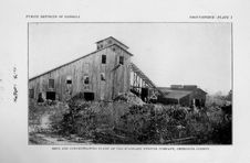
l\1INE AND COKCENTRA'l'ING PLANT OF THE S'I'ANDARD PYRITES COMPANY, CHEROKEE COUNTY.
GEOLOGICAL SURVEY OF GEORGIA
S. W. McCALLIE, State Geologist
BULLETIN NO. 33
A PRELIMINARY REPORT
ON A PART OF
THE PRYITES DEPOSITS
OF
GEORGIA
BY
H. K. SHEARER and J. P. D. HULL,
Assistant State Geologists
Atlanta, Ga. INDEX PRINTING COMPANY
State Printers 1918
THE ADVISORY BOARD
OF THE
Geological Survey of Georgia
IN THE YEAR 1918
(Ex-Officio) His ExcELLENCY, HUGH l\1. DORSEY ........ Governor of Georgia
PRESIDENT OF 'rim BoARD HoN. HENRY B. S'l'RANGE ................... Secretary of State RoN. W. J. SPEER ............................. State Treasurer RoN. W. A. WRIGHT ....................... Comptroller-General RoN. CLIB'FORD WALKER ................... Attorney-General RoN. J. J. BROWN .................. Commissioner of Agriculture HoN. M. L. BRITTAIN . . . . . . . . . . . . Commissioner of Public Schools
LETTER OF TRANSMITIAL
GEOLOGICAL SuRVEY OF GEORGIA,
ATLANTA, MAY 20, 1918. To His Excellency, HuGH M. DORSEY, Governor and President of the
Advisory Board of the Geological Survey of Georgia. SIR: I have the honor to transmit herewith the report of Messrs. .H. K. Shearer and J. P. D. Hull, Assistant State Geologists, on a part of the Pyrite Deposits of Georgia, to be published as Bulletin No. 33, of this Survey. It is confidently expected that the publication of this report at the present time will materially stimulate the production of pyrite, which mineral is now so essential for the manufacture of fertilizers and explosives.
I would here add that the Survey is under many obligations to Mr. Fuller E. Callaway, of LaGrange, Georgia, who at the suggestion of Secretary Lane, of the Department of the Interior, has done much toward speeding up the pyrites industry of the State.
Very respectfully, S. W. McCALLIE, State Geologist.
TABLE OF CONTENTS
ADVISORY BOARD ...............................
LETTER OF TRANSliiTTAL .......................
TABLE OF CONTENTS ...........
LIST OF ILLUSTRATIONS ..... , , ,
INTRODUCTION .....................................
PYRITE ...............................
Production and imports ......................................... . Uses .......................................................... .
HisTORICAL .............................
GENERAL GEOLOGY OF NORTH GEORGIA ............................
The crystalline area ............................................. . Rock formations .............................................. . Carolina gneiss ............................................. . Roan gneiss ................................................ . Granite ............................................ . .. . Other intrusions ............................................ . Metamorphism ................................................ . Physiography ................................................. .
The semi-crystalline area ........................................ . Rock formations .............................................. . Great Smoky formation ..................................... . Igneous rocks ............................................... . Metamorphism ................................................ . Physiography ................................................ .
Structure ...................................................... . Geologic history ................................................ .
PYRITE DEPOSITS .....................
Type~ of deposits ............................................... . Metamorphosed pyrite veins .................................... . Limestone replacements ........................................ . Pyrrhotite veins .............................................. . Disseminated deposits ......................................... .
Distribution of deposits ......................................... . Carroll County belt ............................................ . Draketown district .......................................... .. Villa Rica belt ..................................... Pauliling County belt .................................. Creighton-Dahlonega belt .............................. .
PAG-E
iii iv v-x xi-vii 1-2 2-6 3-5 5-6 7-8 8-20 8-14 8-12 9-10 10-11 11 11-12
1~
12-14 14-18 15-16 15-16
16 16-17 11-18 18-19
19-~0
21-224 21-24 21-23 23-24 24 24 24-31 25 26 27 2i-28 28-29
v
TABLE OF CONTENTS.
PAGE
Ducktown district ............................................. .
29
Isolated deposits ......................................... : .... .
31
Description of individual deposits ............................... 31-224
Carroll County ................................................ . 31-62
Hearn-McConnell prospect ................................... . 32-33
Mount Zion prospect ........................................ . 33-35
Cox property ............................................... . 35-38
Reeds Mountain ............................................ . 38-51
General statement ......................................... . 38-39
Topographic relations ..................................... .
39
Geology ................................................. . 40-44
Ore deposits .............................................. . 44-46
Character of ore .......................................... . 46-48
Surface alteration ........................................ . 49-50
Development ............................................. 50-51
Future of the mine ....................................... .
51
M. T. Earnest property ...................................... . 51-52
M. A. Heartley prospect ..................................... . 52-54
J. T. Williams property ..................................... . 5455
J. S. Michael prospect ....................................... .
55
Jenny Stone prospect ....................................... . 55-59
A. C. Watkins prospect ...................................... 59-60
Lasseter prospect ........................................... . 60-61
Askew prospect ............................................. .
61
Other prospects ............................................. . 61-62
T. J. Butler prospect ..................................... .
61
John D. Tarpley property ................................. .
61
J. W. Garrett prospect .................................... . 61-62
J. T. McGuire prospect .................................... .
62
W. H. Wilson prospect .................................... .
62
Sam Bagwell property ..................................... .
62
Hulett ................................................... .
62
Haralson County .............................................. . 62-89
W. T. Raburn property ...................................... . 62-63
W. M. Raburn property ..................................... . 64-65
J. Humphrey property ....................................... . 65-66
Jackson-McBride prospect .................................... 66-68
Tallapoosa (Waldrop) mine ................................. . 68-82
General statement ........................................ 68-71
Topographic relations ..................................... . 71-72
Geology .................................................. .
72
Ore deposits .............................................. . 72-74
Character of ore .......................................... . 74-80
Production
81
vi
TABLE OF CONTENTS.
PAGE
Future of the mine ....................................... . 81-82
Smith-11cCandless prospect ................................... . 82-88
Other prospects ............................................. 88-89
Marvin M. Brown property ................................ .
89
R. Robertson prospect .....................................
89
W. J. Speight property ... , ................................ .
89
R. F. Pace property ....................................... .
89
J. G. Blackmon property ................................... .
89
Douglas County ............................................... . 89-99
Keaten-Thomas prospect ..................................... . 89-91
Sulphur 2\iining & Railroad Company mine ..................... . 91-98
General statement ......................................... . 91-92
Topographic relations ..................................... .
92
Geology .................................................. . 92-93
Ore deposits and underground workings ..................... . 93-94
Character of ore .......................................... . 94-96
Surface alteration ........................................ . 96-97
Equipment ............................................... .
97
Production . . . . . . . . . . . . . . . . . . . . . . . . . . . . . . . . . . . . . . . . . . . . . . . . 97-98
Tailings . . . . . . . . . . . . . . . . . . . . . . . . . . . . . . . . . . . . . . . . . . . . . . . . . .
98
Other prospects . . . . . . . . . . . . . . . . . . . . . . . . . . . . . . . . . . . . . . . . . . . . . . 98-99
Paulding County . . . . . . . . . . . . . . . . . . . . . . . . . . . . . . . . . . . . . . . . . . . . . . . 99-136
Swift prospect . . . . . . . . . . . . . . . . . . . . . . . . . . . . . . . . . . . . . . . . . . . . . . 99-102
Helms prospect .............................................. 102-103
McGarrity prospect .......................................... 104-105
Rush-Banks prospect ......................................... 105-110
Little Bob mine ............................................. 110-122
General statement .. . . . . . . . . . . . . . . . . . . . . . . . . . . . . . . . . . . . . . . . . 110
Topographic relations ...................................... 110-112
Geology ................................................... 112-114
Ore deposits and underground workings ...................... 114-116
Character of ore ........................................... 116-120
Equipment and methods . . . . . . . . . . . . . . . . . . . . . . . . . . . . . . . . . . . . 121
Production and future of the mine .......................... 121-122
Mammoth prospect ........................................... 122-124
Shirley mine ................................................. 124-129
General statement . . . . . . . . . . . . . . . . . . . . . . . . . . . . . . . . . . . . . . . . . . 124
Topographic relations ...................................... 125-1~6
Geology ................................................... 126-127
Ore deposits . . . . . . . . . . . . . . . . . . . . . . . . . . . . . . . . . . . . . . . . . . . . . . . 127
Character of ore ........................................... 127-128
Development .............................................. 128-129
Production . . . . . . . . . . . . . . . . . . . . . . . . . . . . . . . . . . . . . . . . . . . . . . . . 129
Future of the mine 0
129
vii
1'ABLE OF CON1'EN1'S.
PAGE
Berg prospect ............................................. 130-132 D. Ragsdale prospect ....................................... 132-133 Coggins and Smith prospect ................................. 133-135 Other prospects .............................................. 135-136 S. 0. Brown property . . . . . . . . . . . . . . . . . . . . . . . . . . . . . . . . . . . . . . 135 W. P. Hutcheson property . . . . . . . . . . . . . . . . . . . . . . . . . . . . . . . . . . 135
C. D. Allgood property . . . . . . . . . . . . . . . . . . . . . . . . . . . . . . . . . . . . . . 136 C. B. McGarity property . . . . . . . . . . . . . . . . . . . . . . . . . . . . . . . . . . . . 136 W. W. Hunt and L. A. Moon prospects . . . . . . . . . . . . . . . . . . . . . 136 N S. Vaughn prospect ................... _.................. 136 Cobb County ................................................. 136-143 Marietta mine .............................................. 136-141 General statement ...................................... _.. 136-137 Topographic relations . . . . . . . . . . . . . . . . . . . . . . . . . . . . . . . . . . . . . . 137 Geology ................................................... 137-138 Ore deposits and underground workings ....... _. . . . . . . . . . . . . . . 138 Character of ore ........................................... 138-139 Equipment ................................................ 139-140 Future of the mine . . . . . . . . . . . . . . . . . . . . . . . . . . . . . . . . . . . . . . . . . 141 C. J. Kamper property ....................................... 141-143 Other prospects . . . . . . . . . . . . . . . . . . . . . . . . . . . . . . . . . . . . . . . . . . . . . . 143 J. J. Kemp property . . . . . . . . . . . . . . . . . . . . . . . . . . . . . . . . . . . . . . . 143 C. G. Wright property . . . . . . . . . . . . . . . . . . . . . . . . . . . . . . . . . . . . . 143 Fulton County ................................................. 143-145 Cash prospect ............................................... 143-145 Cherokee County ............................................... 146-179 Bell-Star mine ............................................... 146-155 General statement .......................................... 146-147 Topographic relations . . . . . . . . . . . . . . . . . . . . . . . . . . . . . . . . . . . . . 147 Geology ................................................... 147-149 Ore deposits and underground workings ...................... 149-152 Character of ore ........................................... 152-153 Development and future of the mine . . . . . . . . . . . . . . . . . . . . . . . . . 153 Rich mine ................................................... 154-160 General statement . . . . . . . . . . . . . . . . . . . . . . . . . . . . . . . . . . . . . . . . . . 154 Topographic relations ............................ : ......... 154-155 Geology ................................................... 155-156 Ore deposit ............................................... 156-157 Character of ore ........................................... 157-159 Future of the mine ........................................ 159-160 Dickerson prospect ........................................... 160-162 Smith prospect .............................................. 162-163 Savilla E. McRae property ................................... 163-164 Standard mine _........... _................................. 164-174
viii
TABLE OF CONTENTS.
PAGE
General statement ......................................... 164-165
Topographic relations and transportation . . . . . . . . . . . . . . . . . . . . . 165
Geology .............................................. 165-169
Ore deposits and underground workings ...................... 169-171
Character of ore ...........................................171-172
Development and methods . . . . . . . . . . . . . . . . . . . . . . . . . . . . . . . . . . . 172
Water power .............................................. 172-174
Production and future of the mine . . . . . . . . . . . . . . . . . . . . . . . . . . 174
Swift mine .................................................. 174-179
General statement .......................................... 174-175
Topographic relations . . . . . . . . . . . . . . . . . . . . . . . . . . . . . . . . . . . . . . 175
Geology ................................................... 175-176
Ore deposits and underground workings ...................... 176-177
Character of ore ........................................... 177-178
Development and methods . . . . . . . . . . . . . . . . . . . . . . . . . . . . . . . . . . . 178
Future of the mine ........................................ 178-179
Forsyth and Dawson Counties .................................. 179-181
J. W. Thompson property .................................... 179-180
The Church, lot .............................................. 180-181
J. F. Shelton property . . . . . . . . . . . . . . . . . . . . . . . . . . . . . . . . . . . . . . . . 181
Lumpkin County ............................................... 181-201
The Chestatee mine .......................................... 182-198
General statement ......................................... 182-183
Topographic relations . . . . . . . . . . . . . . . . . . . . . . . .
183-185
Geology ................................................... 185-187
Structure ................................................. 187-189
Ore deposits and underground workings ...................... 189-193
Character of ore .......................................... 193-196
Development and methods . . . . . . . . . . . . . . . . . . . . . . . . . . . . . . . . . . 196
Water power .............................................. 196-198
Future of the mine . . . . . . . . . . . . . . . . . . . . . . . . . . . . . . . . . . . . . . . . 198
Anderson prospect ........................................... 198-199
Other prospects .............................................. 199-200
Southwest of the Chestatee mine . . . . . . . . . . . . . . . . . . . . . . . . . . . . 199
Turkey HiU ............................................... 199-200
Summerour property . . . . . . . . . . . . . . . . . . . . . . . . . . . . . . . . . . . . . . . . 200
Moore property . . . . . . . . . . . . . . . . . . . . . . . . . . . . . . . . . . . . . . . . . . . . 200
Dahlonega-Ellijay public road . . . . . . . . . . . . . . . . . . . . . . . . . . . . . . 200
White County . . . . . . . . . . . . . . . . . . . . . . . . . . . . . . . . . . . . . . . . . . . . . . . . . 201
Danforth property ..................................... , . . . . . 201
Hall and Banks Counties ....................................... 202-204
Habersham County ............................................. 204-205
Panther Creek prospect ...................................... 204-205
Rabun County ................................................. 205-206
ix
TABLE OF CONTENTS.
PAGE
Tom Coward Gap prospect ................................. 205-206 Towns County ....................................... 206-210
Berrong (Johnson Copper) prospect ........................... 207-208 Ivey Mount prospect ......................................... 208-209 Rich Knob prospect ......................................... 209-210 Fannin County ............................................. 210-220 Mine No. 20 ............................................... 210-215
General statement .................................. : .... 210-211 'l'opographic relations ...................................... 211-212 Geology . . . . . . . . . . . . . . . . . . . . . . . . . . . . . . . . . . . . . . . . . . . . . . . . . . 212 Ore deposits and underground workings .................... 212-213 Character of ore . . . . . . . . . . . . . . . . . . . . . . . . . . . . . . . . . . . . . . . . . . . 214 Development and methods . . . . . . . . . . . . . . . . . . . . . . . . . . . . . . . . . 215 Future of the mine . . . . . . . . . . . . . . . . . . . . . . . . . . . . . . . . . . . . . . . . 215 Mobile mine .............................................. 215-216 Phillips prospect .......................................... 216-217 Sally Jane and Jeptha Patterson prospects ..................... 217-218 Mount Pisgah prospect ...................................... 218-220 Floyd County ................................................. 220-221 Patillo property ............................................. 220-221 Lincoln County ................................................ 222-224 Magruder or Seminole mine ................................. 222-224 TNDEX ......... 225-231
ILLUSTRATIONS
PLATE
I. II.
III.
IV. V.
VI. VII.
VIII. IX.
FACING PAGE
Mine and concentrating plant of the Standard Pyrites Company, Cherokee County .................................... Frontispiece
A. Tunnel in upper pyrite vein, Reeds Mountain, Haralson County. Shows a 10-foot vein of quartz and pyrite with vertical, slickensided wall . . . . . . . . . . . . . . . . . . . . . . . . . . . . . . . . . . . . . . . . . . . . . . . . 38
B. Reeds Mountain pyrite mine, Haralson County. Taken in May, 1913, shortly after work was stopped . . . . . . . . . . . . . . . . . . . . . . . . 38
A. Central of Georgia Railway cut, where gossan has been mined for iron ore, Reeds Mountain, Haralson County . . . . . . . . . . . . . . . . . . 92
B. Sulphur Mining & Railroad Company pyrite mine, Douglas County, showing concentrating plant and dumps of waste rock and tailings . . . . . . . . . . . . . . . . . . . . . . . . . . . . . . . . . . . . . . . . . . . . . . . . . . . . . 92
A. Little Bob pyrite mine, Paulding County. General view, looking southeast . . . . . . . . . . . . . . . . . . . . . . . . . . . . . . . . . . . . . . . . . . . . . . . . . 110
B. Little Bob pyrite mine, Paulding County. Close view of beadframe and picking floor ........... , . . . . . . . . . . . . . . . . . . . . . . . . 110
A. Shirley pyrite mine and concentrating plant, Paulding County. . 124 B. Marietta pyrite mine and concentrating plant, Cobb County .... 124 A. Bell-Star pyrite mine, Cherokee County, showing No. 1 shaft,
boiler bouse, and remains of concentrating plant . . . . . . . . . . . . 146 B. Rich mine, Cherokee County . . . . . . . . . . . . . . . . . . . . . . . . . . . . . . . . . 146 A. Standard Pyrites Company property, Cherokee County. Explora-
tion trench along ' ' East ' ' vein . . . . . . . . . . . . . . . . . . . . . . . . . . . . . 174 B. Swift pyrite mine, Cherokee County, showing boiler house and in-
clined shaft, with rectangular stack to aid ventilation . . . . . . . . . 174 A. Chestatee Pyrites & Chemical Corporation property, Lumpkin
County General view, looking southwest from the dam . . . . . . . 182 B. Chestatee Pyrites & Chemical Corporation property, Lumpkin
County, showing machine shops and dam ................... 182 A. Chestatee Pyrites & Chemical Corporation mine, Lumpkin County,
showing loading bins and mouth of haulage level . . . . . . . . . . . . 196 B. Chestatee Pyrites & Chemical Corporation property, Lumpkin
County, showing power house and bridge over Cbestatee River, 196
FIGURES
PAGE
1. Sketch map showing the distribution of ore zones in the Ducktown district . . . . . . . . . . . . . . . . . . . . . . . . . . . . . . . . . . . . . . . . . . . . . . . . . . . . . . . . . . . . . . 30
2. 'l'opograpbic map of a part of the Reeds Mountain property. . . . . . . . . . . . 40
xi
PLATE
FACING PAGE
3. Plan and section showing the geology in the open cut on the lower pyrite
vein, Reeds Mountain property . . . . . . . . . . . . . . . . . . . . . . . . . . . . . . . . . . . . . . 42
4. Topographic sketch map of the Tallapoosa mine, showing outcrops of ore
bodies . . . . . . . . . . . . . . . . . . . . . . . . . . . . . . . . . . . . . . . . . . . . . . . . . . . . . . . . . . . . 71
5. Sketch map of Little Bob mine and Mammoth prospects ............... 111
6. Topographic sketch map of Shirley mine and Berg prospects . . . . . . . . . . 125
7. Flow sheet, Marietta Mining Company plant ......................... 140
8. Sketch map showing ore deposits and workings of the BellStar mine . . . . 150
[. Longitudinal section of the Rich mine, showing extent of undergrounu
workings . . . . . . . . . . . . . . . . . . . . . . . . . . . . . . . . . . . . . . . . . . . . . . . . . . . . . . . . . . 156
HL Map of the Swift property and a part of the Standard property, showing
mines and pyrite deposits .......................................... 166
11. Standard pyrite deposits. Ore shoots projected on inclined plan in plane
of strike and shaft . . . . . . . . . . . . . . . . . . . . . . . . . . . . . . . . . . . . . . . . . . . . . . . . 168
12. Flow sheet, Standard Pyrites Company plant . . . . . . . . . . . . . . . . . . . . . . . . . 173
13. Map of the property of the Chestatee Pyrites & Chemical Corporation.
1,098 acres . . . . . . . . . . . . . . . . . . . . . . . . . . . . . . . . . . . . . . . . . . . . . . . . . . . . . . . 184
14. Topographic map of a part of the Chestatee property and section on line
of vein outcrop . . . . . . . . . . . . . . . . . . . . . . . . . . . . . . . . . . . . . . . . . . . . . . . . . . . . 184
15. Structure section along flume from dam to power house, north side of
Chestatee River, Chestatee property . . . . . . . . . . . . . . . . . . . . . . . . . . . . . . . . . . 187
16. Horizontal plan of a gneiss outcrop, illu&trating relations of banding and
schistosity . . . . . . . . . . . . . . . . . . . . . . . . . . . . . . . . . . . . . . . . . . . . . . . . . . . . . . . . 188
17. Plan and section of underground workings, Chestatee mine, April, 1918, 191
18. Vertical section through inclined shaft at right angles to the strike, show-
ing form of deposit, Chestatee mine . . . . . . . . . . . . . . . . . . . . . . . . . . . . . . . . 192
19. Flow sheet, Chestatee Pyrites & Chemical Corporation plant . . . . . . . . . . . . 197
20. Sketch of north face of pit on Berrong property, showing form and rela-
tions of gossan . . . . . . . . . . . . . . . . . . . . . . . . . . . . . . . . . . . . . . . . . . . . . . . . . . . 207
MAP 1. Map of northern Georgia showing distribution of pyrite deposits. . . . . . . . 26
xii
PRELIMINARY REPORT ON A PART OF THE PYRITE DEPOSITS OF GEORGIA
INTRODUCTION
The published information relating to the pyrite and copper deposits of Georgia is very meager. The State Survey first took up the work of preparing a detailed report in 1915, and J. E. Brantly, then Assistant State Geologist, spent about two months in 1915 and 1916 in making an examination of the most important deposits. With the increased demand for pyrite and mining activity in 1917, the work was again taken up by the present Assistant State Geologists, H. K. Shearer and J. P. D. Hull, who spent three and three and one-half months, respectively, in field work. Unless otherwise acknowledged all chemical analyses used in this report were made in the laboratory of the Survey by Dr. Edgar Everhart, acting chemist.
This preliminary report is based on the field work already completed, although many of the less important prospects have not yet been examined. It is published at the present time to give information and assistance in stimulating production to supply the immediate need for manufacturing fertilizers and explosives. The deposits are therefore described chiefly from an economic view-point. It is the intention of the Survey to publish a second report in which the less important prospects will be described and the discussion of origin, geology and other features of chiefly scientific interest will be taken up in more detail.
The productive capacity of the Georgia mines and concentrating 'plants has be(m increased greatly during the past year or two. In 1916 only two mines reported production. In 1917 five companiesthe Standard Pyrites Company, the Georgia Mining Company, the Shirley Mining Company, the Sulphur Mining & Railroad Company,
2
GEOLOGICAL SURVEY OF GEORGIA
and the Marietta Mining Company-reported a total production of 23,242 long tons, of which about one-fourth was lump ore. Besides these, the Chestatee Pyrites & Chemical Corporation, the Arizona & Georgia Development Company, and the Southern Pyrites Ore Company, all of which are expected to become important producers during 1918, made small shipments in 1917. There is good reason for believing that during 19'18 thP Georgia pyrite production can be increased to almost ten times thE 1917 rate, provided a little additional capital and a supply of labor can be secured.
PYRITE
Pyrite is one of our most common minerals. It occurs in small quantities, usually in the form of cubic crystals, in many kinds of rocks, both igneous and sedimentary, but only occasionally is it found in sufficient quantity and purity to be of commercial value. .!\lost of the commercial supply is derived from mineral veins or replacements deposited by hot solutions given off from masses of intrusive igneous rock, and such ores frequently carry also valuable .metals, such as gold, copper, lead and zinc.
Pyrite, or iron pyrites, is a disulphide of iron (FeS2), containing theoretically 53.46 per cent sulphur and 46.54 per cent iron. Under the trade name "pyrites" are included various other sulphide minerals, especially marcasite or white iron pyrites (FeS2 ), pyrrhotite or magnetic pyrites (Fe11S12 ), chalcopyrite or copper pyrites (CuFeS2 ), and arsenopyrite or arsenical pyrites (FeAsS).
Commercially, pyrites ores are divided in lump ore and fines. The former, as the name suggests, is massive ore, broken into lumps a half inch or more in diameter, and carrying sufficient sulphur (about 40 per cent) to be self burning when heated to the ignition point in a furnace. The fines are in the form of smaller particles resulting from the breaking of the ore in the process of mining or by crushing for the purpose of separating from worthless minerals by some process of mechanical concentration. Even in the fines a large proportion of extremely fine material, or dust, is undesirable, since
PYRITE DEPOSITS OF GEORGIA
3
it is carried mechanically into the acid chambers and causes trouble. The fines must be burned in specially designed furnaces with mechanical agitation during burning, so they can not be used interchangeably in plants equipped for burning lump ore, and therefore they bring a slightly lower price than the lump.
The percentage of sulphur in the fines depends on the original character of the ore to be concentrated and on the local practice and methods of concentration. Some ores which break readily and concentrate cleanly can be brought to more than 45 per cent sulphur without undue loss of pyrite in the tailings, but with other ores it does not pay to concentrate much more than 40 per cent. Acid manufacturers desire ore of at least 40 per cent grade, and ore that carries less than 35 per cent sulphur is seldom used. At any mine the desirable ratio of concentration depends on the balance between the cost of shipping an additional amount of worthless material and the value of the pyrite wasted with the tailings. Prices for both fines and lump are always quoted per unit of one per cent sulphur per long. ton.
After the sulphur is burned out of the ore the cinder may be treated for the extraction of any gold and copper it contains, or may be nodulized and used as iron ore. Zinc, copper and lead in the ore retain a certain amount of sulphur, which will therefore not be available for making acid. Arsenic and antimony are carried over into the acid chambers with the sulphur fumes, and these elements are highly undesirable in acid for most uses. -Carbonaceous matter, which is not present in pyrites except that from coal beds, produces a dark-colored acid, but this is not objectionable for such uses as fertilizer manufacture.
PRODUCTION AND IMPORTS
The production of pyrite in the United States in 19'16, the latest year for which complete statistics are available, was as follows:
4
GEOLOGICAL SURVEY OF GEORGIA
Pyrites produced in the United States ~n 19161
State
Quantity (long tons)
California Illinois ....................................... . Indiana ...................................... . Ohio ......................................... Virginia ...................................... . Other states a ................................. .
145,762 20,482 772 15,551 148,502 94,487
a Includes Georgia, Missouri, New York, Pennsylvania, South Carolina, South Dakota, Tennessee, and Wisconsin.
Production and imports since 1910 have been as follows:
Pyrites prodtwed and imported into the United States
Year
1910 1911 1912 1913 1914 1915 1916
Domestic production (long tons)
241,612 301,4138 350,928 341,338 336,662 394,124 423,556
Imports (long tons)
803,551 1,006,310
970,785 850,592 1,026,617 964,634 1,244,662
In 1916 Georgia ranked seventh in quantity and fifth in value of
pyrite production. In 1917 the production was 23,242 tons, an in-
~
crease over that of 1916, but in 1918 a much larger production
is expected.
Of the 1916 imports about 150,000 tons came from Canada and
the remainder, almost 1,100,000 tons, from Spain and Portugal. The
Canadian imports may continue to come in, and will probably be
increased, but in 1918 the imports from Spain and Portugal will be
greatly curtailed. According to an order of the War Trade Board,
issued March 23, 1918, the importation of only 125,000 long tons is
to be permitted between April 1 and October 1. The monthly ship-
ments are to be gradually decreased, and after the latter date it is
expected that shipment will be entirely prohibited. Therefore, the
deficiency of about 1,000,000 tons must be made up by increased
s: 1 U. Geol. Survey Mineral Resources for 1916, p. 421, 1918.
PYRITE DEPOSITS OF GEORGIA
5
domestic production and by substitution of sulphur, in order to keep up even the normal pre-war production of sulphuric acid.
USES
The only important use of pyrite is m the manufacture of sulphuric acid. This compound is used in almost all the industries, and its production and price, next after iron and steel production, forms the most reliable barometer of general economic and commercial conditions. Under normal pre-war conditio11s oYer two-thirds of the sulphuric acid produced was used in the manufacture of fertilizers. Under war conditions there is an enormously increased demand, since the acid is used in large quantities in the production of practically all high explosives.
The production of sulphuric acid in the ~Cnited States in 1016, expressed in terms of acid of 50 Baume strength, was 6,642.112 short tons, to which must be added 443,332 tons of acid of streugths higher than 66 Baume, not convertible into acid of 60. 0 E the total 1,347,082 tons of 50 B. acid and 92,802 tons of stronger acid were produced as byproducts at zinc and copper smelters.
It is estimated that between eight and nine million tons of sulphuric acid will be needed in 1918. The production from smelters may be increased somewhat over the 1916 amount, but building new plants to make acid from the fumes would require large investments and would take a great deal of time. It must also be considered that most of the smelters are in the West, far from the principal markets for acid. Therefore, it is probable that about 7,000,000 tons of acid must be made from pyrite and sulphur.
Georgia has a greater number of acid plants than any other State. In 1916 the production reported by thirty plants was 284,447 short tons of 50 B. acid, 44,158 tons of 60 B. acid, and 21,878 tons of 66 B. acid.
The following is a list of the acid plants, possibly including one or two not operating in 1918.
6
GEOLOGICAL SURVEY OF GEORGIA
Sulphuric acid plants in Georgia
Name of piant
Town
1. Tennessee Fertilizer Company........................ Albany
2. Empire State Chemical Company ..................... Athens
3. Armour Fertilizer Works . . . . . . . . . . . . . . . . . . . . . . . . . . . . . Atlanta
4. Furman Farm Improvement Company . . . . . . . . . . . . . . . . . Atlanta
5. Morris Fertilizer Company . . . . . . . . . . . . . . . . . . . . . . . . . . . Atlanta
6. Swift & Company ................................... Atlanta
7. Virginia-Carolina Chemical Company ................. Atlanta
8. &eorgia Chemical Works . . . . . . . . . . . . . . . . . . . . . . . . . . . . . Augusta
9. Blackshear Manufacturing Company .................. Blackshear
10. Mandeville Mills ................................... Carrollton 11. Georgia Fertilizer Company . . . . . . . . . . . . . . . . . . . . . . . . . . Columbus
12. Home Mixture Guano Company ....................... Columbus
13. Virginia-Carolina Chemical Company . . . . . . . . . . . . . . . . . . Columbus
14. Hampton Guano Company ............................ Hampton
15. Swift & Company ................................... LaGrange
16. Cotton States Seed & Fertilizer Company . . . . . . . . . . . . . . Macon
17. F. S. Royster Guano Company ....................... Macon
18. Virginia-Carolina Chemical Company . . . . . . . . . . . . . . . . . . Macon
19. Virginia-Carolina Chemical Company .................. Newnan
20. Pelham Phosphate Company .......................... Pelham
21. Virginia-Carolina Chemical Company . . . . . . . . . . . . . . . . . . Rome
22. Mutual Fertilizer Company ........................... Savannah
23. Phosphate Mining Company .......................... Savannah
24. Reliance Fertilizer Company .......................... Savannah
~5. Savannah Guano Company ............................ Savannah
26. Southern Fertilizer & Chemical Company .............. Savannah
27. Virginia-Carolina Chemical Company .................. Savannah
28. Southern States Phosphate & Fertilizer Company ....... Savannah
29. Georgia Fertilizer & Oil Company . . . . . . . . . . . . . . . . . . . . Valdosta
The total capacity of these plants is approximately 418,000 short tons of acid a year. To operate all plants at full capacity would require over 200,000 tons of pyrite a year. Although it is not likely that this amount will be mined in 1918 the necessary rate of production ought to be reached by the end of the year, and Georgia should aim to supply at least its own acid plants with pyrite in 1919. As there is not sufficient lump ore in sight to supply all the plants, the majority of which are equipped with lump burners, it will be necessary for some plants to change their equipment and to burn :fines.
PYRITE DEPOSITS OF GEORGIA
7
HISTORICAL
The discovery and exploration of the Georgia pyrite veins started with the period of gold mining, about 1830. The early gold miners, however, desired only oxidized ores, and as it was found that the deposits of pure pyrite carry little or no gold, and the gold-bearing veins are largely quartz with relatively small amounts of pyrite, little work was done on the larger pyrite deposits. With the discovery of the Ducktown copper deposits in the late forties a period of extensive prospecting commenced, and continued until the outbreak of the Civil War. During this period pits were sunk on almost all showings of pyrite or gossan in the State, and very few pyrite deposits have been discovered since which do not show traces of the work of the old copper prospectors. But in spite of all the prospecting, the only deposits found rich enough in copper to be worked even on a small scale were the No. 20 and Mobile mines in the Ducktown district and the Canton copper mine, Cherokee County.
During the twenty years following the Civil War some attempts were made to mine copper, but at that time pyrite was not considered as a source of sulphuric acid. In the early eighties the Georgia Chemical Company of Atlanta erected the first pyrite-burning acid plant in the South, and to supply this plant the present Tallapoosa and Little Bob mines were opened. The Atlanta plant was operated only a few years, and in 1890 the only pyrite-burning plant in the United States was a small one at Natrona, Pennsylvania. About that time the price of Sicilian sulphur rose from $22:00 to $36.00 per ton, and many acid plants were equipped to burn pyrite, but only lump burners were used, and the Spanish ore was imported at such a low price that there was little incentive for developing domestic mines.
The first really successful pyrite mine in Georgia was the Villa Rica mine of the Sulphur Mining & Railroad Company, which was opened in 1899 and worked almost continuously until 1917. Between 1905 and 1915 the Southern Star, Reeds Mountain, and the Swift mines were worked, but the price of pyrite at that time was too low to make the operations profitable. The Standard mine has been
8
GEOLOGICAL SURVEY OF GEORGIA
worked continuously since 1913. The other mines now in operation have been developed since the rise in prices of pyrite due to the European War.
GENERAL GEOLOGY OF NORTH GEORGIA
Georgia is made up of four geologic provinces: (1) the crystalline area, the rocks of which are chiefly pre-Cambrian and largely igneous; (2) the semi-crystalline or metamorphosed Paleozoic area, of highly metamorphosed sedimentary rocks, principally of early Cambrian age: (3) the Paleozoic area, of folded but not highly metamorphosed sediments; and (4) the Coastal Plain area, consisting of flat-lying, largely unconsolidated sediments ranging in age from Cretaceous to Recent. As pyrite deppsits of importance occur only in the first two areas, the others will not be further considered here.
THE CRYSTALLINE AREA
The area of ancient crystalline rocks in Georgia forms a belt 100 to 150 miles wide, extending from southwest to northeast across the northern part of the State. Southeast of this belt lies the Coastal Plain area of comparatively recent sediments, and to the northwest is the Paleozoic area, comprising the sixteen northwestern counties wholly or in part.
ROCK FORMATIONS1
The rock formations of the entire crystalline area of Georgia are essentially the same as those which have been mapped in detail by the U. S. Geological Survey for the Ellijay folio and a number of other folios farther northeast, in North Carolina and Tennessee. The formations, in order of relative age are: (1) Carolina gneiss, (2) Roan gneiss, (3) granite and other intrusives.
1 In the following sections on Rock Formations, Physiography, Structure, and Geologic History, the folios of the Geologic Atlas have been used freely, especially the work of LaForge, Lawrence and Phalen, W. C., Geologic Atlas of the United States, Ellijay folio, No. 187, U. S. Geol. Survey, 1913. In many cases the exact language of these folios is incorporated.
PYRITE DEPOSll'S OF GEORGIA
9
Carolina gneiss.-The oldest and most extensive crystallme formation is the Carolina gneiss. The formation is made up of a great series of ~ica schist and gneiss, quartzitic schist, garnet and cyanite schist, schistose conglomerate, and fine-grained granitic gneiss. The rocks of the formation are dominantly light to dark gray in color, and weather to a gray, yellow, or light red sandy soil. Probably the most abundant and characteristic type of rock is a light-colored, strongly banded and cleavable schist or gneiss, composed chiefly of quartz and muscovite, with only minor amounts of biotite and feldspar; but layers of granitic material and veins or lenses of quartz-feldspar-muscovite pegmatite .are of common occurrence. Along the borders of the Roan gneiss areas the Roan and Carolina types are intricately associated, with alternating bands of acid and basic rocks varying from a few inches to a few yards thick, making the drawing of boundary lines impossible except in a generalized way.
In Georgia a large part of the Carolina gneiss is certainly sedimentary, and most of it has such character and composition as might have been derived from sedimentary rocks. Because of the intense folding and the general similarity of the rock over a great area, no reliable estimate of the thickness of the formation can be made. The folding has caused repetition of the beds, thus increasing the apparent thickness, but the original thickness must have been very great.
The Carolina gneiss is the oldest rock formation in the Appalachian and Piedmont provinces of Georgia. It contains no fossils, has been subjected to more than one period of intense metamorphism, anrl is intruded by all the igneous rocks of the area. Therefore, it may he classed as pre-Cambrian in age, although no correlation with the pn~ Cambrian series of other areas is possible. However, besides the ancient rocks properly classed as Carolina gneiss, the crystalline area includes infolded bands and masses of later sediments, such as the narrow belt extending from a point a few miles west of Atlanta to the South Carolina line north of Toccoa, and the quartzite beds making up Pine Mountain in Meriwether County. These belts include quartzites and limestone evidently of much later age than the surrounding rocks,
10
GEOLOGICAL SURVEY OH GEORGIA
and are believed to be of early Paleozoic age, in spite of the lack of fossils. The softer rocks have been so much metamorphosed that their appearance approaches that of the Carolina gneiss, a resemblance which makes discrimination very difficult, and no detailed mapping has been undertaken.
Roan gneiss.-The Roan gneiss in Georgia forms many lenticular or sheet-like masses enclosed in the Carolina gneiss. They range in thickness from a few feet to hundreds of yards, but extensive masses like that at Roan Mountain, North Carolina, from which the formation derives its name, are probably not to be found in Georgia. Due to the folding, the sheets appear in surface plan as curved bands, at many places dividing into branches. The distribution suggests either beds or sill- and dike-like intrusives.
The formation consists of hornblende gneiss and schist and schistose diorite, including bands of hornblende-epidote gneiss, chlorite schist, and biotite schist. 'l'he most common phases consist chiefly of hornblende or hornblende and quartz; although feldspar is abundant in the rock at some localities. The hornblende gneiss also includes many interbanded or interbedded masses of mica gneiss and schist of the same type as the associated Carolina gneiss, but too small to be separately mapped.
The hornblendic beds are dark green to black in color, but the more gneissic phases are banded with light-colored layers of quartz and feldspar. Weathering and decomposition produce a characteristic dark red or chocolate-brown clayey soil. An intermediate stage of weathering is represented by porous, punky, brick-red material, with a tendency to break into rectangular blocks. Such weathered hornblende rock has been appropriately named "brick-bat" by the gold miners of the Dahlonega district.
The Roan gneiss is believed to be dominantly of igneous origin, and intrusive into the Carolina gneiss. The mineral constituents have been entirely rearranged and recrystallized during metamorphism, but the original rock types may have been diorite, gabbro, or andesite. It is remarkable that intrusion should take place in such
PYRITE DEPOSITS OF GEORGIA
11
long and narrow dikes, but the distribution may be explained in part by extensive lava flows. Another possibility to be considered is that the hornblende gneiss may represent, at least in part, highly metamorphosed sedimentary beds of impure limestone or calcareous shale. Such metamorphism is possible, as shown in the Grenville district, Canada, where it is said that "under the influence of invading granite, limestone in some places has been changed into an amphibolite, practically indistinguishable from that produced by the dynamic alteration of intrusive bodies of gabbro found in the same district."'
The age of the Roan gneiss is almost as great as that of the Carolina gneiss, since both have undergone about the same amount of metamorphism.
The Roan gneiss belts are economically important, because they ~arry most of the pyrite, as well as the gold deposits, of the crystalline area.
Granite.-There are many granite masses in the crystalline area of Georgia, varying in extent from narrow strips and small patches to areas extending across many counties. Aside from the granitic phases of the Carolina gneiss, the granites are younger and intrusive into both the Carolina and Roan gneisses. The granite masses, however, differ greatly in character and in relative age, as indicated by the degree of metamorphism. Some, such as the Stone .Mountain mass, are massive and show practically no effects of pressure, others are extremely gneissic. The probable range in age of intrusion is from pre-Cambrian to late Paleozoic.
The granites are not known to contain any pyrite deposits, but many important deposits occur within a fraction of a mile of the borders of some of the large granite masses. Therefore, a genetic relationship may be inferred.
Other intrusives.-There are several other types of intrusive rocks in the crystalline area besides the granites, but they have no apparent relation to the pyrite deposits. The most important are: olivinebearing rocks, pyroxenite, dunite and soapstone, associated with the
1 Adams and Barlow, quoted by Van Hise, C. R. and Leith, C. K., Pre-Cambrian geology of North America: U. S. Geol. Survey Bull. 360, p. 474, 1909.
12
GEOLOGICAL SURVEY OF GEORGIA
Roan gneiss and probably of the same age; pegmatite veins or dikes, probably formed during the periods of granite intrusions; and diabase dikes, which cut all other formations, are not metamorphosed, and were intruded at a comparatively recent period.
METAMORPHISM
Most of the rocks of the crystalline area have been so intensely metamorphosed that their original character and relations are obscured. Practically all of the minerals now present were recrystallized under great pressure, which caused the flattened and elongated minerals, such as mica, chlorite, and hornblende, to form with their longer dimensions parallel, and the ease of fracture both between the grains and along the crystal cleavages within them produces schistosity. The perfection of the schistosity depends on the proportion of original material capable of recrystallization into the platy minerals. Thus fine-grained sedimentary rocks, such as shales, produce highly cleavable schists, while granite or quartzite masses may undergo the same pressure with little change in character.
The Carolina and Roan gneisses show evidence of at least two periods of metamorphism. The first produced complete recrystallization and parallel arrangement of the mineral grains; the second bent and distorted the existing mineral grains and cleavage planes, and where sufficiently intense it developed a secondary or false cleavage crossing that already present. The granite masses, as a rule, show much less evidence of metamorphism. Some have evidently never been altered, others show only one period of metamorphism.
PHYSIOGRAPHY
The area of crystalline rocks in Georgia includes parts of both the Piedmont Plateau and Appalachian Mountain divisions of the Appalachian physiographic province. There is no marked geologic difference between these physiographic divisions, as the rock formations pass unbroken from the Piedmont Plateau up the Blue Ridge escarpment and across the mountainous belt.
PYRITE DEPOSI1'S OF GEORGIA
13
The greater part of the crystalline area in Georgia is included in the Piedmont Plateau. This is a dissected .peneplain having an altitude from 1,500 to 1,900 feet along the foot of the Blue Ridge escarpment, and sloping gently southeastward to the edge of the Coastal Plain, where the altitude is about 500 feet. The larger rivers have cut their valleys several hundred feet below the level of the old peneplain; and there are occasional monadnocks of more resistant rock, such as Yonah, Stone, and Kennesaw mountains, which were never reduced to the level of the original plain, and still rise 500 feet or more above its surface. Locally, as in northern Paulding County and along the Tallulah and Tugaloo valleys, the topography is rugged and broken, with steep slopes and narrow valleys, but over much of the Piedmont the elevations are softened and rounded so that almost all the land is arable.
The drainage of the Piedmont flows into the Atlantic Ocean and the Gulf of Mexico through the Savannah, Ogeechee, Apalachicola and Mobile systems. The larger streams within the Piedmont area have fairly uniform grades, but a great deal of water power can be developed by means of storage dams. The most favorable situations for power plants are near the foot of the mountains and along the Fall Line, at which points the stream grades are steeper than in the intervening area.
The entire Piedmont area is well populated and supplied with railroads so that few points are as much as 20 miles from rail transportation.. The building of railroads to any point presents no great difficulty. Very few hard-surfaced wagon roads have been built outside the vicinity of Atlanta, and the clay and top soil roads, while very good in dry weather, are almost impassible for heavy traffic in winter.
The portion of the crystalline area of Georgia included in t.he Appalachian Mountains division takes in the three northeastern counties, Rabun, Towns, and Union, together with parts of several other counties, and extends about 35 miles south of the State line into Pickens County. This area includes a part of the Blue Ridge, which
14
GEOLOGICAL SURVEY OF GEORGIA
is the divide between the 'l'ennessee-Mississippi drainage basin and the rivers flowing more directly into the Gulf and the Atlantic. The southeast slope of the ridge, throughout most of its extent in Georgia, is a steep escarpment leading down to the Piedmont Plateau. The crest of the ridge varies for the most part between 3,000 and 4,000 feet in altitude, culminating in Rabun Bald, 4,717 feet. Northwest of the ridge there is no definite escarpment, but the whole surface is mountainous, with irregular peaks and masses of mountains rising to about the same height as the Blue Ridge summits, and separated by deep, narrow valleys. Brasstown Bald, 4,768 feet, the highest summit in Georgia, is several miles north of the divide.
The Appalachian Mountains area, as a whole, is sparsely settled, because the only localities suitable for cultivation are the narrow valleys north of the Blue Ridge. Two railroads, the Marietta and Etowah line of the Louisville & Nashville system, and the Tallulah Falls Railroad, cross the divide, but the area about 50 miles wide between these lines is not supplied with railroad transportation, and construction would be difficult and expensive. Therefore, the development of mineral deposits is limited.
THE SEMI-CRYSTALLINE AREA
The semi-crystalline rocks of Georgia form a belt from 2 to 30 miles in width along the northwestern margin of the crystalline area. These rocks belong to the Ocoee group of Safford,1 and were long regarded as of Algonkian age. However, fossils of Lower Cambrian age are found as far down as the middle of this group of strata in Tennessee and North Carolina, and the strata below the fossil-bearing beds are conformable and not materially different in character. Therefore, on evidence gathered principally in the Nantahala, Knoxville, Mount Guyot, Asheville, and Roan Mountain quadrangles in Tennessee and North Carolina, the entire group is now assigned to the Cambrian.
1 Safford, J. M., Geology of Tennessee, 1869.
PYRITE DEPOSITS OF GEORGIA
15
ROCK FORMATIONS
The formations of the semi-crystalline area, as mapped in the Ellijay folio, the only quadrangle in Georgia where they have been studied in detail, are as follows: (1) Great Smoky formation; (2) Nantahala slate; (3) Tusquitee quartzite; (4) Brasstown schist; (5) Valleytown formation; (6) Murphy marble; (7) Andrews schist; and (8) Nottely quartzite. Of these the Great Smoky formation covers the greatest area and is the only one in which pyrite deposits are known to occur, so the others need not be discussed here.
Great Smoky formation.-In the Ellijay quadrangle the Great Smoky formation contains a variety of rocks, including conglomerate, graywacke, sandstone, quartzite, slate, mica schist, garnet schist, graphitic schist, staurolite gneiss, and biotite gneiss. The formation also contains limestone beds or lentils, seen underground in some of the Ducktown copper mines, although not exposed at the surface. The entire formation is of sedimentary origin, but some of the graywacke has been reconstructed by metamorphism into the semblance of igneous rock.
The Great Smoky formation shows a decided change in character from northeast to southwest within the Ellijay quadrangle. Near the Tennessee and North Carolina line conglomerates and other coarse sediments form prominent members, but south of Ellijay the sediments were originally finer grained, and have been more intensely metamorphosed. Southwest of this quadrangle intensely metamorphosed, fine-grained sediments are even more prominent. Several of the higher formations of the Ocoee group disappear toward the southwest within the Ellijay quadrangle. In the Suwanee quadrangle, adjoining the Ellijay on the south, the Murphy marble is still prominent, and is extensively quarried at Tate, but farther southwest the entire Ocoee group is uniformly heterogeneous in character, without any distinctive and persistent beds. Therefore, all may be assigned to the Great Smoky formation, at least until detailed mapping is undertaken.
16
GEOLOGICAL SURVEY OF GEORGIA
The thickness of the Great Smoky formation is estimated by La Forge to be 6,000 to 6,500 feet in the Ellijay quadrangle. Southwestward the belt of outcrop narrows, and the formation may become somewhat thinner, but it is evidently of great thickness where it crosses the Alabama line, from Polk, Haralson, and Carroll counties, Georgia.
Igne01ts rocks.-Masses of igneous rock, intrusive into the metamorphosed Paleozoic, are few and scattered, although quartz veins are abundant. In the northwestern part of the Ellijay quadrangle are several dikes of gabbro-like rock which may be genetically related to the Ducktown copper deposits. Similar dikes occur in the Dalton quadrangle, but none are definitely known farther southwest.
The Corbin granite mass in Bartow and Cherokee counties is surrounded by metamorphosed Paleozoic rocks, but is older, and probably formed an island at the beginning of Cambrian deposition.
METAMORPHISM
The rocks of the Ocoee group in Georgia have been greatly metamorphosed, and most of the less resistant beds have been entirely recrystallized. Even in the more quartzitic phases secondary s~ricite has been developed in sufficient quantity to produce schistosity. The beds of graywacke, which were deposited with many unaltered mineral grains from igneous rocks, have been recrystallized, so that nearly all trace of sedimentary origin is lost. The originally clayey and shaly sediments have gone over almost entirely into mica and chlorite. The development of secondary, porphyritic crystals of staurolite, garnet and biotite is characteristic of some beds. Such crystals wer11 formed while the rock was still under great pressure, but after movement had ceased, so they do not show the dimensional parallelism of the schistose minerals.
_\s with the Carolina gneiss, some of the Great Smoky rocks show evidence of two periods of dynamic metamorphism. The first produced schistosity and obliterated almost all trace of bedding planes. The second bent and wrinkled the original planes of schistosity and
PrRITE DEPOSITS OF GEORGIA
17
locally produced a secondary or false cleavage crossing the original cleavage.
Along the eastern margin of the Great Smoky area, and especially southwest of the Ellijay quadrangle, the metamorphism has been especially intense, and the Paleozoic rock is represented by coarse mica schist of almost the same character as the Carolina gneiss with which it is in contact. Where conglomerate beds at the base of the Great Smoky formation and igneous intrusives in the Carolina gneiss are absent the contact can only be drawn as an arbitrary line; and it is probable that Paleozoic beds of considerable extent occur in the northwestern part of the area classed as Carolina gneiss.
PHYSIOGRAPHY
The semi-crystalline, like the crystalline area, indudes parts of both the Piedmont Plateau- and Appalachian Mountains physiographic divisions, bnt its northwestern border, the Cartersville fault, is the boundary of the Appalachian Valley physiographic division, which is underlain by little-metamorphosed Palezoic rocks.
The semi-crystalline area of the Piedmont Plateau includes the most rugged portions of that division. '!'he resistant rocks of the Great Smoky formation in Polk and Haralson counties form Dugdown Mountain, the divide between the Tallapoosa and Coosa drainage systems, with a steep northward-facing escarpment more than 300 feet high. The area for some miles southeast of a line from Rockmart through Cartersville to Fairmount has very broken topography, and includes Pine Log and Sharp Top mountains.
In the Appalachian ::\Iountains division the semi-crystalline rocks, chiefly of the Great Smoky formation, make up the Cohutta Mountains and the small part of the Blue Ridge northwest of the tmvn of Blue Ridge, reaching a maximum elevation in Georgia in Cowpen Mountain, 4,137 feet. The mountains of the semi-crystalline area are, therefore, almost as high, and fully as rugged, as those of the crystalline area. \Vest of the Cohutta Mountains is an escarpment
18
GEOLOGICAL SURVEY OF GEORGIA
more than 2,000 feet high, sloping abruptly down to the Appalachian Valley, without any intervening piedmont area.
This mountain area is sparsely settled and without railroads, but two lines of the Louisville & Nashville Railroad pass along the valleys to the east and west.
STRUCTURE
The crystalline and semi-crystalline areas of Georgia have the common types of Appalachian structure, characterized by folding and faulting on a large scale. At several periods great pressure acted from the old continental mass which existed at the southeast, crumpling the originally horizontal beds into folds of all magnitudes, varying from plications of microscopic size to great anticlines and synclines hundreds of miles in length. Where the stress became too great for the rocks to yield by folding they parted along planes parallel to the axes of the folds, and great thicknesses of rock were thrust northwestward over the younger formations. The movement along single fault planes may be measured by miles, and the total shortening of the earth's crust in this area must have amounted to many miles.
In the area of Paleozoic rocks the structure can generally be determined by tracing distinctive beds. Most of the folds are so closely compressed that the strata on both limbs are nearly parallel, and the attitude of the beds is nearly vertical. Many folds are overturned, so that all strata dip to the southeast. The fault planes also dip to the southeast, and the faults of greatest throw have very low angles of dip.' The Cartersville fault, marking the northwestern boundary of the semi-crystalline area, extends over 100 miles across Georgia and far into Alabama and Tennessee. Several important faults, of which the Murphy and Whitestone faults are the longest, occur near the line between the crystalline and semi-crystalline areas.
In the crystalline area the folding and faulting has certainly been
1 Chamberlin, R. T. and Miller, IV. Z., Low angle faulting Jour Geol vol 26
no. 1, pp. 1-44, 1918.
,
PYRITE DEPOSITS OF GEORGIA
19
as great as in the Paleozoic, but it has been found impossible to work out the structure in so much detail on account of the large, irregular masses of igneous rock, lack of distinctive sedimentary beds, and prevalence of metamorphic structures. The prevailing dip of the schistosity and banding is southeast, generally at high angles,-30 to 90. There arc, however, some areas of many square miles where the dip is to the northeast, due to warping or cross-folding of the original structures. Dips to northwest or southwest are unusual.
GEOLOGIC HISTORY'
The earliest event recorded in the crystalline rocks of Georgia is the deposition of the sediments now forming a part of the Carolina gneiss. The source of the material is not known. A long period of deposition was followed by uplift of the land and intrusion of the granitic material of the Carolina gneiss and the basic rocks now forming the Roan gneiss. One or more periods of intense metamorphism occurred in pre-Cambrian time, and the periods of erosion lasted until deep-seated igneous rocks were exposed.
Early in Cambrian time the Appalachian region sank and the sea intruded from the northwest, while a continental mass remained at the southeast, probably extending far beyond the present Atlantic Coast line. Deposition started with beds of gravel and sand, then under changing conditions alternating deposits, which have smce been changed to conglomerate, sandstone or quartzite, shale, slate or schist, and limestone or marble, were laid down. The maximum extent of the early Cambrian sea to the southeast can not be determined, but it is probable that the greater part of the present crystalline area was under water. In later Cambrian time the shore line probably withdrew to the northwest, as there is no record of depo,;I t,; later than Lower Cambrian east of the Appalachian Valley. Periods of uplift took place in the Ordovician, Silurian and Devonian periods, during which the earlier metamorphic structures in the semi-crystalline rocks were produced.
1 Ellijay folio No. 187, L". s. GeoL SurveY, 1~1R.
20
GEOLOGICAL SURVEY OF GEORGIA
During most of the Paleozoic time after the early Cambrian the history of the crystalline area is a blank, except for the intrusion of igneous rocks. The time of intrusion is not certainly known, but there is reason to believe that some of the large granite masses and associated pegmatite veins are of Carboniferous age. The gold and pyrite veins of the crystalline area occur along the borders of the granite masses, and were evidently deposited by solutions given off from the cooling magmas. Internal evidence in the ores also points to the conclusion that the deposits were formed after the first great period or periods of regional metamorphism, but before the postCarboniferous disturbance. The Ducktown copper deposits, replacing limestones of Cambrian age, may therefore have been formed at approximately the same time as the ore deposits in the older crystalline rocks.
Near the close of the Carboniferous period uplift and compression were renewed, the force, as in earlier periods, acting from the southeast. During this period of metamorphism the rocks were evidently not so deeply buried as previously. Therefore the development of cleavage and other metamorphic structures was not so profound, but the stress was relieved by the formation of the close folds and great faults now visible. This deformation resulted in the final withdrawal of the sea from the entire Appalachian province and the upheaval of a great mountain system.
The Mesozoic and Cenozoic eras were uneventful in the crystalline area, except for the intrusion of diabase dikes and possibly some granite masses, which have no apparent relation to ore deposits. Periods of quiescence and uplift with warping caused the formatibn and dissection of several peneplains, thus controlling the present topography, but the metamorphic effects recorded in the rocks are slight. The most important event was the formation, in pre-Cretaceous time, of the Cumberland peneplain, whose remnants now make up the Piedmont Plateau; and the subsequent uplift and dissection of this plain.
PYRITE DEPOSITS OF GEORGIA
21
PYRITE DEPOSITS
TYPES OF DEPOSITS
The pyrite deposits of Georgia show great variations in character of ore and associated rocks. It is believed that all may be classified under four general types, as follows: (1) metamorphosed pyrite veins, generally associated with Roan gneiss; (2) limestone replacements (Ducktown type); (3) pyrrhotite veins; and (4) disseminated deposits in basic rocks. Deposits of the first two types only are known to be of commercial importance.
METAMORPHOSED PYRITE VEINS
Most of the commercially important pyrite deposits outside the Ducktown area are of the metamorphosed vein type. 'l'he principal area of distribution is along a belt about 10 miles wide and 150 miles long, extending northeast across the State from Carroll to Rabun County; but a few isolated deposits occur outside this belt. The deposits near Bremen, Villa Rica, Hiram, Marietta, Creighton, and Dahlonega, all belong to this class; and those of Towns and Rabun counties are apparently of the same character, although they have not been studied enough to warrant definite statements.
These pyrite deposits are associated with the gold-bearing belts,' but as the workable pyrite deposits are much less numerous than the gold deposits, the belts can not be mapped so continuously. The distribution is not quite the same, since some of the best pyrite deposits occur in the area between the Dahlonega and Carroll County gold belts, as mapped by Jones. It has also been found that the richest gold veins consist of quartz with very little pyrite, but the massive pyrite veins carry little or no gold.
The association of pyrite deposits with the hornblendic rock of the Roan gneiss formation is notable. All of the deposits of this type
1 Yeates, W. S., McCallie, S. W., and King, F. P., Preliminary report on a part 0f the gold deposits of Georgia: Geol. Survey of Ga. Bull. 4-A, 542 pp., 1896.
GaJ.onBeusl,l.
S. P., Second 19, 283 pp.,
report 1909.
on
the
gold
deposits
of
Georgia:
Geol. Survey of
22
GEOLOGICAL SURVEY OF GEORGIA
which have been worked are in belts of Roan gneiss, although the immediate wall rock of the veins may be biotite or chlorite schist. Some of these belts, with workable pyrite deposits at intervals, extend for a number of miles and are locally known as ''pyrite leads,'' which term is used in this report. Outcrops are not common in the Piedmont area, so the surface indications are belts of dark red soil and "brick-bat." Although occurring in the belts of hornblende gneiss, the pyrite deposits are generally within a fraction of a mile of the border of one of the intrusive masses of granite gneiss. Thus, a number of the most important deposits of both gold and pyrite are found along the northwest border of a great mass of granite gneiss which extends almost continuously from the vicinity of Villa Rica, Carroll County, northeastward to Rabun County.
The deposits of this type appear to have been formed as simple veins or along sheared zones, with more or less replacement of the wall rock. On account of the subsequent crushing and re-crystallization the typical vein structures, such as crustification, banding, and open cavities have almost entirely disappeared, and the deposits have been crushed into approximate conformity with the schistosity of the wall rock.
The principal vein mineral is pyrite, with pyrrhotite, chalcopyrite, sphalerite, and magnetite in suborqinate quantities, where present at all. The most abundant gangue minerals are quartz, chlorite, calcite, and garnet. Although calcite is abundant at some places, both in the veins and in the wall rock, no limestone has been found in any of these deposits, and the heavy calcium-bearing silicate minerals which indjcate limestone replacement are lacking.
The hornblende gneiss at some places, notably near Hiram, is interbedded with quartzitic sericite schists of undoubted sedimentary or1gm. The relations are obscure, but in such areas the igneous origin of the Roan gneiss is very doubtful. The composition of the gneiss is such that it could have been formed by metamorphism of beds of calcareous shale.
The age of the deposits can not be determined very definitely.
PYRITE DEPOSITS OF GEORGIA
23
Both pyrite and gold-quartz veins must have been deposited by solutions given off at different stages during the cooling of the intrusive granite magmas. The granites range in age from pre-Cambrian to late Paleozok and the masses with which most of the pyrite deposits are associated appear to be of comparatively late age, although they have been rendered gneissic by the post-Carboniferous uplift, the last period of great regional metamorphism. It is thought that extensive intrusion of granite took place during the Carboniferous period, which may be assigned as the most probable age of the pyrite de-
posits.
LIMESTONE REPLACEMENTS
Limestone replacement deposits in Georgia occur only in the metamorphosed Paleozoic rocks (Great Smoky formation), and include those of the Ducktown area, the Tallapoosa mine, and probably the Rich mine.
The genesis of the Ducktown ores has been discussed by Emmons and Laney.' Briefly, the ores consist of pyrrhotite, pyrite, chalcopyrite, sphalerite, bornite, specularite, magnetite, actinolite, calcite, tremolite, quartz, pyroxene, garnet, zoisite, chlorite, mica, graphite, titanite, and feldspar. The texture of ore, relation to country rock, and association of minerals indicate replacement of limestone by magmatic waters at considerable depth, and remnants of crystalized limestone are found in some of the mines. The rocks were apparently intensely metamorphosed before the period of mineralization, but some deformation has occurred since. Therefore the deposits must have been formed Home time between the close of the Cambrian period and the post-Carboniferous uplift, and their age may be about the same as that of the pyrite veins of the crystalline area.
At the Tallapoosa mine the ore replaces limestone, some of which remains in the deposit. 'l'he underground workings of the Rich mine could not be examined, but limestone occurs in the vicinity, and the
/ Emmons, W. H. and Laney, F. B., Preliminary report on the mineral deposits o Ducktown, Tennessee: U. S. Geol. Survey Bull. 470, pp. 161-172, 1911.
24
GEOLOGICAL SURVEY OF GEORGIA
deposit is probably a replacement. These deposits occur in rocks of about the same age as the Ducktown deposits, but the type of ore is quite different, being made up largely of pyrite instead of pyrrhotite.
PYRRHOTITE VEINS
Small veins of pyrrhotite, or pyrrhotite and quartz, occur at a number of places in the metamorphosed Paleozoic rocks. The largest known is the Panther Creek prospect, Habersham County, in the belt of Paleozoic rocks extending northeast from Atlanta. Others occur in Pickens and Gilmer counties, near Whitestone and Cherrylog. These have no apparent commercial value, since all deposits are small, and the sulphur content of pyrrhotite is so low that it will probably not be in demand as long as pyrite is available.
DISSEMINATED DEPOSITS
The belt of pyrite-bearing hornblende, epidote and chlorite gneiss m Hall and Banks counties belongs to a type which can only be classified as disseminated deposits in basic rocks. Rock of similar character has been found in eastern White County. 'rhese belts contain great masses of rock with perhaps 10 per cent pyrite, but they are not likely to be worked while pyrite can be obtained from richer deposits.
DISTRIBUTION OF DEPOSITS
The pyrite deposits of Georgia occur principally in one irregular belt across the State, but for purpose of description the best prospects and active mines may be grouped partly according to geographic position and partly according to geologic relation, in six districts, namely : (1) the Carroll County belt, (2) the Draketown district, (3) the Villa Rica belt, (4) the Paulding County belt, (5) the Creighton-Dahlonega belt, and (6) the Ducktown district. There are also a few isolated deposits outside these districts.
PYRITE DEPOSITS OF GEORGIA
25
CARROLL COUNTY BELT
The Carroll County pyrite belt is an irregular area about 8 miles wide and 24 miles long, extending from southwestern Carroll County northeastward across a part of Haralson County and terminating near Temple. This belt contains one well-defined pyrite lead about 20 miles long, passing 2 miles east of Bowdon, through Burwell and Mount Zion to Reeds Mountain. Outside of this main lead, the belt includes the Hearn-l\IcConnell prospect in the northwestern part of the county, and the Heartley and Barnest properties near Mandeville, which seem to form the southern termination of a broken lead including Vines :Mountain in Haralson County and some small prospects near Temple. The whole area has a rolling and hilly topography and is well drained by southerly and southwesterly branches to Tallapoosa River.
The pyrite deposits occur in hornblende schist and gneiss or in the more altered schists characterized by mica, chlorite, and sericite. The pyrite deposits of these basic formations are genetically associated with acidic intrusions, such as small pegmatite and granite dikes or more extensive granitic masses. Granite gneiss intrusions occur with the Reeds Mountain deposits, and 'yithin a mile west of the Mount Zion prospect granite gneiss and pegmatite are exposedthe latter cutting across the schistosity of the country rock.
On the northwest side of the main lead and parallel to it a broad belt of pegmatitic and gray mica gneiss extends from Waco, Haralson County, to Bowdon. Within 2 miles southeast of the Vines Mountain prospects, there is an area of gray granite gneiss similar to the Villa Rica granite.
In general, therefore, the rocks of the Carroll County belt include
a country rock of gray Carolina gneiss or schist with narrow belts
of basic hornblende schists containing the pyrite deposits and in proximity to acidic igneus masses-both being cut by pegmatite dikes.
GEOLOGICAL SURVEY OF GEORGIA
DRAKETOWN DISTRICT
The Draketown pyrite district is 10 miles long and 5 miles wide, extending from the vicinity of Draketown, Haralson County, northeastward a few miles beyond Yorkville, Paulding County. The principal lead occupies the northwestern part of this area and is marked by many prospects, chief of which are the Tallapoosa, Smith-McCandless, and Rush-Banks. The southeastern part of the district includes the Swift prospect and several others, notably the Helms prospect, northeast of Embry, but it is not certain that these form a definite lead. The topography of the district varies from gently rolling to sharply dissected. In the southern part, Tallapoosa River flows westward and in the northern part, Pumpkinvine Creek flows toward the northeast.
Two types of pyrite deposits occur in the Draketown district, the limestone-replacement deposit illustrated in the Tallapoosa mine, and the deposits associated with Roan gneiss illustrated in all the other deposits. The red clay loam of the hornblende gneiss is also a feature of the Tallapoosa deposit, but this ore body is the only one in the district where limestone has been observed.
The western lead follows the general line of contact between metamorphosed Paleozoic rocks and the ancient crystalline formations. It is clearly marked by the red soil strip of decomposed hornblende schist, immediately flanked in many places by garnetiferous schist and at a short distance by magnetitic and manganiferous quartzite. These narrow parallel strips are especiaU-v well seen at the SmithMcCandless prospect.
The rocks between Draketown and the Swift property show scarcely any sedimentary characteristics. They are largely metamorphic basic rocks resembling diorite and producing a broad area of red clay loam.
The Draketown district is made up of one definite pyrite lead in the western part following the hornblende schist and the border of the metamorphosed sediments, and more isolated deposits in the eastern part, which are also in hornblende and chlorite schist.
83"
L
N A
.:I
MAP
OF
NORTHERN GEORGIA
SHOWING DISTRIBUTION OF
PYRITE DEPOSITS
Base Map by the U. S. Geological Survey Scale 1:1,000,000
1 inch-approximately 16 miles
I. Carroll County Belt 2. Draketown D istrict 3. Vilfa Rica Bell 4. Pauldiog County Bell S. Creigbtoo.Dahlonega Belt 6. Ducktown District
e PYRIT E MINES x PYRITE PROSPECTS
PYRITE DEPOSITS OF GEORGIA
27
VILLA RICA BELT
The Villa Rica pyrite belt is one distinct lead 5 miles long and a few hundred yards wide, extending from Little Tallapoosa River, 3 miles west of Villa Rica, Carroll County, northeastward in a gently curving arc north of Old Villa Rica and a mile or more beyond the Sulphur Mining & Railroad Company mine in Douglas County. This belt has been prospected at frequent intervals along its whole length. Besides the mine of the Sulphur Mining & Railroad Company, the most promising prospect is the Jenny Stone. The rolling surface of the belt is drained toward the southwest by Little Tallapoosa River and toward the northeast by Sweetwater Creek.
The ore deposits are in a narrow formation of hornblende schist and gneiss near the contact with biotite granite gneiss, which forms a large and distinct mass, extending several miles eastward. There is also a granitic area bordering the hornblendic formation on the northwest. At either end of the pyrite lead, the ore gradually gives way to richly garnetiferous schist. The close contact of the pyritiferous basic rock with the acidic mass of the Villa Rica belt shows as clearly as in any of the pyrite districts the influence of the igneous rock in the genesis of the ores.
PAULDING COUNTY BELT
The Paulding County pyrite belt covers an area 8 miles long and 2 miles wide. The southwestern end is half way between Hiram and Dallas in Paulding County and the northeastern end is south of Lost Mountain in Cobb County. The belt is made up of two smaller belts as defined by the different prospect leads. The western belt contains the Shirley, Liberty, and Coggins and Smith properties. The eastern belt is the longer of the two and includes the Little Bob mine, Mammoth prospect and, farther toward the northeast, the Ragsdale and other prospects south of Lost Mountain. The area is hilly and drained toward the southeast by Powder Spring Creek and its branches.
The Paulding County belt follows the red soil of the altered
28
GEOLOGICAL SURVEY OF GEORGIA
Roan gneiss formation, of which the chief members are hornblende, mica, chlorite, sericite and epidote schists. Quartzite with hornblende needles and calcite crystals is common, and the sedimentary appearance of parts of the formation is pronounced. South of the Little Bob mine, garnet schist is abundant and seems to form the termination of the pyrite deposit. Within a mile either side of the pyrite bellt there are masses of granite gneiss, and still nearer the ore deposits there are small granitic bodies interbanded with the schists. Both Hiram and Dallas are in areas of granite gneiss.
CREIGHTON-DAHLONEGA BELT
The Creighton-Dahlonega belt is the name given to a pyritiferous zone 4 miles wide in places and at least 60 miles long, stretching in a northeast direction from Holly Springs, Cherokee County, across the northwest corner of Forsyth County, through Dawson County east of Dawsonville, Lumpkin County east of Dahlonega, and into White County north of Cleveland. This long belt is more or less continuous, but it includes several pyrite leads and different types of deposits. It is identical with part of the Dahlonega gold belt but is not so extensive. At Creighton, Cherokee County, the Swift prospect and the Standard mine are northwest of the Franklin gold mine; in Dawson County, the pyrite prospects are largely identical with gold prospects; and in Lumpkin County the pyrite lead passes east of the Dahlonega gold fields. As a rule, the workable gold occurs with quartz stringers in mica schist, without profitable amounts of pyrite, whereas the workable pyrite deposits generally occur in hornblende schist with little or no gold.
Several of the pyrite deposits at the southern end of the Creighton-Dahlonega belt are in metamorphosed Paleozoic schists. The Rich mine, one mile south of Canton, Cherokee County, is in a limestone-replacement deposit, but because of its geographical proximity to the Creighton deposits in hornblende gneiss it has been grouped with them. Along the eastern side of the belt, lies a large mass of granite gneiss which strongly suggests the origin of the ore to be
PYRITE DEPOSITS OF GEORGIA
29
from rich mineral solutions of the igneous mass. 'rhis acid gneiss is exposed within a mile of the Standard mine at Ceeighton, Cherokee County, and the Chestatee mine in Lumpkin County, and is distinctive as marking the eastern boundary of the whole basic belt of Roan gneiss.
In the metamorphic Paleozoic formation, particularly at the Rich mine, are garnet, cyanite, carbonaceous, and calcareous schists asSO ciated with the more common mica schists. The greater portion of the belt, however, is composed of ancient crystalline mica schists, also associated with garnetiferous members, enclosing the hornblendic pyrite-bearing belt at the contru~t with the granite gneiss.
DUCKTOWN DISTRICT
The deposits of the Ducktown District are included in an area 6 miles long and 4 miles wide. The greater part of the belt is in Tennessee, but it extends about 2 miles into Fannin County, Georgia. The No. 20 and Mobile deposits are the most important in the Georgia part of the district. 'l'he 1\'Iount Pisgah prospect, though only a few miles from the others, is of a different type and can not properly be included in the Ducktown District. The deposits occur in several leads, representing replacements of one or more limestone beds infolded with the graywacke and mica schist which form the country rock. The distribution is shown in figure 1, reproduced from the report by Emmons and Laney', and extended to include the Georgia deposits.
1 U. S. Geol. Survey Bull. 470, p. 162, 1910.
30
GEOLOGICAL SURVEY OF GEORGIA
N
,'J Boyd /
,,
Culchofe
TENNESSEE GEORGIA
POI..K. COUNTY FANNIN COUNTY
Sally Jane,./.!
_/'l'flne flo. eo
D
Graywcke d schi&t
Nobile If''
)'
Sturolitic bed.s
0
3000
bOOO
SCFILE IN FEET
Fig. 1. Sketch map showing the distribution of ore zones in the Ducktown district.
PYRITE DEPOSITS OF GEORGIA
31
ISOLATED DEPOSITS
Several pyrite deposits of importance that could not be included in any of the districts or belts are here grouped as isolated deposits.
'l'he 1\Iarietta mine, 3 miles south of Marietta, Cobb County, is in a red soil area of Roan gneiss not far distant from a biotite granite mass.
The Bell-Star mine, Cherokee Count~-, has a geologic position similar to the Draketown deposits, practieally on the border between the crystalline mass and the metamorphosed Paleozoic rocks. There is no granite in the immediate vicinity, but hornblende gneiss was found underground. Another resemblance to Draketown is the presence of a belt of maganiferous magnetite-quartzite parallel to the pyrite vein.
The Seminole deposit, on the border of Wilkes and Lincoln counties, 12 miles northeast of Washington, Wilkes County, occurs in diabasic dikes cutting gray mica schist. This mine, formerly known as the Magruder mine, was not visited by the writers, but has been described in other bulletins1
The Cash prospect, about a mile south of Ben Hill, Fulton County, is associated with a basic intrusive in a large granite gneiss area.
The Ivey Mount and Berrong prospects in Towns County are on a small isolated lead about 2 miles long and, unlike most other deposits of the State, they occur in an area of Carolina gneiss and no hornblende gneiss nor granite has been found in the vicinity.
The pyrrhotite veins and disseminated pyrite deposits are irregularly distributed and do not follow any of the principal pyrite belts.
DESCRIPTIONS OF INDIVIDUAL DEPOSITS
CARROLL COUNTY
Carroll County lies entirely in the crystalline area of the Piedmont Plateau. Pyrite deposits distributed over the northwestern part of
of1 GJones, S. P., Second report on the gold deposit~ of Georgia. Geol. Survey
2 2 5 B~ata .s
oBn,ullT. .
19, L.,
p
p. 248-254, 1909. The Seminole copper
deposits
of
Georgia.
U. S. Geol. Survey
. ' pp. 182-186, 1903.
32
GEOLOGICAL SURVEY OF GEORGIA
the county are included in the large and irregular Carroll County pyrite belt. The Villa Rica belt, made up of a line of deposits along a single lead, extends about 5 miles into the northeastern corner of this county.
The important Reeds Mountain deposit is on the northern line of Carroll County, and lies partly in Haralson.
HEARNMcCONNELL PROSPECT
(Map locality C-1)
In the northwestern part of Carroll County, 8 or 9 miles northwest of Bowdon and approximately the same distance from Burwell, is the Hearn-McConnell pyrite prospect. Its location by the land survey is lot 40, 9th. district, 5th. section. This property belongs to Mrs. George King, R. F. D. No. 2, Waco, Georgia, who has given an option to J. A. Hearn, of Burwell, and Thomas M. McConnell, of Bowdon. Exploration work was done sometime in the seventies and options have been held by a number of people.
The prospect shaft is at the foot of a steep, wooded hill on the east side of Little Indian Creek, about 200 feet south of the public road a mile west of Kansas, and 7 miles in an air-line north-northwest of Bowdon. It is a small vertical ~ening 27 feet deep in greenishgray chloritic schist which strikes N.50oE and dips 50oSE.
The geologic structure in this vicinity is very irregular; the schistosity shows extreme variations indicative of great disturbance. The pyrite schist is exposed along a distance of 25 feet in the nose of the hill around which the stream bottom curves, cutting off any evidence of a lead in either direction.
Similar to many other prospects, the Hearn-McConnell shaft at the time visited was full of water; ore previously raised, however, is of good lump and milling character. The former consists of fine particles of pyrite with minor quartz and chlorite cementing material; the latter includes both fine and coarse-grained concentrating ore. The analysis of lump and fines together taken from the dump shows
PYRITE DEPOSITS OF GEORGIA
33
good quality, the quantity in the deposit is uncertain. It is reported that a thickness of 3 feet of good ore was cut by the shaft.
Analysis of pyrite ore from the Hearn-JrlcConnell prospect (Hu-188)
Silica (SiO,) and insoluble.. . . . . . . . . . . . . . . . . . . . . . . . . Pcrrir oxide (Fe,O,) . . . . . . . . . . . . . . . . . . . . . . . . . . . . . . . . l\Ioisture . . . . . . . . . . . . . . . . . . . . . . . . . . . . . . . . . . . . . . . . . . Pyrite ( FeS,) . . . . . . . . . . . . . . . . . . . . . . . . . . . . . . . . . . . . . .
11.78 1.12 .07
61.76
Total. . . . . . . . . . . . . . . . . . . . . . . . . . . . . . . . . . . . . . . . 80.73
Iron (Fe) . . . . . . . . . . . . . . . . . . . . . . . . . . . . . . . . . . . . . . . . . Sulphur (S) . . . . . . . . . . . . . . . . . . . . . . . . . . . . . . . . . . . . . . . Copper (Cu) . . . . . . . . . . . . . . . . . . . . . . . . . . . . . . . . . . . . . . Gold (Au) . . . . . . . . . . . . . . . . . . . . . . . . . . . . . . . . . . . . . . . . Silwr (Ag) . . . . . . . . . . . . . . . . . . . . . . . . . . . . . . . . . . . . . . . .
30.18 32.48
.00 .00 .00
Further work on this property has doubtless been discouraged by the unpromising extent of the ore body. The Bowdon Railway, either at Bowdon or at Burwell, is more than 8 miles distant by a road which crosses several rather deep stream valleys.
MOUNT ZION PROSPECT
(Jlap locality C-2)
The Mount Zion pyrite prospect, otherwise known as the Crawford prospect, is on lot 235, lOth district, northwestern part of Carroll County. lHonnt Zion Postoffice is half a mile west-southwest, and the station on the Bowdon Railway is about the same distance south. The agricultural rights belong to JHrs. W. J. Crawford, of Tallapoosa, Georgia, but the mineral rights belong to Ruff, Hartsock & Company, of Atlanta, and W. L. Tumlin, of Tallapoosa.
It has been known for several years that pyrite occurred on this property but very little exploration was done until 1917. At that time a 20-foot shaft was dug and other openings were made along the east side of a small branch flowing northward into Little Turkey Creek. At this point Little Turkey Creek is sharply diverted from its natural southwest trend and for a mile cuts directly across the
34
GEOLOGICAL SURVEY OF GEORGIA
schistosity; it then joins Turkey Creek northwest of Mount Zion and the main south-southwest drainage is resumed.
The low divide which separates the Turkey Creek system on the west from the Buck Creek system on the east, conforms to the schistosity of the rock and the strike of the pyrite deposits, extending from Reeds Mountain southwestward past Mount Zion and beyond Bowdon. Of the many small prospects that have been examined along this lead southwest of Reeds Mountain, the Mount Zion prospect seems the most favorable.
The rock containing the pyrite is well exposed where it makes a little waterfall in the branch 50 or 60 feet south of the shaft. The rock is greenish-gray chloritic schist, somewhat crinkled, striking N.l0E., with a dip 55SE., parallel to the general schistosity. A thickness of 5 feet at this point seems to represent the best part of the vein; it is lean milling ore. The west side, or foot wall, of this lean ore is concealed by the stream ; but the east side, or hanging wall, poorly exposed in the stream bank, is micaceous schist more than 5 feet thick, whose rusty surface decomposition indicates a small content of sulphide. Dark, hornblendic, finely banded gneiss, so characteristic of the pyritiferous red soil belts in the State, is exposed in a number of places on the hanging wall side.
No ore was available from the shaft which was choked with debris, but representative specimens from the vein where it crosses the branch show small, somewhat distorted crystals of pyrite, ranging from -:l-2 to 1j8 inch, and rather uniformly scattered through a gangue of quartz, chlorite, biotite, garnet, and magnetite. The material is schistose and readily crushed. Slightly more than 16 per cent of this ore is pyrite.
Analysis of milling ore frorn the Monnt Zion pyrite prospect (Hu-234)
Silicia (Si02) and insoluble . . . . . . . . . . . . . . . . . . . . . . . . . Ferrie oxide (l'e 20 3 ) Moisture . . . . . . . . . . . . . . . . . . . . . . . . . . . . . . . . . . . . . . . . . .
Pyrite (FeS,) . . . . . . . . . . . . . . . . . . . . . . . . . . . . . . . . . . . . .
72.01 8.20 .12 16.46
Total. . . . . . . . . . . . . . . . . . . . . . . . . . . . . . . . . . . . . . . 96.79
PYRITE DEPOSI1'S OF GEORGIA
35
Iron (Fe) ........................................ . Sulphur (S) ...................................... . Copper (Cu) ..................................... . Gold (A.u) ....................................... . Silver (Ag) ...................................... .
13.40 8.80 .00 .00 .00
The ore lead has been prospected on the Orawford property along a distance of 300 yards, southwest from the bend in Little Turkey Creek. No outcrops of gossan have been found to indicate anything but a very low gradl~ ore.
COX PROPERTY
(Map locality C-3)
A. H. Cox, of Bremen, owns in fee simple 197 acres of land, be sides the mineral rights on 13 acres more, situated in lots 260, 276, and 277, 7th. district, 5th. section, Carroll County.
The property lies about a mile southwest of Reeds Mountain, and includes nearly a mile of the pyrite lead of that deposit, measured along the strike.
The types of rock found on the Cox property include weathered granitic gneiss, coarse mica schist or gneiss, fine-grained quartzsericite schist, chlorite schist, and garnetiferous hornblende gneiss, the latter probably a metamorphosed diorite. The details of the structural geology could not be determined without a great deal of underground work. However, the pyrite lead, consisting of chlorite, hornblende, and quartz-sericite schists, all impregnated with pyrite, crosses the property in a direction approximately N.30E., with an average dip of 45 SE. 'rhe line of strike carries the beds directly through Reeds Mountain. On the Cox property the resistant beds of the pyrite-bearing formations form a ridge locally known as Mandeville Mountain.
On this property no true veins of pyrite have been discovered, but large masses of schist are impregnated with pyrite in small and more or less scattered crystals. Most of this material contains such a small percentage of pyrite that it could not be worked even at the
36
GEOLOGICAL SURVEY OF GEORGIA
present war price, but there are portions rich enough to be classed as low grade concentrating ore. There are a few fragments of ironrich gossan which appear to have been derived from pyrite ore of higher grade, but the source could not be located.
The best exposure on the property is in a trench along the course of a small branch, 300 yards northeast of the Cox residence and in the south-central part of lot 260. The average strike of the cleavage and banding is N.35E., and dip 40SE. The section from northwest to southeast is as follows, the measurements being horizontal distances:
Section in trench on Cox property
Feet 1. Sericite schist containing a little pyrite, and cut by
veinlets of quartz . . . . . . . . . . . . . . . . . . . . . . . . . . . . . . . 40 2. Hard quartz-sericite schist. . . . . . . . . . . . . . . . . . . . . . . . . . 25 3. Hornblende-quartz schist, with minute scattered pyrite
crystals . . . . . . . . . . . . . . . . . . . . . . . . . . . . . . . . . . . . . . . . 30 4. Weathered material, apparently derived from granitic
gneiss, without pyrite . . . . . . . . . . . . . . . . . . . . . . . . . . . 15 5. Concealed interval .............. :-: . . . . . . . . . . . . . . . . . 75 6. Chlorite, biotite and quartz schist with disseminated
pyrite, some layers a few inches thick being rich enough to make good ore. The lower part contains more pyrite, the upper part is more chloritic and contains larger but more scattered pyrite crystals. . . . 60
A sample (S-323) was taken from the lower 5 feet of unit 6 of the preceding section. This represents the richest part of the exposure, and consists of a green chloritic schist with abundant pyrite cubes,
mostly measuring less than ls inch. This shows that there is some
material present which may be classed as ore, but requiring 4 to 1 concentration. As the grade is so low, a deposit much more than 5 feet thick must be found before work on a commercial scale can be undertaken. The complete analysis is as follows:
PYRITE DEPOSITS OF GEORGIA
37
Analysis of pytite ore from Cox property ( S-3.'23)
Constituents
Soluble in aqua regia
Insoluble
i Silica (SiO,) and insoluble .............
Silica (SiO,) ...........................!
Alun~ina _(Al,O,: ....................... I
Ferne oxille (Fe,O:;) ................... .
}fagnesia (lVIgO) ....................... 1
Lime (CaO) .......................... .
Soda (Na,O) .......... . I1
I Potash (K,O) ..
}[oisture ............................. 1
'ritanium dioxide (TiO,) ............... .
I Manganous oxi<lc (J\fnO) ...............
Copper (Cu) .......................... 1 Pyrite (FeS,) ......................... 1
II
Total. ............................
I
Metallic iron (Fe) .................... 1
Sulphur (S) .......................... .
Phosphorus (P) .......................
58.28
4.60 5.34 4.28
.00
.38
.26 .00 26.38
99.ii+
44.64
7.~8
+.84 .34 .00 .15 .:25
.78
16.02 14.10
.07
58.28
1
North of the cut described above, the pyrite lead may be traced by a belt of dark red soil derived from hornblende schist, but thrrc are no openings. To the south of the cut, east of the Cox residence and in Mandeville Mountain, are outcrops of quartzitic schist, in part containing cyanite crystals and cavities left by the vvcathering of small pyrite crystals. There is also an exposure of quartz sericite schist with small pyrite crystals at a higher horizon, in a railroad eut east of the Cox property, but the strike of the beds would carry them through that property.
The property is well situated in regard to transportation. The Chattanooga and Griffin line of the Central of Georgia RaihYay crosses one corner for a distance of a few hundred yards, >Yhich would afford space for a siding and loading station.
Like Reeds Mountain, this property is situated near the summit of
38
GEOLOGICAL SURVEY OF GEORGIA
a divide, so that water supply for working would have to be obtained from small branches, or piped more than a mile from 'furkey Creek.
In conclusion, it may be stated that, while no deposits of pyrite ore of workable size and quality have been discovered on the property, the indications are favorable enough to warrant further prospecting.
REEDS MOUNTAIN
(Map locality 0-4)
General statement.-The Reeds Mountain property consists of lot 246 (202% acres), 7th. district, 5th. section, Haralson County, and 165 acres, more or less, of lot 259, 7th. district, 5th. section, Carroll County, including all of the lot except 37% acres in the southeast c:;orner. The Chattanooga and Griffin line of the Central of Georgia Railway runs through both lots, crossing the outcrop of at least one of the pyrite veins. The nearest town and postoffice is Bremen, Haralson County, population 890 by the 1910 census, situated at the crossing of the Central of Georgia and Southern railways, 1% miles northwest of Reeds Mountain.
The mineral rights on the property are owned by Dr. M. K. Phillips, Bremen, Georgia, and Joseph Kingsbury, Forth Worth, Texas; and leased by the Southern Pyrites Ore Company, 78 Auburn Avenue, Atlanta, Georgia. Dr. Cheston King is president and :B'red S. Wilson, general manager.
The first work done on the property was by citizens of Carroll County (The Carrollton Mining Company), who sank a 60-foot vertical shaft near the southwest corner of lot 259, some time before the Civil War. At that time the Ducktown deposits had just been discovered, and prospecting for copper was being carried on wherever showings of pyrite or gossan could be found. This work was stopped by the war in 1861.
Except for a little prospecting, the next work reported on Reeds Mountain was done about 1900, when B. F. A. Saylor and Robert
PrlliTE DEI'OSITS OP GEORGU
PLA1'E 1l
A. TUNNEL IN MIDDLE PYRITE VEIN. REEDS MOUNTAIN, HARALSON COUNTY. SHOWS A 10-FOOT VEIN OF QUARTZ AND PYR!!~----~!~-- ~~_TJCAL,
B. REEDS MOUNTAIN PYRITE MINE. HARALSON COUN'l'Y. TAKEN IN MAY, 1913, SHORTLY AFTER WORK WAS STOPPED.
PYRITE DEPOSITS OF GEORGIA
39
Munford worked the gossan iron ore. It is said that about 100 carloads were shipped.
About 1910 the Reeds Mountain Mining Company, Fred S. Wilson, manager, took a lease on the property, and worked it four years, during which time about 4,000 tons of pyrite concentrates were shipped. This company is the only one that has ever shipped pyrite ore from the property.
In 1915 Armour & Company took an option and sank a shaft 175 feet deep, but shipped no ore.
In 1916 an option was let to D. S. Walraven, Fred S. Wilson and J. B. Gunter, who organized the Southern Pyrites Ore Company, to which the lease was transferred.
Topographic relations.-According to U. S. Geological Survey topographic map of the Tallapoosa quadrangle, Reeds Mountain has an altitude of a little over 1600 feet', rising about 300 feet above the average level of the surrounding country. The elevation is due largely to the superior resistance of the quartzitic schist beds which make up a large part of the mountain. The situation is on the divide between Tallapoosa and Little Tallapoosa rivers, and the mountain is the highest point in an area of several counties, so that a number of streams which head near its base flow away from it in various directions. Therefore, if any large supply of water is needed, it must be piped from some distance down the stream which heads at the mine.
The railroad passes along the base of the mountain on the west side, 150 feet below the summit. (See topographic sketch, fig. 2). The pyrite veins cross under the railroad, continue northeast across the hollow on the southwest side of the mountain, where most of the mining has been done, and on through the mountain a little southeast of the summit.
1 This is a reconnaisance map, and is very inaccurately drawn in the vicinity of Bremen. The summit of the mountain is shown at least a mile too far from the Central of Georgia Railway, and the county line is incorrectly located.
40
GEOLO GI CA L S UR VE Y OF' GEORGI A
N
1
0
100 t:OO ~0 w. OO ~00
SC~LE IN FEET,
F ig. 2. Topogmphic map of a part of the Reeds Mountain property.
Geology.-The pyrite lead, which may be traced from Reeds Mountain southwest across Car roll County, is marked by a belt of dark r ed soil derived from hornblende schists and gneisses of the Roan gneiss seri es, but the geology is very complicated in detail. The best pyrite ore occurs as veins or lenses consisting principally of pyrite, quartz, and chlorite. The immediate wall rock of tbe veins is made up of various t ypes of quartzose sericite schist, chlorite schist, and biotite schist. These rocks contain more or less pyrite in disseminated crystals for a distance of several hundred feet across the str ike. The walls of the so-called veins are not sharp, but there ar e all gradations between ore with more than 60 per cent pyrite a.nd schist with only a few scatt er ed pyrite crystals.
PYRITE DEPOSITS OF GEORGIA
41
Hornblende schist occurs in narrow bands within the pyrite-bearing formation and in more extensive masses to the northwest. The hornblende schist near the pyrite veins contains small garnets, but
very little pyrite. There are two known exposures of granitic gneiss; one in the rail-
road cut near the public road crossing, and one in the open cut west of the power house. The material in both these exposures is much weathered, but it may be seen that the original rock was a light colored muscovite granite gneiss, consisting"! principally of feldspar and mica.
The best sections showing geologic structure are in the railroad cuts northwest of shaft No. 2 and in the open cut along a small branch, starting in the large cut on the lower vein west of shaft No. 1 and extending across the middle vein. The section along the railroad from a point opposite No. 2 shaft northwest to the public road crossing, is given below. The average strike of the schistosity is about N.30E., and the distances stated are horizontal measurements.
Section in cuts of Central of Georgia Railway
Feet 14. Weathered quartz-sericite schist, containing small py-
rite cubes, now altered to limonite. . . . . . . . . . . . . . . . 220 13. Quartz-sericite schist, harder and more quartzose than
unit 14. The pyrite crystals in the outcrop, however, are all altered to limonite. . . . . . . . . . . . . . . . . . . . . . . . 30 12. Iron ore gossan of pyrite vein. . . . . . . . . . . . . . . . . . . . . 10 11. Hard quartz-sericite schist, like unit 13. . . . . . . . . . . . . 20 10. Softer quartz-sericite schist, with limonite pseudomorphs after small pyrite crystals, like unit 14...... 20 9. Concealed interval between the two cuts. . . . . . . . . . . . 33 8. Fine-grained quartz-sericite schist, hard, almost fresh, and barren of pyrite . . . . . . . . . . . . . . . . . . . . . . . . . . . . 45 7. Softer mica and chlorite schist, limonitic where weathered, apparently contained disseminated pyrite.... 60 6. Mica or chlorite schist, softer than unit 7, limonitic weathering . . . . . . . . . . . . . . . . . . . . . . . . . . . . . . . . . . . . 30 5. Coarse, gnarly mica schist, probably a fault or shear zone . . . . . . . . . . . . . . . . . . . . . . . . . . . . . . . . . . . . . . . . . . 10 4.. Porous, limonitic material, derived from weathering of hornblende schist . . . . . . . . . . . . . . . . . . . . . . . . . . . . . . . 160
42
GEOLOGICAL SURVEY OF GEORGIA
3. Quartzitic and mica schist, varying from hard to soft, not limonitic where weathered, and evidently barren of pyrite . . . . . . . . . . . . . . . . . . . . . . . . . . . . . . . . . . . . . . 140
2. Light-colored, porous, spotted kaolinic material, ap parently a weathered granite gneiss................ 40
1. Concealed interval to public road....... . ........... 82
900
The geology and structure in the large open cut west of the power house is shown in detail in fig. 3. In this cut the beds are broken by
0 10 20 l!O '1-0 50 SCA L.E IN FEET
\P
6hoft #1
mllllllrl1nlnlllln!! CmIiJc/aon~.scA"i.'s"t'
STRUGTURESECTION ON L.INE A-BC
~Coaru,to:~
~ 6chist tt!OII.J fou/f
Chlorif~ schist
Fig. 3. Plan and section showing the geology in the open cut on the lower pyrite vein, Reeds Mountain property.
two thrust faults at small angles to the cleavage, one of which brings a mass of weathered granitic gneiss into close proximity with the pyrite vein. The amount of throw of the faults can not be estimated.
Between this cut, which is on the lower vein, and the cut on the middle vein is a mass of chlorite and quartz-sericite schists, about 200 feet thick across the cleavage, almost barren of pyrite, but locally containing good crystals of cyanite. In the cut starting northwest of the middle vein the section is as follows:
PYRITE DEPOSITS OF GEORGIA
43
Section in cut from middle vein to tramway
Feet 15. Weathered chlorite schist, evidently contained some
pyrite when fresh . . . . . . . . . . . . . . . . . . . . . . . . . . . . . 200+ 14. Quartz and pyrite vein, 'containing probably 25 per
cent of pyrite . . . . . . . . . . . . . . . . . . . . . . . . . . . . . . . . . 3 13. Soft green chlorite schist, containing a small percent-
age of pyrite in disseminated crystals. . . . . . . . . . . . 75 12. Hanging wall of middle pyrite vein; quartz-sericite
schist with numerous l-inch quartz veins parallel to the schistosity. As a whole, probably contains 5 per cent of pyrite in small crystals. . . . . . . . . . . . . . . . . . . 5 11. ''Middle vein,'' of pyrite and quartz with some laminae of chlorite . . . . . . . . . . . . . . . . . . . . . . . . . . . . . . . . . 9 10. Foot wall of the pyrite vein; a thin layer of coarse, soft mica schist, apparently a slickensided zone along a fault . . . . . . . . . . . . . . . . . . . . . . . . . . . . . . . . . . . 0.1 9. Weathered chlorite schist containing little pyrite... . . . 21 8. Hard, barren lens of quartz . . . . . . . . . . . . . . . . . . . . . . . . 2 7. Chlorite schist with pyrite. . . . . . . . . . . . . . . . . . . . . . . . . . 2 6. Quartz and pyrite. . . . . . . . . . . . . . . . . . . . . . . . . . . . . . . . . 1 5. Chlorite schist, barren . . . . . . . . . . . . . . . . . . . . . . . . . . . . 0. 5 4. Chlorite schist with pyrite. . . . . . . . . . . . . . . . . . . . . . . . . 0. 5 3. Chlorite schist, barren. . . . . . . . . . . . . . . . . . . . . . . . . . . . . 1. 5 2. Chlorite schist with pyrite . . . . . . . . . . . . . . . . . . . . . . . . . J . i5 1. Coarse, blue-green chlorite schist, barren. . . . . . . . . . . . ~
The schistosity of the beds measured in the preceding section
strikes approximately N.30E., and the dip ranges from 60SE. to vertical. The drainage cut in which the section was measured is almost at right angles to the strike, and the measurements are hori-
zontal distances. From the lower end of the drainage cut to the open cut on the
upper vein, a distance of about 300 feet across the cleavage, there are no exposures. The upper vein is similar to the others, consisting of quartz and pyrite with some chlorite. The vein strikes N.20"E.; dips
80SE. The west or foot wall is hard, banded hornblende gneiss with small garnets. Fresh specimens of this rock are found on the dump at shaft No. 4. The hanging wall of the vein, shown in the drainage cut to the west, is chloritic and quartzitic schist, some of which contains considerable pyrite.
44
GEOLOGICAL SURVEY OF GEORGIA
Throughout the pyrite-bearing area on the property the strike of the schistosity is fairly uniform to the northeast, with dips to the southeast, although the beds are broken by several faults, as previously mentioned. In the cut west of the power house the angle of dip is small, but at other places it is steep, approaching vertical where the middle and upper veins are exposed in the open cuts. The only decided variations from the normal strike and dip are in two of the iron ore pits. The pit southwest of the railroad shows the top of a small, southward pitching anticline in the weathered pyrite vein material. The east limb of this anticline strikes N.40E. and dips 55SE., conformable with the general trend in the area. The west limb, or overturned side, strikes N.60W. and dips 40SW. This is probably only a local fold. .At the iron ore pit on the south slope of the mountain, above shaft No. 3, the strike is northwest and the dip southwest, almost perpendicular to the normal direction. This variation may be due to slump or to local folding.
Ore deposits.-The pyrite ore occurs in three distinct bodies of workable size which may, for convenience, be called veins. These bodies are not true fissure veins, however, as they show none of the typical vein structures. They have been metamorphosed along with the country rock, and are conformable with the schistosity of the latter, while the ore minerals are the same as those of the country rock, except for the larger proportion of pyrite.
The northwestern or lower vein is exposed in the large open cut west of the power house, and is cut by shaft No. 1. The total known length, from the shaft to the west end of the cut, is 200 feet. Not much greater length than this can be estimated for the body, as there is no indication that it crosses the railroad, and there is no showing of gossan by which it can be traced northeast of the shaft. The thickness shown in the cut is 10 to 12 feet of milling ore.
In the west end of the cut the dip is only 15 to the southeast, but in the east end it increases to 50. .A fault passes along the southeast corner of the cut, striking N.70E., and dipping 50SE. The fault plane dips steeper than the ore body, and may be expected to cut it off at a depth of several hundred feet.
PYRITE DEPOSITS OF GEORGIA
45
The middle vein shows up for a greater distance on the surface than either of the others. It crosl':>es the public road at the southwest corner of the map, but here the weathered material indicates that the vein is thin and of low grade. Some good gossan iron ore was taken from a small pit 350 feet southwest of shaft No. 2, and from this pit to the railroad the vein can be traced continuously by float gossan. Starting at the railroad the high grade gossan has been worked out for iron ore, through the hill to Shaft No. 2 and down the slope parallel to the old tramway. This trench is about 10 feet deep and 300 feet long, and the high grade gossan suitable for iron ore has a thickness of 10 feet, besides which there is a considerable amount of siliceous gossan which should run down into concentrating pyrite ore. From the lower end of the cut there is a showing vf gossan down to the point where the open cut on the vein crosses the branch. Beyond this, to the northeast, the vein can not be traced.
The total known length of this vein, from the pit southwest of the railroad to the cut in the branch, is 750 feet. The thickness of the main vein in the open cut in the branch is from 9 to 10 feet, and there is another vein just below it which will probably be workable to some extent. The underground workings at shaft No. 2 dre not accessible, but it is reported that the thickness of milling ore is 20 feet or more.
The upper vein is explored for a distance a little more than 300 feet, from shaft No. 3 to the end of the tunnel leading southwest from the cut in the branch, and it can be traced but little farther by surface showing. The vein worked, all good milling ore, is 10 feet thick.
The strike of the veins converges slightly northeastward, but none of them can be traced continuously to the iron ore pits on the south and east slopes of the mountain. At one of these pits thr strike and dip are abnormal, but from the farther pit, on the east slope, the vein strikes toward the deposits worked. It can not be stated with certainty to which of the three veins these gossan deposits belong.
46
GEOLOGICAL SURVEY OF GEORGIA
Neither is it certain that there are three separate veins, as there may be only one or two repeated by folding or faulting.
Character of ore.-The ore from all of the veins is similar in character. It consists of granular quartz and pyrite with bands or laminae or light green chlorite. At some places the ore consists almost entirely of pyrite and chlorite, at other localities the chlorite is entirel! absent. The proportion of pyrite ranges from almost nothing in some of the country rock to over two-thirds by weight in the best vein material, but in the three veins which have been worked it would be difficult to select a sample containing less than 20 per cent of pyrite. Garnet and cyanite, which are abundant in some of the wall rock, are not present in the richer ore.
Although the deposits of ore rich enough for working have a tabular form, they are not true fissure veins. The ore is characterized by absence of all common vein structures, such as crustification, banding, and open cavities or vugs. The texture is compact and evengrained, such cleavage and banding as are present being produced by the parallel orientation of chlorite crystals. At most places the walls of the deposits are indefinite, as the country rock is largely made up of the same minerals as the ore, except for the higher content of chlorite and mica and lower content of pyrite. However, the foot wall of the middle vein is marked by a selvage of coarsely crystalline schist, apparently a sort of fault gouge, and the wall rock contains almost no pyrite. The upper vein also has a sharp contact with the hornblende rock which forms the foot wall.
The ore has an even, medium granular texture. In the best ore, that from the middle vein at shaft No. 2, there are pyrite crystals showing cleavage faces a quarter of an inch across, but the average size of the crystals is about one-sixteenth inch, and there are few very fine, dust-like grains. The leaner ore tends to be more finely granular than the richer. The quartz, which forms the principal gangue mineral, is also granular, with the average size of grain little larger than the pyrite. The pyrite shows very little tendency toward arrangement in bands.
PYRITE DEPOSITS OF GEORGIA
47
The chlorite in the ore is of a clear apple-green color, which might be mistaken for copper stain, but none of the analyses show even a trace of copper. The chlorite is arranged in bands and lenses, with the long axes of the scales parallel, giving a distinct schistosity to the ore where present in any considerable quantity. The richest ore, however, contains very little chlorite.
The schistosity and evenly granular texture of the ore make it easy to crush and concentrate, and the pyrite readily breaks free from the gangue, so that very fine crushing would be unnecessary. When even very slightly affected by weathering, as in the open cut workings, the ore is so friable that it may be crushed with the hands and concentrated by panning.
All available analyses of ore from Reeds Mountain are given in the following table, including average samples from the three veins and complete analyses of the concentrates and richer ore.
48
GEOLOGICAL SURVEY OF GEORGIA
Analyses of pyrite ore from Reeds Mountain
S-301
S-304
I II S-306 i, No. 1 No. 2 1 No.3
I
I
-----~~ - - - - - - - - - - - - - - - - - - - -
'
~oluble
I
I
I Soluble I
Constituents maqua In j in aqua [ In.
regia soluble I regia soluble
\----1--
I
I
I
1-------
SiO, & insol.. . 1
Si02 ' 0.
Al,03
0
Fe,o. 0.
MgO .........
UaO ......... i
Na,O ........
K,O .........
Moisture 0 0
TiO, 0
MnO .........
PeS, 0
5.19 .... 1
4.21 .00 .00
.20
.04 90.05
Total. .... 99.69
.... 1
3.90 .86/ .32 1
tr .00 .00 .00
.10
21.44 .... '1
I
5-.2~ 1
.07 .00
.13
.10 67.32
5.18 100.33
22-.S~ I
2.17 .72 .12 .00 .14 .78
.38
14.68
o I
;.~~I
I
. ... i
.37
49.06 .36
64.50 2.80
60.64 .53
27.15
... I
20.73' 50.69 30.53 39.40
--- -------
96.87 100.11 96.83 100.57
Pe
0
s
0
p ............
Cu ...........
As ..........
Pb
0
Zn ..........
Bi ..........
44.85 48.14
.027 .00
35.02 35.99
.035 .00
10.41 23.84
11.08 27.10
I
.... 1
.--~~I
.00 .00
... I I
.00
.00
1
.00
16.17 16.32
.00 .00 .00 .00 .00
18.71 21.06
.00 .00 .00 .00 .00
S-301. Concentrates secured by panning soft ore from the lower vein in the open cut west of the power house. Concentrated about two to one.
S-304. Sample of the rich ore on the dump at shaft No. 2, middle vein. S-306. Average sample from the middle vein at the end of the tunnel leading northeast from the open cut south of the power house. The sample is not truly representative, as the depth is only 15 feet from the surface, and the richer portion of the ore is weathered. No. 1. Sample from the upper vein, in the open cut south of shafts Nos. 3 and 4. Collected by J. E. Brantly. No. 2. Sample from the middle vein, taken at both ends of the exposure in the open cut south of the power house. Collected by J. E. Brantly. No. 3. Samyle from the lower vein, taken across 12 feet of milling ore at the tunnel entrance, northeast corner of the large cut west of the power house. Collected by J. E. Brantly.
PYRITE DEPOSITS OF GEORGIA
49
Surface alteration.-The vein material at the surface is entirely altered to gossan, by oxidation and leaching out of the sulphur. The gossan deposits on this property are among the best and most extensive in the State, and several thousand tons of the material have been shipped as iron ore. In general the grade of the pyrite ore below may be judged by the percentage of iron in the gossan, but the quality of the latter depends to a certain extent on topographic and drainage features, as it may be enriched by leaching out of silica and redeposition of iron.
The high grade gossan is highly porous and of a blue to purplish red color, consisting principally of a mixture of hematite and limonite. Practically all of the sulphur and a large part of the silica, which is found in even the righest pyrite ore, have disappeared. At a depth of about 10 feet, however, the material usually becomes too siliceous for use as iron ore. From good iron ore, with over 50 per cent metallic iron, the gossan passes through siliceous phases containing much weathered mica and chlorite, derived from the leaner ore, to schist with only limonite pseudomorphs after pyrite crystals, or cavities left by leaching out of both sulphur and iron.
Below are given complete analyses of two samples of gossan, which illustrate the change which takes place in the ore on weathering, and two partial analyses of the iron ore shipped.
,
50
GEOLOGICAL SURVEY OF GEORGIA
Analyses of gossan from Reeds Mountain
Constituents
S-302
S-303
No.4 No.5
Silica (SiO,) .................... . Alumina (Al,O,) ................ . Ferric oxide (Fe,O,) ............. . Ferrous oxide (FeO) .............. ' Magnesia (MgO) ................ . Lime (CaO) ..................... , Soda (Na,O) ..................... Potash (K,O) .................... ! Ignition ........................ . Moisture ........................ . Titanium dioxide (TiO,) ......... . Phosphorus pentoxide (P,O,) ...... ; Sulphur (S) ..................... . Manganous oxide (MnO) ......... . Gold (Au) ...................... .
14.56 2.32 70.40 1.23 .02 .02 .00 .00 8.02 1.70 1.92 .12 .14 .00 .00
Total. ....................... 1 100.45
!
Metallic iron (Fe) ............... : 50.20
Phosphorus (P) ................. 1
.05
61.64 11.82 14.54
1.65 .02 .03 .37
1.19 6.56 .57 .75
.16 .38 .15
71.11
83.31
.7
.7
.163
.271
99.83
11.45
56.73
I .o7
.3
58.27 .3
S-302. Gossan iron ore, average sample across 10-foot exposure in Central of Georgia Railway cut.
S-303. Siliceous and mieaceous gossan, average sample from rock forming walls of the high grade gossan vein in Central of Georgia Railway cut.
Nos. 4 and 5. Samples of iron ore mined by B. F. A. Saylor.
The gossan represented by sample S-302 is derived from the richer ore, of such character as sample S-304 (see p. 48). Sample S-303 represents a much leaner pyrite ore, probably like sample S-306.
Development.-Although some 4000 tons of concentrates have been shipped from the property, deve1opment work has hardly been carried beyond the prospecting stage. Apparently most of the ore shipped came from the three open cuts and short tunnels leading from them. The deepest working is shaft No. 3, sunk by Armour & Company in 1914. This is said to be 175 feet, but no stoping was done there.
PYRITE DEPOSITS OF GEORGIA
51
All of the old machinery was removed with the exception of two boilers. The Southern Pyrites Ore Company now (April, 1918) has crushing machinery, jigs, and tables ordered and partly on the ground for a plant which is expected to handle 50 tons of ore a day. Mining operations are to be started at once.
Future of the mine.-In the present condition of the workings, any estimate of tonnage must be considered little more than a guess. The total distance along the strike between exposures of gossan rich enough to be used for iron ore is 2400 feet. Assuming that one continuous vein of ore 10 feet thick will be found throughout this distance, the volume is 2,400,000 cubic feet in each 100 feet down the dip. The average grade of the ore, as indicated by the analyses of samples from various exposures, is somewhat over 30 per cent pyrite, and will require 3 to 1 concentration. Pyrite, making up one-third the weight of the ore, occupies only about one-fifth of the volume, on account of its higher specific gravity. Therefore, 2,400,000 cubic feet of ore would carry 480,000 cubic feet, or 68,000 tons of pure pyrite, allowing 7 cubic feet to the long ton.
The above estimate is well within the probable limit, for, while the vein outcrops can not be traced continuously, there are known to be three veins of the assumed thickness and quality throughout a part of the distance.
The greatest explored depth is 175 feet, but on account of the character of the deposit and the great length of the outcrop, the depth may be considered indefinite, and it is safe to assume that at least 1000 feet could be worked.
It is believed that the Reeds Mountain deposit is of workable size and quality, and if developed on a large scale it could add considerably to the pyrite production of the State in time of need.
M. T. EARNEST PROPERTY
(Map locality C-5)
l\L T. Earnest owns 100 acres of land in lot 343, 7th district, north central part of Carroll County, one mile east of Mandeville, a station
.,
52
GEOLOGICAL SURVEY OF GEORGIA
on the Central of Georgia Railway. Little Buck Creek flows southeast through this property and in the woods along its west bank may be seen several old and almost obliterated prospect openings. H. 0. Roop and J. Y. Blalock of Carrollton own T36 of the mineral rights in the Earnest property.
The early exploratory work was done for copper in 1860 or 1861 when Watson Bush owned the land.1 According to Blalock, the deepest of the shafts was 20 or 25 feet. Little satisfactory evidence of a workable pyrite ore body can be obtained from the shafts and openings in their present (1918) condition, but about half a mile south of Boyd's mill, near the south side of lot 343, a small easterly branch of Little Buck Creek flowing across the strike of the formations, exposes green chloritic schist and gray granitic gneiss carrying small amounts of pyrite through a thickness of 45 feet or more. The rock is the same as that occurring at the Heartley prospect which is almost 2 miles east-southeast across the schistosity.
The ore is lean milling material found most abundantly in a onefoot thickness in dark chloritic schist, but pyrite is present in crystals of varying size irregularly distributed through all the rock exposed. Like the ore on the Heartley property, this is at present unproved as a workable pyrite deposit, although a thickness of a few feet may contain as much as 25 per cent of pyrite.
Prospecting for pyrite in this vicinity has also been done on the properties of H. L. Cole and J. S. Eidson, both on lot 344, adjoining the Earnest property.
M. A. HEARTLEY PROSPECT
(Map local1:ty C-6)
The Heartley pyrite prospect is on lot 254, lOth district, somewhat north of the central part of Carroll County, 5 miles northnorthwest of Carrollton, the county seat, which is on the Griffin and Chattanooga branch of the Central of Georgia Railway. The nearest railroad point is Mandeville, 2 miles west of the property. Mrs. 1\I.
1 Information from Henry Cole, 3 miles north of Carrollton.
PYRITE DEPOSITS OF GEORGIA
53
A. Heartley owns 200 acres, or the whole of lot 254. In the late nineties J. R. Heartley dug two shallow pits near the small branch flowing westward into Buck Creek. Pyrite was found scattered through gray quartzose schist and green chloritic schist. Several years later more prospecting was done by different men who held options on the property for a few months. In 1917 the old pits and shafts, the deepest of which was 18 feet, had been long neglected and par!lY overgrown with brush.
The openings are on both sides of the branch a few hundred yards east of Buck Creek and about a quarter of a mile west of the public road. The elevation is 1100 feet, more or less, in a hilly country drained by Buck Creek, which joins Tallapoosa River 5 miles south.
The rocks in which the pyr~te occurs, are gray, quartzose, micaceous schist, somewhat crinkled, and green contorted chloritic schist with quartz eyes and stringers. The first type occurs in the pits on the north side of the little branch and the second on the south side. These formations carry pyrite, the gray mica schist containing irregular grains and crystals less than :lj8 inch in diameter and the green chloritic member containing crystals as large as an inch in cross section. Nearer Buck Creek, 100 yards west of the prospect pits, the rock is more gneissic and even granitic, though still highly folded and containing mica, chlorite and a few pyrite crystals. Other phases are less contorted and are characterized by small flakes of biotite and medium-sized garnets. The foliation of this complex mass is likewise variable, the strike being N. 10-40 E., and the dip 70 NW. to vertical.
The prospect work has not uncovered a definite ore body on this property, though two pits expose a few feet of concentrating ore containing more than 25 per cent pyrite. Crystals of pyrite occur in a belt 300 yards wide, measured across the schistosity. The prospect showing the most favorable ore (Hu-243) is the one in gray quartzose schist where a thickness of one foot is medium-granular, lean milling ore whose gangue minerals are chiefly quartz, mica, and chlorite.
54
GEOLOGICAL SURVEY OF GEORGIA
Analysis of pyrite ore from the 111. A.. Heattley prospect (Hu-243)
Silica (Si02) & insoluble . . . . . . . . . . . . . . . . . . . . . . . . . . . . Ferric oxide (Fe,O,) . . . . . . . . . . . . . . . . . . . . . . . . . . . . . . . Moisture . . . . . . . . . . . . . . . . . . . . . . . . . . . . . . . . . . . . . . . . . . Pyrite (FeS,) . . . . . . . . . . . . . . . . . . . . . . . . . . . . . . . . . . . . . .
71.42 2.77 0.11
25.40
Total . . . . . . . . . . . . . . . . . . . . . . . . . . . . . . . . . . . . . . . . . 99.70
Iron (Fe) . . . . . . . . . . . . . . . . . . . . . . . . . . . . . . . . . . . . . . . . . Sulphur (S) . . . . . . . . . . . . . . . . . . . . . . . . . . . . . . . . . . . . . . . Copper (Cu) . . . . . . . . . . . . . . . . . . . . . . . . . . . . . . . . . . . . . . . Gold (Au) ..............._......................... Silver (Ag) ..................................... _.
13.76 13.58
.00 .00 .00
On the south side of the branch, less than 100 yards west of the eastern pit, the prospect in green chlorite schist shows an equally extensive and good ore but made up of large cubes and irregular crystals of pyrite ranging from half an inch to an inch in diameter.
J. T. WILLIAMS PROPERTY
(Map locality C-7)
No prospecting has been done on the property of J. T. Williams, but outcrops of pyrite-bearing schist occur in Webster Creek north of the house occupied by W. J. Garrison. This locality is land lot 174, 6th district, 5th section, near the western boundary of the panhandle of north Carroll County, half a mile west-southwest of Temple station on the Southern Railway. The pasture stream falls over two narrow up-standing ledges of chloritic-micaceous schist striking N. 20 E., and dipping 75 SE. One of these stream-erosion exposures is 9 feet thick, and the other, about 20 feet downstream, is 3 feet thick. This total thickness of 12 feet carries pyrite in small,
fresh, slightly distorted crystals ranging from -:l2 to l 6 inch
in diameter, but a thickness of only a few inches shows as much as 23 per cent pyrite.
PYRITE DEPOSITS OF GEORGIA
55
.Analysis of pyritifero1ts schist from J. T. Williams property (Hu-26'9)
Silica (SiO,) & insoluble . . . . . . . . . . . . . . . . . . . . . . . . . . . . Ferric oxide (Fe,O,) . . . . . . . . . . . . . . . . . . . . . . . . . . . . . . . . Moisture . , . . . . . . . . . . . . . . . . . . . . . . . . . . . . . . . . . . . . . . . . Pyrite (FeS,) . . . . . . . . . . . . . . . . . . . . . . . . . . . . . . . . . . . . .
60.98 13.98
.18 23.49
Total . . . . . . . . . . . . . . . . . . . . . . . . . . . . . . . . . . . . . . . . . 98.63
Iron (Fe) . . . . . . . . . . . . . . . . . . . . . . . . . . . . . . . . . . . . . . . . . 20.72 Sulphur (S) . . . . . . . . . . . . . . . . . . . . . . . . . . . . . . . . . . . . . . . 12.56 Copper (Cu) . . . . . . . . . . . . . . . . . . . . . . . . . . . . . . . . . . . . . . .00
J". S, MICHAEL PROSPECT
(Map locality 0-8)
About half a mile northeast of the pyritiferous schist outcrop on J. T. Williams' property (lot 174), and less than half a mile west of Temple Station on the Southern Railway, on land belonging to J. S. Michael, there is an exposure of greenish-gray pyritiferous schist in the bed of Webster, or Savanachee Creek. This locality is about 25 feet north of the small bridge on the Temple-Bremen highway, just east of J. T. WilliamR' residence.
Pyritiferous chloritic schist occurs in the stream bed throughout a thickness of 44 feet, measured at an angle of 90 to the strike. A considerable amount of thickening due to minor folding of the recumbent and drag types, has almost doubled the original thickness of the deposit. Part of the formation is characterized by quartz eyes and lenses. The strike and dip are N. 15 E. and 65 SE. respectively. Pyrite crystals permeate the exposure, but the richest portion, about 2 feet thick, contains scarcely more than 20 per cent pyrite. No prospecting has been done at this place.
JENNY STONE PROSPECT
(Map locality 0-9)
The Jenny Stone pyrite prospect is in the northeastern part of Carroll County, less than 2 miles north of Villa Rica. The property is on land lot 222, 6th district, and 5th section. The owners are the
56
GEOLOGICAL SURVEY OF GEORGIA
Jenny Stone heirs whose representative is Francis S. Phraner, of New York City. Prior to the Civil War, the deposit was prospected for copper by J. B. Wix, who owned the property at that time. Like many other attempts to find copper ore, doubtless inspired by the successful operations at Ducktown, Tennesse~, this early work at the Jenny Stone prospect was abandoned, but about 32 years ago, a vertical shaft was sunk by Prof. C. U. Shepard of Charleston, S. C. Since then, almost no work was done until 1917, when the Marietta Mining Company, J. P. Hamilton, superintendent, Marietta, Georgia, secured an option on 200 acres, cleaned out the old shaft and commenced the work of more extensive development.
Topographically the Jenny Stone prospect is not at all unfavorably located. It is on a low divide, at an elevation of 1,250 feet above sea level, is within 150 yards of the public road and not more than a mile from the Sulphur Mining and Railroad Company's standard gage spur to the Southern Railway at Villa Rica. This short haul is either level or downgrade, the prospect being about 50 feet higher than the railroad. At present there is no. water at the shaft other than mine water, but less than a quarter of a mile distant and only 50 feet lower than the head-frame, water can be pumped from one of the small streams flowing into Sweetwater Creek.
The rocks encountered in the vicinity of the deposit show two distinct types-hornblende schist or gneiss of the Roan gneiss formation, and biotite granite gneiss of a later age. Both types have been doubtfully classed as Archean or possibly very early Paleozoic. They represent two of the three crystalline formations in association with which the pyrite deposits of Georgia commonly occur. The third geological formation frequently closely related to commercial pyrite deposits, namely, the gray mica schist together with other phases of the Carolina gneiss, is not present along the immediate outcrop of the Villa Rica ores, although it probably constituted the ancient country rock into which was intruded the hornblendic material. The rock types here, therefore, are of igneous origin.
The hornblende schist belt is readily traced by its characteristic
PYRITE DEPOSITS OF GEORGIA
57
mantle of dark red soil. The fresh rock is dark green. It shows the usual differences from folded to straight-banded foliation. Near the contact with the granite gneiss, it contains minor amounts of biotite, garnets and injection bands of granitic and feldspathic material. This basic ore-bearing body is considered to be the metamorphic product of an early dioritic intrusive, and belongs to the Roan gneiss formation.
The biotite granite gneiss or Yilla Rica granite is not exposed at the Jenny Stone prospect, but is encountered in the shaft. It is light <olored, medium-grained rock, composed largely of irregnlnr. saccharoidal to clear quartz material with some white feldspar. Tbe foliation is accentuated by specks of greenish-black biotite, rather decomposed and generally not more than 1j8 inch in diameter. Near the hornblende schist and granite contact the rock is somewhat banded, where narrow injection bands of the basic and acid masses alternate in sharp contrast. The granite mass weathers to a gray sandy loam which occupies a large area of the Villa Rica district and extends several miles eastward.
The sulphide deposit is within the old basic intrusive, near or at its contact with the granite gneiss on the east side, so that the acid rock may be thought of as the hanging wall, though it is not always in immediate contact with the ore.
The ore body is of the bedded-vein type, striking northeast and dipping steeply southeast, corresponding to the adjacent rocks. Near the shaft rich-red, yesicular limonite outcrops, and near an old prospect pit about 100 yards northeast, gossan is exposed over a width of 20 feet.
The underground development is extremely limited, but the main shaft, inaccessible for a long time on account of water and debris, was cleaned out in the latter part of 1917 to its original depth of 96 feet. A drift 4 feet southwestward shows a working face of pyrite ore 12 feet thick, a considerable part of which is said to be lump ore carrying as much as 80 per cent pyrite.' On the west side of the road
1 L. H. Carey, mine captain with the Marietta Mining Company, gave this information.
58
GEOLOGICAL SURVEY OF GEORGIA
and within 350 yards southwest of the main opening, a new prospect shaft is being sunk through a gossan capping which indicates a vein of the same width as that at the shaft on the east side of the road. In April, 1918, the new shaft was about 30 feet deep.
The pyrite ore taken out during the prospecting, amounts to 50 tons or more heaped near the head-frame. It may be divided into three classes: (1), coarsely granular to massive lump furnace ore; (2) medium granular furnace ore; and (3) milling ore. Both of the furnace ores are suitable for roasting as mined, although the medium granular ore has a tendency to crumble so that it could probably be handled to better advantage by being concentrated with the lower grade ore and shipped with that as fines instead of lump. The chief gangue mineral, quartz, is seen by analysis (Htt-296) to occur in small amounts and other impurities are insignificant. Pyrrhotite is abundant in some fragments and is thought to form a distinct portion of the vein. Chalcopyrite also occurs, particularly in the massive ore, but no trace of copper appears in the following analysis (Hu296). Sphalerite is seen in some specimens as small, irregular and somewhat decomposed brown grains. The specimens represented in this analysis were massive and granular furnace ore, both selected high grade fragments taken from the surface heaps.
Analysis of pyrite ore from the Jenny Stone prospect (Hu-296)
Silica (SiO,) & insoluble ...... 0 0 0 0 0 0 0 0 0 0 0 0 0 0 0 0 0 0 0 0 Ferric oxide (Fe,O,) o o 0 o o o o o o o o o o o o o o o o o o o 0 0 o 0 0 0 0 Moisture ...... o o o o 0 o o 0 0 o 0 o o o o o o o o 0 0 o o o o o o o o 0 o 0 0 0 0 0 0 Pyrite (FeS,) . o o 0 o o 0 o 0 o 0 0 0 o 0 0 0 0 0 0 0 o 0 o 0 o 0 0 0 0 0 0 0 0 0 0 0 0 Sphalerite (ZnS) o 0 o o 0 o o 0 0 0 0. 0 0. o o. 0 0 0.....
8o34 2.51 0.10 82ol7 4.12
Total
.. o 0 o 0 0 o 0 o o 0 o o o o 0 o o 0 0 o 0 o 0 o o o 0 0 0 0 0 0 0 0 0 0 0 0
Iron (Fe) o. 0 0 o 0 o. o o o o 0 o 0 0 0 0. 0 0 0 0 0 o 0 0 0 o 0 0 0 0 0 0 0 0 0 0 0 0
Sulphur (S)
o o o 0 0 0 o o 0 o o 0 0 0 0 0 0 0. 0 0 0 o 0 0 0 0 0 0 0 0 0 0 0 0 0
Copper (Cu)
o o 0 o 0 o o 0. o 0 0 0 0 0 o 0 0 0 0 0 o 0 0 0 0 0 0 0 0 0 0 0 0 0 0 0 0
Zinc (Zn) . o 0 o 0 o 0 0 o o 0 o o o 0 o o o o o o 0 o 0 o 0 o o o 0. 0 0 0 0 0 0 0 0 0 0
Lead (Pb) o o 0 0 o 0 o o : o o o o o o 0 o o 0 o 0 0 0 o o o 0 0 0 0 0 0 0 0 0 0 0 0 0 0
Arsenic (As) 0 0 0 o o o o o o 0. 0 o 0 0 0 0 0 0 0 o o 0 0 0 0 0 0 0 0. 0 0 0 0 0.
Gold (Au)
0 o0o oo o0 0 00 00 0o 0 000 00 0 0 000 000 000 000 0 0
Silver (Ag) .. o o 0 0 o o o 0 0 0 0 0
97.24 40000 45.28
OoOO 2o77 OoOO 0000 0 0 00 0.00
PYRITE DEPOSITS OF GEORGIA
59
The pyrite content of the milling ore varies greatly. The gangue is composed of quartz and subordinate amounts of hornblende, garnet, biotite, feldspar, and other accessories. This ore seems to be of a nature that would yield readily to simple crushing and concentrating methods.
The Jenny Stone prospect has produced no commercial quantity of ore to date (April, 1918), and the underground exploration of the deposit has hardly begun; nevertheless, the high grade roasting ore indicated by the excellent quality of gossan outcrop, has already been encountered in the shaft which is now 96 feet deep. Broken gossan exposures occur over a distance of a quarter of a mile along the strike. It is quite probable that the development work of the l\Iarietta Mining Company will open a valuable ore deposit.
A, C. WATKINS PROSPECT
(1llap locality C-10)
Other prospects on the same lead as that of the Jenny Stone deposit, which may be developed to meet the possible demand for a larger output from the Villa Rica district, are the Watkins prospect, the Lasseter prospect, and the Askew prospect, named in order of their positions southwest along the strike. 'l'hese apparently possess general geologic relations the same as those at the Jenny Stone, with the exception of the Askew prospect, which shows an excess of garnet gangue. The underground work in none of these was accessible at the time of the writers' visit in September, 1917.
The Watkins prospect is a mile southwest of the Jenny Stone, on lot 196, 6th district, and 5th section. The land, about 100 acres on the south half of the lot, and the pyrite rights, belong to A. C. W atkins, of Villa Rica. The first prospecting was done before the Civil War; since that time four shafts have been sunk. The deepest opening was made about the year 1912 by W. W. Wisdom. It was 96 feet deep and, according to Watkins, it exposed a 30-inch vein of coarse grained garnetiferous milling ore. The ore is said to carry gold, but none was found in the analysis given below (H u-290). A small
60
GEOLOGICAL SURVEY OF GEORGIA
placer deposit of gold has been worked on lot 195, just east of the pyrite ore body. The most recent exploration on the Watkins property was done in the fall of 1917 by J. P. Hamilton, superintendent for the Marietta Mining Company. Results seem to strengthen the idea of a lens-like ore body pinching in places to narrow stringers. Very low grade milling ore was found at the bottom of the old shaft.
A sample of fines, scooped out of an unoxidized exposure in a small spring in the southwest corner of the lot was roughly panned and, though still containing a considerable amount of garnets, it yielded very favorable sulphur content.
Analysis of pyrite fines from the Watkins property (Hu-290).
Silica (SiO,) & insoluble . . . . . . . . . . . . . . . . . . . . . . . . . . . . Ferric oxide (Fe 02 3 ) Moisture . . . . . . . . . . . . . . . . . . . . . . . . . . . . . . . . . . . . . . . . . . Pyrite (FeS,) . . . . . . . . . . . . . . . . . . . . . . . . . . . . . . . . . . . . .
:26.78 6.68 .18
65.95
Total . . . . . . . . . . . . . . . . . . . . . . . . . . . . . . . . . . . . . . . . . 99.59
Iron (Fe) . . . . . . . . . . . . . . . . . . . . . . . . . . . . . . . . . . . . . . . . Sulphur (S) . . . . . . . . . . . . . . . . . . . . . . . . . . . . . . . . . . . . . . . Copper (Cu) . . . . . . . . . . . . . . . . . . . . . . . . . . . . . . . . . . . . . . . Arsenic (As) . . . . . . . . . . . . . . . . . . . . . . . . . . . . . . . . . . . . . . Gold (Au) . . . . . . . . . . . . . . . . . . . . . . . . . . . . . . . . . . . . . . . . . Silver (Ag) . . . . . . . . . . . . . . . . . . . . . . . . . . . . . . . . . . . . . . .
35.37 35.26
0.00 0.00 0.00 0.00
LASSETER PROSPECT
(Map locality 0-11)
The Lasseter prospect has opened the pyrite vein half a mile southwest of the Watkins prospect, on land lot 188, 5th district, 3rd section. This is on the property of J. M. Moore, of Villa Rica, but the mineral rights are shared equally by the heirs of James Lasseter and the Hutcheson estate. The single vertical shaft on this property is 100 feet deep with two short drifts, according to Watkins, who is also authority for the statement that about two carloads of lump pyrite ore were shipped from this place 10 or 12 years ago, when the original 50-foot shaft sunk before 1861, was deepened. A sample of
PYRITE DEPOSITS OF GEORGIA
61
fines collected at the mouth of the shaft shows the same good quality of ore as that at the Watkins property. This prospect is half a mile north of the Southern Railway, but separated from it by a small branch of Little Tallapoosa River.
ASKEW PROSPECT
(JJ1ap locality C-12)
The Askew prospect, otherwise known as the Wisdom prospect, consists of two vertical shafts 100 yards apart along the strike of the vein. This property is on lot 166, south of the Southern Railway
tank on Little Tallapoosa River, 3 miles west of Yilla Rica. John 'r.
Hixon, of Villa Rica, owns the land, and Askew, of Hogansville, owns the mineral rights. No outcrop of gossan was seen here, but the red soil of the hornblendic intrusive carries some limonitic fragments. The old dumps near the shaft openings contain very little pyrite. Imperfect iron garnet crystals in somewhat decomposed condition and as large as an inch in diameter, are abundant. E. Rogers, of Villa Rica, who has examined these prospects underground, says that the northeast shaft on the Hixon property cuts a pyrite vein 7 feet 4 inches thick, yielding 30 per cent sulphur without concentration.
OTHER PROSPECTS
Pyrite also occurs on the following properties in Carroll County: T. J. Butler prospect, lot 255, 11th district, 21j2 miles south of Bowdon. An 8-foot prospect pit has been dug in gray micaceous schist. Analysis of an average sample representing a thickness of 40 feet of micaceous and chloritic schist, all carrying pyrite, shows 2.50 per cent sulphur.
John D. Tarpley property, lot 17, lOth district, 2 miles east of Bowdon. A shaft 12 feet deep in foliated quartzose schist or gneiss encountered some pyrite making up less than 10 per cent of the rock.
J. W. Garrett prospect, lot 18, lOth district, 2 miles east of Bowdon. A shallow pit on the lead northeast from the Tarpley property
62
GEOLOGICAL SURVEY OF GEORGIA
shows some pyritiferous-quartzose gneiss. The best specimens contain 4.06 per cent sulphur.
J. T. JlicGttire pro~pect, lot 17, 9th district, 11;:4 miles northwest of Kansas. Some blasting in bluish-gray schist revealed a thickness of 2 feet containing as much as 3.45 per cent sulphur.
W. H. Wilson property, lot 21, 9th district, 5 miles northwest of Kansas. A small stream exposes 20 feet of pyritiferous schist, the richest specimens of which carry 6 per cent sulphur.
Sam Bagwell property, lot 223, 6th district, 2 miles north of Villa Rica. The Virginia-Carolina Chemical Company owns the mineral rights on this property. An old shaft said to have been 60 feet deep is partially caved and no pyrite shows, but rich, vesicular gossan gives evidence of ore.
Hulett.-At several localities near Hulett, in the eastern part of the county, there are exposnres of chlorite schist with scattered stringers and crystals of pyrite. Little prospecting has been done, and no workable vein has been found.
HARALSON COUNTY
The line between the crystalline and metamorphosed Paleozoic rocks bisects Haralson County. The county includes parts of two pyrite belts and has qeposits of two distinct types. The Carroll County belt crosses the southeastern corner, with the Reeds Mountain deposit (described under Carroll County) and several others of less importance, of the metamorphosed vein type. The northeastern part of the county is in the Draketown area, with the Tallapoosa mine, and possibly other deposits of the replacement type.
W. T. RABURN PROPERTY
(Map locality H-1) W. T. Raburn, Temple, Georgia, owns a pyrite prospect on lot 146, 6th district, 5th section, southeastern part of Haralson County. Mrs. M. Wallace,' Bremen, Georgia, holds an option on 100 acres in-
1 Miss E. H. Crabb, Rockmart, Georgia, has recently acquired the option on this property.
PYRITE DEPOSITS OF GEORGIA
63
eluding both old and new prospect shafts which are in the northwest corner of the south half of the lot. The early work was done many years ago by Ben McCain, of East Point, the metal sought being copper or gold. This old prospect has become badly choked with dirt and water, so that its depth is not more than 15 feet. In 1916 or 1917, Mrs. Wallace had a new shaft put down, about 50 feet along the strike southwest of the original prospect. It is about 15 feet deep on an incline 40-45 SE. following the dip of the ore body, which shows a thickness of 5 feet in hard pyritiferous quartzitic schist.
The property includes a thickly wooded hill, 1,200 feet above sea level. The elevation of Temple, on the Southern Railway, about 2 miles northeast is 1,180 feet, and the lowest point along the public road between this property and Temple is above 1,100 feet, at Webster or Savanachee Creek,' approximately 250 yards distant.
Gray quartzitic schist forms the gangue in which the pyrite occurs. This shows a strike and a dip N. 20 E., 40-45 SE., respectively. Rock outcrops near the prospects are scarce, but a few exposures of hornblende-epidote gneiss occur several hundred feet northeast in the ravine. No surface croppings of gossan indicate how far this sulphide body continues along the strike. The prospect shafts prove a length of 50 feet and a thickness of 5 feet.
The ore collected at the dump of the Raburn prospect is composed of medium-grained, loosely granular lumps of high grade pyrite surrounded by oxidation crusts of limonite. This is an encouragingly pure ore. An analysis of this rich ore, made by R. l\1. Walters for the Tennessee Copper Company, shows 34 per cent sulphur and no copper.' If such lump ore is found by prospecting over a length of 100 feet or more along the strike, it seems quite probable that a - workable and profitable ore body may be developed. At present (April, 1918), however, the exploratory work is confined to two prospect shafts 50 feet apart and only 15 feet deep, both in much weathered material.
1 Elevation estimated from Tallapoosa topographic sheet of the U. S. Geological Survey atlas_
' Information from Mrs. M. \YaEace, Bremen, Georgia.
64
GEOLOGICAL SURVEY OF GEORGIA
W. M. RABURN PROPERTY
(Map locality H-1)
The property of W. M. Raburn is about 2% miles southwest of Temple, Carroll County, on the south part of land lot 220, 7th district, 5th section, southeastern Haralson County. All mineral rights in 100 acres are owned by Mrs. M. Wallace, Bremen, Georgia.
The property forms the northeastern part of a hilly prominence named from a previous owner, Vines Mountain, or sometimes called Raburn Mountain. The elevation ranges from 1,300 to 1,400 feet above sea level, but on the adjacent property the highest point is over 1,500 feet. Westward from the prospect there is a gradual slope 250 yards, or more, to the headwaters of Webster, or Savanachee Ureek, and to the public road, both being about 80 feet lower than the shaft.
Sometime in the sixties, Vines dug a small shaft, since fallen in, for copper ore. At the time the property was visited, Mrs. Wallace was having an incline sunk along the dip of the formation, about 45 SE., a few yards north of the original prospect. This shaft has cut through gossan and pyritiferous schist to a depth of 30 feet, mostly all decomposed material with very little fresh sulphide mineral. 'l'he mouth of this opening exposes a thickness of 15 feet containing pyrite, but as decomposed pyrite crystals occur commonly in the gray schist over a belt of several hundred yards across the strike on Vines Mountain, it is highly probable that the 15-foot thickness does not represent a workable vein of that dimension. In the bottom of the shaft, the gossan constitutes only ~ feet of the iron-stained schist.
There is a small trench in the ferruginous schist about 100 yards southeast across the- formation from the incline. This is only a few feet deep in an outcrop representing a small portion of the whole mineralized belt but it is sufficiently pyritiferous to be classed as a lean milling ore.
The pyrite-bearing formation on W. M. Raburn's property continues several hundred yards northeast and southwest along the strike, as a part of the long and broad mineralized belt that includes
PYRITE DEPOSITS OF GEORGIA
65
all of Vines Mountain. The width includes one side of the land lot,
% mile, but the two or three possible bodies containing pyrite in
workable quantity form narrow lenses or members which the preliminary prospecting shows to be from 2 to 5 feet thick. No well defined gossan outcrop appears.
The ore so far exposed is too much oxidized for a satisfactory analysis. The gossan is reddish-brown, very slightly mammillary, limonitic, and contains considerable amounts of granular quartz and interlaminated mica schist. The ore that may be expected in the fresh state with depth should run over 25 per cent pyrite.
Shallow prospect shafts cannot produce very satisfactory results in a formation containing such widely disseminated pyrite, and showing at the surface so few good gossan masses. Core drilling would produce valuable data on formations like those at Vines Mountain.
A small prospect that may be mentioned with the W. M. Raburn property, is that owned by Ada (Mrs. W. M.) Raburn, on lot 145, 6th district, 5th section. This is also in the extreme southeastern part of Haralson County, less than one mile along the same ridge and along the strike of the formation, northeast of the Wallace prospect on lot ?20. Near the top of the west slope of the wooded hill a hundred yards, more or less, north of the public road, a surface crosscut, 20 feet long and 3 feet deep, exposes iron stained schist with pyrite cavities that represent a lean concentrating ore, carrying in places possibly 25 per cent pyrite. Rusty iron-stained float and outcrops continue at intervals northeastward across the 202Jh-acre lot.
Both Raburn properties lie on well-wooded slopes within a few hundred feet of streams, easily accessible to public roads and less than 2 miles south of the Southern Railway.
J. HUMPHREY PROPERTY
(Map locality H-1)
Jack Humphrey (colored) owns lot 113, 6th district, 5th section, southeastern part of Haralson County. This property lies on the
66
GEOLOGICAL SURVEY OF GEORGIA
southeastern part of Vines Mountain, about 2lj2 miles southwest of Temple. In the northwest quarter of lot 113, Mrs. M. Wallace, Bremen, Georgia, has prospected gossan and oxidized pyritiferous schist through a thickness of 15 feet and to a depth of 4 feet. Rusty red, limonitic iron ore, 8 feet thick, suggests a good grade of pyrite with depth, although the iron oxide is not a typical vesicular pyrite gossan. The remaining 7-foot thickness in the cross-cut is made up of micaceous schist, containing decomposed pyrite crystals, and at least 15 feet more of this weathered rock may be seen in nearby outcrops striking N. 50-60 E. and dipping 45-60 SE. The pyrite ore represented by these surface prospects is evidently little more than a lean concentrating ore, though there are one or two thicknesses of 2 feet each in the cut that would probably lead to fresh ore carrying 25 per cent pyrite.
JACKSONMCBRIDE PROSPECT
(Map locality H-2)
M. P. Jackson and K. M. McBride, of Tallapoosa, have an option securing the mineral rights on lots 17 and 18, 8th district, 3rd section, Haralson County. These lots contain 202lj2 acres each and are part of the farm belonging to Robert and Frank Harris, 2 miles westsouthwest of the Central of Georgia Railway at Buchanan, the county seat of Haralson.
A small exposure of fresh hard pyritiferous quartzitic rock about 100 yards southeast of the road and a quarter of a mile south of Rohert Harris' residence, was opened in 1917 under Jackson's direction. The prospect is on the east side of a small stream which pursues a southwest course for 2 miles; then joins Beach Creek and empties into Tallapoosa River. This property has an elevation of 1,100 feet, approximately, or about 200 feet lower than Buchanan. The general drainage west of Buchanan is westward to the Tallapoosa which in a meandering fashion follows the southwest structure of the rocks. The topography is hilly and the ridges are well timbered.
PYRITE DEPOSITS OF GEORGIA
67
The geological formations in this vicinity are gray siliceous schists of the metamorphosed Paleozoic area. The broad topped ridge east of the prospect is composed of gray, fine-grained schist with sericitic phases and ferruginous members. Sericitic and somewhat talcose schist also appears west of the pyrite lead. All these rocks have a northeast strike and southeast dip.
The sulphide deposit has not been very extensive!~' e'plored. The pits at the bramh are about 10 feet deep, and expose ore about 6 feet thick. The formation strikes N.30 E. and clips 40 SE. No gassan occurs here, although a brown oxidized rim less than an inch thick coats the fresh ore.
The northeast continuation of the deposit is to all appearances cut off at the stream within a few yards of the openings, and 200 yards across the little valley, along the same strike, a sericitic schist occurs. The southwestward lead is also unpromising until a point is reached at the south side of lot 17, half a mile or more from the openings. At this place a 5-foot thickness of weathered pyritiferous schist is exposed, with indications of lean milling ore. From this exposure, in the same S. 30 W. direction as before, lean gossan-like float may be traced about a quarter of a mile.
The ore taken out of the small openings at the branch on lot 18 is extremely fine-grained pyrite rather uniformly disseminated in a gangue of equally fine quartz particles with subordinate white mica flakes which can hardly be distinguished without the microscope. Though possessing a massive appearance. the ore has a banded character, parallel to the schistosity, not at once recognized unless oxidation has commenced to emphasize it. The majority of the pyrite particles are irregular in outline and much less than 0.5 millimeter in diameter. No granular ore of finer grain than this has been found in the State. The pyrite constitutes almost 40 per cent of the ore, as may be seen from the following analysis representing the 6-foot thickness exposed in the summer of 1917.
68
GEOLOGICAL SURVEY OF GEORGIA
A.na~ysis of pyrite ore, Jackson-McBride prospect (Hu-194 and Hu-274)
Silica (SiO,) . . . . . . . . . . . . . . . . . . . . . . . . . . . . . . . . . . . . . . Ferric oxide (Fe,03) Moisture . . . . . . . . . . . . . . . . . . . . . . . . . . . . . . . . . . . . . . . . . . Pyrite (FeS,) . . . . . . . . . . . . . . . . . . . . . . . . . . . . . . . . . . . . .
34.77 7.49 .02
39.89
Total
82.17
Iron (Fe) . . . . . . . . . . . . . . . . . . . . . . . . . . . . . . . . . . . . . . . . . Sulphur (S) . . . . . . . . . . . . . . . . . . . . . . . . . . . . . . . . . . . . . . . Copper (Cu) . . . . . . . . . . . . . . . . . . . . . . . . . . . . . . . . . . . . . . . Arsenic (As) . . . . . . . . . . . . . . . . . . . . . . . . . . . . . . . . . . . . . . Gold (Au) . . . . . . . . . . . . . . . . . . . . . . . . . . . . . . . . . . . . . . . . . Silver (Ag) . . . . . . . . . . . . . . . . . . . . . . . . . . . . . . . . . . . . . . .
23.81 21.33
0.00 0.00 0.00 0.00
TALLAPOOSA (WALDROP) :MINE
(Map locality H-3)
General statement.-The location of the Tallapoosa (Waldrop) pyrite mine is land lot 932, 20th district, 3rd section, northeast corner of Haralson County. It is on the north side of the BuchananDallas public road, which crosses Tallapoosa River just southwest of the mine. The nearest postoffice is Draketown, a village 3 miles southeast, but the shipping point is 9 miles south at Morgan, or 48Siding, on the Southern Railway. The mine constitutes part of the property of the Georgia Pyrites Company, which owns in fee simple 327 ac~es, composed of lots 918, 931, 933, 934, 992, 993, each containing 40 acres, more or less; 30 acres in lot 994 ; 17 acres in lot 919 ; and the mineral rights on lots 848 and on 30 acres in lot 856. Operations are carried on by the Arizona and Georgia Development Company, lessee; William Tudor, treasurer, Temple, Georgia.
This is the westernmost of the three chief pyrite properties in the Draketown district and has been operated on a commercial scale, while the other two, the Smith-McCandless and the Swift (McClarity) deposits, have not been developed beyond the prospecting stage. It is true that the Tallapoosa mine has not yet produced a large ton-
PYRITE DEPOSITS OF GEORGIA
69
nage-only 7,450 tons of shipping ore-but at least attempts have been made to keep in operation despite the 9-mile haul to railroad.
Sometime prior to the Civil War, the property now (1918) owned by the Georgia Pyrites Company,1 belonged to T. G. Waldrop and the mine is still known locally as the Old Waldrop Copper :Mine. The search for pyrites deposits in this part of Georgia, dates from 1857, or perhaps even earlier. What is called the ''copper excitement'' was started by a discovery made by Elisha Brooks while plowing on the property now in the possession of J. l\I. Huey, in the western edge of Draketown, known in that time by the name of Long Leaf Postoffice. Brooks turned up some bright yellow granular material which was found to burn when thrown into the fire. He carried a specimen to Villa Rica, Carroll County, where prospecting for copper was being carried on. Later a sample was sent to 'fennessee, with the result that prospectors and promoters from the Tennessee deposits came to Haralson County and aroused no little excitement, there and elsewhere in Georgia, prospecting for copper. Another Ducktown was foreseen and the name of the little village where the tall long-leaf pine grew in front of the postoffice, was changed to Draketown.
The first work on the vValdrop property was done several years before 1860. By 1874, or thereabouts, an association of Tennessee men had secured an interest in the property and had sunk the 48-foot vertical shaft, uncapping the vein. This group of operators shortly relinquished its rights to the Middle Georgia Mineral Association of Macon. After about 18 months of expensive exploration that included the cutting of a drainage tunnel from the branch 200 feet southeast to the vertical shaft, and the driving of a drift from the bottom of the shaft 150 feet northeast along the strike of the ore body, the work was discontinued, and the mine was idle 6 years.
About 1881, Tudor and Hart took options on the property and pushed developments. The Tallapoosa Copper l\Iining Company was
1 For historical notes on the several prospects and developments in the Draketown district and for many kindnesses, acknowledgment and thanks are due to \Villiam Tudor, treasurer, and R. D. Blackmon, formerly foreman, of the Tallapoosa mine; to J. F. Garner, long a resident of the district; and to many other citizens familiar with the mining activities near Draketown.
70
GEOLOGICAL SURVEY OF GEORGIA
formed and titles to the mineral rights acquired. The four years from 1881 to 1885 marked the most active period at the old Waldrop mine. From the bottom of the 48-foot vertical shaft, an incline was sunk 235 feet down the dip of the ore body and at the 150-foot level a drift followed the vein along the strike, 85 feet southwest and some distance northeast of the incline. Furnaces were built on the property for the extraction of copper by the Hunt and Douglas method. Altogether about 15,000 tons of ore were raised, but only the lump ore, roughly 7,000 tons of this amount, was shipped.
The lump output of the old Waldrop mine was sold to the Georgia Chemical Company of Atlanta, which is known as the first in the South to use pyrite in the manufacture of sulphuric acid. At that time (about ] 883), the only other firm in the United States producing acid from pyrite was the Pennsylvania Salt l\fanufacturing Company of Natrona, Pennsylvania.1 Spanish pyrite ore was not imported in large quantities until a few years later. Dr. N. A. Pratt, who was at one time chemist of the Geological Survey of Georgia, had already done much in establishing the phosphate2 industry of the Coastal Plain and was greatly interested in the manufacture of fertilizers. He was largely influential in bringing this first acid plant to Atlanta, and he installed lump furnaces brought to this country from Newcastle on the Tyne. The Georgia Chemical Company paid $4.00 a ton for the Waldrop ore and hauled it 16 miles by very ordinary dirt road to Rockmart where it was shipped by rail to Atlanta. This lump outp.ut of the old Waldrop mine was the first ore used in the manufacture of sulphuric acid in the South.
Owing to various difficulties, shipments were stopped in 1885, and with the exception of some prospecting and exploratory work in 1900 and in 1905, operations ceased until 1916. By that time the Georgia Pyrites Company had acquired the Waldrop farm and adjoining lots so that the mineral rights are secure on about 397 acres. During 1916-17 the Arizona and Georgia Development Company,
1 Information about the early sulphuric acid industry was kindly furnished by N. P. Pratt, of Atlanta.
2 McCallie, S. W., A preliminary report on a part of the phos-phates and marls of Georgia Geol. Survey of Ga. Bull. 5-A, pp. 21, 33, etc., 1896.
PYRITE DEPOSITS OF GEORGIA
71
lessee, concentrated part of the large surface storage heaps of milling ore raised in 1881-85. With the organization of this company, the property was given the name of the Tallapoosa mine, so called from the nearby river.
Topographic relations.-According to the Tallapoosa topographic sheet of the U. S. Geological Survey, the Tallapoosa pyrite mine is at an elevation approximately 1,150 feet above sea level, and not more than 80 feet above Tallapoosa River, which here flows in a generally north-northwest course. The mine property occupies both sides of the river, though the ore deposits as prospected lies somewhat less than
STOR.II.G.E .BIN
::.' HEMS
I
II
II
--'>-,, .STORE
II
HOUSE
II
It
II
It
II
,,II
If
~---5~0--~100
SC/IL[ IN f[[T
CONTOUR INTERVAL IG FEET ~STRIKE & DIP OF OUTCROP
Fig. 4. Topographic sketch map of the Tallapoosa mine, showing outcrops of ore bodies.
72
GEOLOGICAL SURVEY OF GEORGIA
a quarter of a mile east and north of the river, on a moderately sloping, partially cultivated hillside. The topography is typical of the dissected, hilly Piedmont Plateau province. The mine is between 150 and 200 feet lower than :\Iorgan, the shipping point on the Southern Railway, 9 miles distant by dirt road. In this hauling distance, the grades are all low, except at Tallapoosa River. A sketch map of part of the property is shown in Fig. 4.
Geology.-The Tallapoosa ore body occurs in greenish-gray, finely laminated, chloritic schist, locally crinkled and sharply folded. In places a preponderance of decomposing chloritic material makes the schist markedly talcose; in others, finely granulated quartz alternating with very thin micaceous laminae produces a gritty quartzitic phase; all of it disintegrates readily upon exposure. The dark red clay loam which so often characterizes a basic pyrite-bearing gneiss marks in a general way the pyritiferous zone on this property, but outcrops of the parent hornblendic rock are not much in evidence. The rocks in this vicinity are probably of Cambrian (or early Paleozoic) age. They constitute the extreme eastern portion of the semi- crystalline or metamorphosed Paleozoic mass near its contact with the crystalline or pre-Cambrian rocks.1 Garnetiferous schists with carbonaceous content are exposed within half a mile either side of the strike of the ore body and dark, highly carbonaceous members occur still farther east, before the distinctly basic and crystalline gneiss appears just east of Draketown. Some of these metamorphosed sedimentary rocks may be included in the Great Smoky formation as mapped in the Ellijay quadrangle." The general strike is northeast, and the dip southeast.
Ore deposits.-The Tallapoosa ore body corresponds with the country rock in position and structure, striking on an average N. :~5 E. and dipping from 27 to 60 SE. This conformable feature classes it as a bedded-vein deposit. An examination of the ore reveals a quantity of limestone occurring frequently but irregularly through-
1 Hopkins, 0. B., Asbestos, talc and soapstone deposits of Georgia: Geol. Survey of Ga. BulL 29, map opp. p. 14, 1914.
2 La Forge, Lawrence, and Phalen, W. C. U. S. Geol. Survey GeoL Atlas, Ellijay folio (No. 187), 1913.
PYRITE DEPOSITS OF GEORGIA
/3
out the mass which indicates that the deposition of the sulphides is replacement of limestone.
The outcrop, or gossan, has been traced and prospected by shallow pits and trenches at intervals over a length of 1,100 feet. The Buchanan-Dallas road, 150 to 250 feet south and south\\est of the shaft, cuts through gossan-like iron-stained schist. Years ago two or three test shafts were sunk at this south end of the deposit, but the greatest development and the most promising prospects have been along the strike northeastward. A little less than 300 yards in this direction a 16-foot shaft indicates a continuation of ore equal in quality to that already mined. Southeast 100 to 150 feet from the vein now being worked, there is excellent gossan evidence of a second ore body above the main deposit and parallel to it. It may be traced by gossan outcrops and float 150 to 200 yards along the strike northeast from the public road.
The thickness through which the ore occurs, as shown underground by actual working and prospect pits in the walls may average about 15 feet, varying from 8 to 23 feet or more. Within this thickness, however, may be found extensive barren lenses or partings of schist and small isolated masses of limestone. The vein carrying the ore so far produced may not show more than a 5-foot working face on the average; furthermore, it seems to pinch at either end of the mme. The latest report (April, 1918), shows a 2% foot ore face, with 18 inches of lump ore in the extreme northeast heading of the 150-foot drift, but the walls of the incline and drifts as at present developed, are not the limit of the workable ore. Tudor has records of several test pits penetrating both foot wall and hanging wall that prove the presence of good ore, as much as 10 feet thick, beyond the "wall" of the ore already raised. This probably represents an exceptionally favorable section or bulge in the vein. Another pit in the foot wall is said to have shown barren schist and concentrating pyrite ore alternating through a thickness of 9 feet. It seems, then, that the ore body is not a well-defined single vein, but that it is made up of more or less lens-like masses lying parallel to the main replace-
74
GEOLOGICAL SURVEY OF GEORGIA
ment deposit and partially or wholly separated from it by movement and readjustment of the schist during the time of great regional pressure. In fact, outcrops of promising gossan in the public road south of the shaft indicate a second ore body above the vein now being worked, and parallel to it.
A specimen of gossan, which by its appearance represents a milling ore, was taken from an outcrop about 150 feet northeast of the shaft. Its analysis follows :
Analysis of gossan from the Tallapoosa mine (Hu-119)
Silica (SiO,) & insoluble . . . . . . . . . . . . . . . . . . . . . . . . . . . . Ferric oxide (Fe,O,) . . . . . . . . . . . . . . . . . . . . . . . . . . . . . . Moisture . . . . . . . . . . . . . . . . . . . . . . . . . . . . . . . . . . . . . . . . . . Pyrite (FeS,) . . . . . . . . . . . . . . . . . . . . . . . . . . . . . . . . . . . . .
51.94 37.31
.87 .61
Total . . . . . . . . . . . . . . . . . . . . . . . . . . . . . . . . . . . . . . . . . 90.73
Iron (Fe) . . . . . . . . . . . . . . . . . . . . . . . . . . . . . . . . . . . . . . . . . 26.40 Sulphur (S) . . . . . . . . . . . . . . . . . . . . . . . . . . . . . . . . . . . . . . . .33 Copper (Cu) . . . . . . . . . . . . . . . . . . . . . . . . . . . . . . . . . . . . . . . .00
Underground work on the ore body includes a vertical shaft 48 feet deep, from which an incline continues down the dip 235 feet.1 Near the bottom of the vertical shaft a tunnel (now completely choked), leading 200 feet northwest, drained an old 150-foot northeast drift (also long since caved and filled). The main level is 150 feet down the incline; it is a drift extending 85 feet southwest and 215 feet northeast. From the northeast drift, a considerable amount of stoping has been done, pillars being left where the rich ore pinches. A drift at the 200-foot level has been driven less than 50 feet northeast. All the underground work is in ore.
Character of ore.-The old Waldrop property was originally prospected for copper, the rich black copper ore being especially sought at that time. The mine's output of lump ore in the early eighties, though high in copper (see analysis No. 2, p. 80) was used primarily in the manufacture of sulphuric acid, and the copper was not always
1 The incline has recently been extended to the surface, so that the new opening is 40 feet northwest of the vertical shaft.
PYRITE DEPOSITS OF GEORGIA
i5
recovered. The black copper or chalcocite is noticeable in the lump ore as dark bluish alteration coatings on chalcopyrite and as cementing matter between chalcopyrite and pyrite. It occurs as the usual secondary enrichment product even in the lower part of the mine, though its presence at that depth may be accounted for by the fact that water stood in the workings many years, leaching out the copper and depositing it in more concentrated form. This action of the mine water was used to advantage even while the mine was idle. Several tons of scrap iron were placed underground to bring about the precipitation of copper from its sulphate. A considerable quantity of copper has also been recovered at the mine by leading the strong mine water, as it is pumped out, through troughs containing scrap iron. The copper sulphate, coming in contact with the iron, deposits a thin film or tiny globules of the metal, called ''cement copper,'' which is later recovered by washing the iron. Analyses in the possession of Mr. Tudor show this "cement" to contain jl./1) per cent copper. Another analysis of a 10,000-pound lot made by Ledoux and Company, of New York City, gave 50.90 per cent copper.
The following analyses of mine water show the strong sulphate character of the water as it collects underground after seeping through ore, and the change brought about during the precipitation of copper on scrap iron in several hundred feet of wooden troughs. The high content of zinc and copper is noteworthy in No. 1. An increase of some metals, as manganese and zinc, and the presence of nickel in No. 2 may be explained by impurities and varieties of scrap iron used in the troughs.
715
GEOLOGICAL SURVEY OF GEORGIA
Analuses of mine water, Tallapoosa mine
Constituents
Sulphate (S04) ........................ Chlorine (Cl) ............................ . Calcium (Ca) ............................ . Silica (SiO,) ............................. . Potassium (K) .......................... . Sodium (Na) ............................ . Magnesium (Mg) ........................ . Aluminum (AI) ......................... . Manganese (Mn) ........................ . Nickel (Ni) ............................. . Copper (Cu) ............................ . Zinc (Zn) ............................... . Lead (Pb) .............................. . Arsenic (As) ............................ . Ferrous iron (Fe") ....................... . Ferric iron (Fe"') ........................ . Acidity (H,S04) ......................... .
Specific Gravity .......................... .
PARTS PER ::\1ILLIO::-!
No.1
No.2
11,883.2 50.0 86.0 116.2 13.2 16.0
180.0 1,048.0
51.0 00.0 587.5 289.0 00.0
3.0 1,112.0
289.0 1,379.0
12,003.0 37.0 61.0
131.0 14.0 15.0
142.0 1,090.0
100.0 trace 00.0 481.0 00.0
3.5 2,505.7
16.6 263.4
1.0169
1.0182
No. 1. Water from the 150-foot level. When the sample was taken, the pumps were not working and water had risen to that level.
No. 2. Water from the precipitating troughs, after having passed over 780 feet of scrap iron.
Of the two grades of pyrite ore, lump and concentrating, at the Tallapoosa mine, the former is said to have constituted 33 per cent of the total ore raised, but since there is good evidence of no small amount of concentrating ore beyond both foot wall and hanging wall of the vein already worked, it is quite probable that the lump ore makes up somewhat less than 33 per cent of the workable ore body. In the previous workings, this lump ore has been found rather frequently to form the center of the vein, flanked by high grade concentrating ore. Its thickness varies. Tudor claims that a thickness of 12 feet was once worked, though at one place in the stope above
PYRITE DEPOSITS OF GEORGIA
77
the 150-foot level the lump ore pinches to 11/2 feet. A section at the top of the same stope shows \Yhat may be regarded as a good working fa~c. 1t is half lump, half eouccutrating, making a high proportion of the former, hut as l:oncPntrati11g material nndou btedly lies beyond the walls of this section, the per cent of high grade ore is lowered.
Section of pyrite ore face in stope from 1:30-foot level Tallapoosa mine
Feet ;). Hanging \Yall 4. Concentrating ore \Yith quartz all<1 sehist impurities ... . 2
,,3. Lump ore ........................................ . 4 Coneentrating ore ................................. . ) 1. Footwall ......................................... .
The lnmp ore is hard and rather massive, breaking with an 1meven fracture. It is composed chiefly of pale brassy pyrite with small amounts of brassy chalcopyrite, accompanied in the more altered portions by bluish-black chalcocite surfaces or cement. Some specimens (as Iht-116) appear to be largely pyrite with minor sphalerite and quartz filling the interstices. A selected sample taken from above the hanging wall, 70 feet down the incline, which Tudor had analyzed by R. H. Officer & Company, Salt Lake City, Utah, showed the following high values: sulphur, 46.3 per cent; copper, 4.75 per cent; gold, 0.45 ounce; silver, 1.4 ounces. An average analysis representative of the lump ore may he seen in No. 2, p. 80.
Besides quartz and the minor chloritic schist impurities that are found in the lump ore, limestone is markedly present throughout the mine. It seems to occupy no definite position within the ore body, but occurs irregularly throughout all the ore, ranging in size from finely granular cementing material to irregular masses as much as 2 and 3 feet in diameter. Where very abundant it constitutes onethird of a cross-sectional area of a heading. No limestone is known to occur along the outcrop of the vein or elsewhere in the vicinity.
The character of the limestone is shown by the following analysis:
78
GEOLOGICAL SURVEY OF GEORGIA
Analysis of limestone gangue. Tallapoosa mine (Hu-332)
Constituents
Soluble in HCL Insoluble in HCL
Silica (Si03) & insoluble ................ .
2.67
Silica (SiO,) ........................... .
.89
Alumina (Al20 3 )
.00
.35
Ferric oxide (Fe,03 )
.26
.89
Ferrous oxide (FeO) .................... .
2.59
Magnesia (MgO) ....................... .
19.05
.14
Lime (CaO) ........................... .
28.88
.00
Soda (Na,O) .......................... .
.13
Potash (K,O) .......................... .
.06
Moisture ............................... .
.10
Carbon dioxide (CO,) ................... .
46.20
Titanium dioxide ~TiO,) ...... . i
.00
.03
Phosphorus pentox1de (P,O,) ............. i
.045
I Sulphur trioxide (S03 )
.34
Manganous oxide (MnO) ................. i
.00
.00
Sulphur (S) ............................ j
.36
I Total ....................... .
100.325
2.66
i
In the hand specimen the limestone appears gray-white when fresh and slightly brown or flesh-colored when weathered, finely granular, and penetrated by "veinlets" and tiny cracks of pyrite. Microscopically the finely crystalline carbonate is seen to be surrounded in places by pyrite, which reaches into the limestone by little irregular shoots and along cleavage lines, imparting a reddish-brown stain. At the contact of pyrite and calcite is often seen a light green, granular band of malachite.
The occurrence of the limestone in the ore and the relation it bears to the ore minerals indicate that the sulphide is a replacement of limestone.
The concentrating ore is both schistose, with large pyrite crystals as large as a quarter of an inch in diameter, elongated in a talcose and quartz matrix; and massive-granular, with smaller grains and imperfect crystals in a quartz-limestone-feldspar body. In subordi-
PYRITE DEPOSITS OF GEORGIA
79
nate amounts, chalcopyrite is present, and where surface weathering and secondary enrichment have gone on, malachite and chalcocite occur as bright crustings and dark alterations, in striking contrast with the pyrite and gangue minerals. The large storage heaps of concentrating ore that have been weathering more than 35 years contain many specimens of beautifully tinted iron and copper sulphates and carbonates. This concentrating ore now on the surface, when analyzed in 1889 by W. H. Adams, contained 34 per cent sulphur and 1.8 per cent. copper. Tudor says that assays of the heaps at present (1918) show 32 per cent sulphur, indicating only a small loss of sulphur. Analysis No. 4 in table below probably represents approximately the average sulphur content of the concentrating ore of the mine.
GEOLOGICAL SURVEY OF GEORGIA
Analyses of pytite and copper me, Tallapoosa mine
-
- - - - - - - - - - - - - - , - - - - - - - - ,--~-------- ~---
~-~~- No.1 No. 21 No.3 No.4 No.5_
Constituents
In-
soluble Soluble '
'
in aqua 1 in aqua I
I - - - - - - - - - - - 1 regia regia
l--1--1
Silica ( Si02) & insol. ... . 13.58
18.0
Silica (SiO,) ......... .
10.311
Alumina ( Al20 3) Ferric oxide (Fe,OJ .. .
4.76' .52
1.13 j 1.11
Magnesia (MgO) ..... . 1.09
.88
Lime (CaO) .......... .
.oo
.oo .... 1
Soda (Na,O) ......... .
.64!
I
Potash (K,O) ........ .
.20!
!
Moisture ............. . Titanium diox. (Ti02) Phosphorus pent-
.07
.151 , ... I .... 1
. . . . 'I
oxide (P20 5 ) Pyrite (FeS,) ........ . Chalcopyrite ( CnFeS,) .. Sphalerite (ZnS) ...... . Manganous ox. (MnO) ..
Total ............. .
.12 75.22
4.87' 0.07
........ I
0.121-1 101.26 13.58
!
... 0!
....
1
. ... , ....
------
Iron (Fe) . . . . . . . . . . . .
36.76
i
.... !
Sulphur (S) . . . . . . . . . . Phosphorus (P) . . . . . . . .
41..9 4" 0u
39.70 4.3.. 0.0. II 40.04 22.1 33.50
Copper (Cu) . . . . . . . . . . Arsenic (As) . . . . . . . . . . .
1.69 trace
I 3.30 3.25, 3.40 0.35 2.27
Lead (Pb) .. .. .. .. . .. .
.00
Zinc (Zn) . . . . . . . . . . . . .
.05
.... I
Gold (Au) .. . .. .. .. ..
.05
11 1
'
.00
*
I
trace 0.105oz
L _____,_:_\___ _s_il_ve_r_(_A_g_)__ __._._____,_____oo_ _
1._ _2_oz_c__o_.2_o_"'_,_l_ __
1
* $2.50 per short ton.
Hu-116. Lump ore from 150-foot level. No. 1. Lump ore. Average of three specimens collected by S. W. McCallie, Slate
No. 2. No. 3.
No. 4. No. 5.
Geologist. Lump ore. General average of 6500 tons shipped about 1881-1885. An-
alysis furnished by William Tudor. Lump ore. Represents a 2-foot thickness in top of a test pit in foot wall
of the stope at 70-foot level. Analysts, Black & Deason, Salt Lake City, Utah. Concentrating ore. Represents an 8-foot thickness, underlying No. 3, in same test pit. Analysts, Black & Deason, Salt Lake City, Utah. Average of 73 samples from underground and from surface heaps. Collected by R. D. Blackmon, foreman, and assayed by W. D. Adams, 1889.
PYRITE DEPOSITS OF GEORGIA
81
Production.-The Tallapoosa mine is the only pyrite mine in the Draketown district that has produced on a commercial scale. Altogether 7,450 tons of shipping ore have been produced. Of this amount, 500 tons of lump ore carrying 4.50 per cent copper, were roasted at the mine and 90 per cent of the copper was recovered; 6,500 tons of lump averaging 3.25 per cent copper and 43 per cent sulphur, were shipped to the pioneer sulphuric acid plant near Atlanta; and about 450 tons of pyrite concentrates have been sold. In addition, 50,000 pounds of ''cement copper'' containing 50 per cent copper, have been precipitated from the mine water and sold.
Future of the mine.-The deposit is still far from being fully explored. About 15;000 tons of ore have been raised, of which 7,500 tons of milling ore, containing more than 30 per cent sulphur, still lie in the surface dumps made when the lump ore was shipped during the early eighties. Very little in the way of actual production has been done since that time. Small operations, however, are being carried on, both above and below ground; pumps keep the mine free of water ; the incline is being extended to the surface ; copper is being precipitated in the troughs; small shipments of concentrates are occasionally made from the old dumps; and new buildings are erected to house machinery. The company has at the mine, in working condition, one 60-H. P. and one 30-H. P. boiler, one 50-H. P. engine, several thousand feet of iron and cypress piping, 2 pumps, a Blake crusher, trammel, a double 3-compartment Allis and Chalmers jig, set of rolls, and 800 feet of wooden precipitating troughs filled with scrap iron. Sufficient capital is being sought for the development and operation of this deposit on a scale that will assist materially in meeting the present great need of sulphuric acid and its associated chemicals.
What seem to be conservative estimates of the reserve at the Tallapoosa mine, as given in a commercial report by W. L. Heidenreich, 1917, place the amounts Df shipping ore as follows: Concentrates, 4,000 tons on the surface and 6,000 tons in sight underground; lump, 10,000 tons in sight underground; and in addition, a probable
82
GEOLOGICAL SURVEY OF GEORGIA
reserve of 20,000 tons. As it is understood that this total estimate of 40,000 tons of shipping ore did not include the northeastward continuation of the lead, which is indicated by trenching and prospects as far as 600 feet beyond the heading of the longest underground drift, and as the hanging wall of the ore body already worked has not been well explored, though it is known to contain good ore, it is highly probable that the reserve of shipping ore on the property is considerably greater than this estimate.
The extent of the deposit is undoubtedly greater with depth than along the strike. The thickness of the ore body is not known to diminish with depth, except, as is always the case, where minor and local billowing occurs. Along the strike, however, there is indicated a tendency to pinch out at either end of the drift latest worked; however, as was stated before, surface evidence points to another lens or lead overlapping the main vein and continuing several hundred feet farther.
The mine is well located as regards convenience to water and fuel supplies. Tallapoosa River flows through the property, 1,100 feet from the mine mouth and only 55 feet lower. Ample stands of pine and oak occupy both sides of the stream and many adjacent acres.
The lack of rail transportation nearer than 48-Siding, 9 miles distant, is an important difficulty in the way of development. Railway routes have been proposed both direct to the mine and via Draketown, the village 3 miles southeast of the mine. The former would be 9.72 miles as surveyed and the latter 11.62 miles. The Draketown spur seems preferable as it would include the Swift pyrite property east of Draketown and would pass south of the Smith-McCandless prospect, northwest of that place.
SMITH-MCCANDLESS PROSPECT
(Map locality H-4)
A. A. Smith and John M. McCandless, of Atlanta, own the mineral rights on 8lj2 lots, each containing 40 acres, in the 20th district,
PYRITE DEPOSITS OF GEORGIA
83
3rd section, northeastern corner of Haralson County. Lot 851, on which the main shaft is located, together with 2 or 3 other lots, is owned in fee simple. The property lies 3 miles north of Draketown, the main prospect shaft being about a quarter of a mile north of the Buchanan-Dallas road.
Prospecting is said to have been carried on here as early as 18301840. Shortly before 1860, the first shaft, known as the Gamble shaft, so named for the first operator, was put down 50 feet or more, in search for copper. It is said that Prof. C. U. Shepard, of Charleston, South Carolina, once owned the mineral rights and cleaned out the old shaft, but little further development was done until sometime in the nineties, when M. T. Singleton did a considerable amount of work both on the surface and underground. From the bottom of the 58-foot vertical shaft a drift was extended about 120 feet along the strike and 250 cubic yards of ore taken out. Part of this ore was concentrated by hand washing in troughs at the small branch north of the shaft and possibly 100 tons shipped to Columbia, South Carolina. In 1901, Smith and McCandless secured the property, and in 1905 Henry Blake did some further exploratory work for Swift and Company.
This prospect is on a very gently sloping ridge, still abundantly wooded. The elevation of the property is about 1,200 feet above sea level. From the mouth of the shaft, the surface slopes gently north and east 200 yards to the sources of a small northwesterly branch which joins Wircher1 (or Witcher) Creek about three quarters of a mile north of the shaft. The Southern Railway at Morgan, or 48-Siding, approximately 10 miles south of the property, and 100 feet higher is reached by a dirt road with easy grades except at Tallapoosa River, 11-h miles south of the prospect. Hard and soft wood suitable for mine timbers and fuel stands on the property. Water in quantities sufficient for milling and mining purposes may be obtained from Wircher Creek three quarters of a mile north, or from Tallapoosa River 11-h miles south.
1 This stream is named Wircher on the Ta!lapoosa topographic sheet of the U. S. Geological Survey. Locally, it is known as Witcher Creek in memory of one of the old Cherokee chiefs whose pole wigwam long stood on its banks.
GI;'OLOGICAL SURVEY OF GEORGIA
Outcrops of rock formations, other than exposures of gossan, on the Smith-::\!fcCandless property are not numerous, but fragments of float and different soil types mark distinctions in the underlying material. The rock carrying the pyrite deposit is a schist, whose chief mineral constituents are fine-grained, saccharoidal quartz, weathered light mica, and pale green chlorite. Soft talcose phases are pronounced near the surface.
Within a width of half a mile at right angles to the strike of the country rock, 5 parallel strips may be distinguished by the rock fragments and minerals weathered in the soil. 'rhe pyritiferous belt marked by the red clay loam soil usually accompanying these pyrite deposits, occupies part of the top and eastern slope of a gentle ridge. The strike of the schistosity is generally N. 45-55 B. and the dip 55-65 SK Flanking the ore belt on the northwest is a belt 100 yards wide, more or less, with many weathered garnet crystals as
large as % of an inch in diameter, and exposures of irregular white
quartz masses. Down the slope on the northwest side of the garnetiferous strip, magnetite fragments are abundant in the soil. On the southeast side of the red pyrite strip, toward the Buchanan-Dallas road, 100 yards or more of manganiferous magnetite formation occurs, and adjoining it along the public road near the residence of T. R. King, another garnet schist appears. The pyrite prospect with its northeast course, it is thus seen, lies in the center of this mineralized zone.
The country rock as represented by fragments examined from underground, is a micaceous-chloritic schist belonging probably to the Great Smoky formation of the metamorphosed Paleozoic group. The pre-Cambrian crystalline rocks lie very near at the southeast.1
The ore body at the Smith-McCandless prospect is of the beddedvein type common to so many Georgia pyrite deposits. 'rhe lead as indicated by its gossan has been followed several miles northeast from this property, and in Paulding County has been prospected in a number of places. The Rush-Banks prospect, at a distance of 7 miles northeast, is thought to be on the same lead. The owners of the
1 Hopkins, Oliver B., Asbestos, talc, and soapstone deposits of Georgia; Bull. Ga. Geol. Survey No. 29, 1914. Map opp. p. 14.
PYRITE DEPOSITS OB GEORGIA
85
Smith-1\iicCandless prospect claim title along 11;:! miles of this strike. Within this distance, at least six prospect shafts have been sunk to a depth of 50 feet or more through the oxidized upper portion of the vein, and good gossan and iron-stained float occur at frequent intervals, showing what is undoubtedly a continuous vein, though it is equally certain that "pinches" and barren portions occur in the lead.
The underground workings could not be examined when the. property was visited, but tP.e following quotations from the report of William Brewer, mining engineer, state the extent of the work:
"The extent of the developments on this property is as follows: Vertical shaft 58 feet, incline shaft about 45 feet deeper than the vertical. The incline shaft commences at the bottom of the vertical and was not accessible, because of being full of water at the time of my visit. Drift towards southwest 108 feet from center of shaft; drift towards northeast 22 feet from center of shaft (these shafts are driven on the 56 foot level).
"An examination of the main workings on the 56-foot level enabled me to determine that the body of iron pyrites was continuous throughout the length of the drifting, and by careful measurements at various points, the average thickness of the body is at least 3 feet. A large proportion of this thickness is made up of an ore which, while it is granular in character, is almost pure pyrites. The remainder of the thickness will vary in purity, some of it having the pyrites disseminated through slates. The percentage of pyrites on this apparently decreases towards what may properly be termed the foot and hanging wall. The thickness of the richer portion of the ore bodies varies, and an average can hardly be determined, because the structure of this richest portion is that of lenses occurring at irregular in tervals throughout the entire thickness of the ore body.''
Further information about the ore body and the character of the ore may be gained from another report made for the owners in March, 1909, by l\L T. Singleton, mining engineer, who says:
''The pyrites occur in crystalline granular form along the line of contact between a talco-chloritic schist, constituting the foot W'11l,
86
GEOLOGICAL SURVEY OF GEORGIA
and a talco-micaceous schist, forming the hanging wall. These two
materials also compose the gangue in which the greater part of the
ore occurs. Immediately along the line of contact there is a stratum
of almost pure pyrite of variable thickness and irregular occurrence.
This is sometimes indurated by a siliceous cementing material into a
fairly good lump ore. In other cases it is soft and friable, and as
easily handled as wheat.
''The hard ore constitutes such a small proportion of the ore body
that I did not think it advisable to consider it separately, especially
in view of the fact that it is easily crushed and disintegrated, along
with the rest of the gangue, making a high grade uniform product."
Mr. Singleton further states that both the foot and hanging walls
are impregnated, to a greater or less extent, with pyrite, and that
the character of the walls is identical with that of the gangue. This
explains the variations in the average thickness of the deposit as esti-
mated by different men. His own estimate, ''based upon the evidence
obtained from the main shaft and drift, and from some half dozen
other shafts and numerous cross cuts, is that the average thickness
of pay ore can be placed at 6 feet. That is to say, that for a distance
of three quarters of a mile, and to an unknown depth, everything
can be mined for a width of 6 feet at a handsome profit. Of course,
at places some portions of the 6 feet will be barren, and at other
places the pay ore will be wider.''
As regards the change of the ore in the relatively shallow depth
to which the workings have penetrated, this same report continues:
''Going down in the main slope the hard or lump ore almost disap-
pears, and the pyrites is carried almost entirely by the soft slate
gangue, the width being about 4 or 5 feet."
The position of the ore body is probably the same as that of the
schist as shown in a partially filled pit within 30 or 40 feet of the
main shaft, striking N. 55 E. and dipping 55-60 SE.
The ore that has been exposed to the weather during the 12 years
or more since it was raised in 1905, is composed of medium granular
pyrite and granular to finely schistose quartz-chlorite gangue. The
PYRITE DEPOSITS OF GEORGIA
87
pyrite grains are generally less than l 6 inch in diameter and the
quartz particles are about the same size. The ore is all of concentrating or milling type. Large lumps, however, that are apparently over 80 per cent pyrite are numerous on the dump. These disintegrate under a light blow of the hammer to a high grade granular shipping product, containing almost no impurities except subordinate amounts of fine quartz grains. The greater part of this storage heap, which contains less than 1,000 tons, is of course much lower in grade than the lump ore just mentioned. The pyrite decreases to 30 per cent and 20 per cent of the weight, and the gangue material in a large part of the ore consists of saccharoidal quartz grains. In other fragments the impurities are micaceous-chloritic particles. All the ore is readily concentrated, owing to the ease of separation from a simple gangue possessing only half the specific gravity of the pyrite. It is said that in mining much of the ore found in the present drift at the 56-foot level, the only tools needed were pick and shovel.
Analyses made in 1899 by Stillwell and Gladding of New York City showed a specimen of lump ore to contain 45.94 per cent sul-
phur, and a sample of concentrates to contain 51.13 per cent sulphur.
According to Brewer's report, the Smith-McCandless property has produced ''about 1,500 tons of ore, and also 500 tons of washed ore, that has been shipped away.''
The amount of ore in the deposit is estimated by Singleton as folfows:
"During my prospect work on the property I decided a conservative estimate of the yield, based on a width of 6 feet, would be something over 40 per cent of the bulk. This would mean a yield of one ton of clean pyrites to each cubic yard of material handled. The actual yield of material washed and shipped since this estimate was made has more than doubled this."
It is evident from these figures that "40 per cent of the bulk" means 40 per cent by weight. The doubling of this yield may have been due to the fact that the best of the ore was more or less uncon-
88
GEOLOGICAL SURVEY OF GEORGIA
sciously selected for the concentrating which was done by hand trough-washing at the small stream north of the shaft. It is not intended to mean that 80 per cent of the 6-foot thickness of the ore is pyrite.
Supposing the first estimate of a 40 per cent pyrite ore is nearer the average condition, then the proportion of pure pyrite by volume is approximately 26 per cent, assuming that the gangue is quartz or material of almost the same specific gravity.
Assuming further that a conservative thickness of 5 feet is the average along a distance of 5,000 feet and to a depth of 400 feet, 've get a body of ore 10,000,000 cubic feet i:ri volume. If the volume of pure pyrite constitutes 26 per cent or roughly one-fourth of this, then there are 2,500,000 cubic feet, or assuming 7.28 cubic feet of pyrite to a long ton, there are 343,406 tons of concentrated shipping product to be won from the Smith-McCandless property.
The possibility of such a reserve should lend encouragement to those who are seeking to meet the increased demands of our acid manufacture with domestic raw product. This vein is of sufficient size and quality to warrant thorough exploration along the strike, and the records of core drilling would be very valuable here.
If the building of rail connection with the Southern Railway were contemplated, a spur might be brought north from Morgan, 2 miles west of Temple, following down Bear Creek to its junction with Tallapoosa River, about a mile south of the Tallapoosa mine, then turning eastward up the Tallapoosa trench to a point about a mile south of the Smith-McCandless vein where a concentrating mill, supplied with unfailing water, could be fed with ore by a tram line from the shafts.
OTHER PROSPECTS
Many other properties in Haralson County have been prospected for pyrite, but because they do not give evidence of workable deposits, or because of some other unpromising feature, only a few are here mentioned.
PYRITE DEPOSITS OF GEORGIA
S!l
Marvin M. Brown property, lot 183, 8th district, 3 miles south of Tallapoosa. Pyrite occurs as fine grains and distinct crystals scattered through carbonaceous and talcose schist in places making up almost 10 per cent of the rock.
R. Robertson prospect, lot 135, 8th district, 21j2 miles south of Tallapoosa. Carbonaceous schist similar to that on the Marvin ::\i. Brown plaee carries small pyrite crystals in a thickness of 30 feet or more. Selected specimens contain 5.44 per cent sulphur.
W. J. Speight property, lot 1233, 20th district, 3 miles west of Draketown. A shaft has been sunk about 20 feet in weathered pyritiferous schist. Specimens of gossan-like schist indicate an ore carrying 20 or 25 per cent pyrite.
R. F. Pace property, lot 1063, 20th district, 4 miles west-northwest of Draketown. A long abandoned shaft once 75 feet deep in gray schist shows very lean milling ore. This is about 2 miles southwest of the Tallapoosa mine and on the same lead.
J. G. Blackmon property, lot 1008, 20th district, 31/z miles northwest of Draketown and about a mile southwest of the Tallapoosa rome. Small prospect pits show pyrite in gray schist. Further prospecting might uncover a lean milling ore, though favorable gossan indications are lacking.
DOUGLAS COUNTY
Douglas County lies entirely in the crystalline area, and includes a large area of granite gneiss. 'l'he known pyrite deposits are confined to the isolated Keaten-Thomas prospect in the western part of the county, south of Villa Rica, and a portion of the Villa Rica pyrite belt, which enters the extreme northwestern corner.
KEATEN-THOMAS PROSPECT
(Map local!ity D-1)
K. I. Keaten, of Powder Springs, Cobb .County, owns lot 78, 2d district, 5th section, western part of Douglas County. The pyrite
90
GEOLOGICAL SURVEY OF GEORGIA
prospect is in the northwest corner of this lot, on the west side of a fork of Dog River, about a mile north of its junction with Crawfish Creek. The Keaten estate is 4 miles south-southeast from the Southern Railway at Villa Rica, and the prospect shafts are approximately 200 yards east of the public road. Villa Rica is situated on a divide about 1,200 feet above sea level and the Keaten prospect is almost 1,000 feet above sea level.
Three vertical shafts have been sunk on the property. In 1854, William Keaten owned the land and leased the rights to J. D. and H. T. Harper, who put down two shafts, one of which was 33 feet deep, cutting a pyrite vein 2 feet thick. Some of the rich granular ore from this exploration work still lies near the site of the old shaft in a much weathered condition. About 20 feet north of the first shaft another shaft was sunk and a drainage tunnel driven into it from the small branch 200 feet north of the shaft. No ore was encountered in either the second shaft or the tunnel. The object of the early work was copper. The small amount of ore taken out at that time is said to have contained some copper and gold. About 31 years ago, Keaten states that the present shaft which is 35 feet southwest of the old openings was put down to a depth of 12 feet. In 1917, S. Thomas, increased the 12-foot depth to 25 feet or more, exposing a vein of pyrite hardly more than 2 feet thick, but of good quality and rather free from impurities, in fact, almost a lump ore. It appears in partially oxidized masses with a deep crust of limonitic material and a center of almost pure, loose, granular pyrite.
The geological formations here follow a northwest strike, contrary to the general structure of the ancient crystalline rocks, to which they belong. This divergent foliation-striking N. 30 W. and dipping 70-75 NE., as shown at the prospect-extends three quarters of a mile northwest of the shaft, then swings to a westerly direction, dipping north at the Douglas-Carroll county line 3 miles south of Villa Rica. Southeast from the prospect, this abnormal strike disappears where Crawfish Creek enters Dog River from the southwest and the normal northeast strike is resumed.
PYRITE DEPOSITS OF GEORGIA
91
The rocks on the Keaten property are of two general types; hornblende gneiss and gray siliceous gneiss. The hornblende gneiss forms a strip 100 yards wide at the prospect and contains the pyrite vein. It is so far decomposed that the outcrops are rotten red punky material, sometimes slick and micaceous, but still showing banding and foliation. This basic strip is enclosed in the gray acid gneiss which forms the country rock on either side. It is exposed in the branch 250 feet northeast of the shaft and 60 feet south of it. Some of the decomposed hornblendic material outcrops southwest of the shaft, within the gray gneiss or schist, suggesting the intrusive character of the former. This hard country rock is characterized by its gray, ftnely micaceous, foliated appearance and by the presence of small
p.rneta, often rather clear and well crystallized. In places the gray gneiss contains granitic phases.
The ore body is probably small-only 2 feet thick according to present prospecting (1918) and of unknown depth. The gossan near the shaft is highly limonitic and indicative of high grade ore, but its extent is extremely limited. The red, decomposed, hornblendic ore-bearing formation has been traced three quarters of a mile northwest along the strike and about the same distance southeast to Dog River, but the indications of ore within this length are not promising. Such high grade ore, however, as is found at shallow depths at the Keaten prospect is encouraging for a more extensive investigation with depth.
SULPHUR MINING & RAILROAD COMPANY'S MINE
(Map locality D-2)
General statement.-The pyrite mine of the Sulphur Mining & Railroad Company, locally known as the Villa Rica mine, is situated in the northwestern corner of Douglas County, 3 miles north-northeast of Villa Rica, Carroll County.
The first prospecting at this place was done before the Civil War, for copper. About 1890, F. Durgy, of Colorado, bought the property,
92
GEOLOGICAL SURVEY OF GEORGIA
sank a 300-foot vertical shaft, and did considerable underground work. In 1895 he sold it to the Sulphur l\Iining & Railroad Company, a subsidiary of the Virginia-C~rolina Chemical Company. The mine was opened in June, 1899, and worked almost continuously up to July, 1917. At that time underground work was discontinued, but other parties have since been engaged in reworking the tailings dump.
Besides the lot where the mine is situated, the company also owns land in Carroll County for a distance of about two miles southwest along the pyrite lead. The pyrite-bearing formation is continuous, as the Jenny Stone, Lasseter, Watkins, and other promising prospects are farther southwest.
The mine is connected with the Southern Railway at Villa Hica by a standard gage spur track over 3 miles in length.
Topographic relations.-The mine is approximately 1,050 feet above sea level, according to the topographic map (:Marietta quadrangle), and is near the summit of the divide between Sweetwater and Mud creeks,' 75 feet above the level of 1\Iud Creek, about a quarter of a mile distant. Water for the boilers was pumped from this creek, the supply being ample for any plant which might be installed.
The pyrite lead follows the ridge northeast from the mine, but to the southwest the strike swings more to the south, and the lead crosses several small valleys.
Geology.-The deposits of the Villa Rica pyrite lead occur in a belt of Roan hornblende gneiss, along the northwestern border of a large mass of granite gneiss. The lead is at least 5 miles in length, extending from the Villa Rica mine to a point 2 or 3 miles west of Villa Rica. The deposits follow closely along the granite contact, so that some genetic connection with the latter may be inferred.
The granite belt is elongated northeast and southwest, and has a width of 2 miles or more, extending from a few hundred yards north of the station at Villa Rica to Mud Creek, a quarter of a mile south of the mine, where the creek flows approximately along the contact
1 Sweetwater Creek is marked Turkey Creek on the topographic map.
PYRITE DEPOSITS OF GEORGIA
PLATE Ill
OF GEORCfA RAILWAY Cl.:T. WHERE GOSSAN IRON ORE, REEDS MO UNTAIN, HARALSON
B. SULPHUR MINING & RAILROAD COMPANY PYRITE MINE, DOUGLAS COUNTY, SHOWING CONCENTRATING PLANT AND DUMPS OF W AS~'E ROCK AND TAILINGS.
PYRITE DEPOSITS OF GEORGIA
!!3
between the granite and the hornblende gneiss. The granite is fine to medium in grain, and distinctly gneissic, but becomes more massive toward the north. It is light gray in color, and consists of quartz, feldspars, hornblende, and muscovite, with little or no biotite. In the granite area are some small pegmatite veins and some bands or included masses of hornblende and hornblende-epidote gneiss. The banding of the gneiss strikes a little north of east, and dips to the southeast at high angles.
The hornblende gneiss, which forms a belt about a mile wide northwest of the granite area, is when fresh a dark-colored rock made up principally of hornblende, quartz, and feldspars. It weathers to a dark red, blocky, residual clay, like the "brick-bat" of the Georgia gold belts.
Although the pyrite vein occurs in .the hornblende belt, the immediate wall rock, some of which may be seen on the dump at the main shaft, is a garnetiferous gneiss, made up of quartz, feldspar, biotite, garnet, and a little pyrite. The garnets are clear, well crystallized, of light red color, but almost colorless in thin section, probably of grossularite variety. In the rock from the shaft they do not constitute more than a quarter of the volume, and the largest crystals are a quarter of an inch in diameter, but along the strike northeastward, probably beyond the limit of the workable pyrite vein, there is much float of garnet rock, with garnets as large as half an inch in diameter making up over half the bulk, while the matrix is principally finely crystalline quartz.
Parallel to the PJ1ite '<~in, but not apparently touching it, are a number of small pegmatite veins. Three of these are exposed in the railroad cut just west of the mill, and some fresh fragments were found on the dump. rAse veins are fine-grained pegmatite containing few crystals more than a quarter of an inch in diameter, and consisting entirely of quartz, feldspar and muscovite.
The average strike of the pyrite vein and associated rocks is N. 70 E., with a dip about 80 SE.
Ore deposits and underground workings.-Tbe underground
94
GEOLOGICAL SURVEY OF GEORGIA
workings were inaccessible when the property was visited by the writer, but information was obtained from J. B. Gunter, formerly foreman, and others familiar with the workings.
The main shaft is 500 feet deep, inclined 81 o, direction S. 32 E. The Durgy vertical shaft, 300 feet deep, which has been used for ventilation, is 125 feet east of the main shaft. The ore body has the form of a shoot pitching northeast. On the upper levels it extended 200 or 300 feet southwest of the main shaft, but in the lower levels all ore lies to the northeast of the shaft. On the 300- and 400-foot levels the ore has been worked to a distance of 700 feet northeast of the shaft, without reaching the end of the shoot. The thickness ranges from 4 to 25 feet, with a probable average of 10 feet. Most of the ore above the 400-foot level has been stoped out, but on the 500-foot level only a little drifting has been done.
Not much exploration work has been done, but there are several shafts which have cut probably workable deposits at other points along the lead. About a quarter of a mile northeast of the mine are three shafts, now caved in. It is said that 2lj2 feet of good ore was encountered in one of these, and 6 feet in another. 'l'here is a twocompartment, timbered vertical shaft near the point where the lead crosses the public road, about 150 yards southwest of the mine, and another deep shaft at the top of the hill100 yards farther southwest. It is said that some ore was taken from the latter.
Character of ore.-The ore minerals are pyrite and pyrrhotite. Pyrite is the dominant mineral, but pyrrhottite is abundant locally, especially near the footwall.
The principal gangue minerals are quartz, magnetite and garnet. Calcite, while not an important gangue mineral, is found in small veins, and lines cavities in the ore, sometimes occurring in crystals more than an inch long.
The more massive ore consists of pyrite with minor quantities of magnetite and pyrrhotite, which can not be separated by jigging, but this is rich enough in sulphur to burn as lump. In the lower grade ore the pyrite is finely intergrown with quartz and garnet,
PYRITE DEPOSITS OF GEORGIA
95
which makes clean separation impossible without very fine grinding. The average grade of the ore is high. Lump ore was shipped dur-
ing a period of two years, about 19'10, but in recent years all of the ore has been crushed and concentrated. It is reported that the ratio of concentration was 5 to 4, and even with that low ratio, a great deal of pyrite went into the tailings.
The following are analyses of typical ore from the Villa Rica mine. The complete analysis was made of a sample of lump ore from a specimen in the State Museum. The sample of concentrates for analysis was taken from the ore remaining in the loading bin after work had stopped. This sample contains considerable magnetite and garnet, and does not run as high in surphur as the reported average shipments..
GEOLOGICAL SURVEY OF GEORGIA
Analyses of ore from the Villa Rica mine
LUMP ORE
Constituents
Soluble in ) aqua regia
Insoluble
Cmtcentrate~
Silica (SiO,) & insoluble.............. I
Silica (SiO,) ........................ I
I Alumina (Al,O,) .................... .
Ferric oxide (Fe,O,) .............. .. Magnesia (MgO) ..................... 'I
I Lime (CaO) ......................... .
Soda (Na,O) ........................ Potash (K,O) . . . . . . . . . . . . . . . . . . . . . . . Moisture ........................... . Titanium dioxide (TiO,) ............. . Pyrite (FeS,) ....................... .
1.08
9.30 .00 .00
.06 89.83
15.!l-l
. 78
.06
.20
1.96
.03
.00
.00
.00
1.00
.00
71.06
Total
100.:27
1.01
95.9G
Iron (Fe) .......................... . Sulphur (S) ........................ . Copper (Cu) ........................ . Arsenic (As) ....................... . Lead (Pb) ......................... . Zinc (Zn) .......................... .
I Phosphorus (P) ............... .
48.3:2 48.0:2
tr. tr. .00 .00 .024
"! 38.64
37.9!1 .00 .00
Sttrface alteration.-The showing of weathered pyrite, or gossan, on the surface is not large, considering the size of the deposit. However, a few carloads of iron ore were shipped from a point near the mine. Of the associated rocks, the garnet rock made up largely of garnet and quartz is very resistant and is practically unweathered even in surface boulders. The hornblende gneiss weathers to porous, punky "brick-bat." The pegmatite dikes are completely kaolinized near the surface, while the biotite gneiss weathers to a ferruginous clay. The following section is exposed in the railroad cut just west of the mill. The formations are numbered from north to south, and
PYRITE DEPOSITS OF GEORGIA
97
the measurements are horizontal distances, almost at right angles to the steep dip.
Section across pyrite fonnation at Villa Rica mine
Feet 8. White, kaolinized pegmatite . . . . . . . . . . . . . . . . . . . . . . . . . . 1 7. weathered ferruginous schist . . . . . . . . . . . . . . . . . . . . . . . . 20 6. White, kaolinized pegmatite . . . . . . . . . . . . . . . . . . . . . . . . . . 5 5. Weathered ferruginous schist ......................... 30 4. White, kaolinized pegmatite . . . . . . . . . . . . . . . . . . . . . . . . . 1 3. Mixed ferruginous schist, weathered red, black, and
ocher yellow . . . . . . . . . . . . . . . . . . . . . . . . . . . . . . . . . . . . 42 2. Gossan from pyrite vein. The good hard gossan is split
into two veins, with softer and more siliceous material between ................................... 10 1. Footwall of weathered ferruginous schist............... V
Northeast of the mine there is not much gossan in sight, but to the southwest an area of high grade float gossan starts at the point where the public road crosses the lead and extends about a quarter of a mile farther southwest. Besides the two shafts previously mentioned, a number of shallow pits have been dug along this lead. Weathering evidently does not extend very deep, for some of the float fragments still contain centers of fresh pyrite.
Equipment.-The plant equipment consists of hoisting and mill engines and compressor, two crushers, two sets of rolls, and three 3-compartment jigs. The ore was broken to a rp.aximum of % inch,
and separated by a trommel into 1\ and 1,4 inch sizes, which were
concentrated in separate jigs. Only two of the three jigs were used at one time.
Most of the mill machinery was allowed to deteriorate before the abandonment of the mine, and is now in need of extensive repairs. Some of the machinery, including all air drills and some of the pumps, was shipped to other mines operated by the same company in Virginia.
Production.-During the period of operation of nearly 20 years, the production is said to have averaged from 12 to 15 cars a week.
98
GEOLOGICAL SURVEY OF GEORGIA
At times 3 or 4 cars a day were shipped. All ore was used at the plants of the Virginia-Carolina Chemical Company.
Tailings.-It is estimated that the tailings dump from the former workings contains 100,000 tons of material. This has recently been sampled, and found to contain an average of 15 per cent of sulphur. The high percentage of sulphur in the tailings is due to the fact that the jigs were generally overloaded during the period of operation, and also because the ore was not crushed fine enough to secure complete separation.
In October, 1917, the Southern Pyrites Ore Company put in operation a plant for re-concentrating the tailings. The old tailings
are crushC'd in a Huntington mill through lrr inch screens, then put
through a jig. The first hutch of the jig produces concentrates. The material from the second hutch goes to a Deister-Overstrom table. At first a Lane mill was used for crushing, and a table only for concentrating, but as the ore proved more difficult to concentrate than was expected, the mill was changed and the jig installed.
The old tailings are concentrated about 3 to 1, producing a concentrate with 34 to 35 per cent. sulphur. It is impossible to bring the grade higher than this, on account of the large amount of magnetite and pyrrhotite in the ore.
lTp to March, 1918, about 12 carloads of concentrates had been produced. Some time was spent in experimental work, but the plant now has a capacity of a ton of concentrates an hour, and is being operated day and night. The concentrates are shipped to plants of the Virginia-Carolina Chemical Company, the owner of the property, although the reworking is done by an independent company.
OTHER. PROSPECTS
There are several properties along the Villa Rica pyrite lead east of the Sulphur Mining & Railroad Company's property.
The Hancock prospect, owned by the Hancock heirs and Will Willoughby, is about half a mile east of the mine. There is a shaft
PYRITE DEPOSITS OF GEORGIA
99
at the top of a hill, where it is said that ore was struck, and that a few wagon-loads were shipped. Fragments of gossan are scattered along the ridge at this point, and garnet rock is abundant.
Properties farther east are owned by Jim Tate (colored), V. M. Leathers, and John Ragan. No prospecting has been done on these properties, but surface exposures indicate that the lead disappears about a mile east of the Sulphur Mining & Railroad Company's mine.
PAULDING COUNTY
Paulding County is on the line between the crystalline and metamorphosed Paleozoic rocks. It includes parts of two pyrite belts. The Paulding County belt lies almost entirely in this county, extending from the central part across the eastern boundary into Cobb County. The Draketown area includes the southwestern part of the county. Besides two mines in operation, the county has numerous promising prospects.
SWIFT PROSPECT
(Map locality P-1)
Swift & Company, Chicago, own 53 acres of property on lots 1184, 1197, 1198 and 1199, 19th district, 3d section, in the extreme southwestern part of Paulding County, 1% miles east of Draketown, which is situated just over the line in Haralson County. The prospect has been idle for a number of years and the shaft is inaccessible on account of water and debris.
In the Draketown district, this prospect is often called the old McLarty or McClarity mine, or the Blake mine. A few years hefore the Civil War, Wilson l\fcClarity sank two shafts between 60 and 70 feet deep on his land east of Draketown. This work, it is said, did not cut the pyrite body, but about 1889, William Tudor had the shafts sunk only 6 or 8 feet deeper and found the ore. The copper content was not promising and the prospect was soon abandoned. In 1905 or
100
GEOLOGICAL SURVEY OF GEORGIA
1906, Henry W. Blake took charge of the exploratory and development work for Swift & Company. The diamond drill was used to test the extent of the deposit, and it is said that 9 holes, ranging in depth from 37 to 400 feet, were put Clown within a distance of 1200 feet along the strike. About 5 carloads of pyrite ore were shipped as a test lot. Blake and others who had opportunity to know the conditions underground say that this is a large and promising deposit, but in the 12 years since 1916 no work has been done on the property and water stands in the timbered shaft.
The Swift prospect is situated at an approximate elevation of 1250 feet above sea level, on the same gently rolling divide as Draketown, between Tallapoosa River and its tributary, Bear Creek, both of which have a general northwestward course through the Draketown district. The shaft is at the intersection of two public roads, one leading south to Temple, and the other west to Draketown. It is less than a mile west of the river and less than 100 feet above it. No stream of water sufficient for mining and milling purposes is nearer than the river. The Southern Railway at 'remple is more than 7 miles south by dirt road and slightly lower in elevation. The road follows the divide except where it crosses a small branch of Little Tallapoosa River, near Temple. Standing timber for fuel is plentiful on this and adjacent property.
The rocks in this vicinity belong to the Cambrian or pre-Cambrian crystalline formations, composed very largely of dark hornblendic gneiss and schist, decomposing to rich red clay loam soil. These basic rocks and their ferruginous soil, characterize an area more than a mile wide east of Draketown. The general strike and dip are N. 40 E. and 65 SE., though the gossan outcrops at the prospect indicate a decided easterly trend of the ore body. Within the hornblendic area are micaceous and quartzitic phases whose occurrence is shown in the numerous old copper deposits dug many years ago. About three quarters of a mile west of the Swift prospect, on the north side of the road to Draketown, the hornblendic rock exposed on the wooded slope is dark green, fine-grained, gneissic, and spotted with shiny chloritic
PYRITE DEPOSI1'S OF GEORGIA
101
phenocrysts, as large as lJs inch in diameter. It appears to be com-
posed of very fine hornblende and quartz, with subordinate chlorite and biotite.
At the shaft, the fragments from underground, presumably wall rock, show none of the hornblende gneiss, but large bladed and fibrous crystals of the mineral, more than an inch long, occur in very dark green aggregates with rather fresh reddish garnets and pale green chlorite, together with scattered grains of pyrite and quartz. The small bright garnets are often well-formed tram;lucent dodecahedrons
more than l 6 inch in diameter; they sometimes occur within the horn-
blende. The ore deposit on the Swift property has been traced for a length
of 1200 feet, and in the 78-foot vertical shaft the vein is said to have a thickness of 10 feet. 'fhe gossan, as exposed at the shaft in the extreme northwest corner of lot 1198, near the road, is high quality, indicative of lump ore in the unoxidized portion of the ore body; in fact, good limonitic material outcrops for several hundred yards through the woods along the north line of lots 1197 and 1198 on both sides of the Temple road. More than half a dozen pits and crosscuts on this gossan mark the almost east-west direction of the deposit, somew~at different from the usual strike of the country rock.
According to Blake, who was in charge of the exploratory work in 1905-1906, the foot wall is a hard granitic rock. Fragments at the month of the shaft contain sharp contacts of rich sulphide ore and hard, gray, fresh quartzitic wall with dark masses of hornLlende crystals and small pyrite grains.
The pyrite ore found in the prospect may be classed as ln mp and fines. It could not be ascertained in what proportion the two gr:. 1\es occur in the deposit. Of five carloads shipped some years ago for fn r_ nace testing, Blake states that one car of lump ore contained 47 pet cent sulphur; two cars of fines contained 42 per cent sulphur; a;, ! two cars of fines contained 37 per cent sulphur. He also says that the vein contains some pyrrhotite next the granitic foot wall.
The insignificant amount of ore still remaining near the mouth
102
GEOLOGICAL SURVEY OF GJiJORGIA
of the shaft, probably as it came from underground in 1905-1906, has become disintegrated and is now (1918) largely fines. The grains of pyrite are irregular to angular and a few are as large as a quarter of an inch in diameter. A small magnet drawn over the loose material becomes loaded with magnetite. Pyrite is the chief ore mineral with traces of chalcopyrite, while the prominent gangue minerals are quartz, magnetite, hornblende, and garnet.
This deposit has been untouched since 1906. No buildings and no equipment are on the property. It has evidently been thoroughly prospected, and the findings are said to be highly satisfactory. Judged by surface evidence and by the meager information obtained about underground conditions, a very reasonable and conservative estimate of the amount of pyrite ore available in the Swift prospect is much more than 100,000 tons. It may be concluded, therefore, that such a deposit could be made to play no small part in meeting our national exigency.
The cost of an 11- or 12-mile branch road from the Southern Rail way near Temple to the three chief prospects of the Draketown district, would be almost negligible as compared with the enormous value of ore which would be produced.
HELMS PROSPECT
(Map locality P-2)
The Helms prospect is on lot 861, 19th district, 3d section, in the western part of Paulding County. It is on the headwaters of one of the southwest forks of Pumpkinvine Creek, in an airline about 8 miles southwest of Dallas, the county seat, and 10 miles north-northwest of Villa Rica. The nearest settlement is a small place named Hay, a little more than one mile by road southwest of the prospect. The land in this vicinity is part of the farm owned by D. S. Barber, but the mineral rights on lots 861 and 820 adjoining on the north side, belong to George W. Helms, Dallas, Georgia.
Information about this deposit is rather incomplete. The prospect is locally known as the Shepard prospect, and is also known as the
PYRITE DEPOSITS OF GEORGIA
103
Jones shaft, named from Seaborn Jones who prospected for copper
sometime subsequent to the Civil War, though the first work was
undoubtedly done before that time. About a mile northwest of this
prospect, however, on lot 719, there is another old shaft known as the
A. Jones shaft on the property of Bob Reynolds (colored) .1 The ore in sight on lot 719 is rather doubtful in value, containing prob-
ably less than 20 per cent pyrite.
The results of the exploratory work at the Helms prospect are
largely hidden beneath the accumulation of water and debris. W. T.
White, who is familiar with much of the early prospecting work in this vicinity, was able to give some information on the extent of the
development. According to him, of the two shafts sunk within 50 feet of each other, the eastern one was 70 feet deep and the western, 122 feet deep. From the latter, a tunnel 180 feet long led in a N. 80o E. course to the branch. The "mineralized sulphide vein" was
found to be 8 feet 4 inches wide, containing both lump and concentrating ore. About 200 tons of material were taken out, but no ore was shipped.
Fragments of gossan and ore found near the shafts indicate a good grade of concentrating ore made up of granular pyrite in a quartz-
ose cementing material, with variable chloritic schist stringers. This
ore is rather uniformly medium to coarsely granular, the pyrite par-
ticles being mostly less than 1'\r inch in diameter. Fragments thus de-
scribed and analyzed show a very desirable quality of concentrating ore.
Analysis of concentrating ore from the Helms ptospect (H u-109)
Silica (Si02) and insoluble . . . . . . . . . . . . . . . . . . . . . . . . Ferric oxide (Fe20 8 ) Moisture at 1000.. . . . . . . . . . . . . . . . . . . . . . . . . . . . . Pyrite (FeB,) . . . . . . . . . . . . . . . . . . . . . . . . . . . . . . . . . . . . .
32.20 4.07 0.32 63.44
Total. . . . . . . . . . . . . . . . . . . . . . . . . . . . . . . . . . . . . . . . 100.03
Iron (Fe) . . . . . . . . . . . . . . . . . . . . . . . . . . . . . . . . . . . . . . . . .
Sulphur (S) . . . . . . . . . . . . . . . . . . . . . . . . . . . . . . . . . . . . . . . Copper (Cu) ................... ~ . . . . . . . . . . . . . . . . . . .
--1 E. W. Y. Allgood, of Draketown, Informant.
32.37 33.92
0.00
104
GEOLOGICAL SURVEY OF GEORGIA
MCGARRITY PROSPECT
(.Hap locality P-3)
About llh miles south of Yorkville in the western part of Pauld-
ing County is a pyrite prospect belonging to B. T. McGarrity.' This property consists of lots 361, 362, and 410, 19th district, 3d section, being the farm of Jim Townes (colored). It is west of the public road between Draketown, Yorkville, and Rockmart, on the low divide between the headwaters of Pumpkinvine Creek on the east and Wircher (Witcher) Creek on the west. The general elevation is over 1350 feet above sea level.2
The McGarrity prospect was first opened many years before the Civil War by a 20-foot shaft in the gossan. About 1878, J. C. Thomas, who owned the land at that time, sank the shaft to a depth of 68 feet.
Limonitic gossan fragments lie on the dump and a gossan outcrop indicative of lean pyrite ore occurs from 75 to 100 feet northwest of the old shaft across the strike of the formation. The strike is N. 20 E., and the dip 60-65 SE. The rock is a quartzose schist with quartz eyes and lenses, and carries decomposed pyrite grains near the surface. Iron-stained schist may be traced a quarter of a mile or more along the strike. The property lies on the pyrite lead which has been prospected by the Rush-Banks shafts 3 miles to the northeast and by the Smith-McCandless shafts 4 miles to the southwest. Even nearer along the southwest strike several prospect pits prove the continuity of the lead. One of these is the Dever prospect on the land of E. L. Leggett, 31f2 miles south-southeast of Vinson on the east side of Wircher (Witcher) Creek east of the public road from Vinson to Embry. About 4 feet of low grade ore at the Dever prospect shows 15.37 per cent pyrite.
At the McGarrity shaft, the richest fragments found on the old dump prove the presence of concentrating ore, though its extent as
1 W. T. White, Rockmart, Georgia, furnished Information about the history of this property.
2 U. S. Geol. Survey Atlas, Marietta .topographic sheet.
PYRITE DEPOSITS OF GEORGIA
105
a commercial deposit is not fully known. The pyrite grains are less
than l 6 inch in diameter and are uniformly distributed through gray,
chloritic schist.
Analysis of pyritiferous schist from the B. T. "McGarrity prospect (Hu-100)
Silica ( SiO,) an<l insoluble . . . . . . . . . . . . . . . . . . . . . . . . . .Ferric oxi<le ( :B'e,O,) . . . . . . . . . . . . . . . . . . . . . . . . . . . . . . . Moisture . . . . . . . . . . . . . . . . . . . . . . . . . . . . . . . . . . . . . . . . . . Pyrite (FeS,) . . . . . . . . . . . . . . . . . . . . . . . . . . . . . . . . . . . . .
75.80 0.32 0.11
22.37
Total. . . . . . . . . . . . . . . . . . . . . . . . . . . . . . . . . . . . . . . . 98.60
Iron (Fe) . . . . . . . . . . . . . . . . . . . . . . . . . . . . . . . . . . . . . . . . . 10.64 Sulphur (S) . . . . . . . . . . . . . . . . . . . . . . . . . . . . . . . . . . . . . . . 11.96 Copper (Cu) . . . . . . . . . . . . . . . . . . . . . . . . . . . . . . . . . . . . . . . 0.00
RUSH-BANKS PROSPECT
("Map locality P-4)
The Rush-Banks prospect is in the northwest quarter of land lot 189, 19th district, 3d section, western part of Paulding County. It is 3 miles southwest of Hanlin, a station of the Seaboard Air Line Railway, about 3lf2 miles in the same direction from McPherson, a station on the Southern Railway, and 9 miles west of Dallas. The property, consisting of one 40-acre lot formerly owned by Asa L. White, on which the deposit was originally prospected, and 160 acres comprising lots 161, 162, 189 and 190, is now owned in fee simple jointly by the C. W. Rush heirs, represented by George B. Rush, Atlanta National Bank building, and the James Banks heirs, Atlanta.
Gossan was discovered and the upper part of the ore body prospected about 1872 by Asa L. White, who recognized the possibility of copper ore occurring here and dug an 18-foot shaft on the lower of the two veins. Soon afterward C. W. Rush secured the mineral rights and had further work done on the deposit. After the Rush heirs came into possession, one-third of the mineral interests went to James Banks, whose heirs still share the property.
The surface in this part of Paulding County is sharply dissected,
106
GEOLOGICAL SURVEY OF GEORGIA
hilly and well forested-features that are peculiar to the more rugged part of the Piedmont Plateau. The property is a square tract of land, a quarter of a square mile in area, a little more than 2 miles east of Yorkville. It is drained by the headwaters of Raccoon Creek which flows northeast in a steep-sided, thickly wooded erosional channel more than 100 feet deep. The main drainage is northeast, roughly parallel to the schistosity of the rocks. According to the contours of the Marietta topographic sheet of the U. S. Geological Survey Atlas, the fall from the Rush-Banks property to the railroads is approximately 200 feet. The altitude of the property ranges from 1100 feet, where the creek crosses the north boundary, to 1250 feet on the east side near the Dallas public road. From the main shaft, which is in a steep rocky bluff 95 feet above the creek, the rise along the old haulage trail eastward to the public road is probably less than 100 feet in a quarter of a mile, but from this point the haul to Hanlin on the Soaboard Railway about 3 miles distant, is along a ridge road with easy down grades totalling about 150 feet.
The rock exposed in the steep, bare, cliff-like eastern bank of Raccoon Creek immediately below the prospect openings, is dark greenish to drab hornblendic schist containing chlorite, quartz and a few scattered pyrite crystals. This foot wall material of the ore body possesses a fine texture and closely-banded structure, and is locally called slate. It commonly shows folding on a small scale, contains contorted portions, and in places shows a considerable degree of fracturing and shearing, all illustrative of what has happened tl) the formation on a larger scale. The general schistosity strikes N. 4:5 E., and dips 45-50 SE., corresponding with the gray schist forming the country rock of this region. Exposures of these types are common along the deeply eroded trench of Raccoon Creek. The rocks probably belong to the metamorphosed Paleozoic formations whose eastern border is marked by the pyrite belt as indicated by numerous prospects along the apparently continuous ore lead, from the Tallapoosa mine in northeastern Haralson County to the Rush-Banks prospect in western Paulding County.
PYRITE DEPOSITS OF GEORGIA.
107
As the shafts and drifts have been for some time under water, it has been necessary to seek information regarding the extent of the ore body and the character of the ore from reports made in former years.
The pyrite deposit outcropping on this property is in two parallel bodies or veins 60 or 70 feet apart. The lower one has been partially explored by an 18-foot shaft. Its length is exposed at least 20 feet; it strikes N. 50 E., and dips 50 SE. The upper or main vein has been opened to a depth of 65 feet by a 23-foot vertical shaft and below that by an incline along the dip. At the bottom of the vertical shaft a level extends 54 feet southwest and 36 feet northeast. Surface prospecting by shallow pits and small cross-cuts is said to have shown that the ore body continues intermittently about 400 yards along the strike, but these pits are partially filled and there is a distinct absence of continuous gossan outcrops. The hornblendicchloritic walls exposed at the mouth of the upper vein strike N. 50 E., and dip 60 SE. Pratt" records the dip of the vein as 75-80 SE. The genetic relation of these two veins, the upper and the lower, is not really known. It has been suggested' "that the two outcrops are one and the same vein, folding and re-duplicating on itself." It does not seem at all improbable, however, that the smaller one is merely a split or partially isolated portion of the main body.
The thickness of the main vein ranges from 3 to 7 feet. Douglas, in his report on the property, states that the width in the 23-foot level, northeast drift, is 61j2 feet, southwest drift 5 feet, and in the bottom of the incline, "the deposit is formed in well-defined and tight walls and the mineral is concentrated in a good mass and paying quantity. The width of the lode in the southwest corner of this bottom is 7 feet and in the northeast corner it is only 3 feet.''
Gossan and other oxidized materials extend from the surface to a depth of about 20 feet, below which the fresher sulphide ore is en-
1 Douglas, H., Report on the Banks Mine, Paulding County, Georgia, Sept. 8, 1883.
Pratt, N. A., Report on Banks Mine, Paulding County, Georgia. Atlanta, Nov. 29, 1883.
2 Op. cit. 3 Op. cit.
108
GEOLOGICAL SURVEY OF GEORGIA
countered. The upper part of the vein contains many dark hornblendic and chloritic schist stringers or partings between layers of ore. These impurities, it is stated,1 tend to pinch out with depth. The ore body is also locally irregular on account of horses of schist.
The deposit was originally worked for its copper content, which ranged, according to the report made in 1883 by Pratt, from 3.85 to 12.35 per cent. About three carloads of lump copper ore were shipped to Baltimore, Maryland, after an 8-mile wagon haul to Rockmart. The predominant ore mineral, however, is not the copper sulphide, chalcopyrite, but the iron sulphide, pyrite. Under present conditions, therefore, considering the great demand for sulphuric acid, the property is classed as a pyrite deposit, to be worked for its sulphur content, although copper is so abundant that it may be profitably saved.
There are two kinds of ore in this deposit, concentrating ore and lump ore. It is difficult to say just what the proportion is of the one to the other, as the ore body was inaccessible at the time the data for this report were collected, but it is probable that most of the ore needs concentrating to free it from quartz, hornblende, and schist impurities. Judging from the statements made by those who have seen the underground developments, and from the dump, it would seem that the ore will average about 25 per cent pyrite, or 3 parts waste to 1 of shipping product. This estimate appears conservative, in view of the chemical analyses made. In Douglas' report, estimates of ore in sight are made on the "basis that 25 per cent of the lode stuff is a profitable product." Pratt makes a similar statement, saying, "the vein as exhibited at its present depth of -60 to 65 feet, will yield merchantable or workable ore equal to one-fourth or one-fifth of the entire output, and there is every indication of the increase of the amount as the seams of workable ore are evidently widening.''
1 Op. cit. and W. T. White, Rockmart, Georgia. The writer is indebted to Mr. White for much information concerning the history and condition of many inaccessible prospects and shafts and for several days' guidance in parts of Haralson and Paulding counties.
PYRITE DEPOSITS Or- GEORGIA
109
Analyses of pyrite ore from the Rush-Bcmks prospect.
Constituents
No. 1 No. 2 No. 3 Hu94
Silica (Si02) and insoluble .......... I
Ferrie oxide (Fe20 3) : Moisture ................................. ' Pyrite (FeS2 )
Total............................ .
7.961
0!I
25.51.
' o oo o I
27.22 0.60 0.33
55.40
83.55
Iron (Fe) ............................... . Sulphur (S) . . . . . . . . . . . . . . . . . . . . . . . . . . . . . . Copper (Cu) . . . . . . . . . . . . . . . . . . . . . . . . . . . . . Gold (Au) .............................. . Silver (A) .............................. .
44.70 4.82
37.99 3.85
21.901 12.35!
'
.... . ... 1
26.20 29.62
0.00 0.00 0.00
No. 1. No. 2. No. 3. Hu-94.
Analysis from private report by H. Douglas, 1883. This probably rep resents the richest ore.
Analysis from private report by N. A. Pratt, 1883. Pratt claims this is the predominant ore.
Analysis from private report by N. A. Pratt, 1883. This represents the richest copper ore.
Analysis of ore collected from the dump at the main shaft. According to W. T. White, who is familiar with the underground work, this or~ represents the vein.
Specimens of the lump ore lying on the surface near the shaft are made up of fine granular pyrite, the grains being uniformly not nwre
than -l6 inch in diameter. The cementing material is chiefly fine-
grained quartz and hornblende in subordinate amounts. Fragments of the more impure ore which would require milling contain pyrrhotite, chalcopyrite, and besides the quartz and hornblende gangne, numerous eyes and inclusions of the dark greenish schist. Chalcocite is also noticeable.
Only enough ore has been taken out of the Rush-Banks deposit to serve as test lots. About 3 carloads have been shipped. Douglas' estimates the amount of ore in sight in the workings from a depth of
1 Op. cit.
110
GEOLOGICAL SURVEY OF GEORGIA
25 feet to the bottom of the shaft at 65 feet, to be 440 tons, containing from 40 to 45 per cent sulphur and 3 per cent copper,
It is understood that almost no work has been done on this property since 1883, and there is no building nor machinery of any description at hand. The isolated situation of the prospect, on a steep rocky slope hidden from the public road and several miles from a large village, may be partially explanatory of the lack of further development in recent years, but with two railroads within a distance of 3 miles, such objections are overcome, and more extensive exploration seems warranted.
LITTLE BOB MINE
(Map locality P-5)
General statement.-The Little Bob mine is on the'Lands property, which includes the west half of lot 624 and all of lots 625, 672, 673, 695, 697, 744, and 745, 2d district, 3d section, Paulding County. The area of each lot is 40 acres. The land is owned by the American Minerals Company and leased by the Georgia Mining Company, of which D. C. Collins, 218 Main Street, Cincinnati, Ohio, is president, and W. Y. Davey, Hiram, Georgia, is mine superintendent.
Like most of the pyrite deposits of the State, this deposit was discovered by copper prospectors some time before the Civil War. A perpendicular shaft was sunk and a tunnel 300 or 400 feet long was driven about 1860, but these workings failed to strike the vein. About 1885 Mr. Land put down a shaft on the ore body, and took out about 1000 tons of ore, which was sold for its sulphur contents at $6:00 per ton. Then work was stopped, in the expectation of building a smelter to save the copper, but as the smelter was never built, the mine lay idle until the present owners secured it. The American Minerals Company started prospecting in August, 19'16, and the Georgia Mining Company leased and started operating the property in May, 1917.
Topographic relations.-The mine is situated near the center of lot 625. The Atlanta and Birmingham line of the Seaboard Air Line
PYRITE DEPOSITS OF GEORGIA
PLATE IV
A. LITTLE BOB PYRITE MINE, PAULDING COUNTY. GENERAL VIE\V, LOOKING SOU'l'HEAST.
B. LITTLE BOB PYRITE MINE, PAULDING COUNTY. CLOSE VIEW OF HEAD-FRAME AND PICIGNG FLOOR.
PYRITE DEPOSITS OF GEORGIA
111
Railway and the Atlanta and Chattanooga line of the Southern Railway cross just at the northeast corner of the lot, and the mine is con-
600 601
l
100 200 3~0 'f-00 500 bOO 700 800
SCALE IN FEET
b25 621t
.Fig. 5. Sketch map of Little Bob mine and Mammoth prospects.
112
GEOLOGICAL SURVEY OF GEORGIA
nected with the Seaboard by a spur track less than a quarter of a mile long. The relative positions of the Little Bob and Mammoth mines and the railroads are shown in fig. 5, a sketch of lots 600, 625, and parts of 601 and 624.
The altitude of the mine is approximately 1000 feet above sea level, and the surrounding country is hilly. The mine is about 50 feet above the level of a creek which passes 100 yards to the south. This creek furnishes all water necessary, and the creek bottom affords space for the storage of tailings.
Geology.-Between Dallas and Hiram is a belt of dominantly basic rock between two and three miles in width. On both sides of the basic belt are masses of granite gneiss, which are well exposed in railroad cuts on the Seaboard Air Line Railway a short distance northwest of Hiram and 1~"2 miles southeast of Dallas. The belt of basic rock strikes northeast and the schistosity and banding dip to the southeast, as is usual throughout the Piedmont area of Georgia. The rock consists principally of hornblende, quartz-hornblende, and hornblende-epidote schists and gneisses, but there are minor bands of quartz-biotite schist, chlorite schist with prominent garnets, and quartz-sericite schist. The latter varieties of rock are closely associated with the pyrite deposits.
The pyrite deposits are all in the basic belt, but they do not occur along a single lead or horizon. From the Little Bob mine to the Shirley is at least a mile across the strike of the country rock. Workable deposits are known to occur at these two horizons, and other prospects occupy intermediate positions. As a whole, the belt between Hiram and Dallas seems to be a mineralized zone, with local concentrations of pyrite rich enough to be workable. The I1ittle Bob pyrite deposit can not be said to be directly associated with any mass of intrusive rock, but in the Seaboard cut at the overhead public road bridge, half a mile east of the mine, there are dikes or sills of finegrained granite gneiss, evidently intrusive into the hornblende gneiss.
The immediate wall rock of the vein consists of quartz-biotite, hornblende, and hornblende-epidote schists, but the relations between
PYRiTE DEPOSITS OF GEORGIA
113
the different types of rock have not been determined. At the northeast end of the 100-foot level the hanging wall rock is a sc):list in which quartz is the principal mineral and biotite, approximately half altered to green chlorite, is abundant. Garnets and pyrite occur in scattered crystals, but there is almost no hornblende. Near the same point there are horses in the vein, consisting almost entirely of hornblende. At the northeast end of the 150-foot level the hanging wall rock is a very different type. It is a hornblende rock, with some epidote and secondary calcite, but no quartz.
The foot wall on the 50-foot level is quartz-biotite schist similar to the hanging wall on the 100-foot level. But on the 150-foot level the foot wall rock consists almost entirely of hornblende and garnet.
The rock making up the hill northeast of the Little Bob mine, from the ventilating shaft to the Seaboard cut near the Mammoth mine, is a quartzitic sericite schist. This rock forms the hanging wall and continues along the strike of the vein, but none of it is seen in the underground workings. 'l'he railroad cut near the northeast corner of lot 625 crosses the strike of the vein from the Little Bob to the J\fammoth, but all of the material exposed is too much weathered to measure an accurate section. The cut, 200 yards long, shows in the west end greenish chloritic schist with dikes of weathered hornblende rock several feet thick. Some slickensided fault planes were observed in this material. In the east end of the cut the rock is mostly quartz-sericite schist. No high grade gossan is seen in the cut, but there are several veins of siliceous gossan from 2 to 4 feet thick, which evidently extend into the pyrite-quartz-sericite veins on the Mammoth property.
Several hundred yards southeast of the mine is a belt of graygreen rock consisting of finely granular quartz with phenocrysts and needles of hornblende, containing scattered grains of magnetite and garnet and cubes of pyrite. A thickness of nearly 100 yards is exposed in the Seab(ard cut, across the branch east of the mine. Quartz-hornblende gneiss of this type, wi1h or without pyrite and garnets, is abundant throughout the pyrite ~elt, a.nd is alsr found at the
114
GEOLOGICAL SURVEY OF GEORGIA
Shirley mine and Berg prospects. The beds exposed m the Seaboard. cut are also exposed in the Southern cut 300 yards farther south, and from this place they strike across the creek and into the east end of the prominent hill south of the mine. On the east side of this hill the rock is a gnarly, garnetiferous, quartzose, chlorite schist. The rock on the west side of the hill, where the strike of the pyrite vein should lead, is hard quartz-mica schist, locally thickly studded with garnets as large as half an inch in diameter. Farther southwest along the strike from the mine the rock becomes more garnetiferous and the surface is strewn with garnet crystals, some of which are 2 inches in diameter.
The pyrite vein strikes approximately N. 30 E., and dips 40 SE. In the surrounding rocks the strike ranges from N. 30 E. to N. 45 E., and the dip is always southeast although the angle varies greatly because of folding and some faulting.
Ore deposit and underground workings.~The surface indications of ore at the Little Bob mine are small, considering the size of the ore body explored underground. The main shaft is in good gossan for a depth of about 25 feet. Some gossan is seen in the shallow cut made for the spur track near the mill, but from that point northeastward to the property line no more shows. About 75 yards southwest of the shaft, but north of the creek, is a test pit in good gossan. Some shallow pits have been dug around the west e~d of the hill south of the creek, S. 30 W. to S. 35 W. of the mine, which should be along the strike of the vein, but no ore nor promising gossan was found there.
The hoisting shaft is a single compartment inclined shaft, direction about S. 50 E. Its inclination averages about 40, varying a little to follow the vein. A ventilating shaft has been driven from the northeast end of the drift on the 50-foot level, 300 feet northeast of the main shaft. In April, 1918, the main shaft was 240 feet deep, measured on the incline, and drifts had been driven as follows :
PYRITE DEPOSITS OF GEORGIA
115
50-foot level, 300 feet northeast, 100 feet southwest 100-foot level, 350 feet northeast, 75 feet southwest 150-foot level, 210 feet northeast, 90 feet southwest
Most of the stoping had been done above the 100-foot leveL The underground workings extend 450 feet along the strike, but
this does not represent the entire workable length, as the ends of the deposit have not been reached in the drifts. The thickness ranges from 1 to probably 30 feet. At the southwest end of the 100-foot level the ore pinches to 1 foot, the smallest thickness observed, but it is said that the vein there is split by a horse of barren rock, so that there is more ore below the apparent foot wall. At the northeast end of the same level, 350 feet from the shaft, the vein pinches to 2% feet, which thickness includes some hornblende. The thickest part of the ore body is about 200 feet northeast of the shaft. :B'aces of ore 20 feet thick were exposed (March, 1918), on both the 100and 150-foot levels, with the foot wall not in sight, and the mine foreman states that there is an additional ore thickness of 10 feet below the floor at this point. This thickening of the vein appears to be a shoot extending down the dip. It is not due to a redoubling of the vein by folding, because hornblende bands in the ore show no evidence of such disturbance. Aside from the bands of hornblende schist, a few inches thick, the mass consists of lump and high grade concentrating ore. The cross-section could not be measured accurately in the workings, but from the thickest point the vein pinches gradually in both directions, being 6 feet thick 100 feet northeast, and about the same size southwest near the shaft.
The main vein is continuous but there are variations in strike and dip, due to minor rolls and folds. The general strike is N. 30-45o E., with the dip southeast, but in the northeast end of the workings the vein is twisted so that it strikes nearly north, with the dip to the east. (On account of the magnetite in the ore, compass readings taken underground are not very reliable). The angle of dip is usually from 30 to 45. The folding has produced faults, where the brittle vein material has fractured and slipped, but these seem to have very small throw and do not noticeably displace the ore. Slick-
116
GEOLOGICAL SURVEY OF GEORGIA
ensliding of the walls is rather characteristic. The contact was originally sharp, and on account of the great difference in composition of \Yall rock and vein matter, the contacts formed planes of slipping during the folding. Besides the principal vein there are bunches or stringers of ore extending into the walls. Some of these off-shoots are several feet thick, and have been worked.
The deposit is a schistose or bedded vein, and its walls are in general conformable with the schistosity of the country rock; while the gangue minerals in the ore capable of taking on schistose structure, especially hornblende, are arranged in parallel orientation, giving a marked schistosity or banding to the less pure varieties of ore.
Character of ore.-The ore minerals are pyrite and chalcopyrite. Apparently there is a little finely crystalline pyrrhotite at some places, but its quantity is unimportant. Gangue minerals, approximately in order of their abundance, are quartz, calcite, hornblende, magnetite, sphalerite, and garnet. Sphalerite, although a sulphide, is here included with the gangue minerals because its presence is disadvantageous in ore to be burned for sulphur. The order of crystallization is: magnetite, pyrite, sphalerite, chalcopyrite, while the quartz and calcite have been almost entirely recrystallized during the period of metamorphism.
Magnetite occurs as rounded grains and perfect crystals distributed throughout the ore. It is undoubtedly the oldest mineral, as many of the grains are entirely enclosed in the pyrite individuals. In fact, there are few pyrite crystals without some magnetite either included or attached to them, and for this reason practically all of the crushed and concentrated ore is strongly attracted by the magnet. The magnetite can not be separated from the pyrite either by gravity or magnetic concentration methods. The analyses show by the excess of iron over sulphur that the magnetite content of different varieties of ore ranges from 8 to 15 per cent.
Pyrite is, of course, the principal ore mineral. Although younger than the magnetite, it occurs chiefly as equi-dimensional grains, fre-
PYRITE DEPOSITS OF GEORGIA
117
quently showing cube crystal faces, and the forms are not determined by any of the other minerals.
Sphalerite, the sulphide of zinc, is a dark purplish-brown mineral with resinous luster, reddish brown in thin section. It is abundant in local pockets or lens-like masses within the ore body, but in most parts it is not abundant. The mineral is younger than the pyrite, as areas observed in thin sections surrounded perfect pyrite cubes. Although zinc is undesirable in a sulphur ore, it is practically impossible to separate the sphalerite from the pyrite, on account of the small difference in specific gravity and the intergrowth and adhesion between the grains.
Chalcopyrite, a sulphide of copper and iron, is the only copper mineral present in the fresh ore. Like sphalerite it is abundant only in local pockets or lenses. It is apparently a little later than the sphalerite in order of crystallization. It occurs chiefly in veinlets cutting the pyrite, and surrounds areas of sphalerite, but was not observed to cut the latter mineral. Chalcopyrite is most abundant in the ore richest in pyrite. Thus a selected sample of lump ore carried 6.48 per cent copper; average lump ore, 1.82 per cent; average concentrates, 0.28 per cent, while a sample of the concentrating ore had not even a trace.
Quartz and calcite are the principal gangue minerals in the concentrating ore. Both minerals were crystallized, or recrystallized, later than magnetite and the sulphides. Both are granular and without crystal form, but the calcite grains are usually larger than those of quartz.
Hornblende is not abundant as individual crystals in the ore, but there are numerous bands or horses of hornblende schist ranging from a fraction of an inch to several feet in thickness. As this rock can not be separated from the ore underground, hornblende forms an important part of the gangue to be separated in milling. The hornblende in the inclusions occurs as elongated, interlocking, needle-like crystals, showing a strong tendency toward an arrangement with the long axes parallel to the schistosity of the country rock. On ac-
118
GEOLOGICAL SURVEY OF GEORGIA
count of its toughness, the hornblende rock is not as easily crushed as the other ore and gangue minerals. When the ore is sent directly from rolls to jigs without preliminary sizing, as has been done, the hornblende rock remains in large fragments, which makes clean separation from the heavier but finer pyrite almost impossible. This difficulty could be avoided by screening and recrushing the coarser pieces.
Garnet is abundant in the wall rock and in certain bands of the country rock surrounding the mine, but rare in the ore itself. The crystals are light red, colorless in thin sections, evidently beionging to the variety grossularite. Garnet probably belongs to the older generation of minerals, but its age, relative to the sulphides, could not be determined in any of the thin sections available.
The texture of the ore varies greatly. In general the purer lump ore is coarsely crystalline, while the concentrating ore is of finer grain. Pyrite cubes with faces half an inch square were observed in some specimens of lump ore. A typical specimen of the concentrating ore, from which a section was cut, has finely granitic texture. The pyrite crystals are fairly uniform in size, measuring about 1 millimeter in diameter. Calcite grains, which are very abundant in this specimen, are about the same size as the pyrite, while quartz, hornblende, magnetite and sphalerite occur in somewhat smaller crystals.
The following are analyses of typical ore samples:
PYRITE DEPOSITS OF GEORGIA
119
Analyses of pyrite ore, Little Bob mine.
Hu-299
S-343
Constituents
1 Soluble in aqua regia
Insoluble
Soluble in aqua regia
Insoluble
Silica (Si02) and insoluble ...
Silica ( SiO,) .............. -I
Alumina (Al,O,) .......... . Ferric oxide (Fe,O,) ....... . Magnesia (MgO) .......... . Lime (CaO) ............... .
Soda (Na,O) ............. 1
Potash (K,O) ............. . Moisture .................. . Titanium dioxide (Ti02) Manganous oxide (MnO) ... . Pyrite (FeS,) ............. . Chalcopyrite (CuFeS,) ..... . Sphalerite (ZnS) .......... .
Total. .............. .
Iron (Fe) ................ . Sulphur (S) .............. . Copper (Cu) .............. . Phosphorus (P) ........... . Arsenic (As) .............. . Zinc (Zn) ................ .
6.20
3.00 17.46
.00 .00
1.69
.10 65.56 5.26
.33 99.60
3.46 .78
1.56 .30 .00
trace trace
.10
I
6.20
44.33 37.00 1.82
.010 .00 .22
20.95
5.94 10.10
.96 2.86
.14
.14 53.03
.00 4.95
11.35 2.56 4.02 1.30 1.11 .20
.~5
.42
99.07/--2-1.21
31.75 29.98
.00 .019 .00 3.32
120
GEOLOGICAL SURVEY OF GEORGIA
Constituents
S-344
S-350
Hu-300 S-502
Silica (SiO,) and insoluble...
Silica (SiO,) .... ... .. .. ....
Alumina (Al,03)
0
.. Ferric oxide (Fe,03 ) 0
Magnesia (.MgO) . .. ... .. .
Lime (UaO) . .. . ... .... Soda (Na,O) ...............
Potash (K,O)
................... Moisture
0
Titanium dioxide (TiO,) . I
Manganous oxide (MnO) .....
Pyrite (l<'eS,) ..............
Chalcopyrite (CuFeS,) ......
Sphalerite (ZnS) ...........
Total ...................
Iron (Fe) ................. Sulphur (S) ............... Phosphorus (P) . ... .. .. .. . . Copper (Uu) ...............
Arsenic (As) 0
Zinc (Zn) .................
16.60
... . 0
11.57
I
. .. .
0
. .. .
.10
. .. . ....
68.85 .81
1.50
93.43
37.60 34.37
. ...
.28 .00 1.01
3.24
0
....
16.13
.... ....
0
0
. ... . .. . ....
59.78 18.71
5.11
102.97
44.80 40.18
... .
6.48 .00 3.43
10.10
.... . .. .
9.78
. ... . ...
0
0
.08
0
. ...
77.07 trace 2.93
99.96
42.72 42.16
....
trace .00
1.97
15.56
0
....
8.84
.... ....
. ...
....
.10
0
. ...
63.79 trace
.78
89.07
35.88 34.36
0
trace
0
.52
Hu-299. Sample from a carload of lump ore, Oct. 3, 1917. (Lower in sulphur content than the average shipments, which have run about 40 per cent.)
S-343. Average sample of concentrating ore after the lump ore had been sorted out, Oct. 3, 1917.
S-344. Sample of concentrates from the storage bin, Oct. 5, 1917. (This sample was said to be lower in sulphur content than the average of any shipments made. Therefore another sample, S-502, was collected later, but this showed practically the same analysis.)
S-350. Selected sample of ore rich in chalcopyrite, taken from a carload of lump ore.
Hu-300. Average sample across an 8-foot face of ore, 100-foot level, about 175 feet northeast of the shaft.
S-502. Average sample of concentrates frQm the storage bin, March 19, 1918.
According to the superintendent, the tonnage o:f concentrates shipped is only a little greater than the shipments o:f lump ore, and the ore put through the mill is concentrated only about 4 to 3.
PYRITE DEPOSITS OF GEORGIA
llll
Eq1tipment and methods.-The principal method of mining is by back-stoping, leaving pillars of ore to support the roof. The inclination of the vein, from 30 to 45 degrees, is such that the broken ore can be rolled to the level below without much trouble, but not enough to permit it to flow from storage stopes.
No attempt is made to separate the grades of ore underground. The ore as hoisted from the shaft is dumped on a 2-inch grizzly. All the undersize goes to the concentrating plant. The oversize descends to a platform where the lump ore is picked out and trammed directly to the railroad cars. Large fragments of wall rock are also sorted out, and the remainder goes with the undersize from the grizzly to the concentrating plant.
The concentrating plant in operation (April, 1918) is of very simple construction. The ore is passed through a Blake crusher and a set of rolls, then directly to a 4-compartment Hartz jig. On account of the lack of uniformity in the size of the particles fed to the jig, it is impossible to secure a very clean separation of the ore and gangue minerals, but trommels for sizing the feed and tables for concentrating are to be installed, which will make the operation more efficient. However, the market price for pyrite concentrates per unit sulphur per ton is the same, whether the ore contains 40 or 45 per cent sulphur. Therefore, it is not considered profitable to concentrate the ore much higher than 40 per cent, because the amount of pyrite lost with the tailings would be greater if higher grade concentrates were produced.
Production and future of the mine.-The Little Bob mine has produced as much as 1500 tons of ore in a month, and with the present equipment it could produce 3000 tons per month, including both lump ore and concentrates; but during December, 1917, and J anuary, February and March, 1918, the production has been only from 400 to 500 tons per month. The reason has been the impossibility of securing enough labor to operate at full capacity. About 75 employees were taken by the first call for army service, and these can
122
GEOLOGICAL SURVEY OF GEORGIA
not be replaced. The mine and plant need from 150 to 200 men, and there are already that many on the pay roll, but it is unusual for more than a third of the number to be at work on any one day, in spite of the fact that a bonus of 10 per cent is paid to those working every day during each period of two weeks. There is no prospect for improvement in labor conditions, unless the government takes steps toward supplying men or inducing them to work more regularly. Mr. Collins states that the Little Bob and Shirley mines, which are under the same management, are ready to produce 10,000 tons of pyrite a month if they can get the ngcessary labor.
Judging from other pyrite deposits of the state, the Little Bob deposit should persist to a considerable depth, and should have a life of many years. At the present time no satisfactory estimate of tonnage can be made. The length explored is 450 feet, and the maximum thickness of the vein is more than 25 feet. The ore is thin at both ends of the present workings, but there is a possibility that it will thicken again along the strike. From the northeast end of the Little Bob workings to the line of the Mammoth property is a distance of 600 feet along the strike of the vein. The exploration work now being done by the Mammoth Mining Company near the property line should give a good idea as to the continuity of the vein in that direction. The discovery of other workable deposits on the Little Bob property is not at all improbable, but so far no very promising surface indications have been found.
MAMMOTH PROSPECT
(Map locality P-6)
The Mammoth Mining Company, of which Emanuel Goodman, Lynchburg, Virginia, is president, and Thomas Marcom, of Hiram, Georgia, is manager, holds options on 120 acres of land near the Little Bob mine, including lots 600 and 601, south half of lot 602, and east half of lot 624, 2d district, 3d section, Paulding County, besides about 140 acres 2 miles farther north.
PYRITE DEPOSITS OF GEORGIA
123
Prospecting is being done near the crossing of the Seaboard Air Line and Southern railways, at the southeast corner of lot 600, and along the strike of the vein from the Little Bob mine (See fig. 5). The first test pit is 150 feet northwest of the railroad crossing. It is 30 feet deep, with a cross-cut 40 feet to the northwest. There is said to be a thickness of 8 feet of ore, specimens of which were found on the dump. The ore consists of granular quartz and pyrite in quartzitic schist with hornblende needles. Apparently it is a rather lowgrade concentrating ore. The average size of grain is less than 11tr inch, and the texture is loose, so that the ore should break and concentrate readily.
About 300 feet northwest of the first prospect is an inclined prospect shaft, starting on a gossan outcrop and following down the dip 30 feet. At the surface the strike is N. 45 E. and the dip 70 SE., but the dip becomes less steep with depth. The material taken out is contorted chlorite schist and pyrite ore of concentrating grade. The ore consists of granular pyrite interlaminated with quartz, and con tains some garnet, chlorite, and hornblende.
Between the two prospects a third shaft, intended for a working shaft, is being sunk. In 1\farch, 1918, the shaft was 90 feet deep, with a cross-cut at the bottom 30 feet toward the southeast. The cross-cut is expected to strike the vein shown in the first prospect, but at present it is in hard, almost vitreous quartzite, banded but not schistose, containing scat~ered crystals of pyrite and garnet. The vein from the northwest prospect will be cut by continuing the shaft. In the shaft the rock strikes N. 43 E., and dips 40 SE.
A section is exposed in the Seaboard cut just southwest of the prospects. In the east end of the cut, which is 200 yards long, the rock is mostly an iron-stained quartz-sericite schist. No high grade gossan is seen in the cut, but there are several veins of siliceous gossan from 2 to 4 feet thick. On the whole, the surface indications on the Mammoth property are not very favorable for high grade ore, but the deposits of this area are known to vary so much in depth and along the strike that underground exploration is worth while. The
124
GEOLOGICAL SURVEY OF GEORGIA
work has been progressing slowly on account of the difficulty in securing labor.
SHIRLEY MINE
(Map locality P-7)
General statement.-The Shirley pyrite mine is on lot 526, 2nd district, 3d section, east-central part of Paulding County, 3 miles northwest of Hiram and the same distance southeast of Dallas, the county seat. Lot 526 forms a part of a tract of land known as the Hay property, consisting of 171 acres in lots 525, 526, 527, 554, 555, and 556, owned by the American Minerals Company, 609 Provident Bank Building, Cincinnati, Ohio. The property is being developed and the mine operated under lease by the Shirley l\iining Company, D. C. Collins, president, 217 Main Street, Cincinnati, Ohio. E. J. Olson, Hiram, Georgia, is superintendent. The Shirley mine and the Little Bob mine are operated under the same general management.
Prior to June, 1917, very little prospect work had been done on the Hay property. One vertical shaft had been sunk to a depth of about 50 feet, 125 feet southwest of Shirley No. 1, which is now (April 1918) more than 70 feet deep.
The Shirley mine is on the line of the Chattanooga and Brunswick Division of the Southern Railway, and the Birmingham-Atlanta route of the Seaboard Air Line Railway, one-third mile northeast of the Hiram-Dallas public road. The favorable situation of the shafts as regards shipping facilities may be seen in the sketch map, fig. 6.
PYRITE DEPOSITS OF GEORGI.tJ.
PLATE V
B. MARIETTA PYRITE MINE AND CONCENTRATING PLANT, COBB COUNTY.
PYRITE DEPOSITS OF GEORGIA
125
2o
N
s
0
100 200
. SC.I\LE IN FEET
CONTOUR INTE.RVIIL 10 FEET
,<STRIKE & DIP OF OUTCROP
Fig. 6. Topographic sketch map of Shirley Mine and Berg prospects.
Topographic relations.-The general topography of the HiramDallas district is rolling and hilly. The Shirley mine property occupies a small part of the low irregular divide which separates the northwestward drainage to Etowah River from the southeastward drainage to Chattahoochee River. At the mine this rather indefinite a:r;d dissected ridge ranges from 1100 to 1150 feet above sea level, and can hardly be distinguished above the general level of the land surface, but 7 and 14 miles eastward, it bears such abrupt prominences as Lost Mountain (1450 feet elevation) and Kennesaw Mountain (1800 feet elevation). The local drainage at the mine is south-
126
GEOLOGICAL SURVEY OF GEORGIA
eastward through the head branches of Copper Creek, which forms part of the larger Sweetwater system flowing southeast across the foliation of the rocks to join the master stream-Chattahoochee River.
Shaft No. 2 and the concentrating plant now in use are alongside the Southern Railway and immediately south of the small branch which furnishes water for the boilers. Shaft No. 1 is 100 yards southwest along the strike of the ore body, less than 50 feet higher than No. 2, and is about 125 feet south of the Seaboard Air Line Railway and 15 to 20 feet higher than the tracks.
Geology.-The rock formations of the Shirley property are the common country rocks met with in the crystalline area of the Pied mont Plateau. They are in the main chloritic-micaceous schist, granitic gneiss and hornblende gneiss, with gradations and variations of each, all striking N.30o-40E., and dipping 70oSE. They are probably pre-Cambrian in age. The pyritiferous belt which includes both the Shirley and the Little Bob Mines, together with several pyrite prospects, spreads over an area more than 1% miles broad between Hiram and Dallas. The Shirley property lies on the western edge of this area, about a mile northwest of the Little Bob mine. This wide belt possesses several features which mark it as the ore-bearing formation. Its soil is generally dark or rusty red loam and clay loam containing dark hornblendic gneiss fragments and here and there partially decomposed ferruginous material. The deep reddish color of the soil points to the abundance of iron-bearing minerals in the underlying rocks, which are chiefly hornblende gneisses with variable amounts of quartz, chlorite, biotite, epidote, garnet, magnetite, and other accessories. These dark-green, foliated basic gneisses constitute the great mass of the red-soil zone, but next the included ore bodies themselves, are more siliceous, or acidic, banded gneiss and light gray granitic masses. The lean pyrite ore and wall rock taken out of the new shaft (Shirley No. 1) show narrow bands of dark foliated hornblendic material and gray quartzitic
PYRITE DEPOSITS OF GEORGIA
127
alternations, both carrying imperfect garnet crystals Ys inch in
diameter, which are so abundant in places that they form distinct garnetiferous bands a fraction of an inch wide. Not more than 200 yards northeast of the Shirley shafts on the adjoining property belonging to the Liberty Pyrites Company, a more distinctly acid, granitic rock is seen in the fresh hanging wall material.
Ore deposits.-The ore deposits belong to the bedded-vein type. They probably originated in the ancient basic igneous formation before it was subjected to the great regional metamorphism which brought both country rock and ore bodies into parallel position and at the same time caused some secondary deposition ~nd crystallization of the minerals. The pyrite vein being worked in shaft No. 2 has the common strike N.30o-40E. and steep southeast dip. Its thickness is from 8 to 12 feet, all milling ore but split in places by horses similar in composition to the greenish-gray, fine-grained hornblendic wall rock. The shaft has been worked to a depth of 70 feet, where the ore body dips 85 o SE. Outcrops and prospect shafts along the strike indicate a length of 200 yards northeast through the adjoining property. It is the nature of these veins to split, however, and it is possible that the prospects shown along the same lead (fig. 6), may in reality be on more than one distinct ore body. The railroads between this mine and the Little Bob mine, cutting across the strike of the formations have exposed several sections of decomposed ferruginous material containing pyrite and limonite in quantities suggestive of other veins intermediate between the two producing deposits.
Character of ore.-The ore mined from shaft No. 2, which is used
as a temporary opening only while shaft No. 1 is being completed, is
strictly milling ore. The contact with the dark, compact hornblende
gneiss marks a fairly clean separation between ore and wall. The
thickness of the vein at the 70-foot level is 12 feet, containing ap-
proximately 50 per cent. pyrite. The pyrite occurs in small irregu-
lar
crystals
about
1
16
inch
in
diameter,
in
green-gray
chloritic
and
128
GEOLOGICAL SURVEY OF GEORGIA
hornblendic schist or gneiss. The sulphide readily separates by milling, from its gangue which includes quartz, hornblende, chlorite, mica, garnet and magnetite. An analysis of the shipping concentrates as they come from the shaking table shows a very small zinc content.
Analysis of pyrite concentrates from the Shirley mine (Hu-334)
Silica (SiO,) and insoluble ........................... 17.84 Ferric oxide (Fe,O,) . . . . . . . . . . . . . . . . . . . . . . . . . . . . . . . . 6.52 Moisture (H,O) . . . . . . . . . . . . . . . . . . . . . . . . . . . . . . . . . . . . . .10 Pyrite (FeS,) . . . . . . . . . . . . . . . . . . . . . . . . . . . . . . . . . . . . . . . 70.37 Sphalerite (ZnS) . . . . . . . . . . . . . . . . . . . . . . . . . . . . . . . . . . . 0.50
Total
95.33
Iron (Fe) ......................................... 37.32 Sulphur (S) ....................................... 37.78 Copper (Cu) . . . . . . . . . . . . . . . . . . . . . . . . . . . . . . . . . . . . . . . .00 Zinc (Zn) . . . . . . . . . . . . . . . . . . . . . . . . . . . . . . . . . . . . . . . . . . .34 Lead (Pb) . . . . . . . . . . . . . . . . . . . . . . . . . . . . . . . . . . . . . . . . . .00 Arsenic (As) . . . . . . . . . . . . . . . . . . . . . . . . . . . . . . . . . . . . . . trace
Development.-The prospecting and mining development of the Shirley pyrite deposit includes two shafts about 100 yards apart along the strike of the vein. Shaft No. 1 is 3-compartment, vertical, and 70 feet deep. This penetrates low grade ore and barren rock and will be the main working shaft, from whose 135-foot level, drifts and cross-cuts are to be made, so as to include ore bodies parallel to the one on which shaft No. 2 is located. Shaft No. j, near the branch, has been sunk to a depth of 70 feet. It inclines but a few degrees from the vertical, following the dip of the deposit. A narrow drift extending more than 50 feet along the strike at the 16-foot .level, shows a split in the vein a few yards southwest of the shaft. This 3-foot split or horse which separates two bodies of milling ore, each from 21h to 3 feet thick in the 16-foot level, increases to a thickness of 5 feet at a depth of 50 feet in the shaft.
The equipment at the mine consists of a Blake crusher, set of rolls, spiral conveyor, elevator, 3-compartment Hartz jig, two
PYRITE DEPOSITS OF GEORGIA
129
Diester-Overstrom shaking tables, boilers, pumps, drills and other apparatus necessary for efficient work. The whole plant, including several employees' houses, is entirely new. Electric power generated at the Little Bob mine a mile distant is being used in the concentrating plant and equipment is being installed so that ultimately electric current may be used altogether for pumps, air compressors, hoists, and mill. At present (April, 1918) the jigs are not operated. The crushed ore is concentrated by the shaking tables which produce a shipping product containing about 40 per cent. sulphur.
Production.-The Shirley mine has not commenced to produce on the scale planned by the operators. It may be considered little more than a prospect until the main shaft and contemplated underground work open up the ore bodies. During the last few months not more than one carload of concentrates a week has been shipped from shaft No. 2, and the total output has not been more than 250 tons of concentrates.
Future of the mine.-This property has the same ideal location for shipping as that of the Little Bob mine and the Mammoth prospect. No preliminary hauling of ore is necessary, for the shipping product may be loaded directly into the cars. This proximity to two railroads is of course equally favorable in handling incoming fuel and other supplies. The Georgia Mining Company and the Shirley Mining Company have done no little development work at both the Little Bob and the Shirley properties. The shortage of water for full operation at the Shirley mine is overcome by electric current from the power plant at the Little Bob mine a mile away.
It is probable that lump pyrite ore will not be found in appreciable quantities, but the concentrating ore already encountered is of good quality and the vein seems persistent. The management expects to ship 750 tons of concentrates a month.
A serious hindrance to the speedy development of this and other important pyrite deposits throughout the State, is the lack of steady and sufficient labor to operate the mines.
130
GEOLOGICAL SURVEY OF GEORGIA
BERG PROSPECT
(Map locality P-8)
The Liberty Pyrites Company, of which L. S. Berg, 47 Wall Street, New York City, is president, and whose Atlanta representative is J. F. Ryan, Healey Building, owns about 109 acres of land and mineral rights in lots 482, 483, and 527, 2d district, 3d section, east central portion of Paulding County. For some years this has been known as the Berg property. It adjoins the Shirley Mining Company on the north and both shafts are within 150 or 200 yards northeast of the Shirley switch on the Southern Railway (see fig. 6).
Some of the early development on this property was done by the Paulding County Mining Company. In 1909 or 19101 two shafts were put down, one near the branch, 70 feet deep, and another about 100 yards northeast, 110 feet deep. These prospects lie on a gentle southwest open slope just across the small branch that separates them from the Shirley shafts. The elevation is nearly 1150 feet above sea and 10 to 20 feet above the branch.
Geologically the relation of the ore body to the enclosing formation is the same as on the adjoining property; in fact, this deposit is a continuation of the Shirley lead, a metamorphosed and bedded vein in chloritic schist and hornblendic gneiss, striking about N.4oE., and dipping 80.SE. The upper or northeast prospect is evidently in the hanging wall of the deposit. The large dump of barren rock near the shaft contains little pyrite, but is composed of gray finegrained siliceous gneiss whose light colored quartzose ground mass
is permeated with tiny greenish-black hornblende needles, -[-6 , y8, and 14 inch in length with their long axes parellel to the foliation.
Irregularly scattered through the mass are small red translucent garnets, some showing crystal faces. The color contrasts of the minerals make this an unusually striking rock. It is seen to be a more acidic, quartzitic phase of the common dark hornblende forma-
1 Information from J. R. Lawrence, Dallas, Georgia, who previously had charge of the property.
PYRITE DEPOSITS OF GEORGIA
131
tion, for increasing amounts of the little hornblende needles and a corresponding decrease of the quartz grains bring about a gradation back to the basic gneiss. The attractive appearance of this wall rock of the Berg ore body is brought out by the still more striking contrast of the vein and fracture-filling materials that cut the mass, such as bladed masses of green-black hornblende, oxidized brown calcite, and white vein quartz.
The size of the ore body and character of the ore were ascertained to some extent by work at the southwest prospect near the stream. This is a vertical shaft, originally 71 feet deep', with a cross-cut at the 22-foot level, extending 5 or 6 feet west to the vein. In the bottom of the shaft, another cross-cut is said to penetrate 26 feet of pyritiferous rock, of which an 8-foot thickness is high grade concentrating ore and some lump ore that would require only hand sorting. Fragments of wall rock and gangue material thrown out near the shaft are gray micaceous schist. The ore is medium pyrite readily separated from a siliceous gangue which in some places amounts to less than 50 per cent. of the ore material.
Mr. Ryan furnishes the following analyses of fines collected from the dump at the shaft near the stream. Both samples are washed concentrates and No. 2 is 12-mesh material.
Analysis of concentrated pyrite ore from the Berg prospect
No.1
Moisture
0.14
Sulphur (S) .................... 40.41
Copper (Cu) ................... trace
No.2 45.58 (dry basis)
The pyrite deposit on the Berg property has been explored underground only at one place, in the 70-foot shaft just mentioned. The upper prospect is in the hanging wall. The high grade of ore in the branch shaft, however, and the ferruginous soil with gossan-like outcrops 200 yards or more northeast of the shafts are favorable indi-
1 George E. Dismukes was in charge of the work at this shaft. He and J. F. Ryan, of the Liberty Pyrites Company, kindly furnished data on underground development.
2 McCandless Laboratory, Atlanta, Analyst.
132
GEOLOGICAL SURVEY OF GEORGIA
cations for the continuation of the vein at least that distance along the strike. The Liberty Pyrites Company, D. S. Leonard of Hiram, Georgia, superintendent, is about to commence operations at the old prospects. They expect to clean out the 70-foot shaft and to install a concentrating plant. Shipping connections over the Southern Railway may be made by a short spur track or by an aerial tram about 300 feet long. A stationary engine, pump, and 40-horse power boiler are already housed on the property.
D. RAGSD.HE PROSPECT
(Map locality P-9)
D. L. Ragsdale owns in fee simple lot 151, 19th district, 2d section, eastern part of Paulding County, 4 miles in an airline northnortheast of both the Southern and the Seaboard Air Line railways at Hiram. This property is 1% miles east of Ragsdale's store and ginnery and about a quarter of a mile west of the PauldingCobb county line.
There are two old openings in a field near the top of a low hill a few hundred yards northwest of the public road to Lost Mountain and a quarter of a mile east of a branch flowing south into Powder Springs Creek. The shafts, now inaccessible, were originally 45 and 65 feet deep when dug by a Mr. Tyson, of Baltimore, Maryland. These excavations are 75 feet apart across the strike. Between them is a 3-foot outcrop of slightly pyritiferous schist striking N.70E., and dipping steeply southeast. The surrounding soil is red and contains weathered schist and limonitic fragments, forming a ferruginous belt 200 yards wide and extending northeast and southwest. Although no exposure of unweathered country rock appear nearby, fresh green-gray hornblendic gneiss occurs in a well about 150 yards southeast of the shafts.
The somewhat decomposed ore and wall rock remaining on the small dump near the openings give evidence of a low grade milling ore whose gangue is gray chlorite and mica schist, containing granu-
PYRITE DEPOSITS OF GEORGIA
133
lar quartz and a very few tiny garnets. The pyrite occurs in
irregular crystals and grains ranging from -l-6 to 1fs inch in diameter
and constituting as much as 40 per cent of the ore as seen in the richest fragments.
The size of this ore body is not known. The few outcrops observed are not satisfactory indications of a workable deposit, though it is very probable that there is a thickness of 5 feet at least of low grade ore. No good gossan can be seen and no lump ore is indicated. The length of the vein is equally uncertain. Along the strike southwestward 150 to 200 yards, a small prospect pit exposes decomposed pyritiferous schist and the red-soil belt extends southwest more than a mile and quite probably coincides with the mineralized sulphide belt northwest of Hiram on which the Georgia Mining Company and the Mammoth Mining Company are operating. It is not to be inferred, however, that the same type of ore characterizes this long belt.
The ore fragments in the old dumps at the Ragsdale prospects indicate a pyrite deposit that might well repay more extensive underground investigation.
COGGINS AND SMITH PROSPECT
(Map locality P-10)
The Coggins and Smith pyrite prospect is situated on lot 116, 2d district, 3d section, eastern Paulding County; 42 miles by air line north of Hiram and about 6 miles by road. The property includes 77 acres in lots 116 and 173, owned in fee simple by W. T. Coggins and S. E. Smith, of Atlanta. The prospect is locally known as the Mount Tabor mine, so named from the church about a quarter of a mile west on the Dallas and Marietta road. Operations on the pyrite vein were carried on in 1905 or soon thereafter. Gold prospecting, however, was done on the property several years earlier, hut evidently without profitable results. No work has been done during the last 11 or 12 years, but Coggins is now (1918) planning to reopen the deposit.
134
GEOLOGICAL SURVEY OF GEORGIA
The property occupies the partially wooded gentle slopes along one of the small headwater branches of Powder Springs Creek. The elevation is 1200 feet1 and the drainage southward. The shaft is at the branch, on the east side, about a quarter of a mile from the public road. The 6-mile haul to the Seaboard Air Line Railway at Hiram is along a good dirt road with easy grades.
The pyrite-bearing rock is quartzitic gneiss, striking N.45o -50E., standing vertical. The red clay loam usually overlying the pyritiferous formation is not much in evidence, the soil being gray to brown and containing quartzitic gneiss fragments flecked with oxidized pyrite cavities. These float and outcrop evidences, covering a width of 75 to 100 feet, may be traced at least 400 yards northeast along the strike. Nowhere, however, does genuine gossan occur.
It is not known how extensive an ore body occurs on the Coggins and Smith property. Pyritiferous rock appears over a length of 400 yards, but very little prospecting along this lead has been done to prove the occurrence of workable ore. Underground development also has been limited. Coggins gives the depth of the shaft as 50 feet and there are probably a few feet of drifting along the strike.
Some fragments and blocks of rich milling pyrite ore are seen on the dump, though a large part of the material consists of hard, more or less banded, gray quartz rock containing fine to medium granular pyrite in layers a fraction of an inch thick, so that, being most readily split along these rich bands, the fragments present a very high grade appearance. Some of the ore contains from 50 to 60 per cent pyrite. Hard granular quartz predominates in the gangue with subordinate magnetite and garnet in fine particles. About 4 or 5 tons of concentrates have been produced, but the operations were never continued to the shipping stage. The extremely hard character of the gangue through which the pyrite is disseminated and inter-layered requires careful milling to free all the grains. A sample of the concentrated product collected from the old storage floor shows the following composition :
1 U. S. Geol. Survey atlas, Marietta topographic sheet.
PYRITE DEPOSITS OF GEORGIA
135
Analysis of pyrite concentrates from the Coggins and Smith prospect (Hu-308}
Silica (SiO,) and insoluble ........................... 17.7'2 Ferric oxide (Fe,03 ) 2.98 Moisture (H,O) . . . . . . . . . . . . . . . . . . . . . . . . . . . . . . . . . . . . . .05 Pyrite (FeS2) 79.01
Total .......................................... 99.76
Iron (Fe) ........... : ............................. 38.86 Sulphur (S) ........................................ 42.24 Copper (Cu) . . . . . . . . . . . . . . . . . . . . . . . . . . . . . . . . . . . . . . . . .00 Arsenic (As) . . . . . . . . . . . . . . . . . . . . . . . . . . . . . . . . . . . . . . .00 Zinc (Zn) .......................................... trace Lead (Pb) . . . . . . . . . . . . . . . . . . . . . . . . . . . . . . . . . . . . . . . . . .00
The equipment used in concentrating the ore is still in place at the shaft, but in poor condition due to lack of housing. The machinery includes one large Blake crusher, a 10-stamp mill, 4-compartment jig, mine pump, and boiler.
OTHER PROSPECTS
Besides the properties just described, there are other pyrite prospects in Paulding County which should be mentioned, although very little work has been done to determine their extent.
S. 0. Brown property, lot 1194, 19th district, % mile east of
Draketown. Two shafts, one known as the Witcher shaft 100 feet deep, are on opposite sides of the lot. Fragments on the surface show a lean milling ore composed of hornblende gneiss and as much as 25 per cent pyrite.
W. P. Hutcheson property, lot 1043, 19th district, about 2 miles northeast of Draketown. The mineral rights are owned by Mrs. E. W. Y. and Mrs. T. F. C. Allgood. An 80-foot shaft was dug sometime in the seventies, but no distinct vein of ore was found. Some specimens contain 10 or 15 per cent pyrite.
136
GEOLOGICAL SURVEY OF GEORGIA
C. D. Allgood prospect, lot 916, 19th district, 2 miles north-northeast of Draketown. A shallow pit exposes quartzose gneiss with irregular spots of pyrite. The richest portions contain 30 or 40 per cent pyrite.
C. B. McGarity property, lot 851, 19th district, about 3 miles northeast of Draketown. Pyrite occurs here as fine grains disseminated in quartzitic schist. Fragments found near an old prospect shaft contain 15 or 20 per cent pyrite.
W. W. Hunt and L. A. Moon prospects, lot 551, 2d district, 2 miles northwest of Hiram and % mile northeast of the Mammoth prospect. Several prospect pits have been dug on this property and a shaft is 50 feet deep in hard gray quartzose gneiss. Indications of pyrite ore are poor.
N. S. Vattghan prospect, lots 460 and 461, 2d district, 2lj2 miles north-northwest of Hiram. Blasting in chloritic and garnetilerous schist in the bed of a rocky branch has exposed two or three veins an inch thick. Where richest these veins contain 30 per cent pyrite. The rock also carries small grains of sparsely scattered pyrite.
COBB COUNTY
Cobb County includes the eastern extremity of the Paulding County pyrite belt, but the prospects ~here are unpromising. The deposits on the Kamper and Marietta Mining Company properties are isolated, or on a minor lead. The greater part of the area of the county is underlain by Carolina gneiss and granite.
MARIETTA MINE
(Map locality Co-1)
General statement.-The Marietta pyrite mine is situated 2% miles in an air line, 3.1 miles by road, southwest of the Western & Atlantic Railroad station at Marietta.
PYRITE DEPOSITS OF GEORGIA
137
The locality was first prospected for copper by Hart and Tudor, 30 or 40 years ago. Early in 1916 the present operators bought 37 acres of land along the lead of the old copper prospects and started further prospecting. The mill was put in operation about November, 1916. The present owner is the Marietta Mining Company, of which W. G. Liggett, Dallas, Texas, is president, and J. P. Hamilton, Marietta, Georgia, is mining engineer.
Marietta is the shipping point, with which the mine is connected by a good road without steep grades. Up to the present the ore has been hauled to the railroad in wagons and motor trucks.
Topographic relations.-The mine is at an altitude of about 1000 feet above sea level, and is on a hillside sloping west, 40 feet above the level of the branch of Noses Creek which heads in the city of Marietta. The strike of the pyrite vein carries it southwest under the branch bottom, and northeast through an upland area rising about 100 feet above the creek level. The company owns a strip of land extending to the branch, where an ample water supply .for boilers and concentrating plant is obtainable. The broad bottom near the branch provides space for the disposal of the tailings.
Geology.-Although the Marietta pyrite deposit is similar to other deposits of the State, it does not lie in any well-defined pyrite belt. The line of strike of the principal deposits of the State passes several miles northwest of this mine.
The country rock in a larg'e area surrounding the mine is typical Carolina gneiss-a light colored, highly siliceous and micaceous gneiss, weathering to a light red soil. The pyrite lead, as usual, occurs in a belt of hornblende gneiss. This rock occurs both above and below the vein, outcropping in the pasture along the road leading north from the mine (foot wall side) and occurring as float on the hills southeast of the mine (hanging wall side.) The immediate wall rock of the pyrite vein is coarsely crystalline quartz-biotite schist, with abundant cyanite in microscopic crystals.
The pyrite vein is conformable with the schistosity of the country
138
GEOLOGICAL SURVEY OF GEORGIA
rock, striking northeast and dipping southeast. The average strike of ledges of mica schist exposed southeast of the ore body is N.33E., dip 35oSE. At a depth of 275 feet in the shaft the strike of the vein is N.35E., dip 25-30SE.
Ore deposits and underground workings. There is little surface showing of the ore body. In the vicinity of the main shaft are some fragments of gossan, most of which are highly siliceous, indicating only low grade pyrite ore. There are three old shafts along the strike in a distance of 160 yards northeast of the main shaft. These shafts cut low grade gossan, but they are now filled with water and debris. Just southeast of the line of shafts are ledges of hard, coarsely crystalline quartz-biotite schist with garnets as large as a quarter of an inch in diameter. A similar rock, containing also considerable magnetite, outcrops in the hill southwest across a small branch, where several shallow pits have been dug, but there is no showing of gossan.
The main shaft is inclined, following tqe dip of the vein. The direction is N.75E., the inclination is 40 at the surface, but flattens to 20o at the bottom. The depth, measured on the incline, was 275 feet in October, 1917. Drifts had been driven as follows, and a small amount of stoping had been done :
1st level, 127 feet'---100 feet in either direction 2d level, 167 feet- 30 feet in either direction 3d level, 207 feet- 30 feet in either direction 4th level, 235 feet- 15 feet in either direction
The vein varies in thickness from 1 ,to 8 feet. Locally there are horses of the wall rock schist in the vein, and portions of the wall rock are impregnated with pyrite to such an extent that it is mined and milled with the vein material. The total length indicated by exploration work is 100 feet southwest of the shaft, shown in the drift on the first level, and nearly 500 feet northeast of the shaft, indicated by surface exposures and pits.
Character of ore.-The actual vein material consists of quartz and pyrite with only a few crystals and shreds of biotite, although the
PYRITE DEPOSITS OF GEORGIA
139
walls are not sharp, and some pyritized biotite schist may be included as ore. The deposit is not a true fissure vein, but seems to have the nature of a sheared zone along which pyrite and quartz were deposited. It has undergone at least one period of metamorphism since deposition, as shown by the parallel orientation of the biotite flakes and lenses, giving a slight schistosity even to the richer ore.
The texture is medium and uniformly granular, most of the pyrite
crystals ranging from :l2 to -i/4 inch in diameter. The adherence be-
tween the grains is slight, making the ore very easy to crush and concentrate.
Locally there are portions of the vein 2 feet or more thick, made up almost entirely of pyrite. None is suitable for burning as lump ore, however, because it is so loosely granular that it would disintegrate in the furnace. The average ore as mined is one-fourth to one-third pyrite, and requires 31j2 to 1 concentration.
The ore mineral is almost pure pyrite, containing no copper nor arsenic. The concentrates appear very clean, and shipments are said to have run over 45 per cent. sulphur, although an average sample taken from the storage bin was not so good. The analysis is as follows:
Analysis of pyrite concentrates from the Marietta mine (S-356)
Silica ( Si02) and insoluble . . . . . . . . . . . . . . . . . . . . . . . . . . 18.26 Ferric oxide (Fe,O,) . . . . . . . . . . . . . . . . . . . . . . . . . . . . . . . . 9.37 Moisture . . . . . . . . . . . . . . . . . . . . . . . . . . . . . . . . . . . . . . . . . . . .23 Pyrite (FeS,) . . . . . . . . . . . . . . . . . . . . . . . . . . . . . . . . . . . . . . 72.54
Total .......................................... 100.40
Metallic iron (Fe) .................................. 4D.32
Sulphur (S) ..... __ ... _......... _.--- ... - ... ---
38.78
Copper (Cu) . . . . . . . . . . . . . . . . . . . . . . . . . . . . . . . . . . . . . . . .00
Arsenic (As) . . . . . . . . . . . . . . . . . . . . . . . . . . . . . . . . . . . . . . . .00
Equipment.-The flow sheet of the mill is shown in the accompanying diagram (fig. 7). Besides the equipment in use two concentrating tables were bought, but they are not used, as the ore, on account of its
140
GEOLOGICAL SURVEY OF GEORGIA
Skip
~
Bin ~
Crusher ~
Rolls
Elev+ator
., '1\- 11 tr+9,_nunel~
>af"ns
<-
j
5-oompartment Jig
.,..-----.....J..' . -----~
Concentrates
Tails----...
~
4-oompartment jig
~~-------A'--------~~
Concentrates
Tails _ ___,
~
Elevator
Storage
~
Doading bin
Pig. 7. Flow sheet, Marietta Mining Company plant.
rather coarse and uniform texture, may be cleanly concentrated by the two jigs in series, after crushing to 1;4 inch. The capacity of the mill, under favorable conditions, is two tons of concentrates per hour.
Future of the mine.-Up to October, 1917, about 50 cars of concentrates had been shipped. For a time the shipments were two cars a week, but later the production decreased to an average of one car a week, principally on account of the shortage of coal. After the installation of electric power the present plant should produce at least 35 tons a day.
PYRITE DEPOSITS OF GEORGIA
141
At present the development does not extend much beyond the prospecting stage, but some statements may be made as to the probable amount and quality of ore. As there is no indication that any high grade or lump ore will be found, it is only fair to assume that the ore remaining in the mine is about the same grade as that already taken out, requiring 3 or 4 to 1 concentration.
If the length of the workable deposit is 600 feet, which is indicated but not proved, and the average thickness 4 feet, the volume of ore will be 240,000 cubic feet for each 100 feet of depth. By volume, approximately one-sixth of this will be pyrite, of which 7 cubic feet make a long ton. Therefore, at a rather liberal estimate, the mine may produce from 5000 to 6000 tons of pure pyrite for each 100 feet down the dip of the vein.
Features of advantage in mining are the ease in breaking the ore and the small flow of mine water, which will probably not increase greatly with depth. Disadvantages are the low angle of dip of the ore body, 20 to 30, and the weak and schistose character of the hanging wall which will make expensive timbering necessary.
Little ore was shipped during the winter of 1917-1918, on account of lack of fuel. The underground work has been continued, the shaft has now (April, 1918) reached a depth of 360 feet on the incline, a11d a great deal of broken ore is stored in the stopes. The connectioiJ with the power line of the Georgia Railway & Power Company has been made and the machinery for electrification of the plant is almost all on hand. After several weeks necessar-y to make the change, active production will be resumed. The steam boilers and machinery will t>e moved to the Jenny Stone prospect in Carroll County, which is also operated by the Marietta Mining Company.
C. J. KAMPER PROPERTY
(Map locality Co-2)
C. J. Kamper, of Atlanta, owns a pyrite prospect on lot 372, 17th district, 2d section, in the central part of Cobb County. The prop
142
GEOLOGICAL SURVEY OF GEORGIA
erty forms part of a 100-acre tract about 3 miles south of Marietta, the county seat. The prospect is situated on a wooded slope at the source of one of the branches leading into Nickajack Creek, threeeighths mile southwest of the Western & Atlantic Railroad, the Marietta-Atlanta electric car line, and that part of the Dixie Highway connecting Marietta with Atlanta.
In 1902, or about that time, the pyritiferous formation here exposed was prospected by means of two vertical shafts 40 feet deep, sunk on the hanging wall side of the outcrop and a cross-cut tunnel at least 100 feet in length driven northwest from a spring which is the source of the small stream above referred to. Both tunnel and shafts reached the ore body, but as the ore sought at that time was either copper or gold, prospecting was abandoned and the excavations have since caved in. The tunnel is now (1918) being cleaned out to ascertain the nature of the deposit below the surface.
The rocks on this property are chiefly light gray quartzitic and micaceous schists together with biotite gneiss which outcrops within a few hundred yards northwest of the ore deposit and bears some resemblance to the Kennesaw granite composing the mountain of that name just northwest of Marietta. These rocks belong to the schistose 2."1d foliated formations of the pre-cambrian mass. Their general strike is N.30o -40E., and the dip is about 50oSE.
The pyrite-bearing formation outcrops along the strike rather continuously for 200 yards, showing a maximum and probably uniform thickness of 10 feet. The rock exposed is a fine-grained siliceous schist, stained dull red by the oxidation of the numerous pyrite particles. This is not genuine gossan, though it does indicate a lean sulphide ore, which is seen on the dump at the mouth of the tunnel.
The pyrite ore collected from the dump consists of small grains
and irregular crystals of bright pyrite, less than l 6 inch in dia-
meter, disseminated in gray quartzitic schists. The gangue minerals are almost wholly fine to medium granular quartz with some white mica and magnetite. No massive or lump ore has been found. Samples of the best fragments already mined and probably representa-
PYRITE DEPOSITS OF GEORGIA
143
tive of a large. part of the ore deposit have been analyzed by the N. P. Pratt Laboratory. The results are as follows:
a. Analysis of concentrating pyrite ore from the J. Kamper property1
Sulphur (S) . . . . . . . . . . . . . . . . . . . . . . . . . . . . . . . . . . . . . . . 11.04 Copper (Cu) . . . . . . . . . . . . . . . . . . . . . . . . . . . . . . . . . . . . . . . .00 Gold (Au) . . . . . . . . . . . . . . . . . . . . . . . . . . . . . . . . . . . . . . . . . .00 Silver (Ag) . . . . . . . . . . . . . . . . . . . . . . . . . . . . . . . . . . . . . . . . .00
The low content of sulphur indicates 20.65 per cent pyrite in the rock. Other specimens of the ore, when crushed and hand-panned by S. W. McCallie, State Geologist, showed 23.09 per cent pyrite.
OTHER PROSPECTS
Other properties might be mentioned but because of small amount of prospecting and unpromising surface indications, little is known about their size and nature.
J. J. Kemp property, lot 140, 20th district, % mile south of Lost Mountain. Chloritic schist is exposed in a small branch. A thickness
of 3 feet is pyritiferous, some of which contains 25 per cent pyrite.
a. G. Wright prospect, a mile east of Lost Mountain crossroads.
Contorted garnetiferous chloritic gneiss with a granitic appearance contains pyrite crystals and masses as large as 2 inches in diameter. A thickness of 10 feet shows lean milling ore. The deposit has been prospected by a 50-foot vertical shaft. Pegmatite is exposed nearby.
FULTON COUNTY
CASH PROSPECT
(Map locality F'-1)
The Cash prospect is ou lot 34, 14th district, Fulton County, about a mile south-southwest of Ben Hill. The shaft is on the farm of
1 N. P. Pratt Laboratory, Atlanta, Georgia, analyst. From private report by B. M. Hall & Son, Civil and Mining Engineers, Atlanta.
144
GEOLOGICAL SURVEY OF GEORGIA
John H. Cash, Route 1, College Park, Georgia. The deposit was first opened about 1854, and was known as the Cash copper mine, but very little copper seems to have been found. Sometime in the eighties, Dr. C. U. Shepard, of Charleston, South Carolina, had the underground workings extended and some ore was burned in a smelter near Atlanta. Since that time the shaft and tunnels have become partially filled with water and debris.
The shaft is west of the Fairburn road about % mile southwest of
the crossing of the Atlanta, Birmingham & Atlantic Railroad. It is near one of the branches of Camp Creek, which :flows westward to Chattahoochee River. The rolling and hilly surface of the Cash farm ranges in elevation from 900 to 1000 feet above sea level.
The country rock in this vicinity is part of a large mass of granite and granite gneiss extending 100 miles from LaGrange, Troup County, to Lawrenceville, Gwinnett County.' As it outcrops at the Cash prospect, this granite is much weathered and largely decomposed. In general, however, it is gray, even-grained, biotitic, and rather gneissic, although its resistance under long weathering shows massive characteristics. Some pegmatitic phases occur on the property. Where much decomposed, as in the foot wall of the deposit, the granite is rusty-brown, but still rather firm and solid.
The basic intrusion with which the pyrite body is associated is not clearly shown in its relation to the granite, although an outcrop of basic gneiss 50 yards or less southeast of the shaft is apparently on the hanging wall side of the deposit. It is a narrow band of hornblendic rock, probably intrusive in the acid mass. The general strike of both types of rock is N.60W. and the dip is as steep as 75NE. In the weathered rock of the foot wall exposed at the shaft opening, the dip varies greatly, due in large part to folding. Slickensided fault planes, probably of small magnitude, are also clearly shown in the foot wall.
The ore deposit indicated by the gossan and ferruginous material exposed in the upper 25 feet of the shaft is about 10 feet thick. This
1 Watson, T. L., A preliminary report on a part of the granites and gneisses of Georgia: Geol. Survey of Ga. Bull. 9-A, map opp. p. 88, 1902.
PYRITE DEPOSITS OF GEORGIA
145
oxidized portion consists of irregular geodal masses of richly limonitic ore in iron-stained decomposed schist, dipping steeply northeast. In the rich ferruginous material concentrated in this upper 25 feet above the water which fills the lower part of the shaft, a rough secondary bedding has developed parallel to the surface, giving a false appearance of schistosity to the rock.
Gossan does not appear in either direction along the strike of the deposit, and the only evidence of continuation of the lead is an outcrop of hornblendic gneiss and a small pit in iron ore, both within 100 yards southeast of the shaft. The iron ore contains magnetite with hematite and limonite and seems rather free of impurities through a thickness of 2 or 3 feet. Farther southeast along the strike, several prospect wells more than 20 feet deep contain no indication of pyrite ore.
The shaft, according to the owner of the property, is 80 feet deep, with the lower 55 feet inclining about 45oNE. At the 40-foot level a drift follows the ore body 90 feet toward the east. It is said the ore pinched to a narrow stringer along this drift.
The ore from the Cash prospect, as seen in the fragments near the mouth of the shaft, is medium-granular pyrite in gray micaceous and chloritic s~hist and hard banded quartzose rock. These specimens represent a rich, clean milling ore and some lump ore. Pyrite is the only ore mineral observed, and impurities such as hornblende, magnetite and garnet, which might cause trouble in concentrating, are not present in the specimens examined.
All machinery and buildings previously used have been removed. The water supply in the old operations was drawn from a spring within 50 yards of the shaft. Timber for mine use and for fuel is growing on the property and rail transportation is convenient. The prospect is only 9 miles southwest of the center of Atlanta. Surface indications at the shaft show a workable quality and thickness of ore, but the extent along the strike is not favorable.
146
GEOLOGICAL SURVEY OF GEORGIA
CHEROKEE COUNTY
Cherokee County takes in the southwest end of the CreightonDahlonega pyrite belt, including several important deposits. The line betw.een the crystalline and metamorphosed Paleozoic rocks passes through the center of the county from southwest to northeast. The Bell-Star and Rich deposits, being on the border, are probably to be grouped with the Draketown type of deposits rather than with the others of the Creighton-Dahlonega belt. The remainder of the Cherokee County deposits occur along a single narrow lead extending from Univeter on the Louisville & Nashville Railroad northeastward to the Forsyth County line near Creighton.
BET,LSTAR. MINE
(Map locality Ch-1)
General statement.-John G. Westerman, R. F. D. No. 3, Woodstock, Georgia, owns the mineral rights on lots 829, 900 and 901, 21st district, 2d section, Cherokee County. The lots were intended to have an area of 40 acres each, but they lie along the eastern boundary of the section, and an error in the survey makes the area about 74 acres each, a total of 222 acres. Lot 901, the southernmost of the three, was the location of the Southern Star gold and pyrite mine, and the Bell gold mine was on lot 900. Westerman, therefore, has named the property the "Bell-Star" mine. The gold mines on these lots have been briefly described in the two reports on the gold deposits of Georgia.'
The location is 3.8 miles west of Woodstock on the Louisville & Nashville Railroad, and 6.7 miles north of Kennesaw on the Western & Atlantic Railroad, air-line measurements. The shipping point was Kennesaw, 7.3 miles by a comparatively level road, while the shorter road to Woodstock is rough and hilly. The proposed extension of the
1 Yeates, W. s.. McCallie, S. W., and King, F. P., A preliminary report on a
part of the gold deposits of Georgia: Geol. Survey of Ga. Bull. 4-A, pp. 206-208, 1896.
Jones, S. P., Second report on the gold deposits of Georgia: Geol. Survey of Ga. Bull. 19, pp. 150, 151, 1909.
PY RITE DE PO SI TS OF GEORGI A
PLATE VI
A.
MINE. CHEROKEE COUNTY, SHOWJ ' G NO. 1
AND REMAINS OF CO 'CEN'l'RATI G PLANT.
B. RICH MINE, CHEROKEE COUNTY.
PYRITE DEPOSITS OF GEORGIA
147
main line of the Louisville & Nashville Railroad, from a point near White to Atlanta, will pass within 2 miles of the mine.
Lot 901 was formerly known as the Cox property. Exploration work for gold was done by Dr. Carey Cox and others many years ago, but the principal mining operations were carried on by the Southern Star Mining Company, under the management of Fred S. Wilson. Lot 901 was purchased from the Cox heirs in 1900, and gold mining was commenced. The pyrite vein was cut at a depth of 150 feet, after which pyrite was produced. Later the other two lots were purchased, and the inclined shaft was sunk near the south line of lot 901. It is reported that about 8000 tons of 45 per cent sulphur concentrates were shipped, but operations ceased in 1908 or 1909, because with the long haul and pre-war prices no profit could be made. No more work was done until Westerman purchased the property.
Topographic relations.-The mine is situated a few hundred feet east of the Kennesaw-Cherokee public road, at an altitude of about 1100 feet above sea level. Toward the east the land slopes down 190 feet in a distance of half a mile to. Rose Creek, and the summit of the hill west of the road rises about 100 feet above the mine. The topography is broken but not rugged. The elevation of the road to Kennesaw is between 1050 and 1200 feet all the way, and there are no steep grades.
Water supply for mining and milling must come from underground and from Rose Creek. The creek has a drainage basin of about a square mile, and should furnish enough water for boilers and concentrating plant. It passes within a few feet of the northeast corner of the property.
Geology.-The country rock from Kennesaw to the Bell Star mine, and also from the mine northward to Etowah River, is principally light-colored mica gneiss of the Carolina series; but in a northeastsouthwest belt about a mile wide, including the mine, there are minor bands of hornblende or Roan gneiss, such as is usually associated with the pyrite veins of Georgia. The nearest exposures of granite gneiss
148
GEOLOGICAL SURVEY OF GEORGIA
are along Noonday Creek near Woodstock, about two miles from the mine.
The position of the pyrite vein is marked by exposures of leached ore, or gossan, starting near the southern boundary of lot 900 and extending northeast across the lot, a distance somewhat more than a quarter of a mile. No hornblende gneiss was found in surface exposures adjacent to the vein, but specimens from the underground workings were collected from the dump. A thin section of this rock shows it to be made up principally of green hornblende, with smaller quantities of quartz, chlorite, muscovite, biotite, epidote, magnetite and calcite. The immediate wall rock as shown in surface exposures on both sides of the vein is a weathered sericite or chlorite schist.
A conspicuous feature of the geology of the area is the bed of rock called the ''sandstone vein'' in the gold mining period. This is parallel to the pyrite vein on the northwest or foot wall side, but i.s separated from it by about 150 feet of sericite or chlorite schist. The "sandstone" is evidently a metamorphosed sediment. It is a finely crystalline, strongly banded rock made up of quartz, magnetite (or jacobsite) and garnet, with an occasional flake of sericite. The bands are generally a small fraction of an inch thick, and differ in fineness of texture and relative proportion of minerals. The formation might be called an itabirite, but the iron mineral is mostly magnetite instead of the specular hematite which is more characteristic of that rock. The "sandstone" varies in hardness from a friable rock cleaving easily along the bands to almost a quartzite. The bed is several hundred feet thick, and outcrops prominently in the hills northwest of the mine.
'rhe ''sandstone'' is manganiferous. Some of the manganese may occur in the garnet, but it is also probable that a part of the magnetic mineral is jacobsite, a variety of magnetite containing manganese and magnesium, or franklinite without zinc. Locally near the surface the iron and manganese have been concentrated as pocket deposits, probably small, but some of them may be workable. The character of these ores is shown by the analyses below. Sample S-364
PYRITE DEPOSITS OF GEORGIA
149
is from a shallow pit a quarter of a mile southwest of the pyrite mine, and the others are samples collected by John G. Westerman from various localities on the property.
Analyses of iron and manganese ores from the "sandstone vein" Bell-Star Mine
S-364
Silica (SiO,) and insoluble ........ 25.73
Moisture .......................... 3.77
Iron (Fe)
0
3.55
Manganese (Mn) ................. 28.35
Phosphorus (P) .................. .078
1 39.76
.21 36.94
.15 .048
2
.42 48.59
4.52
3 32.05
2.22 3.08 24.25
.089
4 15.11
1.79
46.03 .067
The schistosity and banding of all rocks near the mine strike about N.30E., with only slight variations. The dip at the surface is very steep to the southeast, the beds standing nearly vertical at many places, but it is said that with depth the angle of dip becomes smaller.
Ore deposits and underground workings.-The relations of the pyrite and "sandstone" veins and the locations of the shafts are shown roughly on the sketch map, figure 8.
5': I
~
l~7 . . ' '1 .
150
GEOLOGICAL SURVEY OF GEORGIA
I I
N
I
/. I /
/ I
I
I/
,
I
I I I I
//
,I I I
f
100 200 300 '+00 500
SCALE IN FEET
Fig. 8. Sketch map showing ore deposits and workings of the Bell-Star mine.
Exposures of gossan occur near shaft No. 1 and continue approximately N.30E. across lot 900, but the outcrop is lost in the bottoms of Indian and Rose creeks, where the bed-rock is covered by a mantle of alluvial material, most of which was worked over in placer gold mining. The gossan is all siliceous, indicating a low grade of concentrating pyrite ore. The best exposures are near shaft No. 5, where the gossan is almost continuous across a width of 40 feet. Northeast of this shaft the outcrops continue down a minor ridge into the valley of Indian Creek, the strike remaining about N.30E., and the dip 70oSE., or steeper.
PYRITE DEPOSITS OF GEORGIA
151
Southwestward from shaft No. 1 no good gossan could be found. The point where the vein crosses the public road could not be determined, but the exposures are poor and low grade gossan might not be noticed.
In a branch flowing west half a mile southwest of the mine, stratigraphically above the magnetite-quartzite bed and apparently along the strike of the pyrite vein, is an exposure of greenish chloritic schist containing- small crystals of pyrite. There is a thickness of 20 feet in sight, but it may be considerably thicker. The pyrite content is apparently not more than 5 per cent-not enough to produce a gossan, but the rock is stained several inches from the surface. While this rock does not contain enough pyrite to be workable, it indicates the position of the mineralized lead in which richer bodies are likely to be found.
Shaft No. 1, the original Southern Star shaft, has a depth of 150 feet vertical, then continues 50 feet farther on an incline following the vein. Shaft No. 3, at the south edge of lot 900, was sunk later, and has a depth of 200 feet with an inclination of 54o in a direction S.50E. The two shafts are 150 feet apart, and the workings are connected on the 200-foot level. Opinions as to the total length of drifting along the vein on this level vary from 200 to 600 feet. The greatest thickness stoped out was 15 feet.
Shaft No. 5, sunk by Westerman in 1916, goes down on the northwest or foot wall side of a good exposure of gossan. The depth is 40 feet and at the bottom is a cross-cut 12 feet to the southeast. The shaft is in the foot wall-a soft, weathered sericite or chlorite schist. The cross-cut goes 5 feet into the vein material, which is here a quartzitic schist with small cubes of pyrite. At this depth the pyrite is partly oxidized and irridescent limonite is deposited along cleavage planes and horizontal jointings.. The vein material in sight contains about 10 per cent pyrite, and is not rich enough to be workable, but the greater part of the 40-foot thickness shown by the gossan outcrops has not been penetrated, and probably includes some richer ore.
152
GEOLOGICAL SURVEY OF GEORGIA
Shaft No. 6, sunk by Westerman in 1917, is at the side of the public road and northwest of the strike of the pyrite vein. It is 40 feet deep, with cross-cuts at the bottQm extending 20 feet southeast and 15 feet northwest. All are in weathered mica schist, but the intention is to extend the cross cuts until the pyrite and "sandstone" veins are cut.
Character of ore.-As the workings were filled with water when the examination was made, no ore could be seen except some fragments on the dump and a few specimens in the possession of Westerman. It is reported that of the 15 feet stoped out a thickness of 6 or 8 feet was rich ore while the remainder was low grade. All was crushed and concentrated, the ratio of concentration of the whole being 4 or 5 to 1, producing concentrates with 45 per cent sulphur. An analysis of a sample from a small quantity of concentrates remaining in the old storage bin is given below, although this sample is not as good as the reported shipments.
Analysis of pyrite concentrates, Bell-Star mine (S-361)
Silica (SiO,) and insoluble . . . . . . . . . . . . . . . . . . . . . . . . . . 25.88 Ferric oxide (Fe,03 ) 1.99 Moisture . . . . . . . . . . . . . . . . . . . . . . . . . . . . . . . . . . . . . . . . . . . .23 Pyrite (FeS,) . . . . . . . . . . . . . . . . . . . . . . . . . . . . . . . . . . . . . 71.31 Sphalerite (ZnS) . . . . . . . . . . . . . . . . . . . . . . . . . . . . . . . . . . . .13
Total
99.54
Iron (Fe) .......................................... 34.58 Sulphur (S) ........................................ 38.16 Copper (Cu) . . . . . . . . . . . . . . . . . . . . . . . . . . . . . . . . . . . . . . . . .00 Arsenic (As) . . . . . . . . . . . . . . . . . . . . . . . . . . . . . . . . . . . . . . .00 Zinc (Zn) . . . . . . . . . . . . . . . . . . . . . . . . . . . . . . . . . . . . . . . . . . .09
The ore seen on the dump consists of granular pyrite m a schistose matrix. A thin section shows the pyrite drawn out into more or less lenticular areas, with individual crystals rarely exceeding 2 millimeters. The gangue consists of finely granular quartz,
PYRITE DEPOSITS OF GEORGIA
15il
occurring in lenticular masses of crystals, abundant sericite, and less abundant pale green chlorite. Magnetite and sulphides of copper and zinc are absent in this specimen, and garnet crystals are rare.
Some specimens of ore, said to have come from the southwest end of the drift on the 200-foot level, contain pyrite and sphalerite in about equal quantities. Probably the zinc sulphide occurs only in small pockets, as in some other pyrite mines of the State; but if ore of this type is found in sufficient quantity the sphalerite might be separated from the pyrite by the methods used in the Edwards district, New York,' and marketed as a zinc ore.
Although it is evident that all of the ore will require concentration, the schistose texture and uniform grain of the pyrite will make the process easy.
Development and future of the mine.-The equipment at the Southern Star plant consisted of three boilers, totaling 350 horse power, a 5-stamp mill, a 5-foot Huntington mill, and an Overstrom table. All of the machinery has been removed with the exception of one boiler. The shafts were well timbered when sunk about 10 years ago, and the workings are probably in such condition that production can start as soon as the water is pumped out.
All who are familiar with the workings agree that this is a large deposit of concentrating ore. The operation evidently did not pay at the former price of 15 cents per unit sulphur, but now (April, 1918) the price is almost doubled . As previously mentioned, zinc and manganiferous iron ore might also be produced on a small scale.
In order to avoid hauling fuel from the railroad, electric power could be used for operation. Some power could be secured from a plant on Little River, and a transmission line of the Georgia Railway & Power Company passes about 8 miles away.
1 Newland, D. H., The zinc-pyrite deposits of Edwards district, New York: N. Y. State Defense Council. Bull. 2, 1917.
154
GEOLOGICAL SURVEY OF GEORGIA
RICH :MINE
(Map locality Ck-2)
General statement.-The estate of H. Rich owns 640 acres made up of lots 127, 128, 161, and 162, 14th district, 2d section, one mile south of Canton, the county seat of Cherokee County, on the Louisville & Nashville Railroad. On lot 161, south side of the CantonMarietta public road, is the Rich mine, formerly known as the Canton Copper mine, or Rich's Copper mine. Before the Civil War the deposit was opened by Cornishmen who sank the shaft and incline about 350 feet, and roasted the ore for its copper content. It is not known what shipments were made. This work was necessarily brought to an end in 1861. In 1902, William Rich bought the property from Judge Brown, of Canton, and had the underground workings cleaned out. Later the property passed into the possession of H. Rich, of Nashville, Tenn., whose heirs now own it. The work of de-watering and further development is now (1918) progressing under the supervision of Ison Elrod, in charge at the mine. The estate is represented by Abe Rich, Birmingham, Alabama.
Topographic relations.-The topography in the vicinity of Canton is marked by long ridges and steep narrow valleys with rapid drainage to Etowah River, which flows in a sinuous course toward the southwest. The country is rough and much dissected, yet the heavy soil mantle and thick forest growth tend to soften the effects of deep erosion and to preserve a hilly, well-drained surface. The elevation ranges from a little over 800 feet along the river to over 1600 feet at Hickory Log Mountain about 3 miles northwest of Canton.
The Rich mine property lies less than a mile south of Etowah River and occupies the northern portion of a generally south-southwestward trending ridge which at this place trends almost east and west parallel to the schistosity of the rocks.
The head-frame over the shaft is approximately 1050 feet above sea level, 200 feet above the river and about 1000 yards south of it. A small branch 250 yards east of the shaft and 125 feet lower, flows
PYRITE DEPOSITS OF GEORGIA
155
north into Canton or Town Creek. The short haul of one mile from the mine to the railroad is all down grade. Timber is plentiful on the property.
Geology.-The rocks enclosing the pyrite ore deposit of the Rich mine, and forming its walls, are highly schistose in character and undoubtedly sedimentary in origin. As indicated on the map to which reference has frequently been made,' the formations here represented are very near the contact and western margin of the preCambrian crystalline rocks, but they may provisionally be placed in the metamorphosed Paleozoic group. The country rock is gray micaceous schist with members or variations that are ferruginous, hornblendic, garnetiferous, calcitic, carbonaceous, cyanitic, and quartzose. The schistosity of all the formations on this property strikes quite generally N.70E., and dips 55SE. This position may be observed on the surface croppings along the public road near the head-frame and on the ore body itself in the vertical shaft at a depth of 100 feet or more, near the top of the incline.
In the autumn of 1917, the mine had not been de-watered below the top of the incline and it was impossible to see the wall rock except at a depth of 100 to 125 feet. At that place the wall material is light gray, slightly chloritic, crinkled mica schist with small, scattered pyrite crystals and minor particles of chalcocite. Examination of the surface exposures and prospect pits reveals garnetiferous mica schist, apparently in the hanging wall, observed in an old 60- or 70-foot shaft about 160 yards S.70W. from the headframe; and carbonaceous, calcitic schist with limestone layers, exposed in an open pit, about 50 feet in diameter and 20 feet deep, 100 yards N.70E. from the mine mouth. The calcite occurs in the garnetiferous schist as irregular white eyes or small stringer-fillings together with granular quartz; the black carbonaceous matter is usually finely disseminated throughout the dark schist; and the limestone consists of irregularly alternating light and dark gray mag-
1 Hopkins, 0. B., Asbestos, talc and soapstone deposits of Georgia: Geol. Survey of Ga. Bull. 29, 1914. Map opp. p. 14.
156
GEOLOGICAL SURVEY OF GEORGIA
nesian bands, generally micaceous and schistose, but often occurring in fairly pure condition as much as 1% feet in thickness. Some of the loose fragments around this pit are of hornblende gneiss. All this material seems to be on the hanging wall side of the ore deposit.
Near a small pit in the woods, about 200 yards southwest of the shaft, more distinctly carbonaceous, dark gray to black, garnet schist fragments may be seen. The dark garnet crystals, some of them three-fourths inch across, form eyes enveloped by the dark, shiny schist. The garnets have retained their crystal form to some degree, but have taken on a schistose structure and not infrequently they have been fractured and sheared so that part of a small quartz and calcite lens or stringer separates one part of a crystal from the other.
In the vicinity of the shaft, the garnet schist predominates on the hanging wall side of the ore body, but it occurs on either side alongthe northeast and southwest strike.
Ore deposit.-As previously mentioned, the main underground development has been for a long time flooded, and little information could be obtained about the character and extent of the deposit be-
Fig. 9. Longitudinal section of the Rich mine, showing extent of underground workings. From a survey by E. Billing, 1902.
PYRITE DEPOSITS OF GEORGIA
157
low 125 feet. E. Billing, of Holly Springs, Georgia, made a survey of the mine when it was cleaned out in 1902. His map is here reproduced (figure 9) .
As may be seen in the diagram, the ore body has been explored to a depth of 300 or 350 feet, and 500 feet along the strike. A drainage tunnel has been cut a distance of 250 yards or more southeast from the deposit to the branch. Billing says the ore body thickens to 20 feet at the 200-foot level, but is 12 feet thick 50 feet lower.
The surface indication of the ore body is not very definite in either direction from the head-frame. Along the strike S.70W., rusty, somewhat limonitic schist outcrops at intervals as far as the old shaft on the south side of the road, 250 yards from the mine mouth. Beyond this point garnetiferous schist and occasional ferruginous float may be followed about a mile along the sharp straight well-wooded ridge. In the opposite direction from the head-frame, the dark garnet schist, which lies close to the hanging wall of the vein, outcrops frequently, and in places abundantly, almost a mile along the strike, but pyritiferous exposures are lacking and even limonitic float is rarely encountered.
Character of ore.-An inspection of the ore on the dump near the head-frame shows only concentrating ore. The best of this material was raised in 1902, from the stope between the 200-and 250foot levels where there is a width of 20 feet of lump ore according to Billing, who had opportunity to examine the ore while surveying the underground workings. Two samples of this long-weathered ore were taken from the dump and the richer was found to contain 74.02 per cent pyrite (Hu-316). Concentrating ore collected from the 125-foot level in the vertical shaft runs as high as 50 per cent pyrite, but the average content in a thickness of 3 feet, as observed through a break in the shaft timbering, is considerably below 50 per cent.
A comparatively small portion of the sulphide vein is said to be composed of copper mineral, probably chalcopyrite. Very little of this mineral is observed in fragments on the dump and none is
158
GEOLOGICAL SURVEY OF GEORGIA
found m the chemical analyses Hu-316 and Hu-317. Small and scattered specks of chalcocite may be seen, however, in the lean milling ore at the 125-foot level.
The ore examined is granular in character, easily broken and concentrated, composed of particles and crystals generally under oneeighth inch in diameter. Pyrite is by far the chief ore mineral. Other sulphides are present, as zinc and :lead in the form of sphalerite and galena, respectively. Arsenic is also detected to the amount of 0.04 per cent., but all these possibly undesirable metals occur in such small amounts, and the proportion of sulphur which they retain as unavailable for making acid is so insignificant that their presence in the ore may scarcely be considered injurious. "For each per cent of zinc there will be found 0.50 per cent sulphur" unavailable, and ore "'lvith less than 1 per cent arsenic can be used by fertilizer plants.' Zinc is especially high in analysis Hu-317, because that specimen was collected for its apparently high content of sphalerite, which appeared in small brown grains. Gahnite, another zinc mineral, is also reported from this mine." Lead is not observed in the hand specimen.
The gangue minerals are quartz, white mica, chlorite, garnets, hornblende, named in the probable order of their abundance. It seems improbable that garnets occur in troublesome quantity, and the other minerals are of such low specific gravity that they may be readily separated by milling. Although calcite and limestone occur along the strike in the hanging wall, it is not certain in what proportion the gangue material occurs in the workable ore body, though so far as can be learned, a large portion of the deposit already work ed contained a low per cent of impurities.
A number of other minerals, more or less rare and occurring in subordinate amounts, have been previously observed, some of them originally, at the old Canton mine." They are clausthalite, plum-
1 Smith, P. S., Sulphur, pyrite and sulphuric acid In 1916: U. S. Geol. Survey Mineral Resources, pt. 2, p. 420, 1918.
Felding, F. J., The manufacture of sulphuric acid: Mineral Industry, vol. 7, p. 653, 1898.
2 Dana, E. S., A text-book of mineralogy, p. 339, 1912. 8 Dana, E. S., Descriptive mineralogy, p. 1081, 6th ed., 1893.
PYRITE DEPOSITS OF GEORGIA
159
bogummite, hitchcockite, arsenopyrite, lanthanite, harrisite, cantonite, pyromorphite, cherokine, automolite, staurolite, cyanite.
Analyses of pyrite ore from the Rich mine
Constituents
Hu-316
Hu-317
Silica (SiO,) and insoluble ................... . Ferric oxide l<'e,O,) .......................... . Moisture .................................... Pyrite (FeE,) ............................... . Sphalerite (ZnS,) ............................ ' Galena (PbS) ............................... .
Total. ............................... .
Iron (Fe) .................................. ,
Sulphur (S) .... , ............................ 1
Copper (Cu) ................................ . Arsenic (As) ............................... . Zinc (Zn) .................................. . Lead (Pb) .................................. . Gold (Au) .................................. .
17.96
.24 74.02
2.28 .17
94.67
34.46 42.66
.00 .04 1.53 .15 .00
29.23 2.46 1.00
62.10 3.16 .14
98.09
29.56 34.26
.00 .00 2.12 .12
Fnture of the mine.-It is not known how much ore was mined and roasted by the Cornishmen, and no actual mining has been done since that time. The maps of the mine show a considerable amount of development in drifting and stoping, and judged by the quality of the ore remaining from the early work the extent of the deposit would seem to be of such large dimensions as to warrant thorough investigation of the property. Evidently, estimates of the deposit based on the unpromising surface showings and the f''{t~nt of underground development can be of little value without a knowledge of the condition of the ore body underground. This condition will be revealed when the work of pumping out the water and removing the debris of years is completed. In the fall of 1917, a 15horse-power boiler was being used for pumping and raising the ore bucket. A 50-horse-power boiler was expected for later operations.
160
GEOLOGICAL SURVEY OF GEORGIA
The shaft is 2-compartment, newly timbered to the 125-foot level (in November, 1917), and is covered by a roofed head-frame.
The shaft is conveniently located at the roadside only one mile by unusually easy haul to the railroad. Water is obtainable at the branch 250 yards away, and an unlimited supply may be pumped from Etowah River within 1000 yards of the shaft. Fuel in the form of standing timber covers the greater part of the 640 acrt~ tract.
DICKERSON PROSPECT
(Map locality Ch-3)
The heirs of Thomas Dickerson own the mineral rights on 170 acres or 4:14 land lots composed of lots 856, 857, 872, 873, and 10 acres in lot 874, situated about a quarter of a mile north of the CreightonCanton road half way between Fort Buffington and Orange, or 7 miles east of Canton. The agricultural rights belong to James C. Pritchett whose residence is on the property. The first work of opening the deposit is said to have been done in 1906 or 1907 by W. T. Lovelace for E. R. Donohue, of Cincinnati, Ohio. Two vertical shafts were sunk within 50 feet of each other in the extreme northeast corner of lot 856. The northwestern prospect was between 60 and 80 feet deep; the other one was shallower.' At the same time, a shaft was put down about 100 feet farther northeast, in the northwest corner of lot 855, owned by Amanda S. Smith. After two or three carloads of lump ore were raised and shipped, further operation was discontinued because of disagreements between property owners and operators. When visited in 1917, the shafts were partially flooded and no mining equipment of any description was in sight.
The property occupies part of the generally east trending ridge which forms the main line of travel from Canton, the county seat of Cherokee County, eastward through Fort Buffington and Orange. It
1 Information concerning these Inaccessible shafts was furnished by Miss Amanda S. Smith who owns a prospect adjoining the Dickerson property, and by Ed. Lovelace who also resides in the vicinity and Is familiar with the work done underground.
PYRITE DEPOSITS OF GEORGIA
161
lies at an elevation more than 1100 feet above sea level, near the source of Riggin Creek, 2 or 3 miles southeast of Etowah River, which flows southwestward.' The 7 or 8 mile haul by dirt road necessary to reach the Louisville & Nashville Railroad at Canton follows the ridge between Etowah River and Canton, or Town Creek. The elevation at the railroad is less than 900 feet above sea level.
Outcrops of rock in the vicinity of the prospects are very scarce. Fragments of ore and barren material found on the old dump suggest a country rock of gray chloritic micaceous schist, with darker banded quartzitic members. The strike of the schistosity, as determined by the direction between the three openings, is N. 70 E., and the dip is steeply southeast. A gray to light brown loam with scatetred vein quartz fragments constitutes the top soil and surface indications of sulphide deposits are lacking except at one place now partially covered with debris at the side of the land between the Dickerson and the Smith shafts. At this place a few square feet of brown gossan is exposed; otherwise the presence of the ore body might not be suspected. The formation containing the pyrite is near the zone of contact between the pre-Cambrian crystalline rocks and the metamorphosed sediments of the early Paleozoic.
The ore body undoubtedly belongs to the bedded-vein type of metamorphosed deposits lying parallel to the country rock, striking N. 70 E., and dipping steeply SE. It is impossible to trace the extent of the deposit by its gossan. Lovelace says the vein of lump ore near the surface is 8 inches thick, but increases to 3 feet with a depth of 50 feet and shows signs of becoming still larger. Two drifts were cut from the northeastern shaft, northeast 20 feet and southwest 75 feet. In the latter, the vein is said to pinch slightly. In the upper or gossan portion of the ore as found above a 15-foot depth in the shaft, the workmen encountered cavities as large as 5 feet long and 18 inches wide.
The ore is largely of lump grade, though the high grade fragments remaining near the openings after 10 years of weathering have dis-
1 Suwanee topographic sheet, reconnaissance map, U. S. Geol. Survey atlas.
162
GEOLOGICAL SURVEY OF GEORGIA
integrated to granular masses readily broken up and freed from
what little impurities they contain. The lump ore in the vein is
flanked by concentrating ore in minor amounts. Pyrite is practically
the only ore mineral present and, as shown by the analysis (Hu-320),
forms a very large part of the lump ore. It occurs in irregular shaped
grains
usually
not
more
than
1
16
inch
in
diameter.
Copper1 is said
to occur in some of the ore to the extent of one or two per cent, but
neither chalcopyrite nor chalcocite were observed in the specimens
collected from the surface. The gangue minerals in the lump ore are
quartz and mica particles, and garnet and magnetite in very subordi-
nate amounts. The few fragments of ore available for analysis
show the following high quality.
Analysis of lnmp pyrite ore from the Dickerson prospect (Hu-320)
Silica (SiO,) and insoluble . . . . . . . . . . . . . . . . . . . . . . . . . . . 5.10 Ferric oxide (Fe20 8 ) 5.17 Moisture . . . . . . . . . . . . . . . . . . . . . . . . . . . . . . . . . . . . . . . . . . . .15 Pyrite (FeS,) ...................................... 87.39
Total
97.81
Iron (Fe) .......................................... 44.29 Sulphur (S) ........................................ 46.72 Copper (Cu) . . . . . . . . . . . . . . . . . . . . . . . . . . . . . . . . . . . . . . . . .00 Gold (Au) . . . . . . . . . . . . . . . . . . . . . . . . . . . . . . . . . . . . . . . . . .00
SMITH PROSPECT
(Map locality Ch-3)
A prospect which must be considered together with the Dickerson prospect because it forms a portion of the same deposit, is the adjoining property of Miss Amanda S. Smith. Lots 802, 803, 855, and 854, each containing 40 acres, form a part of Miss Smith's farm, joining the Dickerson mineral rights on the northeast and east. This tract is also in the 3d district and 2d section of Cherokee County. The lot on which the ore body has been prospected is 855, extreme north-
1 Information from Mr. Lovelace.
PYRITE DEPOSITS OF GEORGIA
163
west corner. The shaft is 100 feet N. 70 E. from the Dickerson prospect and was also opened in 1906 or 1907. Ed. Lovelace is authority for the statement that the shaft on the Smith property showed 3 feet of milling ore at a depth of 60 to 80 feet but that the foot wall had not been reached when the work was stopped.
The ore on the Smith lot is probably of a quality as high in sulphur as that 100 feet away at the Dickerson prospect, but few specimens of lump ore can be found on the dump. The limonitic material, however, evidently raised from the upper portion of the shaft indicates high grade ore.
Evidently, then, the pyrite body on both Dickerson and Smith lots, so far as explored, is at least 175 feet in length, composed of high grade milling and lump ore 3 feet thick at a depth of 50 feet. Surface indications of the ore are deceiving as regards extent, and further prospecting both underground and on the surface is required to determine the size of the deposit. The specimens collected and information obtained regarding the development thus far, suggest that more detailed exploration of these properties below the surface would be warranted. The difficulties to be overcome are lack of large water supply and the 8 mile haul to rail transportation.
A very small stream that might be adequate for boiler purposes for a time flows within 125 feet of the prospects and standing timber suitable for fuel and mine purposes is plentiful on both properties.
SAVU,I,A E. MCRAE PROPERTY
(Map locality Oh-4)
Some prospecting for pyrite has been done on lot 233, 14th district, 2d section, about 2lf2 miles southeast of Canton, in the central part of Cherokee County. Mrs. Savilla E. McRae, Canton, Georgia, owns 145 acres in this 160-acre lot, which is on the west side of the Canton-Hickory Flat public road. At the north side of the lot, a small pit dug by C. R. Fowler, shows some pyrite in a foliated carbonaceous garnetiferous schist, which is exposed in a little branch at
164
GEOLOGICAL SURVEY OF GEORGIA
the edge of a wooded slope. The most promising prospect, however, was opened in the southwest part of the lot, just east of the small southward flowing branch.
This McRae prospect pit was put down about 1907,' as a gold prospect in gray banded quartzitic schist. Analysis of the schist made at that time by the Georgia Geological Survey showed no gold content. Pyrite was not then sought, but its occurrence in the rock encountered is said to have been abundant and the limonitic material still left where taken out of the old pit suggests the presence of concentrating pyrite ore at this place. A few pyrite crystals remain in the much leached fragments.
STANDARD MINE
(Map locality Ch-5)
General statement.-The Standard Pyrites Company owns 170 forty-acre lots, a total of about 6800 acres of land, lying in the 3d district, 1st section, Forsyth County; and in the 3rd district, 2d section, Cherokee County. About 4600 acres of this area is held in fee simple, and in 2200 acres only the mineral rights are owned by the company. The mine is on lot 462, 3d district, 2d section, Cherokee County, 7.3 miles by road southeast of Ball Ground, a station on the Louisville & Nashville Railroad.
This property is the site of the old Franklin or Creighton gold mine, which was operated for about 75 years. The gold mining operations have been described in two previous bulletins of this Survey." The last gold mining was done by the Creighton Gold Mining Company and the Franklin Gold, Pyrites and Power Company, under the management of Barry Searle. These companies were reorganized, forming the Standard Pyrites Company, which has worked the pyrite
1 Charles R. Fowler, who lives a few miles east of Canton, gave information about the McRae and neighboring properties.
Yeates, W. S., McCallie, S. W., and King, F. P., A preliminary report on a part of the gold deposits of Georgia: Geol. Survey of Ga. Bull. 4-A, pp. 175182, 1896.
Jones, S. P., Second report on the gold deposits of Georgia: Geol. Survey of Ga. Bull. 19, pp. 159-166, 1909.
PYRITE DEPOSITS OF GEORGIA
165
mine continuously since 1913. M. W. Southwell, Creighton. Georgia, is general manager.
Besides making a personal examination of this property, the writers have had the use of a detailed report and maps prepared by B. M. Hall, M. E., of Atlanta.
Topographic relations and transportation.-The topography of the country surrounding the Standard mine is moderately rolling, and much of the area of the property is good farming land. The altitude of the mine is approximately 1000 feet above sea level and 50 feet above the level of Etowah River, while the hills in the vicinit~r rise about 200 feet higher.
The haul to Ball Ground is over a hilly, earth road, making transportation difficult during wet weather. Several railroad lines have been surveyed from Ball Ground to the mine. Of these the most feasible is a combination of a part of one of the Louisville & Nashville Railroad surveys with the ''Southwell cut-off.'' 'rhis line would have a length of 8 miles, exclusive of terminals and sidings, and a maximum grade of about 3 per cent. A mine railroad could be built on this line at a very reasonable cost.
Geology.-The country rock in the vicinity of the Standard mine consists of various types of mica schist, hornblende schist, quartzbiotite schist and quartz-sericite schist. These rock types may be classified as belonging to the Carolina gneiss and Roan gneiss series, but they are generally too intimately interbanded to be separated in mapping. About half a mile southeast of the mine the basic series of rocks comes in contact with a great mass of light-colored, coarsegrained granite gneiss, the same that extends northeast past the Chestatee pyrite mine. Therefore, the geologic relations of the Creighton veins are the same as at most of the important pyrite deposits of the State, the veins occurring in a belt of basic rocks near the border of an intrusive mass of granite. Subsequent to the intrusion of the granite and the formation of the veins the entire mass has undergone a period of dynamic metamorphism, producing gneissic
38q
3qo
>-' Ol
Ol
5 TANDARDI PROPERTY
4-04-
4-03
j
4-b I
~~~~ERTY
./
~#~~ ,p/-"
A,'ti.Y
, -;" Shaft
~ 1-nsJI~d
\\,S.wpft
.r~\
q)
1::: 0 I:-< 0
~ ._
C':l ~ I:-<
(>:) ~
PJ "":::
~
>..;
0 ""l
"'1:>'1
0 PJ
"._' ""
0
!OO bOO qoo 12.001
SCf\LE IN FE.ET
Fig, 10, Map of the Swift property and a part of the Standnnl property, showing mines and pyrite deposits_ From a survey by B. 711. Hall <) Son.
PYRITE DEPOSITS OF GEORGIA
167
structure in the granite, gneissic structure or schistosity in the other rocks, and pressing the pyrite and gold veins into apparent conformity with the foliation of the country rock.
The veins and the planes of schistosity in the surrounding rocks have an average strike of N. 60 E., and dip to the southeast at angles of 45 or more; and the ore shoots in both the pyrite and gold veins have a pitch to the northeast in the plane of dip of the veins.
'rhe survey of B. M. Hall has shown that there are at least three approximately parallel veins containing workable deposits of pyrite on the Standard property. The relations are shown on the accompanying map (fig. 10), from Hall's survey. The Standard mine is on the most northwesterly, or "Standard" vein. There is a good outcrop of gossan on lot 476, of the Swift property, 2800 feet southwest along the strike from the Standard mine, and evidently on the same vein. Northeast of the mine the Standard Company owns the land for a distance of 14,000 feet along the strike of the vein. In this distance the continuation of the vein passes through low hills and bottom lands, crossing Boardtree Creek once and Etowah River three times. The lower lands, however, are covered by a heavy mantle of gravel, deposited when the river was at a considerably higher level than now. This gravel bed occurs on hills nearly 50 feet above the present river level, and covers all traces of the vein outcrop.
About 600 feet southeast of the Standard mine the strike of the "Swift" vein enters the Standard property. Almost the entire extent of this vein on the property is through the gravel-covered bottom lands, and no exploration work has been done.
The third, or ''East'' vein, is about 600 feet southeast of the line of strike from the Swift vein. This vein has been opened on the Standard property by an inclined shaft on a hill about 1600 feet east of the mine and by a cut in the Boardtree Creek bottom land.
A few hundred feet southeast of the East vein, and parallel to the pyrite veins, are the Franklin gold veins, There are several goldbearing veins, of which two, known as the Franklin and McDonald veins, have been worked. The material of the gold veins, below water
.~
////////\ /
0 20 'tO bO 80
SCALE IN FEET
'+00-FooT Lrv!""t
Fig. 11. Standard pyrite deposits. Ore shoots projected on inclined plan in
plane of strike and shaft. From a survey by B. M. Hall <f Son.
t;::l
t<J 0 t:-< 0
t;::l ...... C':l ~
t:-<
('->
""'t<J
f.q
0 ""l
~
0
~ t;::l
......
~
I
PYRITE DEPOSITS OF GEORGIA
169
level, is vein quartz banded with pyrite, but none is rich enough in the latter mineral to serve as a sulphur ore. On the other hand, the true pyrite veins carry little, if any, gold.
The wall rock of the Standard vein in the underground workings is a biotite and chlorite schist, finely banded and easily cleavable. It differs considerably from the wall rock at the Swift mine, which will be described later.
01e deposits and underground workings.-The relations of the underground workings and ore deposits of the Standard vein are shown in figure 11, from a survey by B. M. Hall.
In December, 1917, the shaft had a depth of 400 feet on the incline, with a drift to the end of the west shoot and drifting just started in the east shoot on that level. Above the 300-foot level most of the ore had been stoped out.
The vein is continuous, but the workable deposits of ore occur in two shoots. The shoot southwest of the shaft, known as the "West shoot,'' has a workable length of 170 feet and reaches a maximum thickness of 11 feet, of which 9 feet is pyrite. The ''East shoot,'' northeast of the shaft, is longer, but not so thick, and the ore is not quite so pure as that from the west shoot. The workable length is 200 feet, and the maximum thickness, 5 feet.
The shaft starts northwest of the vein outcrop and goes down at an angle of 39 degrees with the horizon in a direction S. 71 o E. The vein starts down almost vertically, but flattens with depth. It crosses the shaft near the 200-foot level, and from there down has a dip of about 45 SE. The ore shoots pitch 22 NE. in the plane of dip, and in this plane the shaft has a pitch of 30. The intention was to locate the shaft in the center of the barren zone, which is about 70 feet long, between the two ore shoots, but it is approaching the East shoot in depth, as the preliminary diamond drill borings failed to show the exact pitch of the shoots.
Both ore shoots are persistent in length, thickness, and quality as deep as the workings extend, and they may be expected to extend to
170
GEOLOGICAL SURVEY OF GEORGIA
indefinite depth; although the thickness locally may become either greater or less than in the present workings.
Besides the shoots of rich pyrite, the vein is underlain by a mass of quartzose schist at least 20 feet thick, containing disseminated pyrite crystals and veinlets of pure pyrite an inch or more thick. A great deal of this rock apparently contains as much as 20 per cent of pyrite, and it could probably be worked and concentrated if the costs of handling .and transportation can be reduced.
The Swift vein enters the Standard property on lot 474, but, as previously mentioned, no exploration has been done on this vein. There is, however, a pit half a mile northeast of the Standard mine showing float gossan from either the Standard or the Swift vein.
On the East vein the old workings consisted of a shaft, inclined 44 in a direction S. 76 E., on a hill 1600 feet east of the Standard mine. The shaft was sunk in 1906 or 1907, but it has been filled by the caving of the soft, ferruginous schist which forms the hanging wall. The vein of pure pyrite underground is said to be 16 inches thick.
Down the hill from the inclined shaft, but southwest of Boardtree Creek, two pits were dug, showing only thin streaks of pyrite. The continuation of the vein was discovered accidentally just northeast of the creek by a man who was washing the gravel for gold. The vein here has been uncovered for a length of 172 feet northeast of the creek. The vein of exceptionally pure pyrite, with over 50 per cent sulphur, varies from 1 to 3 feet thick throughout this distance. The hanging wall is quartzose schist impregnated with fine pyrite crystals for a thickness of 4 to 5 feet. This rock may be considered vein material. Above it, and also on the foot wall of the vein, is greenish, slaty chlorite and biotite schist. At a point 172 feet from the creek the rich vein pinches out. The strike has been traced by pits about 300 feet farther northeast, but only slightly pyritic schist similar to the hanging wall of the vein was found. The overburden of the vein consists of only 2 or 3 feet of soil and gravel, below which the pyrite
PYRITE DEPOSITS OF GEORGIA
171
is practically fresh, being weathered only enough to make it crumble readily.
Character of ore.-The ore from the Standard mine 1s almost
pure granular pyrite, in crystals averaging Ys inch. Much of it is
rich enough for lump ore, but the loosely granular texture causes it to break down when heated, so that it is not suitable for use in lump burners. The texture, however, is such that the ore breaks down readily without producing much dust, yielding concentrates very satisfactory for burning. The vein contains little quartz or other gangue, but there are inclusions or horses of dark chloritic schist, called "slate," ranging from a fraction of an inch to more than a foot in thickness. The smaller inclusions can not be separated underground, so they are crushed with the ore, and the ''slate'' makes up the greater part of the tailings separated by the concentrating plant. The ratio of concentration required is small; according to Southwell the ore from the West shoot is concentrated ft hout 100 to 85 and that from the East shoot 100 to 70, producing concentrates with 45 per cent sulphur. Analyses and assays have shown no copper, arsenic, gold, nor silver.
The ore from the East vein is more coarsely and loosely granular than that from the Standard mine. The pieces on the dump at the inclined shaft on this vein indicate that the ore is associated with much more vein quartz than is present in the Standard vein. The vein where exposed by the cut in Boardtree Creek bottom, however, is made up of almost chemically pure pyrite in its entire length and thickness.
172
GEOLOGICAL SURVEY OF GEORGIA
Analysis of typical pyrite from the Standard property
Constituents
S-314
S-321
S-322
Silica ( SiO,) and insoluble l<'erric oxide (Fe,03 ) . . . . Moisture . . . . . . . . . . . . . . . . . . . . . . . . . . . . . . . . . . . Pyrite ( FeS,) . . . . . . . . . . . . . . . . . . . . . . . . . . . . . .
6.04 .09
81.50
Total. . . . . . . . . . . . .................... [
I
Iron (Fe) . . . . . . . . . . . . . . . . . . . . . . . . . . . . . . . . Sulphur (S) . . . . . . . . . . . . . . . . . . . . . . . . . . . . . . . . Copper (Cu) . . . . . . . . . . . . . . . . . . . . . . . . . . . . . . . Gold (Au) ................................ . Silver (Ag) ............................... .
97.34
42.16 43.57
.00
10.33 5.03 .10
83.89
99.35
42.56 44.85
.00 .00 .00
2.36 2.13
.03 95.31
99.83
45.85 50.95
.00
S-314. Average sample across 9-foot vein, west shoot, 400-foot level, 200 feet southwest of the shaft, exclusive of the bands of chloritic schist, which total 2 or 3 feet.
S-321. Concentrates, average shipments of August, 1917. S-322. Average sample from the east vein exposed in the cut near Boardtree Creek.
Development and methods.-All of the ore, after large fragments of waste rock are picked out, is put through the crushing and concentrating plant. The flow sheet is shown in figure 12. The capacity of the plant is about 40 tons of concentrates per 12-hour shift when working on ore from the west shoot, and a little less on the lower grade ore from the east shoot. About 16 men are employed abovA ground and 8 underground.
Some ore has been hauled to Ball Ground by a motor truck owned by the company, but most of it is hauled on contract at a rate of $2.00 per ton. The maximum load in good weather is about 3,000 pounds for a two-horse wagon. Most of the hauling is done by farmers of the vicinity during their spare time.
Water power.-The mill, hoist and drills are operated by compressed air power from a plant on Etowah River. The present de-
PYRTTF: DFJP08T'f'S OF GEORGI A
173
Skip
t li" g~}zz1y \
> 1-!"
J Cru~her
1<1-!" _
r/f 1 Bin
Feed+er
* l4x30a Rolle
Elev+ator
~ ~a Trommel
~1....,6!!---_ _. A ' - - - -
>1~6.t.
'
<1r3"
# a B~in ~--~ ~ ~" trommel
> 14xi30" Rolls
~a
/ ~"
~
33
~2
Elevator
# 1 +Jig
f+ 2 Jig
~~ Concentrates Tails Concentrates Hide Tails
~
Table
~ ~---------~---Concentrates Tails
100 ton bin
' - - - - - - - - - - . S t o +r a g e
Fig. 12. Flo\\ sheet, Standard Pyrites Company plant.
velopment has a 10-foot head, and is equipped with one 56-inch, two 40-inch, and one 23-inch wheels, developing a total of about 300 horsepower at ordinary stage. The small wheel runs a 25-kilowatt generator for lighting and the others are connected to compressors.
A much greater power than this may be developed if desired. B. M. Hall has prepared a detailed report on the water power available. Etowah River has a fall of 37 feet on the Standard property, and the drainage basin has an area of 395 square miles above the proposed dam-site on lot 194, 3d district, 2d section, Cherokee County.
174
GEOLOGICAL SURVEY OF GEORGIA
A 37-foot dam with 2-foot automatic flash boards, with a draw down of 6 feet, will give an average working head of 36 feet and a storage reservoir of 500 acres. According to the flow records of the U. S. Geological Survey gaging station which was maintained for a period of 8 years at Gilmer Bridge, a fall of 36 feet in Etowah River, with storage as described, would yield a little over 1000 horsepower 24 hours a day during the driest periods recorded, and as much as 3600 horsepower during wet seasons.
Product~on and future of the m.ine.-'fo October 1, 1917, the Standard mine had shipped approximately 22,000 tons of concentrates, and at that time it was producing at the rate of about 1000 tons per month.
B. M. Hall has made a careful estimate of 14,430 long tons of pyrite (45 per cent sulphur) for each hundred feet down the dip in the present Standard mine, including both ore shoots. This figure has been verified by the personal observations of the writers.
Besides the known but unworked deposit in the East vein, it is almost certain that other workable shoots will be found in the three veins which cross the property. However, such possibilities do not warrant any estimate of tonnage. The probable extension of the pyrite veins across the large bend in Etowah River runs through an area largely covered by a heavy bed of gravel, and any gossan which may have existed has been removed and disseminated through the gravel. The ore in the veins occurs in shoots, separated by barren areas where the veins are too thin to be workable. To prospect the property in a satisfactory manner each vein should be traced and explored almost continuously, since random test pits or borings might miss the ore Rhoots, even though the vein be located.
SWIFT MINE
(Map locality Ch-6) General statem.ent.-Swift & Company, of Chicago, own lots 475 and 476, 3d district, 2d section, Cherokee County. The property is
PYRITE DEPOSITS OF GEORGIA.
PLATE Vll
B. SWIFT PYRITE MINE, CHEROKEE COUNTY, SHOVl1NG BOILER HOUSE AND INCLINED SHAFT, WITH REC'ANGULAR STACK TO AID VENTILATION.
PYRITE DEPOSITS OF GEORGIA
175
almost surrounded by that of the Standard Pyrites Company, and the ore deposits and geologic relations are similar. (See fig. 10).
The mine was operated from about 1906 to 1911, under the management of Henry W. Blake, for which reason it is locally known as the Blake mine. The work was largely exploration and development, and only about 4000 tons of ore were shipped. Late in 1917 the mine was pumped out, but no ore has been shipped (April, 1918). R. A. Pervis, Ball Ground, Georgia, is in charge.
Topographic relations.-The mine is on the slope of a hill, 75 yards north of a branch of Boardtree Creek and 20 or 30 feet above the branch level. This branch, together with the mine water, would provide an ample water supply for a concentrating plant. On account of the vein dipping under the branch bottom, the flow of mine water is greater than in most mines in the crystalline area.
The haul to Ball Ground, the nearest railroad station, is 7 miles, over a hilly earth road, but the proposed railroad to the Standard mine would serve the Swift mine also.
Geology.-The geologic relations on the Swift property are the same as on the Standard. The pyrite deposit occurs in a belt of mixed acid and basic schists, about half a mile northwest of the margin of a large mass of granite gneiss. The granite is intrusive into the other series of rocks, and the pyrite veins were probably formed during the period of intrusion. The last period of regional metamorphism took place after the pyrite deposition, forcing the deposits into apparent conformity with the country rock. The schistosity and the veins strike approximately N. 60 E. and dip southeast.
Besides the vein which has been worked, two other veins which are known to carry workable pyrite shoots on the Standard property extend across the Swift property. On lot 476 there is a good showing of gossan, which, according to a survey by B. l\'L Hall, lies on the strike of the vein from the Standard mine, passing about 600 feet northwest of the Swift mine. The line of strike of the ''East vein'' from the Standard property passes about 600 feet southeast of the
176
GEOLOGICAL SURVEY OF GEORGIA
Swift mine, but the extension of this vein passes through the creek bottom for the greater part of the distance across the Swift property, where no exploration has been attempted.
Thin sections have been cut from specimens of the foot and hanging wall rock in contact with the pyrite vein on the 270-foot level. The foot wall rock is a finely banded schist made up of quartz, calcite, biotite, and magnetite, in order of abundance as named. The hanging wall rock from the same locality contains the same minerals, and in addition has hornblende more abundant than either biotite or calcite, while the biotite is partly altered to chlorite. Some fragments of wall rock on the dump are coarsely banded with quartz and impure calcite, and the latter mineral is conspicuous because of its brown color when partly weathered. A section of this rock showed the following minerals, in order of abundance : quartz, calcite, biotite partly altered to chlorite, hornblende, muscovite, pyrite, and magnetite.
Although there is no indication that any limestone was ever present, the abundance of calcite in the wall rock is characteristic of the Creighton veins. Garnet, which is usually abundant in association with the pyrite veins, was not observed on either the Swift or Stan-dard property.
Ore deposits and undergronnd workings.-The showing of gossan at the Swift mine is small, as compared with the size of the deposit, but the outcrop has been explored by shallow pits along the length of the underground workings. A considerable amount of diamond drilling was done, but the drill records are not available.
The first working shaft was vertical, 65 feet deep, and from this a little drifting was done. Later an inclined shaft was sunk 185 yards southwest of the vertical shaft. The inclined shaft has a bear ing S. 75 E., an inclination of 37, and is 287 feet deep, measured on the incline. At the 270-foot level there are drifts along the vein 100 feet southwest and 680 feet northeast, but no stoping has been done.
PYRITE DEPOSITS OF GEORGIA
177
On the 270-foot level the vein is thin for about 200 feet northeast of the shaft, locally less than 2 feet. Farther on, however, it thickens and ranges from 3 to 6 feet for several hundred feet, reaching a max imum of 7 feet about 600 feet from the shaft. Beyond this point the vein pinches, and there are only 18 inches of ore in the head;n;:.:. Just southwest of the shaft there is a mass of good ore. 'l'he bottom of the exposure was under water when examined, but it appears to he at least 10 feet thick. This mass of ore pinches rapidly, and is cut off entirely in the southwest end of the drift, possibly by faulting.
On this level the ore body has an average thickness between 30 and 36 inches throughout a length of more than 700 feet. There are local drag folds and faults of very small throw, but as a whole the vein is very straight and uniform, and it should persist to a much greater depth.
Character of ore.-'fhe ore from the Swift mine, like that from the
Standard, consists almost entirely of pyrite. Much of it is rich
enough for lump ore, but it is not suitable for use in lump burners
on account of its loosely granular texture. The Swift vein is interme-
diate, both in position and in character of ore. between the Standard
and East veins on the Standard property.
The
pyrite
crystals in
the
ore
range
from
1
16
to
l j8
inch,
and
they
separate readily. This texture makes the ore easy to crush and
concentrate without producing a large proportion of dust, so it will
probably be best to put all ore through the mill, as is done at the
Standard mine.
The gangue in the ore consists of vein quartz and inclusions of
schist. Quartz, which is almost absent in the Standard vein, occurs
here in pockets and veinlets. A considerable amount of the wall rock
schist in the ore can not be separated in mining nor by picking, as it
occurs in small angular inclusions and infolded lenses. The ratio of
concentration required, however, will be small; probably about 4 to 3.
The following are typical analyses of the ore :
178
GEOLOGICAL SURVEY OF GEORGIA
Analyses of pyrite from the Swift mine.
( :onstituents
S-386
1I -
Silica (SiO,) and insoluble .................... . l<'erric oxide ( Fe,03 ) .... Moisture ................................... . Pyrite (FeS,) ............................... .
25.62 3.88 .16 62.74
Total. ................................. .
92.40
Iron (Fe) .................................. . Sulphur (S) ................................. . Copper (Cu) ................................ . Arsenic (As) ................................ .
3Ul2 33.54
.00 .00
S-472
2.03 1.44
.04 87.62 90.83
41.58 46.84
S-386. Concentrating ore, containing vein quartz and wall rock inclusions, from the old dump.
S-472. AYerage sample across vein 7 feet thick, 270-foot level, 600 feet northeast of the shaft.
Development and methods.-All of the machinery used in the former work has been removed, but a boiler and pumps have recently been installed for cleaning out the mine. The shaft is well timbered and the underground workings are in good condition. Nine good houses for employees are still standing.
About 4000 tons of concentrates were shipped previous to 1911, but the plant used was very simple. The ore was crushed and concentrated in troughs. The character of the ore makes it easy to concentrate, so that if a new plant is installed it will probably be found satisfactory to crush the ore to about a quarter of an inch, and concentrate with jigs only.
Future of the mine.-There are approximately 40,000 long tons of ore blocked out above the drifts on the 270-foot level, and a conservative estimate is 20,000 tons for each additional hundred feet down the dip. In the present state of the pyrite market it would certainly
PYRITE DEPOSITS OF GEORGIA
179
pay to work the or~ already blocked out, while a decision. as to development to a greater depth could be left for the future.
The Swift property has no water power, therefore if steam is used coal must be hauled from Ball Ground. However, as the adjoining Standard Pyrites Company property has much greater power possibilities than the present needs of that company, an agreement might be made to construct a larger power plant and to build a railroad to serve both mines.
FORSYTH AND DAWSON COUNTIES
The Creighton-Dahlonega pyrite belt crosses the extreme northwestern corner of Forsyth County and passes through the center of Dawson. However, no important pyrite veins have been found in this portion of the belt, and the prospects described below are pyritiferous gold-quartz veins. On account of the distance from railroads only exceptionally large deposits would be of present value in these counties.
J. W. THOMPSON PROPERTY
(Map locality Da-1)
An exposure of pyritiferous schist occurs on the property of J. W. Thompson, who lives half a mile northeast of Rockpile. The lots on which the pyrite is exposed are 850 and 854 in the 4th district, southeast-central part of Dawson County, 3 miles south of the county seat, Dawsonville. These localities were once worked over as placer gold deposits, but have long been abandoned as such. No gossan representative of rich pyrite ore appears and no prospecting other than the gold washing years ago has been done.
On lot 850, in the bed of Tennseewatee Creek, about half a mile north of the public road between Rockpile and Dougherty, an exposure of dark hornblendic and gray quartzose schist shows pyrite in small grains and crystals across a width of 50 feet. The rock strikes N. 50 E. and dips 50 SE. Some of the schist contains as much as
180
GEOLOGICAL SURVEY OF GEORGIA
15 per cent pyrite. The crystals are small, rarely over -l6 inch in
diameter, and the gangue material is chiefly fine granular quartz, hornblende, mica, and chlorite, with a few tiny garnets.
On lot 854, similar conditions prevail in the bed of Duck Creek, about a quarter of a mile east of the Rockpile-Dawsonville road, though not so well exhibited as on Tennseewatee Creek. These small creeks flow southeastward through well-wooded ravines and cultivated fields to Etowah River.
THE CHURCH LOT
(JJap locality Da-2)
The Universalist Church owns lots 305 and 257, 13th district, 2% miles in a straight line northeast of Dawsonville. This property was mentioned as a gold prospect in previous bulletins of the Georgia Geological Survey,' and is probably the same as that prospected in 1917 by R. E. Garmon, of Dawsonville.
On the east side of a small northeastward flowing branch, 175 yards north-northwest of New Bethel Church, a 6-foot pit in the wooded hillside exposes 18 feet of somewhat decomposed schist and fresh hard gray banded quartzite which carries pyrite crystals about 11rr inch square. ln the center of this formation, which strikes N. 30~ 35 E. and dips 45 SE., a thickness of 3 feet contains approximately 20 per cent pyrite, which forms thin, fine-grained parallel layers in quartzitic gangue. As many as six of these fine ore bands occur in a thickness of one inch. No gossan is found at this place. A selected specimen of the richest rock, Hu-322, contains considerably more pyrite than the average of the best 3 feet exposed.
1 Yeates, W. S., McCallie, S. W., and King, F. P., A preliminary report on a part of the gold deposits of Georgia: Geol. Survey of Ga. Bull. 4-A, pp. 162163, 1896.
Jones, S. P., Second report on the gold deposits of Georgia: Geol. Survey of Georgia Bull. 19, p. 171, 1909.
PYRITE DEPOSITS OF GEORGIA
181
Analysis of selected specimen of pyritiferotts schist from the Church lot (Hu-322)
Silica (SiO,) and insoluble ........................... 67.35 Ferric oxide (Fe,O,) . . . . . . . . . . . . . . . . . . . . . . . . . . . . . . . . . 3.80 Moisture (H,O) . . . . . . . . . . . . . . . . . . . . . . . . . . . . . . . . . . . . .05 Pyrite (FeS 27.94 2 )
Total
99.14
Iron (Fe) .......................................... 15.66 Sulphur (S) ........................................ 14.94 Copper (Cu) . . . . . . . . . . . . . . . . . . . . . . . . . . . . . . . . . . . . . . . . .00 Zinc ( Zn) . . . . . . . . . . . . . . . . . . . . . . . . . . . . . . . . . . . . . . . . . . trace Arsenic (As) . . . . . . . . . . . . . . . . . . . . . . . . . . . . . . . . . . . . . . .00 Gold (Au) . . . . . . . . . . . . . . . . . . . . . . . . . . . . . . . . . . . . . . . . . .00
J, F. SHELTON PROPERTY
(Map locality Da-3)
Lots 241 and 258, known as the J. F. Shelton property, 13th district, about half a mile northeast of New Bethel Church, are on the northeast lead from the pyrite deposit on the Church lot, recently prospected by R. E. Garmon. The Shelton property has been prospected for gold' and the character of the rock is the same as on lot 305, being a banded quartzitic schist with pyrite sufficient to constitute a very low grade concentrating ore.
LUMPKIN COUNTY
The Creighton-Dahlonega pyri~e belt crosses the ~s'outheastern part of Lumpkin County. At present the Chestatee deposit is the only import,ant one known in this portion of the belt, but there are some indications of other deposits along the lead southwest of the Chestatee mine. Most of the Dahlonega gold veins carry some pyrite, but as a rule these veinsare too small and the pyrite content too low to pay for working as sulphur ores. There are some small, isolated pyrite
1 Op. cit. pp. 161, 162, and p. 171, respectively.
182
GEOLOGICAL SURVEY OF GEORGIA
prospects in the county northwest of the main belt-notably the Anderson prospect at the top of the Blue Ridge.
THE CHESTATEE MINE
(Map locality L-1)
General statement.-The Chestatee pyrite mine, property of the Chestatee Pyrites & Chemical Corporation, is in Lumpkin County, 6 miles east of Dahlonega and on the south side of Chestatee River 1% miles below its junction with Tesnatee Creek.
In 1890 the price of Sicilian sulphur rose from $22.00 to $36.00 per ton. At that time practically all sulphuric acid in the United States was made from imported sulphur. There was only one pyriteburning acid plant in operation, a small one at Natrona, Pennsylvania.
N. P. Pratt was then managing the sulphuric acid works and laboratory of the predecessors of the Virginia-Carolina Chemical Company. He started to look for a suitable deposit of pyrite to use in place of the expensive sulphur. After visiting all of the known pyrite and copper prospects in Georgia and Alabama, and finding none of them entirely satisfactory, he learned of this deposit where a Mr. Moore of Dahlonega, had done some prospecting for copper many years before. He immediately decided that it was the best deposit available, and, having secured possession, took steps toward further exploration, although at that time there was no railroad within 15 miles in an air line, or 23 miles by road.
In 1892 or 1893 the cross-cut tunnel was driven, and 200 tons of lump ore was hauled by wagon to Gainesville and burned in an Atlanta plant. In 1895, N. P. Pratt and his associates, George W. Scott and George J. Baldwin, completed the purchase of the land desirable for the mine and power plant and diamond drilling was done. For development purposes, the present inclined shaft, 205 feet deep, was sunk in 1902 and 1903. In 1914 the Gainesville & Northwestern Railroad was completed, passing within 7 miles, air line distance, of the
PYRITE DEPOSITS OF GEORGIA
PLATE VIII
CHESTATEE PYTIITES & CHEMICAL CORPORATION PROPERTY, LUMPKI r COUNTY. GENERAL VIEW, LOOKING SOUTHWEST FROM THE DAM.
B. CHESTATEE PYRITES & CHEMICAL CORPORATION PROPERTY, LUMPKIN COUNTY, SHOWING MACHINE SHOPS AND DAM.
PYRITE DEPOSITS OF GEORGIA
183
deposit, and making commercial development practicable. In September, 1916, George L. Pratt joined N. P. Pratt, and after acquiring the interests of the other owners, they organized the Chestatee Pyrites & Chemical Corporation, in July, 1917. The Company's officers are: N. P. Pratt, president; George L. Pratt, vice-president and treasurer; Palmer Pratt, secretary. Offices are in the Third National Bank Building, Atlanta, Georgia. The superintendent is Thomas H. Tulloch, Chestatee, Georgia.
Work on the dam and power house was started in 1917. Later in that year underground development work was vigorously pushed and the construction of a railroad to connect with the Gainesville & Northwestern at Clermont was undertaken. The railroad is standard gage, a fraction less than 10 miles in length, and is built on land owned in fee simple by the company. The expectation was to have the railroad completed by the beginning of 1918, but construction was delayed by unusually severe weather so that it will not be in operation until some months later.
Besides the railroad, a graded wagon road has been built to Brookton on the Gainesville & Northwestern by Hall and Lumpkin counties, with Federal cooperation. This road is to be surfaced with waste rock and tailings from the mine as soon as the mill it put in operation.
Brief descriptions of the deposit have been published by Eckel' and Pratt."
Topographic relations.-The relations of the outcrop of the pyrite vein to the property boundaries and topography are shown on the accompanying property map (fig. 13) and topographic map and section (fig. 14), reproduced from N. P. Pratt's article in the "American Fertilizer." The river level, according to the topographic map of the Dahlonega quadrangle, is between 1200 and 1300 feet. Beginning at river level the outcrop of the vein rises along a ridge to the south-
' Eckel, E. C., Gold and pyrite deposits of the Dahlonega district, Georgia: U. S. Geol. Survey Bull. 213, pp. 67-63, 1903.
Pratt, N. P., Chestatee pyrites deposit: American Fertlllzer, vol. 36, no. 5, pp. 44c-44h, 1911.
184
GEOLOGICAL SURVEY OF GEORGIA
N
78 475
77
0
1000 2000
SCRLE IN FEET
1I ! Fig. 13. Map of the property of the Chestatee Pyrites & Chemical Corporation. 1098 acres.
.l<'ig. 14. Topographic map of a part of the Chestatee property and section on line of vein outcrop.
PYRITE DEPOSITS OF GEORGIA
[85
west to a maximum elevation of 262 feet in a distance of 1900 feet. To the northeast the outcrop goes under the river; passes through a spur of a hill for a distance of a.bout 1000 feet, where there are some showings of gossan, but the outcrop is largely covered by debris; then, according to the line of strike, it continues northeast under the river bed more than half a mile.
Chestatee River falls 49 feet from the junction of Tesnatee Creek to the point where it leaves the property. The valley is narrow and the topography broken near the river. The steep hillside near the mine provides an ideal site for a concentrating plant, as the ore can be handled largely by gravity, but a possible difficulty with this site in the future may be the lack of any level area for the disposal of tailings. The railroad reaches the mine with a maximum grade of 2.60 per cent, which occurs in the final drop into the Chestatee Valley.
Geology.-The three common rock types of tbe Piedmont area occur near the pyrite deposit. These are mica or Carolina gneiss, hornblende or Roan gneiss, and granite gneiss.
The rock of the Carolina gneiss type is evidently the. oldest rock in the area, and makes up the back-bone of the ridge northwest of the pyrite vein, on the hanging wall side. This rock is comparatively resistant to erosion, and forms the rapids in Chestatee River. Near the contact with the hornblende gneiss the rock is quartzitic schist with biotite, muscovite, and small garnets. About a quarter of a mile northwest, and down the river, similar quartzitic schist forms outcropping ledges in a prominent northeast-southwest ridge. The rock is curly and lenticular, consisting dominantly of quartz and sericite, and is thickly studded with perfectly formed, dark red garnets, averaging a quarter of an inch in diameter. The strike is N. 42 E., dip 65 SE., although nearer the vein the dip is northwest.
The river flows directly across the strike of the hard beds, but where softer beds are encountered downstream it bends at a right angle and flows southwest along the strike. North and west of the
--
186
GEOLOGICAL SURVEY OF GEORGIA
bend in the river are exposures of a softer quartz-biotite schist without garnets. This rock is probably a more normal phase of the Carolina gneiss, while that nearer the mine was silicified and garnets were introduced during the hornblende and granite intrusions.
The hard quartzitic schist, largely garnetiferous, forms a belt a quarter of a mile wide northwest of the mine, and as the dip is steep, the thickness must be approximately 1000 feet. Judging from the composition, this rock is probably of sedimentary origin, but definite evidence is not available.
The hornblende gneiss, along the northwestern edge of which the pyrite vein occurs, is apparently intrusive into the mica schist series. It forms a belt probably not exceeding 100 yards wide. The pyrite vein follows the contact of the Roan and Carolina gneiss belts, but seems to have been deposited in the hornblende gneiss, as hornblende rock at some localities forms both walls of the vein, while the quartzitic schist is not found on the southeast wall. The dip of the greater part of the hornblende gneiss belt is southeast, but near the contact with the quartzitic schist it dips northwest, with which dip the pyrite vein is, in general, conformable.
Away from the vein the hornblende gneiss consists principally of common green hornblende, quartz, plagioclase feldspar, and minor amounts of calcite. Along the immediate contact feldspar does not occur, but biotite is very abundant. The original texture and mineral composition of the rock has been greatly altered by metamorphism. Originally it was probably a diorite, but may have been an andesite or volcanic tuff.
To the southeast of the narrow hornblende belt lies a great mass of granite gneiss, probably the largest in the State. The northwest boundary of this granite gneiss area has been traced continuously from Rabun County across Habersham, White, Lumpkin, Dawson, Forsyth, and into Cherokee just south of Creighton, a distance of 65 miles; and it may be continuous with the granite mass near Villa Rica. It is notable that a number of the most important pyrite and gold deposits occur in a belt of more basic rock within a mile northwest of
PYRITE DEPOSITS OF GEORGIA
187
the contact of this great granite mass. The width of the granite is about 20 miles as it extends southeast almost to Gainesville.
At the Chestatee mine the granite contact passes within a few hundred feet southeast of the vein outcrop, but the line of contact can not be exactly determined, since there is a belt of injection gneiss between the hornblende and granite gneisses. The injection gneiss is exposed along the road 200 feet east of the vein. It consists of alternating bands, from a fraction of an inch to several feet in thickness, of dark hornblende-biotite gneiss and white aplitic granite. In the hills a few hundred yards farther southeast are exposures of fineto coarse-grained, light-colored muscovite granite gneiss.
Structure.-All rocks of the area, including the ore deposit, have undergone at least one period of intense dynamic metamorphism, which has given them a schistose or gneissic structure. The schistosity and banding dip prevailingly to the southeast, but the belt of quartzitic schist forming the rapids in the river and the ridge northwest of the mine, and extending for a little more than a mile to the southwest, has a steep dip to the northwest. The pyrite vein, as far as explored, also has an average dip of about 60 NW., but all exposures southeast of the outcrop have southeast dips.
There is evidence of an anticline in the Chestatee gorge and along the race to the power plant. The cross section in fig. 15 shows the
Fig. 15. Structure section along flume from dam to power house, north side
of Ohestatee River, Ohestatee property.
1. Reddish-brown decomposed material. showing faint lines of structure. Dip, vertical to 70SE.
2. Gray quartzitic schist, fractured in places and containing quartz eyes and stringers. Dip 70-75NW. and G0SE.
3. Chocolate-colored decomposed material alternating with layers of weathered ferruginous schist. Dip, G0SE.
4. Reddish-brown decomposed material with fragments of ferruginous schist. A shallow prospect pit in the ravine exposes gossan. This unit Is that part of the hornblende schist which contains the pyrite ore body.
5. Weathered finely granular hornblende schist, grayish-green where less weathered. Dip, 60-70SE.
188
GEOLOGICAL SURVEY OF GEORGIA
position of the vein and the geologic structure through a horizontal
distance of approximately 460 feet across the strike of the forma-
tions. These relations were observed in the fresh cut made for the
race in the nose of the hill on the north side of the river, between
the dam and the power house.
The method by which bands, beds, veins, or other structures may
cross the schistosity of the rock at an angle, while appearing to be
conformable in limited exposures, is well shown on a small scale in an
outcrop of granite gneiss in the creek half a mile east of the mine.
The rock ishard, dark colored, quartz-biotite gneiss with white bands.
The schistosity strikes N. 31 E. and dips 55 SE. The straight por-
tions of the white bands are narrow and parallel to the schistosity of
the dark rock, but in places the bands are thrown into drag folds,
where they are thickened to an inch or more. The axes of the drag
folds are parallel to the schistosity, but the folding carries the white
bands across the planes of schistosity at an angle of 15. The rela-
N
tions are shown in the ac-
companying sketch (fig.
1 .Sdlsfosif.y 16) which is the horizontal
f"4- 1'131"E,
.sss plan of an area about 3 feet
square. The white bands
~irulion
of dif(erenfia/ pressure
were present before metamorphism, and were thrown into partial conformity with the schistosity by the
differential pressure. Their
attitude shows that the
l<'ig. 16. Horizontal plan of a gneiss outcrop, illustrating relations of banding and schistosity.
thrust came from the southeast, but pitching upward from the northeast in the southeast dipping plane.
This sketch is presented because it shows the probable relation of
the ore body to the country rock, although the latter is on a much
larger scale. The deposit was originally a vein following an approx-
PYRITE DEPOSITS OF GEORGIA
189
imately straight course, but by pressure it was drag-folded; stretched and thinned parallel to the cleavage on the tangents, but thickened on the folds where it crosses the rock cleavage.
There is no evidence of any faulting of consequence in either the ore or the associated rocks. There are some small faults shown in the ore body underground, but these are due simply to the fracture of the brittle masses of pyrite during folding, and the throw is probably limited to a few feet.
Ore deposits and underground workings.-The surface indication of the ore body is a.ledge of gossan, the limonitic material left by the leaching of sulphur from pyrite. A great deal of the gossan is rich enough to serve as iron ore, apparently containing 50 per cent or more of iron, and such purity indicates derivation from rich pyrite. The line of strike of the outcrop is very nearly straight and the direction is N. 45 E.
For a distance of about 3500 feet southwest of the river the gossan forms an almost unbroken outcrop, and its thickness and quality indicate that the vein is of the same size and richness as the portion already shown in the underground workings. Along the outcrop for a distance of 2000 feet southwest of the river a number of shallow pits and trenches have been dug in the gossan, showing its quality, but not penetrating deep enough to reach fresh pyrite. For 1500 feet farther to the southwest gossan occurs in place, followed by float gassan for about 1300 feet. The total length indicated is 5800 feet, according to N. P. Pratt, but for the last 1300 feet no gossan is apparently in place and no effort has been made to uncover the vein.
Northeast of the river there are no outcrops of gossan on this vein, as the slope is mantled by old river deposits and by fragmental and decomposed rock from the hill to the northwest. There are, however, some fragments of float gossan up to the point where the strike of the vein carries it under the bottom land and the river bed, and a pit just north of the river showed gossan in place at a depth of 8 feet.
--
190
GEOLOGICAL SURVEY OF GEORGIA
A second pyrite vein, apparently parallel to the other, is represented by an exposure of gossan about 560 feet downstream from the power house, on the northeast side of the river. Rich, vesicular, limonitic masses, probably in place, 5 or 6 feet in thickness, appear near the water's edge and in several places along the strike a few yards back from the river. The wall rock is hard gray quartzitic schist like that in the shoal, and strikes N. 50 E., with a steep dip to the southeast. On the opposite side of the river, this second vein has been traced by gossan outcrops and float more than 200 yards along the southwest strike. No openings have been made.
The underground workings in plan and in section parallel to the outcrop are shown in fig. 17. Fig. 18 is a vertical section through the shaft, showing the folding of the vein.
Before sinking the shaft, six diamond drill holes were put down, totalling 1250 feet. At first it was assumed that the dip of the vein was to the southeast, conformable with the rocks exposed along the road southeast of the outcrop. On this account several of the holes were drilled at such angles that they did not strike the vein at all. The drilling, however, served the useful purpose of determining the angle at which the shaft should be sunk, and later developments have shown that this follows the dip of the vein about as closely as possible.
The form of the ore body, as may he seen from the cross-section, is a tabular vein with a number of rolls or minor folds. The long tunnel on the first or haulage level starts almost under the axis of one of these rolls; but the axis, instead of being horizontal, has a pitch of about 15 NE. On account of the pitch of the fold, the tunnel, although it follows the average direction of the strike, had a tendency to run into the foot wall, and slight offsets to the right were made at two points to get back into the vein. After the second offset it was decided to continue the tunnel in the foot wall, with a cro8s-cut to the vein every hundred feet. In March, 1918, the tunnel had been driven 1200 feet, and work was progressing at the rate of 140 feet per month.
H"4u/aqe level
Old .,h;ft
vrr;;~
/1ain .shaft
HORIZONTAL PLAN
~
~
~
0
l...............................,~::;;..1~/,;;erIiev"eY'........_:~~~
Haulage /eve/
"
_ _ _kh~tqke_/jiver lereL
/~
"tt
~
~
100
zoo
300
~
0
SCALE IN FEET
~
~
0 ""J
~
0
~
~
~
VERTICAL SECTION, LOOKING NORTHWEST
Fig. 17. Plan and section of underground workings, Chestatee mine, April, 1918.
.....
.<..0..
192
GEOLOGICAL SURVEY. OJi' GEORGIA
LEVEL
0
20
30
40
SCALE IN FEET
~_i,~_ -~-- - -
J<'ig. 18. Vertical section through indineu ohaft at right angles to the strike, showing form of deposit, Chestatee mine. From a sketch by C. E. Julihn,
U. S. Bureau of Mines.
The old cross-cut tunnel passes just above the haulage level. It enters the hornblende foot wall and encounters the vein 35 feet from the surface. The first 10 feet of vein material is low grade and requires concentration, but 45 feet from the surface, lump ore was reached, and the test shipment of 200 tons made in 189'3, was stoped out here. From the stope a drift was driven 32 feet northeast along
PYRITE DEPOSITS OF GEORGIA
193
the hanging wall and one 86 feet southwest along the foot wall, connecting with the shaft. The width of the vein in the tunnel, measured along a horizontal line N. 26 W., is 43 feet, but the thickness in a direction normal to the walls would be considerably less.
The inclined shaft starts in the foot wall, with an inclination of 54" NW. It passes through the roll in the vein just above the haulage level, then out into the foot wall, and back across the vein into the hanging wall. At a depth of 150 feet the dip of the shaft steepens to 60, and continues at that angle for 40 feet, then a gentle incline extends for 15 feet farther.
A cross-cut to the northwest starts from the shaft at a depth of 100 feet on the incline, and crosses the vein, which here has a width of 32 feet measured horizontally. All is concentrating ore. :B'rom the end of the cross-cut a drift extends back to the southwest along the vein 165 feet. In the end of this drift the vein pinches to a thickness of 4 or 5 feet, but this may be due to a small fault or a horse of wall rock cutting out part 6f the ore body. A drift has also been driven 200 feet northeast from the shaft on this level, preparatory to stoping out the ore up to the haulage level.
An ore pocket large enough to hold 400 tons has been cut out from the point where the haulage level passes under the shaft, loading into the shaft on the 100-foot level. The haulage tunnel is approximately the 70-foot level, measured from the mouth of the shaft.
With the present development work, it is not safe to estimate the average thickness of the vein. Pratt1 states that it varies from 4.5 to 40 feet. So far as. shown in the workings, the vein has a workable thickness at all points, and localities where it pinches to less than 10 feet seem to he unusual. The depth is likely to be at least comparable to the length, so the ultimate depth of mining will probably be limited by cost of handling rather than by exhaustion of the ore body.
Character of ore.-The ore in the mine may be divided into two classes, lump and concentrating, according to the pyrite content. The
1 Op. cit. p. 44b.
194
GEOLOGICAL SURVEY OF GEORGIA
lump ore occurs as lenses or shoots within the vein, but their extent and distribution can not be judged from the present explorations. In the run-of-mine ore the part requiring concentration will evidently greatly exceed the amount of lump, but it is not possible to estimate the ratio at present.
The lump ore is very solid and massive, and consists chiefly of pyrite and a little chalcopyrite. The gangue minerals, chiefly quartz, garnet, and sericite, occur as small lenses. The grade of ore which may be shipped as lump depends entirely on the care in picking. The average analysis of the original 200-ton shipment is as follows:
Analysis of lump ore, Chestatee mine
Silica (SiO,) and insoluble . . . . . . . . . . . . . . . . . . . . . . . . . . . 9.26 Alumina (Al 02 3 ) . . . 2.53 Magnesia (MgO) . . . . . . . . . . . . . . . . . . . . . . . . . . . . . . . . . . . . .43 Moisture . . . . . . . . . . . . . . . . . . . . . . . . . . . . . . . . . . . . . . . . . .36 Iron (Fe) ........................ : ................. 39.70 Sulphur (S) ......................................... 43.52 Copper (Cu) . . . . . . . . . . . . . . . . . . . . . . . . . . . . . . . . . . . . . . . . 3.09 Zinc (Zn) . . . . . . . . . . . . . . . . . . . . . . . . . . . . . . . . . . . . . . . . . .72 Arsenic (As) .............................. .. . . . . . . .00
Total . . . . . . . . . . . . . . . . . . . . . . . . . . . . . . . . . . . . . . . . . . 99.61
The 1917 shipments of lump ore have run from 40 to 45 per cent sulphur, and the copper content has been very uniform, varying only from 1.60 to 1.68 per cent. The ore for these shipments was not crushed small enough to permit very careful picking, but after the mill is installed all ore will be crushed to 3-inch maximum size before passing over the picking belts, and it is expected that the sulphur content of lump shipments will be kept at 45 per cent.
Although the walls of the vein are clearly defined at most points, the vein material varies from almost pure pyrite to rock containing comparatively little of that mineral. Judging from a limited number of specimens, the gangue minerals in the ore; in order of abundance, are sericite, quartz, garnet, and chlorite.
PYRITE DEPOSITS OF GEORGIA
195
The vein was formed before the latest regional metamorphism, and the changes in the ore have been brought about by shattering and recrystallization, with probably little change in chemical or mineralogical composition. The pyrite is not finely intergrown with the gangue minerals, but by the pressure it was shattered, more or less recrystallized, and drawn out into lenticular masses. Where the crumpling has been intense the dimensions of the masses of almost pure pyrite may be measured in fractions of an inch, but in the more massive ore the size increases up to the large lenses and shoots of lump ore.
Garnet is abundant in some portions of the ore, while other parts consist chiefly of pyrite and sericite. The garnet is in small grains, which are usually surrounded by chloritic alteration bands. Granular quartz, some crystals showing strain effects in thin section, is an important constituent but less abundant than sericite. Throughout all the varieties of ore the small amount of quartz is notable, and the large proportion of mica will render crushing easy. The garnet associated with the ore, however, will make necessary a closer adjustment of concentrating machinery than a siliceous gangue, on account of its higher specific gravity.
The ratio of concentration required can not be estimated with any accuracy until after the mill is put in operation. Judging solely from the appearance of the ore underground and in storage, it seems that pyrite makes up about half the weight of the mill ore and 2 to 1 concentration will probably result, after the lump ore is sorted out.
The copper occurs as chalcopyrite disseminated through the ore, and apparently bears a higher ratio to sulphur in the richer and more massive ore than in the siliceous concentrating ore. Copper minerals form iridescent, brassy stains along fractures, and some of the lump ore near the surface contains grains of "black copper," evidently largely chalcocite. Such slight enrichment near the surface probably accounts for the copper content of 3.09 per cent in the original shipment, taken from the old stope just below the oxidized zone. The 1917 shipments consisted of ore from farther underground, probably
196
GEOLOGICAL SURVEY OF GEORGIA
very slightly altered or enriched by surface waters, and the copper content of the different shipments varied little from 1.60 per cent.
Development and methods.-Development work was 1>tarted in April, 1917, and by April, 1918, had reached a stage where a -continuous supply of ore for the mill was assured. Underground work consisted in driving the haulage drift 1200 feet, with inclined raises and chutes in the ore above, in preparation for stoping; cutting a 400ton ore pocket; driving 200 feet through ore on the 100-foot level, in addition to the 165-foot drift previously made on that level; and deepening of the shaft had been started. The shaft is 3-compartment and well timbered through the weathered zone. A head-frame has been built and a compressed air hoist installed.
The construction of the concentrating plant is well advanced and all the machinery is on hand. All ore is to be crushed to 3 inches, and that between 1 and 3 inches will be washed to free it from slime and dirt and passed over a picking belt, where the purer ore will be taken out for shipment as lump. The remainder will be crushed to 9 millimeters and concentrated by Hancock jigs and tables. The flow sheet is shown in figure 19.
Water power.-The water power is developed by a 25-foot dam across the Chestatee gorge just above the mouth of the mine branch, with a race 700 feet long leading around the end of the hill northeast of the river to a point below the shoal, where the power house is situated. The drainage area of Chestatee River and its branches above the dam is 140 square miles. The fall secured from the top of the dam to the river level below the shoal is 40 feet, and there is an additional fall of 9.75 feet from the tail race to the point where the river leaves the property.
The equipment consists of two pairs of 20-inch turbines, each pair developing 500 horsepower at 40 feet fall. Both pairs are mounted, but only one was in operation at the beginning of 1918. One pair of turbines is to operate two compressors with a combined capacity of 2300 cubic feet of free air per minute. The other pair will operate a
PYRITE DEPOSITS OF GEORGI A
PLA1'E IX
A. CIIESTATEE PYRITES c CHEMICAL CORPORATION MINE, LUMPKIN COUNTY, SHOWING LOADI 'G BINS AND MOUTH OF HAULAGE LEVEL.
B. CHESTATEE PYRITES & CHEMICAL CORPORATION PROPERTY. LUMPKIN COUNTY, SHOWING POWER HOUSE AND BRIDGE OVER CHESTAT EE RfVER.
PYRITE DEPOSITS OF GEORGIA
197
Skip t
Bin
t
3" grizzly
34> xl~ ~ Eorluser" evr ;a~t:o-:r;~l ~ 1" Dry trommel
>{r~------~A~----<~lw
Wa~sher
~
Co~nveyor
Pickilng bet:mp ore
Jailroad cars
Crusher (set lt")
~
Mill bin+--~
~
Elevitor
mm. tromme,l
Rolls
<smm. A'-------...
amm.
t
trommel
>ar'f
A...__ _ , "
<amm.~
Hanoook jig
Tables
~
~
Concentrates M1ds Tails Concentrates Tails
t
Tables
~
Concentrates Tatls
'--~-----'
Storage
'-----~--------------------~----.Railroad oa~s
Fig. 19. Flow sheet, Chestatee Pyrites & Chemical Corporation plant. By Thos. H. Tulloch, Sup.t.
l&o
GEOLOGICAL SURVEY OF GEORGIA
350 and a 75 kilowatt generator for power and lights, respectively. No steam power will be used.
Future of the mine.-Up to the present the shipments have not been much more than test lots. Besides the 200 tons shipped in 1893, the 1917 shipments amounted to 844 tons. This was all lump ore, and was hauled to Brookton by motor trucks. The development work, however, is sufficient to show that the mine can produce a large tonnage for an almost indefinite period.
The milling plant under construction has a capacity for crushing and sorting 800 tons of run-of-mine ore per day, and for concentrating 400 tons. It is believed that by the time the mill is built the mine will be in shape to produce all the ore that can be treated, and as soon as the first plant is thoroughly tried out another may be built. The production should reach several hundred tons of shipping ore per day during 1918.
ANDERSON PROSPECT
(Map locality L-2)
A pyrite and copper prospect is situated on a tract of land made up of lots 241 and 242 (160 acres each), 6th district, 1st section. Lot 241 is in Lumpkin County, 242 lies mostly in Union County. The property is owned by B. F. Anderson, of Dahlonega, and others. The prospect is at the head of a valley on the south, or Lumpkin County, side of the Blue Ridge, a mile east of Winding Stair Gap, and about 12 miles northwest of Dahlonega.
A tunnel about 50 feet vertically below the top of the ridge, which has here an elevation of 3300 feet, was opened by copper prospectors 40 or 50 years ago, and reopened by Anderson about 20 years ago. It is now caved again, but Anderson says that it is about 100 feet long, with an incline to the east on the vein 50 feet from the entrance. The vein is said to have been 10 or 12 feet thick, and a sample contained 15 per cent copper, but the rock on the dump is so much weathered that no fresh material can now be obtained. , The wall rock where the tunnel enters is weathered granite gneiss, Striking N. 45 W. and dipping 60 NE. Along the top of the ridge
PYRITE DEPOSI1'S OF GEORGIA
199
are abundant outcrops of fine-grained biotite granite gneiss, in general striking about north and dipping to the east at low angles. The location of the vein is indicated by float gossan. There are some boulders of good, porous limonite gossan as large as 5 feet in diameter, also some of micaceous and siliceous gossan. There is no showing of gossan at the top nor on the north slope of the ridge, where the rock is almost bare, but the showing occurs near the summit and extends for about 100 yards to the south. There is not much prospect of the vein continuing to the north, where it would certainly show, but it may extend farther south, covered by debris in the valley. Along with the gossan and on the dump at the tunnel are found fragments of hornblende gneiss, although that rock was not seen in place. The float is evidently derived from a narrow band or dike of hornblendite associated with the pyrite deposit.
On the whole, this showing is good enough to warrant further prospecting, except for the difficulty of transportation. The nearest railroad point, on the Louisville & Nashville Railroad between Ellijay and Blue Ridge, is 18 miles in an air line, and the country intervening is mountainous.
OTHER PROSPECTS
Smdhwest of the Chestatee mine.-The pyrite lead from the Chestatee mine may be traced by occasional float gossan for a distance of 2 miles southwest of the mine, to the point where the lead crosses the Upper Gainesville and Dahlonega road near Garland. Thomas Stringer has driven a tunnel in a hollow a quarter of a mile south of the road, but no pyrite vein was encountered, although there is some fragzm~ntal gossan in the vicinity. Southwestward from this point Long Branch follows a straight course for 5 miles along the contact of the granite and hornblende gneiss, and there is a possibility that pyrite deposits occur in the valley.
Turkey Hill.-On the Turkey Hill gold mining property, owned by Mrs. Elizabeth Arnold, 4 miles south of Dahlonega, is an exposure
200
GEOLOGICAL SURVEY OF GEORGIA
of pyrite-bearing rock. This is a band of quartzitic schist between 50 and 100 feet thick, exposed in the course of a small branch. An average sample (S-408), collected from a point where fresh rock has been exposed by blasting, carried 4.34 per cent pyrite and no gold. Another sample collected by Dr. Craig R. Arnold, had a gold value of $3.60 a ton. This rock might be workable for gold and sulphur combined, but careful exploration and numerous assays would be necessary to determine the amount and distribution of the gold.
Summerour property.-On the property of John Henry Summerour a pyrite-bearing vein is exposed in the Etowah River bluff 2 miles southwest of Auraria. The vein is about 5 feet thick, consisting of finely laminated quartz and pyrite, with the latter mineral making up about 10 per cent of the rock. The vein is probably a continuation of the one seen on the Church lot, Dawson County.
Moore propertv.-On the property of C. M. Moore, lot 830, 12th district, 1st section, 2 miles northwest of Dahlonega, are some pits dug by copper prospectors. A band of quartz-magnetite-garnet rock from 5 to 10 feet thick forms an almost continuous outcrop for half a mile along the top of a ridge. Some fragments from an old shaft show small crystals and lenses of fresh pyrite, while some of the surface fragments have weathered to a sort of siliceous gossan. The country rock is hard quartz-hornblende gneiss, which forms a fall in Cane Creek a quarter of a mile west of the prospect.
Dahlonega-Ellijay public road.-On the Dahlonega-Ellijay public road about 3 miles west of Dahlonega, some prospecting for pyrite has been done by G. W. Tonson and F. C. Cowan. The outcrop consists of iron-stained mica schist with cavities left by weathering of pyrite crystals. A boring 50 feet deep was made, cutting some pyrite ore of concentrating grade, but the drill stuck and work was abandoned.
PYRITE DEPOSITS 01<' GEORGIA
201
WHITE COUNTY
The Creighton-Dahlonega pyrite belt enters White County, but no deposits of importance have been found. The Dahlonega gold belt and the northwestern border of the granite mass which extends from the Creighton and Chestatee mines may be traced across the county from Pleasant Retreat northeastward to and beyond Nacoochee. At the Loud gold mine, near Pleasant Retreat, there is a vein of quartz, hornblende, garnet and pyrite. The material resembles some of the leaner pyrite ore from the Chestatee mine, but the small exposure seen had not enough pyrite to be workable. Gold-bearing veins of quartz with more or less pyrite occur on the many gold mining properties along the belt.
DANFORTH PROPERTY
The property of W. A. Danforth consists of three 250-acre lots, including the old Longstreet gold mine, lot 162, 3d district, 3 miles north-northwest of Cleveland. The main gold vein is about 6 feet thick and carries some pyrite.1 Half a mile northeast of the gold mine is a 28-foot fall in a branch of Little Tesnatee Creek, produced by a band of quartzitic schist with laminae and disseminated small crystals of pyrite. The schistosity strikes N. 45 E. and dips 80 NW. The thickness across the cleavage is 100 feet, and the linear extent is probably great, but the belt can not well be traced on account of th<l lack of exposures away from the point where the branch crosses it. Most of the thickness carries some pyrite, although there are some horses of barren mica schist. A sample (S-416), taken at random across the entire thickness, contains 8.57 per cent pyrite and no gold. This bed corresponds in geologic relations, composition, and appearance to the deposit at 'l'urkey Hill, Lumpkin County, although it is evidently a little thicker and richer in pyrite than that on the latter property.
1 Jones, S. P., Second report on the gold deposits of Georgia: Geol. Survey of Ga. Bull. 19, pp. 213-215, 1909.
4
202
GEOLOGICAL SURVEY OF GEORGIA
HALL AND BANKS COUNTIES
There is a belt of pyrite-bearing rock, starting near the bridge of the Lula and Athens branch of the Southern Railway over Candler Creek, in Hall County, 3lf2 miles south of Lula, and extending into Banks County, about 7 miles in an east-northeast direction. A small amount of prospecting has been done on the properties of L. A. Miller and W. A. Abernathy, at the southwest end of the belt, and on the properties of P. F. M. Furr, James Chapman, and S. P. Jones, ?Ptioned to Luther Roberts, of Gainesville, near the northeast end. (Map localities Ha-1 and B-1).
The Miller and Abernathy properties are in Hall County, extending from the County Line road to the Southern Railway. Epidote-hornblende rock with fine pyrite crystals is exposed in the railroad cuts near the bridge over Candler Creek. Pyrite-bearing beds form rapids in the creek just above the bridge. The beds are exposed for a horizontal distance of several hundred feet, and have a gentle dip south and southeast. The rock is fine-grained feldspar and chlorite gneiss, without enough chlorite to give it a decided schistosity, and is thickly studded with pyrite in perfect cubic crystals as large
as i 6 inch square. Pyrite makes up only from 5 to 10 per cent. of the
weight of the rock, so that it can not be considered an ore. Near the Miller and Abernathy houses, a mile farther northeast, hornblende and chlorite schists with pyrite crystals are exposed in a small branch for a distance of half a mile across the strike of the beds.
The Roberts prospects are 6 miles east-northeast of the Miller and Abernathy properties, and 5 miles in an air-line east of Lula. Some prospecting for copper was done a long time ago in the intervening distance. About 250 yards southwest of the residence of W. S . .:\leeks are several shallow pits, showing a strongly banded yellow and green rock, composed almost entirely of epidote, hornblende and pyrite. The pyrite apparently makes up as much as 25 per cent of some bands in the rock, but on the whole it would not run much over 10 per
PYRITE DEPOSITS OF GEORGIA
203
cent. A thin section shows the pyrite to occur in very irregular masses, sometimes bordered and cut by areas of magnetite. Apparently the pyrite was deposited as crystals, which were partly resorbed. The strike of the banding is N. 70-80 E., and the dip ranges from vertical to almost horizontal in different exposures. In a branch a hundred yards south of the pits is an exposure of a very different type of rock. This is a feldspathic hornblende and chlorite schist with scattered cubic crystals of pyrite, some of which show faces nearly an inch square.
Three quarters of a mile northeast of Meeks' residence is a pit 12 feet deep, showing a thickness of 6 feet of pyrite-bearing epidotehornblende gneiss. This appears to be the best prospect on the entire lead. The pyrite is finely crystalline, and makes up 50 per cent of some fragments. An analysis of an average sample from the 6-foot bed is as follows :
Analysis of pyrite-bearing rock from the Roberts option (S-396)
Silica (SiO,) and insoluble ........................... 68.14 Ferric oxide (Fe,O,) . . . . . . . . . . . . . . . . . . . . . . . . . . . . . . . . 4.83 Pyrite (FeS,) ...................................... 24.94
Total .......................................... 97.91
Iron (Fe) . . . . . . . . . . . . . . . . . . . . . . . . . . . . . . . . . . . . . . . . . 14.99 Sulphur (S) . . . . . . . . . . . . . . . . . . . . . . . . . . . . . . . . . . . . . . . . 13.33
The 6-foot exposure represented by the above analysis strikes about east and dips 20 N., and overlies softer, more schistose rock which is much weathered and apparently never carried much pyrite. Several hundred yards south of the pit are exposures of hornblende gneiss of the more common type without epidote or pyrite.
As a whole, the Hall-Banks County lead consists of a belt of very basic hornblende, epidote, and chlorite schist and gneiss, probably half a mile wide and 7 miles long. Much of the rock carries pyrite in scattered crystals, and in some bands pyrite makes up 25 per cent. If necessary, this belt could be made to supply a great amount of pyrite,
204
GEOLOGICAL SURVEY OF GEORGIA
but it does not seem to be profitably workable even with pyrite at war prices. The epidote-hornblende rock is extremely tough, a quality which would make crushing difficult, and on account of the intergr~wth of pyrite with the other minerals, very fine grinding would be necessary. Furthermore, most of the rock contains considerable magnetite, which would lower the grade of the concentrates.
HABERSHAM COUNTY
PANTHER CREEK PROSPECT
(Map locality Hb-1)
A little prospecting has been done on a pyrrhotite vein on lot 208, 12th district, Habersham County, owned by the Appalachian Corporation, Louis B. Magid, Tallulah Park, Georgia, president.
The outcrop is on the mountain side northeast of the junction of Horse and Panther creeks, 325 feet above the level of the creeks and 200 feet below the top of the hill. It is 2lj2 miles in an air line from Turnerville and 2 miles from the nearest point on the Tallulah 1!-,alls Railroad, but is in an area with very rugged and broken topography.
A pit has been dug 50 feet along the slope, showing a vein of pyrrhotite from 1 to 3 feet thick. The vein strikes N. 25 E. and dips 20 SE., approximately the same as the schistosity of the country rock, which is a coarse-grained quartz-mica gneiss. The pyrrhotite vein is in the center of a larger vein of quartz. The overlying portion of the quartz vein starts in the southwest end of the cut, increases to 7 feet in thickness at the northeast end, and may be traced to a small branch 125 feet farther northeast, but the pyrrhotite vein is not exposed in the branch. The thickness of the underlying quartz could not be measured, but it is not great, as there are outcrops of quartzmica gneiss just below the pit. A few feet southwest of the pit is a cave, in which the pyrrhotite vein can not be seen, but 50 feet southwest in a small pit the vein is shown to be only 2 or 3 inches thick. The length of the deposit can not be greater than 75 or 100 feet, with an average thickness of perhaps 2 feet. There is no gossan, as the
PYRITE DEPOSITS OF GEORGIA
205
outcrop is on a slope of nearly 45 degrees and material is removed by erosion before it has time to weather.
The vein material consists chiefly of pyrrhotite, with occasional small pockets and lenses of quartz. 'fhe pyrrhotite is finely crystalline, but very hard and dense. The following analyses, of samples collected from the dump, show that the mineral is a true pyrrhotite, with little or no pyrite.
A_nalyses of pyrrhotite, Panther Creek prospect.
1
2
Silica (SiO,) and insoluble ................... .
9.42
Moisture (H,O) ............................. -~
Iron (Fe) .................................. .
48.40
Sulphur (S) ................................. , 28.16
Copper (Cu) ................................ .
.00
Arsenic (As) ................................ ~ 1 .10
Lead (Pb) . . . . . . . . . . . . . . . . . . . . . . . . . . . . . . . . . .
.00
Zinc (Zn) ...................................._
.00
Total. . . . . . . . . . . . . . . . . . . . . . . . . . . . . . . . .
86.08
1.85 .07
54.96 36.09
.00
92.97
On account of the low sulphur content of the ore, small size of the deposit, and inaccessibility, this prospect has no probable value at present.
RABUN COUNTY
TOM COWARD GAP PROSPECT
(Map locality R-1)
There is a pyrite and copper prospect on the east-west line between lots 48 and 49, 6th district, Rabun County, 11 miles west-northwest of Clayton and half a mile east of Tom Coward Gap in the Blue Ridge. Lot 48, lying at the north, is owned by J. Miles Berrong, of Hiwassee, and A. L. England, of Blairsville ; lot 49' belongs to the
206
GEOLOGICAL SURVEY OF GEORGIA
Morse Brothers Lumber Company. The locality is very inaccessible, and building a railroad or even a good wagon road to Clayton or other point on the Tallulah Falls Railroad would be extremely difficult and expensive.
At the top of a ridge near the north line of lot 49 is a shaft, dug before the Civil War, and said to have been 60 feet deep. On the dump are fragments of hornblende gneiss, biotite gneiss, quartz-mica schist with finely crystalline sulphides, and a few pieces of massive sulphides. The sulphides are chiefly pyrrhotite and chalcopyrite, and the ore has some resemblance to that of the Ducktown district.
On lot 48, about 200 yards northeast of the shaft, and beside a small branch of Plumorchard Creek, is a tunnel dug about 30 years ago by John England. It extended 25 or 30 feet, but is now caved. The richer ore on the dump consists chiefly of pyrrhotite, chalcopyrite, and hornblende, while the leaner ore has considerable quartz. The wall rock seems to be dark, fine-grained hornblende gneiss, of which fragments are abundant on the dump. In the branch just below the tunnel entrance is an outcrop of quartz-hornblende gneiss, strike N. 60 E., dip 52 SE.
As the vein was not exposed when examined the thickness could not be measured, but England said that it was 15 feet. A sample analyzed by the Pratt Laboratories for J. Miles Berrong carried 33 per cent sulphur, with traces of copper and gold.
The deposit might be workable if situated close to transportation, but on account of the unfavorable location it would hardly be worth while to do more prospecting at present.
TOWNS COUNTY
Towns County is not on any of the well-defined pyrite belts of the State. The two principal pyrite prospects, the Berrong and Ivey Mount, appear to be on a minor lead about two miles long. The Rich Knob prospect is of a type not found elsewhere in Georgia, the ore containing copper but no sulphide minerals.
PYRITE DEPOSITS OF GEORGIA
207
BERRONG (JOHNSON COPPER) PROSPECT
(Map locality T-1)
J. Miles Berrong, Hiwassee, Georgia, and Jesse N. Rice, jointly
own the mineral rights on 240 acres of land, including lot 196 (160
acres), 18th district, 1st section, Towns County. The prospects are
on lot 196, half a mile north of Buck Knob and 4 miles south-south-
east of Hiwassee. This is nearly 30 miles by road from Murphy,
North Carolina, the most accessible railroad point, although the dis-
tance across the Blue Ridge to Robertstown, the terminus of the
Gainesville & Northwestern Railroad, is only 13 miles in an air line.
Fragmental gossan is scattered over an area of several acres on
the west slope of a ridge at an altitude of about 2000 feet. The best
showing of the gossan in
0 I 2 3 4- 5
place is in an old prospect
pit, partly caved, but still
12 feet deep and about 15
feet square. This pit shows
the gossan vein between de-
composed schist walls, as
shown in the sketch (Fig.
20). On the east wall the
apparent strike is N. 5 E.;
dip, 41 o E. The vein is 10
feet thick in the bottom of
Fig. 20. Sketch of north face of pit on Berrong property, showing form and relations of gossan.
the pit, and is widening downward. The gossan is limonite with very little quartz, and is evidently de-
rived from high grade pyrite, although nothing can be said as to the
content of copper. Judging from this one exposure, the deposit may
be a comparatively recent fissure vein cutting across the schistosity
of the country rock.
About 100 yards southwest of the pit is a caved tunnel. The rock
on the dump is biotite schist with stringers of quartz and veinlets
208
GEOLOGICAL SURVEY OF GEORGIA
and crystals of pyrite. Some of this material might be found rich enough for a concentrating ore.
There are several other test pits, but they show nothing of importance.
The country rock is fine-grained biotite granite gneiss and quartzose mica schist. There is no hornblende rock in the vicinity, although it is associated with most of the other Georgia pyrite deposits.
The showing of gossan on thiR property is among the best in the State, and it is very probable that a workable pyrite deposit could be developed if transportation were available.
IVEY MOUNT PROSPECT
(Map locality T-2)
The Ivey Mount prospect iR on lot 157, 18th district, 1st section, Towns County, belonging to the McConnell estate, of which J. C. McConnell, Gainesville, Georgia, is executor. The prospect is on the east slope of Ivey Mount, 2 miles southeast of Hiawassee. It is reported that copper was extracted from the ore during the Civil War, but it may have been copperas (iron sulphate).
There are three shafts on the slope west of the residence of William Brown and two tunnels, now caved, near the public road at the base of the hill. Gossan is scattered over the slope, but is all low grade and siliceous. The only pure limonite gossan found was some fragments near one of the tunnels. The rock on the dumps at the shafts consists of granular pyrite and quartz, rich enough to be classed as concentrating ore, quartz-mica schist with disseminated pyrite, and biotite schist. Most of the material is garnetiferous. There are no green stains or other indication of copper. The large dumps at these shafts indicate that they must have been 50 to 100 feet deep.
There is no hornblende rock in sight. The country rock is chiefly quartz-mica schist, and where seen in place it strikes a few degrees
PYRITE DEPOSITS OF GEORGIA
209
west of north and dips steeply east. The deposit is probably a continuation of the lead from the Berrong prospect, which is two miles farther south w.d appears to strike nearly north.
On account of the distance from the railroad, between 25 and 30 miles to Murphy, North Carolina, this prospect has no apparent value at present, even if high grade pyrite ore should be discovered.
RICH KNOB COPPER PROSPECT
(Map locality T-3)
There is a copper prospect, owned by J. Miles Berrong, of Hiwassee, on lot 91, 1st district, Towns County, originally Rabun. It is at the head of Hightower Creek, on the south slope of Rich Knob, 10 miles east-northeast of Hiwassee.
The first prospect is a pit at an altitude of 3200 feet. Some boulders of vein material were dug out, but the vein in place is not exposed. At the southeast (foot wall side) are exposures of quartzmica gneiss, striking northeast and dipping northwest at a low angle. Northwest of the pit are masses of fine-grained hornblendite. The vein material is a quartz-biotite rock with red garnets as large as half an inch in diameter. The texture is coarsely granitic or finely pegmatitic. A green copper-bearing mineral, probably chrysocolla, forms thin coatings around the other mineral grains and fills irregular fractures in the garnet crystals. A sample ( S -420) from the greenest material showed 1.49 per cent copper, and no silver.
There is a better exposure, evidently of the same vein, in a bluff two-fifths of a mile northeast of and 520 feet above the pit. The pegmatitic vein consists of quartz, biotite, garnet, and feldspar ( '?), showing some copper stain, but not nearly so much as the boulders from the lower pit. Analysis of a sample collected by J. E. Brantly showed 0.12 per cent copper.
The main vein is from 12 to 18 feet thick. It strikes northeast and dips about 45NW., almost conformable with the schistosity of the country rock, but tongues and stringers of vein matter extend
210
GEOLOGICAL SURVEY OF GEORGIA
into the country rock, sometimes directly across the schistosity. The hanging wall is fine-grained hornblende gneiss, the foot wall finegrained quartz-mica gneiss. The "vein" is evidently a dike intruded along the contact, probably after the last great period of metamorphism, but still at considerable depth.
The source of the copper mineral is doubtful. It is of secondary character, filling openings between, and fractures in, the grains of other minerals. No pyrite, chalcopyrite, nor even iron stain could be found, and the rock is too tight ever to have contained much sulphide. If the deposit proves to be workable it will be strictly a copper, not. a sulphur, mine. The inaccessible location and low grade of all ore in sight renders work in the near future very improbable.
FANNIN COUNTY
There are no true pyrite deposite of importance reported in Fannin County, but the pyrrhotite-copper ore from the deposits of the Ducktown type is also a source of sulphuric acid. The principal deposits of the county are in the southern part of the Ducktown belt, which crosses the State line from Tennessee and extends about 2 miles into Georgia. (See fig. 1, p. 30). The area southwest of the known deposits is worthy of prospecting, as there is a possibility that the belt extends farther.
MINE NO. 20
(Map locaUty Fa-1)
General statement.-Mine No. 20 is on lot 20, 9th district, 2d section, Fannin County. The mine is within a mile of the Tennessee State line, and 3 miles southwest of Copperhill. The deposit is of the Ducktown type, similar in character of ore, associated rocks, and origin, to the large mines of Copperhill and Ducktown, Tennessee. The most recent published descriptions are by Emmons, Laney and Phalen.'
Emmons, W. H., and Laney, F. B., Preliminary report on the mineral deposits of Ducktown, Tennessee: U. S. Geol. Survey Bull. 470, pp. 151-172, 1911.
Emmons, W. H., The enrichment of ore deposits: U. S. Geol. Survey Bull. 626, pp. 236-238, 1917.
La Forge, Lawrence, and Phalen, W. C., Geologic atlas of the United States, Ellijay follo, No. 187, U. S. Geol. Survey, p. 13, 1913.
PYRITE DEPOSITS OF GEORGIA
211
According to Phalen, Mine No. 20 was opened in 1861 or 1862 by James Phillips, Harvey Falls, and Thomas Pill, and was operated during the greater part of the Civil War. The mine was reopened in 1877 or 1878 and worked for a short period. In 1905 it was purchased by Judge James T. Howe, who is now president of the No. 20 Copper Mining Company, with offices at 875 Park Avenue, New York. In 1905 development work was done, and the ore then taken out consisted largely of the so-called "black copper," probably chalcocite, which is reported to have averaged nearly 10 per cent copper. Work on a large scale was started in 1916 or early in 1917. During the summer of 1917 production was at the rate of about 300 tons of ore a day. The ore was shipped to the smelter of the Tennessee Copper Company at Copperhill.
Topographic relations.-Mine No. 20 is in the Ducktown basin, an area of hiliy land surrounded by higher mountains. The mine is near the northeast end of a minor northeast-southwest ridge, having an altitude of about 1700 feet above sea level, and 250 feet above Toccoa (Okoee) River at Copperhill. Due to the tight formation and the distance from the main drainage channels the flow of water into the mine is small. As there is no concentrating plant, little water is required for mining operations.
The surrounding country is wooded or under cultivation, as the old heap-roasting operations at Ducktown did not kill the vegetation as far south as this mine.
A narrow-gage railroad connects the mine with the smelter at Copperhill, and with the Louisville & Nashville Railroad at the same place. The line is a little over 3 miles in length, and the haul is practically an down grade.
Geology.-The Ducktown ore deposits occur in an area of sedimentary rock, mapped as the Great Smoky formation of lower Cambrian age. This is the basal formation of the non-fossiliferous, :metamorphic series of Cambrian rocks, formerly called the Ocoee series. The prevailing rocks are sandy schists and graywackes with inter
212
GEOLOGICAL SURVEY OF Gb'ORGIA
bedded mica schists, but the formation includes beds of conglomerate, sandstone, quartzite, slate, garnet schist, staurolite gneiss, and bio tite gneiss.
The only considerable mass of igneous rock in the vicinity of Mine No. 20 is a dike of gabbro, 100 to 300 feet thick, which passes somewhat less than a mile southeast of the mine.
The immediate wall rock at Mine No. 20 is fine-grained, silvergray mica schist, in part sandy and flecked with biotite. A thin section from the northwest or foot wall, 175-foot level, consists almost exclusively of muscovite and biotite, without sulphides or recognizable quartz grains. A section of the hanging wall rock shows, in addition to muscovite and biotite, much quartz, some crystals of pyrrhotite, and a few garnets.
The strike of the ore body is approximately N.65E. and it dips 70 or more southeast, conformable with the schistosity and apparent bedding of the country rock.
Ore deposits and underground workings.-Good surface showings of gossan occur near the main shaft and southwest along the ridge Northeast of the main shaft no gossan is seen, and it could not be expected from such siliceous and calcareous ore as that in the underground workings in the northeast end of the mine. The best gossan is derived from the ore rich in pyrrhotite between the main shaft and the "hill shaft."
The "hill shaft," through which ore is hoisted from the first level, is 125 yards, S.66W., from the main shaft. About 300 yards southwest of the "hill shaft" is the property line between lot 20 and the Phillips property. In this distance there are four prospecting shafts, all showing some gossan and copper-stained rock. Besides the test pits the deposit has been explored by diamond drilling, but the records are not available. The superintendent, A. H. Quintrell, states that the ore body has been prospected through a length of 1000 feet, reaches a thickness of 40 feet at places, and has been cut by the diamond drill 200 feet below the bottom of the shaft.
PYRITE DEPOSITS OF GEORGIA
213
The main shaft is vertical and 175 feet deep. On the second, or 175-foot level, there are drifts about 150 feet northeast and 400 feet southwest, and a considerable amount of stoping has been done. The ore above the first level, about 100 feet deep, has been almost all stoped out. The method of mining is by ordinary back-stoping, without keeping broken ore in the stopes. On the 175-foot level the stopes range from 3 to 20 feet in width, but the latter figure does not represent the maximum thickness of the vein.
At the southwest end of this level the ore body is cut off by a fault, but the throw is probably small, since the surface explorations show that the deposit continues to the southwest on approximately the same line of strike. Rich masses of chalcopyrite and pockets of calcite are found along the fault plane.
A short distance southwest of the shaft a vein of white quartz without sulphides cuts the deposit almost at right angles. The vein is later than the ore deposit, and apparently has had no effect on it.
The form of the No. 20 ore body is tabular, but it has lens-like swells and pinches. Like the other deposits of the Ducktown type, it is believed to have been formed by replacement of a bed of limestone. The limestone and associated rocks had undergone intense dynamic metomorphism previous to the ore deposition. Another period of metamorphism followed the deposition, but was not intense enough to produce any decided schistosity in the ore.
Character of ore.-The metallic minerals in the ore body include pyrrhotite, chalcopyrite, pyrite, sphalerite, and galena in the primary ore, with chalcocite and oxidized copper minerals at or above water level. The gangue minerals are quartz, calcite, actinolite, tremolite, pyroxene (chiefly diopside), zoisite, and garnet. The gangue and ore minerals occur in widely varying proportions in different parts of the ore body, but they are intergrown in a manner which indicates practically contemporaneous crystallization. The only minerals which show any sign of secondary movement or enrichment are calcite and chalcopyrite, which are concentrated in small pockets or bunches
214
GEOLOGICAL SURVEY OF GEORGIA
along the fault plane at the southwest end of the deposit and along other minor fractures. The gangue minerals are largely calcite and the calcium-bearing silicates which are characteristic of copper deposits that replace limestone. No true limestone has been found in Mine No. 20, although it occurs in some other mines of the Ducktown district.
The No. 20 ore shows a great variation along the strike in the drift on the 175-foot level. That southwest of the main shaft resembles the more common Ducktown type, consisting chiefly of pyrrhotite, with only minor amounts of gangue minerals and chalcopyrite. In the northeast stopes the ore is white and siliceous, consisting of granular quartz and calcite, with disseminated grains and stringers of chalcopyrite, but very little pyrrhotite. This ore contains somewhat more quartz than calcite, but its composition is not far from that of a mineralized siliceous limestone. It is very probable that true limestone would be encountered by drifting further to the northeast.
The siliceous ore, although it carries comparatively little sulphur, contains more copper than the pyrrhotite ore. Average shipments of ore from the northeast end of the mine have 2.20 per cent copper and from 12 to 15 per cent sulphur, but that from the southwest end carries only 1.50 per cent copper and from 16 to 20 per cent sulphur. The copper content of the ore as a whole is said
to average 2 per cent..
Development and methods.-The ore 1s shipped directly to the smelter without concentrating, so the mine equipment consists only of a steam power p~ant with compressors, drills, hoists, and pumps.
It is probable that the siliceous chalcopyrite ore could be concentrated, producing concentrates high in copper, thus avoiding the smelting of a great mass of rock with low sulphur content. An excess of silica in some of the ore is desirable at the Copperhill smelter, where a large amount of quartz is used for fluxing, but the amount of lime in the siliceous ore from Mine No. 20 counteracts the fluxing power of the silica to a large extent.
PYRITE DEPOSITS OF GEORGIA
215
F'utttre of the mine.-Although Mine No. 20 is an important producer of copper and sulphur ore, its development has hardly more than started. The Burra Burra mine in Tennessee has been opened to a depth of more than 1000 feet, and the ore body shows no decrease in size or quality. It is probable that the No. 20 ore body also extends to a considerable depth, and that the mine will have a life of many years.
MOBILE MINE
(Map locality Fa-2)
The following notes on the history, etc., of the Mobile mine are quoted from the Ellijay fo]lio.1
''The Mobile mine is near Pierceville, about 31j2 miles southwest of Copperhill, Tennessee. It was opened in 1858 by the Mobile & Atlanta Mining Company. Two shafts, 175 feet apart, were sunk in the ore body, one 170 feet deep, and the other 155 feet deep. These shafts were connected by a drift, and from each shaft a drift was driven along the strike of the lode for about 300 feet. A small smelter was erected near the mine, in which the ore was smelted after being roasted in open heaps. It is reported that the mine was operated successfully until it was closed in 1861 because of the Civil War. Nothing further was done until 1891 or 1892, when the property was purchased by Mr. Harvey Schafer, of Pittsburg, who had the shafts cleaned out and retimbered and everything put in readiness for active work. No mining was done, however, and the workings were allowed to refill with water. In 1912 the shafts were caved and everything was in a dilapidated state. The property still belonged to the Schafer estate.''
The Mobile mine is on lot 59, 9th district, 2d section, not quite a mile south of Mine No. 20. The mine is at the top of a hill, at an altitude of 1720 feet. Transportation could best be secured by ex-
1 La Ellijay
Forge, folio,
Lawrence No. 187, U.
asn.d
Phal Geol.
en, W. Survey,
C., p.
Geologic 13, 1913.
atlas
of
the
United
States,
216
GEOLOGICAL SURVEY OF GEORGIA
tending the mine railroad from No. 20, although the topography between is broken and a small valley must be crossed.
In 19'17 the shaft at the top of the hill was caved and filled within 15 feet of the surface. The vein as shown in the pit is about 20 feet thick, but it is reported to have reached a maximum thickness of 35 feet underground. There are some bands of good-looking porous gossan about a foot thick, but most of the gossan is schistose and siliceous, indicating ore with a rather low percentage of sulphur. The exposure is cut by cross veins and stringers of quartz. Schist outcropping just southeast of the shaft strikes N.46E., and dips almost vertically.
The second shaft, 175 feet southwest, was filled within 5 feet of the surface. The outcrop here is schist with iron stains and cavities, but can. hardly be called gossan.
The ore on the dump is of the Ducktown type, consisting of pyrrhotite and chalcopyrite in a gangue of the heavy calcium silicate minerals. The country rock is graywacke and quartzose mica schist typical of the more highly metamorphosed beds of the Great Smoky formation.
About 200 yards northeast of the shaft on the hill is another pit, now caved, but the dump consists of quartzose schist or graywacke, without any sulphides. A hundred yards further northeast a public road crosses the strike of the deposit, but no indication of ore could be found.
The deposit is lenticular, and the present surface showing extends hardlty 200 feet, although the underground workings are said to have extended 800 feet. The ore body is not large as compared with some of the deposits of the Ducktown district, but if the copper content ranges from 2% to 4 per cent, as reported in the old workings, it should make a good mine.
PHILLIPS PROSPECT
Prospecting was done in 1917 by George Phillips, of Crandall, Georgia, on lot 21, 9th district, 2d section, adjoining lot 20 on the
PYRITE DEPOSITS OF GEORGIA
217
west. A shaft was .sunk near the property line, 55 yards southwest of the most southwesterly pit on lot 20, and along the strike of the Mine No. 20 ore body.
The shaft is inclined steeply to the east. It was partly filled with water when examined, but seems to be about 100 feet deep. The rock on the dump is stained green by copper, but the fragments of fresh rock carry only a little sulphide. There is a trench 100 feet long and 4 feet deep, 15 feet southwest of the shaft. This shows iron-stained schist, strike N.43E., dip 77SE., but there is no decided gossan.
A test shipment was made to the Tennessee Copper Company for smelting, but the copper content is said to have been too low to be satisfactory. Apparently the deposit from lot 20 becomes thinner and of lower grade on this property, but not enough work has been done to determine certainly whether or not it is workable.
SALLY JANE AND JEPTHA PATTERSON PROSPECTS
Descriptions of these prospects are quoted from the Ellijay folio, as no work has been done on them since that folio was published.'
"Sally Jane prospect.-Midway between the Mobile mine and Copperhill is the Sally Jane prospect, owned by the Harvey Schafer estate. It is reported to have been opened in the late fifties. Two shallow shafts were sunk, one on a hillslope, the other near the bank of a small branch nearby. No ore was found in the shaft on the hill, but a little "black copper" is said to have been taken from the shaft near the branch. Nothing as to the character of the ore could be learned from the dump. A band of staurolite schist is exposed in the upper shaft and can be traced some distance toward the southwest. This band indicates that the prospect may be at the same horizon in the series of schists as the Mobile mine.
"Jeptha Patterson prospect.-The Jeptha Patterson prospect consists of two or three caved shafts on a ridge about half a mile south-
1 La Forge, Lawrence a.nd Phalen, W. C., Geologic atlas of the United States, Ellijay folio, No. 187, U. S. Geol. Survey, p. 13, 1913.
218
GEOLOGICAL SURVEY OF GEORGIA
west of Pierceville. The work was done many years ago and little remains on the dump to show the character of the material taken out. It is reported that a small amount of ore, somewhat like that of the Mobile mine, was found, but the only evidence confirming this report consists of a few pieces of copper-stained rock found in the old dump. The band of staurolite schist that occurs at the :Mobile mine can be traced within a few yards of this prospect, and it therefore seems probable that it is at the same horizon in the country rock as the Mobile mine."
MOUNT PISGAH PROSPECT
(Map locality F a-3)
The Mount Pisgah or Higdon copper prospect is located on .Mount Pisgah, 9 miles in an air line southwest of Copperhill, Tennessee, and 1.2 miles southwest of Higdons Store. It is reported that the outcrops were discovered in the late fifties, and prospecting has been done at intervals since. In 1917 the property was secured by the Flower Mining Company, John Baker, manager.
The prospects are near the top of the mountain, which rises about 800 feet above the level of Little Fightingtown Creek at Higdons Store. If the deposit proves large enough to work, a tunnel put in on the lower slope of the mountain would get 500 or 600 feet of ore overhead.
The principal working is a tunnel in the north slope of the mountain about 300 feet below the summit. The direction of the tunnel is about S.30E. One hundred and fifty feet from the entrance is a wintze, and the tunnel continues farther, but is blocked by timbers. At the mouth of the tunnel the schistosity is considerably twisted, but the average strike is east, with a dip of 45 to the north. The country rock is the usual mica schist and graywacke of the Great Smoky formation. The ore on the dump is dark colored, finely crystalline schist made up of quartz, biotite, garnet, plagioclase feldspar, and muscovite, in approximate order of abun(j.ance, to-
PYRITE DEPOSITS OF GEORGIA
219
gether with stringers and bunches of sulphides, some of which are several inches thick. Chalcopyrite is the principal ore mineral, with pyrrhotite in subordinate quantity. The sulphides make up only a small proportion of the mass of rock.
Up and around the sl!ope southeast of the tunnel is an open cut or caved tunnel. The rock strikes N.40E. and dips 45NW. The sulphides have weathered from the exposed material, but slight stains indicate copper. Farther southeast, on the summit of the east spur of the mountain, are two shafts, in an area of bare rock striking east.
The rock on the dumps is a much crumpled schist, showing copper stains, and the fresher portions carry finely crystalline sulphides. It is thickly studded with garnets, averaging 2 millimeters in diameter. A thin section shows biotite, chlorite, garnet, quartz, and muscovite, with finely divided pyrrhotite and chalcopyrite between the grains of other minerals. There are also a few crystals of a mineral believed to be epidote.
On the south slope of the ridge is another shaft, entirely filled with water when examined. There is an open cut extending 30 feet south of the shaft, showing almost fresh rock within a foot of the surface. All of the rock is much stained by copper, and shows some fine chalcopyrite. A ''vein'' zone, about 6 feet thick, is cut by stringers of nearly pure chalcopyrite as much as an inch thick, but the mass of the vein material does not differ greatly from the country rock. Here the rock is much twisted, with average strike about N.30E., and dips steeply southeast.
The deposit does not belong to the Ducktown type, as there is no indication of limestone, and the heavy calcium silicate minerals, excepting garnet, are lacking. On account of the great preponderance of chalcopyrite among the ore minerals, it must be considered primarily a copper, and not a sulphur, deposit.
The distribution of test pits shows neither a transverse vein nor one following the schistosity. Apparently the deposit consists of an irregularly mineralized zone in the graywacke-schist.
220
GEOLOGICAL SURVEY OF GEORGIA
A test shipment sent to the Tennessee Copper Company for smelting averaged 4 per cent copper, but this may have been selected ore. On account of the large proportion of gangue to sulphides, and the large proportion of chalcopyrite to the other sulphides, it appears that the best method of treatlllent would be by concentration on the ground. Concentrates with a high percentage of copper could be produced, and could be transported profitably by trucks to Blue Ridge or Copperhill. The ore as mined is probably too low grade for such transportation, and at least 10 miles of railroad must be built through rough country to reach the property. A concentrating plant could be built near Higdons Store, on Little Fightingtown Creek, which would furnish ample water. A small water power could also be developed.
FLOYD COUNTY
PATILLO PROPERTY
(Map locaUty Fl-1)
There is an unusual occurrence of pyrite in Paleozoic rocks on the property of R. M. Patillo, lot 332, 23d district, 3d section, near Freeman Ferry, eastern Floyd County. This property was not examined by the writers but was reported by R. E. Watson. The l~cality is a few hundred yards west of Freeman Ferry on the left bank of Etowah River, about 4 miles in an air-line east of Rome. The Western & Atlantic Railroad follows the right side of the river opposite the prospect. The elevation is about 600 feet above sea level and the surrounding country is hilly.
The geology of this vicinity is mapped in the Rome folio.' The country rock is gray magnesian limestone of the Knox dolomite formation, but the pyrite deposit is exposed at the north end of a long narrow area containing limonite which lies east of, and parallel to, a strip of Conasauga shale. The pyrite occurs in boulder-like masses 2 feet or more in diameter in residual clays, rather free of
1 Hayes, C. W., U. S. Geol. Survey Geol. Atlas, Rome folio, (No. 78), 1902.
PYRITE DEPOSITS OF GEORGIA
221
undesirable impurities and containing as much as 41.22 per cent sulphur. The surface soil contains limonite and vesicular gossan frag-
ments along a distance of % mile or more south from the river.
Manganese and bauxite have be"en found on the property. A specimen of partially leached pyrite containing some limonite
shows 34.32 per cent sulphur and other constituents as in the following analysis.
Analysis of partially leached pyrite from the Patillo property
Silica (SiO,) . . . . . . . . . . . . . . . . . . . . . . . . . . . . . . . . . . . . . . . . 9.48 Alumina (Al,03) 4.96 Ferric oxide (Fe,03 ) ; 18.06 Magnesia (MgO) . . . . . . . . . . . . . . . . . . . . . . . . . . . . . . . . . . . . 0.04 Lime (CaO) . . . . . . . . . . . . . . . . . . . . . . . . . . . . . . . . . . . . . . . 0.00 Soda (Na,O) . . . . . . . . . . . . . . . . . . . . . . . . . . . . . . . . . . . . . . 0.20 Potash (K,O) . . . . . . . . . . . . . . . . . . . . . . . . . . . . . . . . . . . . . . 0.03 Moisture . . . . . . . . . . . . . . . . . . . . . . . . . . . . . . . . . . . . . . . . . . . 0.10 Titanium dioxide ( TiO,) . . . . . . . . . . . . . . . . . . . . . . . . . . . . . 0.00 Manganous oxide (MnO) . . . . . . . . . . . . . . . . . . . . . . . . . . . . 0.00 Phosphorus pentoxide (P,O,) . . . . . . . . . . . . . . . . . . . . . . . . . 0.04 Pyrite (FeS,) ...................................... 64.20
Total . . . . . . . . . . . . . . . . . . . . . . . . . . . . . . . . . . . . . . . . . . 99.11
Iron (Fe) .......................................... 42.52 Sulphur (S) ........................................ 34.32 Arsenic (As) ...................................... trace Zinc (Zn) . . . . . . . . . . . . . . . . . . . . . . . . . . . . . . . . . . . . . . . . . . 0.00 Nickel (Ni) . . . . . . . . . . . . . . . . . . . . . . . . . . . . . . . . . . . . . . . . 0.00 Lead (Pb) . . . . . . . . . . . . . . . . . . . . . . . . . . . . . . . . . . . . . . . . . 0.00
It is probable that pyrite occurs in similar relations south-southwest along the strike of the rocks with which the limonite is associated, but workable pyrite deposits in these formations have not yet been found.
This property is at present under lease to Haralson Bleckley, Atlanta, who contemplates further prospecting to determine if possible the extent of the ore.
222
GEOLOGICAL SURVEY OF GEORGIA
LINCOLN COUNTY
MAGRUDER OR SEMINOLE MINE
The Magruder or Seminole mine is one of the best known gold and copper deposits of Georgia, and has been described in some detail by Watson\ Jones2, and Weed3 It was worked for gold from 1852 to 1861 and from 1880 to 1884, when it was known as the Magruder mme. The most extensive work was done by the Seminole Mining Company between 1899 and 1908, during which period it was considered primarily a copper mine. In August, 1917, the property was purchased by the Georgia Copper Company, M. N. Whittaker, Lincolnton, Georgia, president. In May, 1918, the work of dewatering was going on, boilers, hoist, and compressor were installed, and the machinery, consisting of a stamp mill and Wilfley tables, for the construction of a concentrating plant was on the ground.
The property consists of 28 acres, held in fee simple, with mineral rights on 901 acres. The property lies partly in Wilkes and partly in Lincoln County, but the mine is in Lincoln County, within a few hundred feet of the county line. It is 12 miles northeast of Washington, the county seat of Wilkes County, and within a mile of Lovelace, a station on the recently constructed Washington & Lincolnton Railroad.
This deposit differs greatly from any of the other known pyrite and copper deposits of Georgia. The ore is siliceous and mineralugically complex, containing gold, silver, copper, lead, and zinc. According to Weed4 the deposit belongs to the copper quartz-vein type, and is related to the Gold Hill and Virgilina copper deposits.
The country rock in the area surrounding the mine consists of mic-aceous schists and gneisses, prevailingly light in color. The relief i;;: slight and all rocks are deeply weathered, so the character of the fresh rock can be seen only in the underground workings. The acid
1 Watson, T. L., The Seminole copper deposit of Georgia: U. S. Geol. Survey Bull. 225, pp. 182-186, 1904.
2 Jones, S. P., Second report on the gold deposits of Georgia: Geol. Survey of Ga. Bull. 19, pp. 248-254, 1909.
3 Weed, W. H., Copper deposits of the Appalachian States: U. S. Geol. Survey Bull. 445, pp. 11, 145-149, 1911.
Op. cit., p. 11.
PYRITE DEPOSITS OF GEORGIA
223
country rock is cut by numerous dikes of basic igneous rock. These dikes are later than the ore deposits, and a number of them cut the veins in the underground workings.
The ore deposits occur in a sheared zone, and consist of four parallel veins and a number of smaller lenses, within a distance of about 300 feet across the strike. The veins all strike northeast and dip almost vertically, but they are not at all points exactly conformable with the schistosity of the country rock. Evidently the veins were formed after the first great period of regional metamorphism, but have since been subjected to some disturbance, which has produced schistosity in the vein material and even in the post-mineral dikes.
From southeast to northwest, the principal veins have been named the Wardlaw, Jackson, Seminole, and Magruder. The Magruder vein is most persistent in surface exposures, and the principal gold worki11gs were along its outcrop. The Seminole Mining Company's shaft was sunk on the Wardlaw vein. It is 220 feet deep, with workings on the 90-, 125-, 145-, and 185-foot levels. The principal workings were on the 145-foot level, where a cross-cut was driven to the ::VIagruder vein, but this level was inaccessible at the time of the writer's visit. Fifty feet northwest of the Magruder vein another shaft, 50 feet deep, was sunk on a deposit consisting chiefly of quartz and pyrite, respresented by sample S-509, of which an analysis follows.
The vein material is more quartzose than the country rock, and contains finely crystalline pyrite, chalcopyrite, galena, and sphalerite, with some shoots or masses of "lump ore" consisting chiefly of argentiferous galena and chalcopyrite. The ore is variable in mineral composition, and evidently that richest in lead and silver contains least gold and pyrite. According to reports of the old workings, the workable veins range from a few inches to 10 feet in thickness, and required 6 to 1 concentration to produce the contentrates of which analyses are given below. The rock between the veins also carries finely disseminated pyrite. It is evident from the analyses that a little higher concentration would give concentrates with 40 per cent
224
GEOLOGICAL SURVEY OF GEORGIA
~>ulphur, which could be burned in sulphuric acid plants, and the gold, silver, copper and lead recovered from the cinder. The only disadvantage is the fineness of grain of the sulphides, which occur principally in crystals less than ;l2 inch in diameter, and would necessitate very fine crushing before concentration. Apparently the average zinc content of the concentrates will not greatly exceed one per cent, which will cause no difficulty.
Analyses of ore from the Magruder Mine
Constituents
1
Insoluble ...
Sulphur (S) Copper (Cu)
.............. .............. ..............
Lead Zinc
(Pb) (Zu)
............... ................
Gold (Au) (Oz. per ton) ...
Silver (Ag) (Oz. per ton)_ ..
38.12 25.45
4.40 2.52 1.61
.72 1.94
2
21.52 34.43
3.90 1.76 1.47
.38 1.28
3
28.60 32.19
1.90 3.49
.74 .48 1.90
4 \ 5 \ S-509
26.36 12.11
9.95 41.76 41.47
.05 14.75
. ....
. ....
2.44
3.7...7..0
trace
13.4
64.23 15.56
.00 2.02 3.20
.05 .50
1, 2, and 3. Samples of concentrates from three bins, left by the Seminole Mining Co., representing about a carload, in all. Analyses by U. S. Metals
Refining Co., Chrome, N. J. 4. Lump galena ore. Analysis by U. S. Metals Refining Co., Chrome, N. J. 5. Lump galena ore. Analysis by A. M. Lloyd Laboratory, Atlanta, Ga. S-509. Average sample from dump at old shaft northwest of the Magruder vein.
INDEX
PAGE
A
Abernathy, W. A., pyrite on prop-
erty of .................. 202-204 Acid, sulphuric . . . . . . . . . . . . . . . . . . . . o-6 Adams and Barlow, cited . . . . . . . . . . . 11 Adams, H. W., analysis by . . . . . . . . . 80 Age of pyrite deposits ........... 20, 22 Allgood, C. D., pyrite on property of, 136 Allgood, Mrs. E. W. Y. and Mrs.
T. F. C................ 135 American Minerals Company, pyrite
on property of... 110-122, 124-129 Analyses of:
cement copper . . . . . . . . . . . . . . . . . 75 copper ore, green . . . . . . . . . . . . . . . 209 gossan ........................ 50, 74 limestone .................. , . . . . 78 manganese ore . . . . . . . . . . . . . . . . . 149 mine water .. . . . . . . . . . . . . . . . . . . . . 76 pyrite ........... 33, 34, 37, 48, 54, 55
58, 60, 68, 77. 80, 87 96, 103, 105, 109, 119
120, 128, 131, 135, 139 143, 152, 159, 162, 172
178, 181, 194, 200, 201 203, 221, 224. pyrrhotite . . . . . . . . . . . . . . . . . . . . . . . 205 Anderson, B. F., pyrite on property
of ....................... 198-199 Andrews schist . . . . . . . . . . . . . . . . . . . . . 15 Appalachian Corporation, pyrrhotite
on property of ........... 204-205 Appalachian Mountains .......... 12, 17 Appalachian Valley . . . . . . . . . . . . . . . . . 18 Arizona & Georgia Development
Company ............... 2, 68, 70 Armour & Company . . . . . . . . . . . . . . . . 39 Arnold, C. R. . . . . . . . . . . . . . . . . . . . . . . . 200 Arnold, Mrs. Elizabeth, pyrite on
property of .............. 199-200
Arsenopyrite . . . . . . . . . . . . . . . . . . . . . . . . 2 Askew prospect . . . . . . . . . . . . . . . . . . . . . 61
B
Bagwell, Sam, pyrite on property of, 62
Baker, John .................... , ... 218 Baldwin, G. J. . . . . . . . . . . . . . . . . . . . . . . 182
Banks County, pyrite deposits of, 202-204
Banks, James . . . . . . . . . . . . . . . . . . . . . . . 105
Barber, D. S., pyrite on property of,
.
102-104
Barlow, Adams and, cited . . . . . . . . . . 11
Bell-Star mine ............... 31, 146-153 Berg, L. S. . , . . . . . . . . . . . . . . . . . . . . . . . 130
Berg prospect ................... 130-132
Berrong, J. Miles, pyrite on property
of ................... 205-208 Berrong prospect ........... , 31, 207-208
Billing, E., cited ................ 156-157
Black & Deason, analyses by . . . . . . . 80 Blackmon, J. G., pyrite on property
of . . . . . . . . . . . . . . . . . . . . . . . . . 89
Blackmon, R. D., Information from.. 69
sampies collected by . . . . . . . . . . 80
Blake, H. W. . .............. 83, 100, J.75
Blake .mine (Creighton) ........... 174-l.i9
Blake mine (Draketown)........ 9~~1~~
Blalock, J. Y. .. , .... , , . . . . . 52 Bleckley, Haralson . . . . . . . . . . . . . . . . . 222 Blue Ridge .................... 12, i3, 17 Brantly, J. E. . . . . . . . . . . . . . . . . . . . . . 1
samples collected by . . . . . . . . . . . . 48 Brasstown schist .. . . . . . . . . . . . . . . . . . . 15 Bremen ............................ 38 Br~wer, Wm., quoted ............. 85, 87 Br1ck-bat ........................ 10, 22 Brooks, Elisha . . . . . . . . . . . . . . . . . . . . . 69 Brown, Judge . . . . . . . . . . . . . . . . . . . . . . . 154 Brown, M. M., pyrite on property of, 89 Brown, S. 0., pyrite on property of, 135 Brown, Wm. . . . . . . . . . . . . . . . . . . . . . . . . 208 Bush, Watson . . . . . . . . . . . . . . . . . . . . . . 52 Butler, T. J., pyrite on property of, 61
c
Cambrian fossils . . . . . . . . . . . . . . . . . . . . 14 Candler Creek . . . . . . . . . . . . . . . . . . . . . . . 202 Canton copper mine .......... 7, 154-160 Carey, L. H., information from . . . . . 57 Carolina gneiss ..................... 8-10 Carroll County belt ............... 24-25 Carroll County, pyrite deposits of, 31-62 Carrollton Mining Company . . . . . . . . 38 Cartersville fault . . . . . . . . . . . . . . . . . . . 18 Cash, J. H., pyrite on property of,
31, 143-145 Cement copper, analyses of ....... 75, 81 Cinder, treatment of . . . . . . . . . . . . . . . 3 Chalcopyrite . . . . . . . . . . . . . . . . . . . . . . . . 2 Chamberlin, R. T., and Miller, W.
Z., cited..................... 18 Chapman, James, pyrite on property
of ........................ 202-204 Cherokee County, pyrite deposits of,
146-179 Chestatee Pyrites & Chemical Cor-
poration mine ..... 2, 29, 182-198 Chestatee River, water power ... 196-198 Church lot, pyrite on ........... 180-181 Cleavage .......................... 12, 16 Coastal Plain area . . . . . . . . . . . . . . . . . 8 Cobb County, pyrite deposits of, 136-143 Coggins & Smith prospect ... 27, 133-135 Coggins, W. T. . ................. 133 Cohutta Mountains . . . . . . . . . . . . . . . . . 17 Cole, Henry, information from . . . . . 52 Cole. H. L. . . . . . . . . . . . . . . . . . . . . . . . . . . 52 Collins, D. C. . .............. 110, 122, 124 Copper, cement .................... 75, 81 Copper ore, green, analyses of ...... 209 Corbin granite . . . . . . . . . . . . . . . . . . . . . . 16 Cowan, F. C. . . . . . . . . . . . . . . . . . . . . . . . 200 Cox, A. H., pyrite on property of, 35-38 Cox, Carey ......................... 147 Crabb, Miss E. H. . . . . . . . . . . . . . . . . . . 62 Crawford, Mrs. W. J. . . . . . . . . . . . . . . . 33 Creighton-Dahlonega belt ...... 24, 28-29 Creighton Gold Mining Company . . . 164 Crystalline area .................... 8-14
metamorphism of . . . . . . . . . . . . . . . 12 physiography of .......... ' .. :; 12~14 rock formations of ............. 8-12 Cumberland peneplain . . . . . . . . . . . . . . 20
226
IND'EX
PAGE D
Dahlonega-Cr-eighton belt ...... 24, 28-29 Dahlonega-Ellijay road, pyrite pros-
pects on ..................... 200 Dahlonega gold fields . . . . . . . . . . . . . . . 28 Dallas ............................. 27-28 Dana, E. S., cited . . . . . . . . . . . . . . . . . . . 158 Danforth, W. A., pyrite on property
of ........................... 201 Davey, W. Y........................ 110 Dawson County, pyrite deposits of,
179-181 Descriptions of individual deposits,
31-222
Dever prospect ...................... 104 Diabase dikes . . . . . . . . . . . . . . . . . . . . . . . 12 Dickerson prospect .............. 160-162 Dismukes, G. E ..................... 131 Disseminated pyrite deposits ...... 21, 24 Distribution of pyrite deposits .... 24-31 Donohue, E. R. ..................... 160 Douglas, H., quoted ......... 107, 108, 109 Douglas County, pyrite deposits of, 89-99 Drake town district ................ 24, 26 Draketown, naming of . . . . . . . . . . . . . . 69 Ducktown deposits, discovery of .... 7 Ducktown district .......... 24, 29-30, 210 Ducktown ores . . . . . . . . . . . . . . . . . . . . . . 23 Dunite . . . . . . . . . . . . . . . . . . . . . . . . . . . . . . 11 Durgy, F ............................ 91
Franklin Gold, Pyrites & Powe~AGE
Company . . . . . . . . . . . . . . . . . . . . 164 Freeman Ferry . . . . . . . . . . . . . . . . . . . . . . 220 Fulton County, pyrite deposits of, 143-145 Furr, P. F. M., pyrite on property of,
202-204
G
Gangue minerals . . . . . . . . . . . . . . . . . . . . 22 Garland, pyrite prospects near . . . . . . 199 Garmon, R. E ................... 180-181 Garner, J. F., information from . . . . 69 Garrett, J. W., pyrite on property of, 61 Garrison, W. J. . . . . . . . . . . . . . . . . . . . . . 54 General geology of north Georgia .. 8-20 Geologic history .................. 19-20
provinces .. .. .. .. .. .. .. ... .. .. .. . 8 Geology, general ................... 8-20 Georgia Chemical Company ........ 7, 70 Georgia Mining Company, p y r i t e
mine of ............... 1, 110-122 Georgia Pyrites Company, pyrite on
property of ................ 68-82 Georgia, sulphuric acid plants in . . . 6 Gossan, analyses of ............... 50, 74 Goodman, Emanuel . . . . . . . . . . . . . . . . . 122 Granite intrusives ................. 8, 11 Great Smoky formation, 15-16, 23, 72 212 Grenville district . . . . . . . . . . . . . . . . . . . . 11 Gunter, J. B. . . . . . . . . . . . . . . . . . . . . . . . . 39
E
H
Earnest, M. T., pyrite on property of, 25, 51-52
Eckel, E. C., cited .................. 183 Edwards district, New York ....... 153 Eidson, J. S. . . . . . . . . . . . . . . . . . . . . . . . . 52 Ellijay folio ...... 8, 19, 72, 210, 215, 217 Elrod, Ison . . . . . . . . . . . . . . . . . . . . . . . . . . 154 Emmons, W. H., cited ....... 23, 29, 210 England, A. .L., pyrite on property
of ........................ 205-206 England, John ...................... 206 Etowah River, water power, 172-174, 179 Everhart, Edgar, acknowledgement
to . . . . . . . . . . . . . . . . . . . . . . . . . . . 1 Explosives, acid used for . . . . . . . . . . . 5
F
Falls, Harvey ....................... 211 False cleavage ............. : ...... 12, 17 Fannin County, pyrrhotite-copper
deposits of .............. 210-220 Faulting . . . . . . . . . . . . . . . . . . . . . . . . . . . . 18 Felding, F. J., cited . . . . . . . . . . . . . . . . 15S Fertilizers, acid used for . . . . . . . . . . . 5 Fines . . . . . . . . . . . . . . . . . . . . . . . . . . . . . . . 2 Flower Mining Company . . . . . . . . . . . 218 Flow sheet, Chestatee mine ........ 197
Marietta mine . . . . . . . . . . . . . . . . . . . 140 Standard mine . . . . . . . . . . . . . . . . . . 173 Floyd County, pyrite deposits of, 220-221 Folding . . . . . . . . . . . . . . . . . . . . . . . . . . . . . 18 Folios of U. S. Geological Survey,
cited ... , ................... 8, 14 Forsyth County, pyrite deposits of .. 179 Fossils, Lower Cambrian . . . . . . . . . . . 14 Fowler, C. R., information from, 163-164 Franklin gold mine .............. 28, 164
Habersham County, pyrrhotite de-
posits of ................. 204-205
Hall, B. M. & Son, cited .... 143, 165, 167
173, 174, 175
maps by .................... 166, 168
Hall County, pyrite deposits of, 202-204
Hamilton, J. P ................ 56, 60, 137
Hancock prospect Haralson County,
. . . . . . pyrite
.
. . . . . . . . . deposits
. . .
of62
_98
89
Harper, J. D. & H. T. . . . . . . . . . . . . . . 90
Harris, Robert and Frank . . . . . . . . . . 66
Hart and Tudor . . . . . . . . . . . . . . . . . . . . J.37
Hay property, pyrite on ......... 124-129
Hayes, C. \V., cited ................. 221
Hearn, J. A. . . . . . . . . . . . . . . . . . . . . . . . . . 32
Hearn-McConnell prospect ..... 25, 32-33
Heartley, J. R. . . . . . . . . . . . . . . . . . . . . . . 53
Heartley, Mrs. M. A., pyrite on prop-
erty of ................. 25, 52-54
Heidenreich, W. L., cited . . . . . . . . . . . 81
Helms, G. W., pyrite on property of,
102-104
Higdon copper prospect ......... 218-220
Hightower Creek .................... 209
Hiram ........................ 27, 28, 110
History of pyrite mining in Georgia, 7-8
Hixon, John T. . . . . . . . . . . . . . . . . . . . . . 61
Hopkins, 0. B., cited ......... 72, 84, 155
Hornblende gneiss . . . . . . . . . . . . . . . . . . . 10
Howe, Judge J. T. . ................ 211
Huey, J. M. . . . . . . . . . . . . . . . . . . . . . . . . . 69
Hulett, pyrite prospects near . . . . . . . 62
Humphrey, .Jack, pyrite on property
of ......................... 65-66
Hunt, W. W., pyrite on property of, 136
Hutcheson, W. P., pyrite on property
of ..................... 135
INDEX
PAGE
Igneous rocks in the Paleozoic . . . . . 16 Imports, limitation of . . . . . . . . . . . . . . 1 Imports of pyrite . . . . . . . . . . . . . . . . . . . 4 Isolated pyrite deposits ........... 24, 31 Ivey Mount prospect ......... 31, 208-209
J
Jackson-McBride prospect ......... 66-68 Jackson, M. P. . . . . . . . . . . . . . . . . . . . . . . 66 Jenny Stone prospect ...... 27, 55-59, 141 Jeptha Patterson prospect .......... 218 Johnson copper prospect ........ 207-208 Jones, A ............................. 103 Jones, Seaborn ...................... 103 Jones, S. P., cited, .......... 21, 31, 164
180, 181, 201, 222 Jones, S. P., pyrite on property of,
202-204 Julihn, C. E., sketch by ............ 192
K
Kamper, C. J., pyrite on property of,
141-143 Keaten, K. I. . . . . . . . . . . . . . . . . . . . . . . . 89 Keaten-Thomas prospect .......... 89-91 Keaten, William . . . . . . . . . . . . . . . . . . . . 90 Kemp, J. J., pyrite on property of .. 143 King, Dr. Cheston . . . . . . . . . . . . . . . . . . 38 King, F. P., cited ........ 21, 164, 180, 181 King, Mrs. George . . . . . . . . . . . . . . . . . . R2 Kingsbury, Joseph . . . . . . . . . . . . . . . . . . 38 Knox dolomite, pyrite in ............ 221
L
La Forge, Lawrence, cited .... 8, 72. 21 l Lands property, pyrite on ....... 110-122 Laney, F. B., cited .......... 23, 29, 210 Lasseter prospect . . . . . . . . . . . . . . . . . . . 60 Lawrence, J. R., information from, 130 Leathers, V. M. . . . . . . . . . . . . . . . . . . . . . 99 Ledoux & Company, analysis by . . . 75 Leggett, E. L ..... , ................. 104 Leonard, D. S ....................... 132 Liberty Pyrites Company prospect.
27, 130-132
Liggett, W. G. . . . . . . . . . . . . . . . . . . . . . . 137 Limestone, analyses of . . . . . . . . . . . . . . 78
in Tallapoosa mine ............ 77-78 replacements ............... 21, 23-24 Lincoln County . . . . . . . . . . . . . 31 222-224 Little Bob mine ......... 7, 27, 28: 110-122 Long Branch . . . . . . . . . . . . . . . . . . . . . . . . 199 Long Leaf Post Office . . . . . . . . . . . . . . 69 Longstreet gold mine . . . . . . . . . . . . . . . 201 Lost Mountain . . . . . . . . . . . . . . . . . . . . . . 27 Loud gold mine . . . . . . . . . . . . . . . . . . . . . 201 Lovelace, Ed., information from,
160, 162, 163 Lovelace, W. T., .................... 160 Lumpkin County, pyrite deposits of,
181-200 Lump ore ........ ...... ........ ..... 2
Me
McBride, K. M.
66
PAGE
McCain, Ben . . . . . . . . . . . . . . . . . . . . . . . . 63 McCallie, S. W., cited . . . . . . . 21, 70, 143
164, 180, 181 samples collected by . . . . . . . . . . . . 80 McCandless, J. M. . . . . . . . . . . . . . . . . . . 82 McCandless Laboratory, analyses by 131 McClarity mine ................... 99-102 McConnell, J. C. . . . . . . . . . . . . . . . . . . . . 208 McConnell, T. M. . . . . . . . . . . . . . . . . . . . 32 McGarity, C. B., pyrite on property
of ........................... 136 McGarrity, B. T., pyrite on property
of ........................ 104-105 ~c~uire, J .. T., pyrite on property of, 62
c arty mme .................... 99-102 McRae, Mrs. S. E., pyrite on prop-
erty of ................... 163-164
M
Magid, L. B. . . . . . . . . . . . . . . . . . . . . . . . . 204 Magruder mine .............. 31, 222-221 Mammoth Mining Company prospect,
27, 122-124 map of .......................... 111 Manganese ore, analyses of . . . . . . . . 149 Marcasite . . . . . . . . . . . . . . . . . . . . . . . . . . . 2 Marcom, Thomas . . . . . . . . . . . . . . . . . . . . 122 Marietta Mining Company ...... 2, 31, 56
60, 136-141 Meeks, W. S........................ 202 Metamorphism ................. 12, 16-17 Metamorphosed Paleozoic area, 8, 14-18 Metamorphosed pyrite veins ...... 21-23 Michael, J. S., pyrite on property of, 55 Middle Georgia Mineral Association, 69 Miller, L. A., pyrite on property of,
202-204 Miller, vV. Z., cited . . . . . . . . . . . . . . . . . . 18 Mine No. 20 ................ 7, 29, 210-215 Mine water, analyses of . . . . . . . . . . . . 76 Mobile & Atlanta Mining Company.. 215 Mobile mine ................ 7,29, 215-217 Moon, L. A., pyrite on property of .. 136 Moore, copper prospector . . . . . . . . . . . 182 Moore, C. M., pyrite on property of, 200
Moore, J. M. . . . . . . . . . . . . . . . . . . . . . . . . 60 Morse Brothers Lumber Company,
pyrite on property of ... 205-206 Mount Pisgah prospect ...... 29, 218-220 Mount Zion prospect ........... 25, 33-35 Munford, Robert . . . . . . . . . . . . . . . . . . . . 39 Murphy fault . . . . . . . . . . . . . . . . . . . . . . . . 18 Murphy marble . . . . . . . . . . . . . . . . . . . . . 15
N
Nacoochee . . . . . . . . . . . . . . . . . . . . . . . . . . . 201 Nantahala slate . . . . . . . . . . . . . . . . . . . . . 15
Natrona, Pennsylvania, acid plant at, 7, 70, 182
New Bethel Church, pyrite on prop-
erty of ................. , 180-181
Newland, D. H., cited .............. 153
New York, Edwards district ........ 153 Nottely quartzite .. . . . . . . . . . . . . . . . . . . 15
North Georgia, general geology of. . 8-20
Number 20 Copper Mining Company, 211
0
Ocoee group
14-15
228
INDEX
PAGE Officer, R. H. & Company, analyses
PAGE R
Olson, : yJ: . . . . . .' . . . . . . .. . ...... 12774
p
Rabu Rabu
rnnC, oWun. tyM, .p, ypriytreitdeepoonsitpsroopf~r2t0y5-206
of ......................... 64-65
Pace, R,. F., pyrite on property of . . 89
Paleozoic
Paleozoic
area . rocks,
... .... pyrite
. d. e. p. o. ~it
i~
8 220
Pan.ther Creek prospect ......... 204-205
Patillo, R. M., pyrite on property of,
.
220-221
Pauldmg County, pyrite deposits of,
.
99-136
Pauldmg County belt ........... 24,27-28
~auldini' Countv Mining Company .. 130
P~grr.'at1te ................... 9, 12, 93, 97
rv1s, R. A ......................... 175
Phalen, vV. C., cited .......... 8, 72, 210
. q.uoted ............... 215-216 217-218
Raburn, W. T., pyrite on property of ......................... 62-63
Raccoon Creek . . . . . . . . . . . . . . . . . . . . . . 106 Ragan, John . . . . . . . . . . . . . . . . . . . . . . . . 99 Ragsdale, D. L., pyrite on property
of .................... 27, 132-133
Reeds Mountain Mining Company . . 39 Reeds Mountain pyrite deposits,
7' 25, 32, 38-51 Replacements of limestone ..... 21, 23-24 Reynolds, Bob ....................... 103 R. H. Officer & Company, analysis
m by ........................ 77
~:~~. ~b~.::::::::::::::::::::::::::
Ph!ll!ps, Dr. M. K. ............ .'.... 38 Phillips, George, copper prospect of 217
Phillips, James ..................... : 211 Phraner, F. S. . . . . . . . . . . . . . . . . . . . . . 56 P)1ysiography ............... 12-14, i7-18 P!edmont Plateau .............. 12, 17, 20 Pill, Thomas . . . . . . . . . . . . . . . . . . . . . . . . 211 Pleasant Retreat .................... 201 Pratt, G. L. . . . . . . . . . . . . . . . . . . . . . . . . . 183 Pratt, N. A. . . . . . . . . . . . . . . . . . . . . . . . . . 70
quoted .................. 107 108 109 Pratt, N. P ..................... : 182' 183
cited ..................... 70, 183: 184 189, 193, 194
Pratt, Palmer ....................... 183 Pr~tt Laboratories, analyses by, 143, 206
Rich, William . . . . . . . . . . . . . . . . . . . . . . . 154 Rich Knob copper prospect ..... 209-210 Rich mine ................. 23,28, 154-160
Roan gneiss .................. 8, 10-11, 22
Roberts, Luther, options held by, 202-204
Robertson, R., pyrite on property of, 89 Rock formations, crystalline area .. 8-12
semi-crystalline area .......... 15-16
Rogers, E., information from . . . . . . . 61 Roop, H. 0. . . . . . . . . . . . . . . . . . . . . . . . . 52 Ruff, Hartsook & Company . . . . . . . . 33
Rush-Banks prospect ........... 105-110 Rush, C. W ......................... 105
Rush, G. B. . .................... , . . . 105 Ryan, J. F ....................... 130-131
Pritchett, J. C. . .................... 160
Production of pyrite by States . . . . . 4
Pyrite .............................. 2-6
anal_Yses of, see Analyses of pyr-
Ite. burning of ...................... 2-3 cinder . . . . . . . . . . . . . . . . . . . . . . . . . . 3
concentration of . . . . . . . . . . . . . . . . 3 definition of . . . . . . . . . . . . . . . . . . . . 2 domestic production of .......... 3-5 imports of . . . . . . . . . . . . . . . . . . . . . . 3-5 impurities in . . . . . . . . . . . . . . . . . . . . 3 leads . . . . . . . . . . . . . . . . . . . . . . . . . . . . 22 Spanish, importation of ........ , 7 uses of .......................... 5-6 Pyrite deposits .................. 21-224 age of ......................... 20, 22 descriptions of individual .... 31-224 disseminated .................. 21 24 distribution of ................ 24'-31
isolated ....................... 24, 31 metamorphosed ............... 21-23 types of ....................... 21-24
Pyrites .. . . . . . . . . . . . . . . . . . . . . . . . . . ... . 2 Pyroxenite . . . . . . . . . . . . . . . . . . . . . . . . . . 11 Pyrrhotite . . . . . . . . . . . . . . . . . . . . . . . . . . 2
analyses of . . . . . . . . . . . . . . . . . . . . . . 205
veins of . . . . . . . . . . . . . . . . . . . . . 21, 24
Safford, J. M., cited . .. .. .. .. .. .. . .. . 14 Sally Jane prospect ............. 217-218 Sandstone vein .. . . . . . . . . . . . . . . . .. . . . 148 Saylor, B. F. A. . .. .. .. .. .. .. .. .. . .. 38 Schafer, Harvey ................ 215, 217 Schistosity ........................ 12, 16 Scott, G. W. . . . . . . . . . . . . . . . . . . . . . . . . 182 Searle, Barry ........................ 164 Semi-crystalline area ........... 8, 14-18
metamorphism of .............. 16-17 physiography of ............... 17-18 rock formation of ............. 15-16 Seminole mine ............... 31, 222-224 Shelton, J. F., pyrite on property of, 181 Shepard, C. N ................. 56, 83, 144
Shirley Mining Company, pyrite mine of .................. 1, 27, 124-129
Sicilian sulphur . . . . . . . . . . . . . . . . . . . . . 7 Singleton, M. T. . . . . . . . . . . . . . . . . . . . . 83
quoted ..................... 85, 86, 87 Smelter~, acid production by....... 5 Smith, A. A. . . . . . . . . . . . . . . . . . . . . . 82 Smith-McCandless prospect .... 26, 82-88
Smith, Miss Amanda S., information from ........................ 160
pyrite on property of ........ 162-163
Q
Smith, P. S., cited .................. 158
Smith, S. E .......................... 133
Quintrell, A. H., information from .. 213 Soapstone ............. ; . . . . . . . . . . . . . i1
INDEX
229
PAGE
Southern Star mine ......... 7, 146-153 Southern Star Mining Company .... 147 Southern Pyrites Ore Company,
2, 38, 39, 51, 98 Southwell, M. W ............... 165, 171 Spanish pyrite, importation of . . . . . . 7 Speight, W. J., pyrite on property of, 89 Standard Pyrites Company mine,
1, 7, 28, 164-174 Stillwell & Gladding, analysis by... 87 Stringer, Thomas . . . . . . . . . . . . . . . . . . . 199 Structure of north Georgia ........ 18-19 Sulphur, Sicilian . . . . . . . . . . . . . . . . . . . . 7 Sulphuric acid . . . . . . . . . . . . . . . . . . . . . . 5-6
plants in Georgia . . . . . . . . . . . . . . . 6 production of, in United States, 5 Sulphur Mining & Railroad Company
mine .............. 1, 7, 27, 91-98 Summerour, J. H., pyrite on property
of .......................... 200 Swift mine (Creighton) ...... 28, 174-179 Swift prospect (Draketown) .. 26, 99-102
T
Tate, Jim . . . . . . . . . . . . . . . . . . . . . . . . . . . 99
Tailings, reworking of . . . . . . . . . . . . . . 98
Tallapoosa Copper Mining Company, 69
Tallapoosa mine .......... 7, 23, 26, 68-82
limestone in ................... 23, 78
mine water from . . . . . . . . . . . . . . . . 76
Tallapoosa quadrangle ............ 39, 71
Tarpley, J. D., pyrite on property of, 61
Tennessee Copper Company, 211, 217, 220
TThhoommpass~n.S
... J.
.... W.,
....... pyrite
... on
.. p
....... roperty
90
of ........................ 179-180
Tom Coward Gap prospect ....... 205-206
Tonson, G. W. . . . . . . . . . . . . . . . . . . . . . 200
Townes Jim . . . . . . . . . . . . . . . . . . . . . . . . 104
Towns County, pyrite deposits of, 206-210
Tudor, w:nuam .......... 68, 69, 75, 80, 99
Tulloch T. H ....................... 183 pla~t designed by ............ 196, 197
Tumlin, W. L. . ................ . . 33
Turkey Hill ..................... 199-200
Tusquitee quartzite . . . . . . . . . . . . . . . . . 15
Types of pyrite deposits .......... 21-24
Tyson, prospecting by . . . . . . . . . . . . . . 132
u
Universalist Church, pyrite on property of ...................180-181
PAGE Uplift, periods of . .. . .. . .. .. . . . . .. . 19 Uses of pyrite ...................... 5-6
of sulphuric acid . . . . . . . . . . . . . . . . 5-6
v
Valleytown formation .. . . . . . . . . . . . . . 15 Vaughan, N. S., pyrite on property
of ........................... 136 Villa Rica belt .................... 24, 27 Villa Rica mine ................. 7, 91-98 Vines Mountain . . . . . . . . . . . . . . . . . . . . . 25 Virginia-Carolina Chemical Com-
pany ........................ 62 mine owned by ............... 91-98
w
Waldrop mine ..................... 68-82 Waldrop, T. G. . . . . . . . . . . . . . . . . . . . . . 69 Wallace, Mrs. M. .......... 62, 63, 64, 66 Walters, R. M., analysis by . . . . . . . . 63 Walraven, D .. S. . . . . . . . . . . . . . . . . . . . . 39 War Trade Board . . . . . . . . . . . . . . . . . . 4 Water power, Chestatee River...196-198
Etowah River ........... 172-174, 179 \oVatkins, A. C., pyrite on property of,
59-60 Watson, R. E. . . . . . . . . . . . . . . . . . . . . . . 220 Watson, T. L., cited ........ 31, 144, 222 Weed, W. H., cited ................. 222 Westerman, J. G., pyrite on property
of ........................ 146-153 White, A. L. . . . . . . . . . . . . . . . . . . . . . . . . 105 White, W. T., information from,
103, 104, 108 White County, pyrite deposits of ... 201 Whitestone fault . .. .. .. .. .. .. ... .. .. . 18 Wilkes County ............... 31, 222-224 Williams, J. T .. pyrite on propertyof,
54-55 Willoughby, Will . . . . . .. . . .. .. . . .. .. . 98 Wilson, Fred S ................. 38,39,147 Wilson, W. H., pyrite on property of, 62 Winding Stair Gap . . . . . . . . . . . . . . . . . . 198 Wisdom, W. W. . . . . . . . . . . . . . . . . . . . . . 59 Wix, J. B ........................... 56 Wright, C. G., pyrite on property of, 142
y
Yeates, w. s., cited ...... 21, 164, 180, 181