- Collection:
- Georgia Government Publications
- Title:
- A preliminary report on the feldspar and mica deposits of Georgia
- Creator:
- Galpin, Sidney Longman, 1886-
- Publisher:
- Atlanta, Ga., C. P. Byrd, state printer
- Date of Original:
- 1915
- Subject:
- Feldspar
Mica - Location:
- United States, Georgia, 32.75042, -83.50018
- Medium:
- state government records
- Type:
- Text
- Format:
- application/pdf
- Description:
- includes bibligraphical information and index
- External Identifiers:
- OCLC 03497873
NZ MMS ID 9910240831402931
Call Number QE101 - Metadata URL:
- https://dlg.galileo.usg.edu/id:dlg_ggpd_s-ga-bm500-pg4-bb1-bno-p-b30
- Digital Object URL:
- https://dlg.galileo.usg.edu/do:dlg_ggpd_s-ga-bm500-pg4-bb1-bno-p-b30
- Language:
- eng
- Extent:
- xii, 190 p. illus., photos, maps ix pl., fold map. 26 cm.
- Holding Institution:
- University of Georgia. Map and Government Information Library
- Rights:
-

FELDSPAR AND MICA DEPOSITS OF GEORGIA
FRONTISPIECE
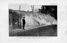
CUT ON FLAT SHOALS ROAD NEAR SCHOOL HOUSE, LOT 110, 15th DJST., DeKALB COUNTY, GEORGIA, SHOWING PEGMATITE DIKE IN MICA SCHIS'.r.
GEOLOGICAL SURVEY OF GEORGIA
S. W. McCALLIE, State Geologist
BULLETIN No. 30
A PRELIMINARY REPORT
ON THE
FELDSPAR AND MICA DEPOSITS
OF
GEORGIA
BY !3. L. GALPIN, Ph. D.,
Assistant State Geologist
ATLANTA, GA. CHARLES P. BYRD, STATE PRINTER
1915
THE ADVISORY BOARD
OF THE
Geological Survey of Georgia
IN THE YEAR 1915
(Ex-Officio) HIS ExCELLENCY, JOHN M. SLATON ......... Governor of Georgia
PRESIDENT OF 'I'HE BOARD
HoN. PHILIP COOK .......................... Secretary of State HoN. W. J. SPEER .............................. State Treasurer HoN. W. A. WRIGHT ....................... Comptroller-Gene:al HoN. WARREN GRICE ........................ Attorney-General HoN. J. D. PRICE ................... Commissioner of Agriculture HoN. M. L. BRITTAIN . . . . . . . . . . . . . Commissioner of Public Schools
LETTER OF TRANSMITTAL
GEOLOGICAL SuRVEY OF GEORGIA, ATLANTA, April 25, 1915.
To His Excellency, JoHN M. SLATON, Governor and President of the Advisory Board of the Geological Survey of Georgia.
SIR: I have the honor to transmit herewith the report of Dr. S. L. Galpin, Assistant State Geologist, on the Feldspar and Mica Deposits of Georgia, to be published as Bulletin No. 30 of this Survey.
Very respectfully yours, S. W. McCALLIE, State Geologist.
PREFACE
The preparation of this report was authorized for the purpose of
obtaining and supplying to the public, information regarding the
occurrence and nature of the feldspar and mica deposits which exist
in the State. That such information is in great demand is shown by
the frequent inquiries concerning these minerals addressed to the
Geological Survey.
The report contains, in addition to descriptions of feldspar and
mica deposits, one chapter dealing with the general geology of the
.area in which these deposits occur, and a second detailing the nature
of the rock pegmatite and the uses, values, and the like, of its most
important minerals, particularly feldspar and mica.
The collecting of this material was begun in May, 1912,. and con-
tinued until January, 1914. Much of the information was obtained
.at first hand either in the field or from laboratory study. The re-
mainder has been collected from various sources which are indicated
in the text by foot notes whenever possible to do so.
Progress on the report was halted in January, 1914, by the writer's
"Withdrawal from the active staff of the Survey. However, arrange-
ments were later perfected whereby he has been allowed to complete
the work. He takes this opportunity to acknowledge the Survey's
cordial co-operation, which has been a very material aid in the re-
-port's preparation.
:Department of Mining and Geology,
Iowa State College, Ames, Iowa.
s. L. GALPIN.
..
TABLE OF CONTENTS
ADVISORY BoARD LETTER OF TRANSMITTAL ................... PREFACE ................... TABLE OF CONTENTS ............................................. LIS'J' OF ILLUSTRATIONS
PAGE
iii iv v
vii-~~~
xii
PART I
PAGE
CHAPTER I. CRYSTALLINE AREA ..................................... . Geology ........................................................ . Location ....................................................... . Physiography ................................................... . Piedmont Plateau ............................................. . Appalachian Mountains ........................................ . Weathering .................................................... . Structure ....................................................... . Geologic formations ............................................. . Petrographic groups .......................................... . Archean System .............................................. . Carolina gneiss ............................................. . Roan gneiss ................................................ . Cambrian sediments ........................................... . Early igneous rocks ........................................... . Early granites .............................................. . Gabbros, peridotites, etc ...................................... . Effusive rocks .............................................. . Later igneous rocks ........................................... . Later granites .............................................. . Injection gneisses and foliate granites .......................... .
CHAPTER II. PEGMATITE ..........................................
Occurrence, composition, structure, etc ............................. . Origin of ....................................... ............... . Useful minerals of .............................................. .
Feldspar group ............................................... . Uses ...................................................... . Grading ................................................... . Impurities ................................................. . Testing .................................................... . Sampling .................................................. . Quarrying .................................................. . 'l'reatment .......................................... .
121 1
12 25 23 4-5 57 7-9 9-21 9-11 11-21 11-12 12-14 14-16 16-18 17-18 18 18 18-21 18-20 20-21 22-50 22-25 25-27 27-50 27-39 30-31 31-32 32-34 34-35 35 35-36 36-37
vii
Markets .......................................... ... Production ................................................. . Value ...................................................... . Quartz ....................................................... . 1\iica ................................................ ........ . Uses ....................................................... . Grading .................................................... . Production ................................................. . Prices ............................ ............... . Mining ..................................................... . Treatment ................................................. .
PAGE
37 37-38 3839 3940 4050 44-45 45-46 4647
47 47-48 48-50
PART II
FELDSPAR AND MICA IN THE GEORGIA PEGMATI'rES ............
51
Introduction .................................................... . 5152
Section I, Baldwin, Hancock, McDuffie, Warren, Richmond and Columbia
counties .................................................. . 5260
Topography .................................................. . 52
General geology .............................................. . 52-60
Carolina gneiss ............................................. . 53-54
Roan gneiss ................................................ . 54-55
Granites .................................................... . 55-58
Pegmatites ................................................. . 58-60
Baldwin County .......................................... . 5860
Warren County ........................................... . 60
Columbia County .......................................... . 60
Other counties ............................................ . 60
Section II, Lincoln, Wilkes, Taliaferro, Greene, Putnam, Jasper anl
.Tones counties ............................................ . 6171
Topography and geology ....................................... . 6171
Carolina gneiss ............................................. . 11162
Roan gneiss ................................................ . 62-\13
Granites ...... : ............................................ . 63-64
Injection gneiss ............................................. . 64
Pegmatites ................................................. . 64-71
Lincoln and Taliaferro counties ............................. . 65
Wilkes County ............................................ . 65
Greene County ............................................ . 65-67
Putnam County ........................................... . 67-68
Jasper County ............................................ . 68
Jones County ............................................. . 68-71
Section III, Butts, Monroe, Bibb, Crawford, Pike, Taylor, Harris,
and Muscogee counties ..................................... . 71-87
Topography and geology ....................................... . 71-87
Carolina gneiss ............................................ 72-73
Roan gneiss ................................................ . 73-74
viii
PAGE
The Pine Mountain formation ................................ . 74-lli
Granites
IG-77
niorite ..................................................... .
77
Injection gneiss ............................................ . 77-78
Pcgmatites ................................................. . 18-87
Butts County ............................................. .
78
Monroe County ........................................... . 798~
l\lica ................... . Bibb County ................................ .
818~
Cnnvfonl County ................................ .
8~-SG
.l\lica ..................................... .
S4
Taylor County ..................................... . rpson County ................................... .
S.J
s.:; Sli
:\lica ................ .
s:J.:-,li
Pike County
~(i
Talbot County ............... .
~ti-S/
~Iica ........................... .
Si
Harris County ..................................... .
,~/
l\lica .............................................. .
::""li
:\luscogee County . . . . . . . . . . . . . . . . . . . . . . . . . . . . . . . . . . . . . . . .
Sl
Section lV, Troup, Heard, i\lcri\Yethcr, CO\Yeta, Campbell, Fayette,
Spalding, Clayton and Henry counties. . . . . . . . . . . . . . . . . . .
SS-1 0 I
Topography . . . . . . . . . . . . . . . . . . . . . . . . . . . . . . . . . . . . . . . . . . . .
''S
Geology . . . . . . . . . . . . . . . . . . . . . . . . . .
. . . . . . . . . . . . . . . .
SSl 01
Carolina gneiss ................................... .
SD-HCI
Roan gneiss ..................................... .
DO
Early granites . . . . . . . . . . . . . . . . . . . . .
. ........ .
H0-91
Later granites . . . . . . . . . . . . . . . . . . . . . . . . ........... .
!11-\l:Z
Injection gneiss ................................ .
D~
Pegmatites ................................. .
H:! 101
Troup County . . . . . . . . . . . . . . . . . . . . . . . . . . . . . . . . . . . . . .
\l:?-9fi
Mica . . . . . . . . . . . . . . . . . . . . . . . . . . . . . . . . . . . . . . . . . . . . .
Dfi
l\ferhvcthcr County . . . . . . . . . . . . . . . . . . . . . . . . . . . . . . .
9697
Heard County . . . . . . . . . . . . . . . . . . . . . . . . . . . . . . . . . . .
97
Coweta County . . . . . . . . . . . . . . . . . . . . . . . . . . . . . . . . . . . . . . . . . . . . . 91-08
Campbell County . . . . . . . . . . . . . . . . . . . . . . . . . . . . . . . . . . . . . . . . . . . 98
I<'ayette County . . . . . . . . . . . . . . . . . . . . . . . . . . . . . . . . . . . . . . . . . . . .
98
Clayton County . . . . . . . . . . . . . . . . . . . . . . . . . . . . . . . . . . . . . . . . . . . . 99
Spalding County ........................................... 99-100
Henry County ............................................. 100-101
Section V, Rockdale, Newton, l\lorgan, walton, Oconee, Clarke, l\Iadison,
Oglethorpe, Elbert and Hart counties ......................... 102-llG
Topography . . . . . . . . . . . . . . . . . . . . . . . . . . . . . . . . . . . . . . . . . . . . . . . . . . . 102
Geology ....................................................... 102-llG
Carolina gneiss .............................................. 102-103
Roan gneiss ................................................. J 03-104
Granite ..................................................... 104-105
ix
P.\UE
Injection gneiss .............................................. 105-106 Pegmatites .................................................. 106-116
Rockdale County . . . . . . . . . . . . . . . . . . . . . . . . . . . . . . . . . . . . . . . . . . . 106 Newton County . . . . . . . . . . . . . . . . . . . . . . . . . . . . . . . . . . . . . . . . . . . . 107 Morgan County . . . . . . . . . . . . . . . . . . . . . . . . . . . . . . . . . . . . . . . . . . . . 107 Walton County ...................................... ,...... 107-108 Oconee County . . . . . . . . . . . . . . . . . . . . . . . . . . . . . . . . . . . . . . . . . . . . . 108 Oglethorpe County . . . . . . . . . . . . . . . . . . . . . . . . . . . . . . . . . . . . . . . . . 109 Clarke County . . . . . . . . . . . . . . . . . . . . . . . . . . . . . . . . . . . . . . . . . . . . . 109 Madison County ........................................... 110-111 Elbert County ............................................. 111-114
Mica ................................................... 113-114 Hart County ............................................... 114-116
Mica ................................................... 114-116 Section VI, Franklin, Stephens, Habersham, Banks, Hall, Jackson, Gwin-
nett, DeKalb and Fulton counties ............................ 117-129 Topography . . . . . . . . . . . . . . . . . . . . . . . . . . . . . . . . . . . . . . . . . . . . . . . . . . . 117 Geology ....................................................... 117-129
Carolina gneiss . . . . . . . . . . . . . . . . . . . . . . . . . . . . . . . . . . . . . . . . . . . . . . . 118 Roan gneiss ................................................. 118-119 Quartzites ................................................... 119-121
Tallulah Falls quartzite . . . . . . . . . . . . . . . . . . . . . . . . . . . . . . . . . . . . . 119 Toccoa quartzite ........................................... 120-121 Cambrian schists . . . . . . . . . . . . . . . . . . . . . . . . . . . . . . . . . . . . . . . . . . . . . 121 Granites .................................................... 121123 Injection gneiss ............ , . . . . . . . . . . . . . . . . . . . . . . . . . . . . . . ... . 123 Pegmatites ................................................. 123129 Pranklin County . . . . . . . . . . . . . . . . . . . . . . . . . . . . . . . . . . . . . . . . . . . 124 Stephens County . . . . . . . . . . . . . . . . . . . . . . . . . . . . . . . . . . . . . . . . . . . 124 Habersham County ......................................... 124125 Banks County ........... :. . . . . . . . . . . . . . . . . . . . . . . . . . . . . . . . . 125 Hall County ............................................... 125-128
M'ica ................................................... 125-128 ,Jackson County ............................................ 128129 Gwinnett, DeKalb and Pulton counties . . . . . . . . . . . . . . . . . . . . . . 129 Section VII, Forsyth, Milton, Cobb, Bartow, Paulding, Douglas, Haralson and Carroll counties ........................................ 129-140 Topography ................................................ : .. 129-130 Geology ....................................................... 130-140 Carolina gneiss .............................................. 130-131 Roan gneiss ................................................. 131-132 Granites ..................................................... 132-133 Diorite . . . . . . . . . . . . . . . . . . . . . . . . . . . . . . . . . . . . . . . . . . . . . . . . . . . . . 133 In.i eetion gneiss . . . . . . . . . . . . . . . . . . . . . . . . . . . . . . . . . . . . . . . . . . . . . . 133 Pegmatites .................................................. 133-140 Porsyth County . . . . . . . . . . . . . . . . . . . . . . . . . . . . . . . . . . . . . . . . . . . . 134 Milton County . . . . . . . . . . . . . . . . . . . . . . . . . . . . . . . . . . . . . . . . . . . . . 134
X
p_,(;E
Cobb County
........................................... 1:041:).)
Bartow County . . . . . . . . . . . . . . . . . . . . . . . . . . . . . . . . . . . . . . . . . . . . I;;.)
Paulding Count~ .......................................... 13.)13~
.:\li<.:a .................................................. . 131-13:"'\
nougl:.ts County . . . . . . . . . . . . . . . . . . . . . . . . . . . . . . . . . . . . . . . . . . . . J:3S
Haralson County ........................................... 138139
( 'arroll ( '<nlllty ............................................. 139140
Sc'<.tion YJII, Cherokee, Pickcns. Uilmer, Fannin, Ilot\\'"ln, Lumpkiu, ('uion, \\11ite, To11ns all<l Hahun connties ..................... 1411/cl
Topography . . . . . . . . . . . . . . . . . . . . . . . . . . . . . . . . . . . . . . . . . . . . . . . . . . . 141 Geolog~ ....................................................... 141113
Carolina gneiss . . . . . . . . . . . . . . . . . . . . . . . . . . . . . . . . . . . . . . . . . . . . . . 14~ Hoan gneiss ................................................. 14~14:1 Qnartzite . . . . . . . . . . . . . . . . . . . . . . . . . . . . . . . . . . . . . . . . . . . . . . . . . . . 143 Gr:lllite ..................................................... 1-:3144 Basic intrnsions . . . . . . . . . . . . . . . . . . . . . . . . . . . . . . . . . . . . . . . . . . . . . . .1-1+
lnjcdion gneisses . . . . . . . . . . . . . . . . . . . . . . . . . . . . . . . . . . . . . . . . . . . . 144 l'tgmatites .................................................. 1441/:l
('hnokce Connty ........................................... 1451.)11
Pickcns County ............................................. l.:J0-1.).)
(1ilmcr mt<l Fannin eountics ................................. J.);).J.:Jii
1)a \\son ( 'onnt ; . . . . . . . . . . . . . . . . . . . . . . . . . . . . . . . . . . . . . . .
1.)(i
Lmnpkin "'"' \'nion ,.,,uutics . . . . . . . . .
. .............. 1.)().16.)
\\'hite ( 'ount.' . . . . . . . . . . . . .
.. .. .. .. .. .. .. .. ..
. .. 1().ili).S
Towns ( 'ounty .. . .. . .. .. .. .
.. .. . .. . .. .. .. .. .
Hi~
Rabun ( 'onut~ . . . . . . . . . . . . . . . . . . . . . . . . . . . . . . . . . . . . . . . . . . . . . lGS-11:0
Summary ...................
. .......................... 1/:1-114
Jo'Pl<lspar . . . . . . . . . . . . . . . . . . . . . . .
. .......................... 113-1/4
:\liea . . . . . . . . . . . . . . . . . . . . . . . . . . . . . . . . . . . . . . . . . . . . . . . . . . . . . . . . . 114
APPE:O.:DIX J, A lts!ra..ts of patents issnec1 h~ thP T'nite<l ~:-\tatrs Pnttut ()fl'ice
on methncls for extrading pot,sh an<l other :mlJslnll('l'S from silieatc
nH'ks and minnals, CS]Wtiallv felclspar ........................ 1/.)-170
APPE:O:DJX IT, nronn<l felclspar '" :1 c<minHnial frrtilizer ................ 1191 S3
APPE:O.:lllx Tl I, ('!Jprt lepus its of <:eorgia . . . . . . . . . . . . . . . . . . . . . . . . . . . . . . . lSil-1 S4
l;,iDEX . . . . . . . . . . . . . . . . . . . . . . . . . . . . . . . . . . . . . . . . . . . . . . . . . . . . . . . . . . . .
] .~.)
Xl
LIST OF ILLUSTRATIONS
Cut on Flat Shoals Road near school house, Lot 110, 15th Dist., DeKalb County, Ga., showing pegmatite dike in mica schist
Frontispiece
PLATES
FACING PAGE
I. A. Flat rock exposures 3 miles southeast of Sparta, Hancock
County, Ga. . . . . . . . . . . . . . . . . . . . . . . . . . . . . . . . . . . . . . . . . . . . . . 32
B. Boulder outcrop, 1 mile northwest of Clinton, Jones County, Ga. 32
II. A. Decomposed ,roadside outcrop of injected and pegmatized Caro-
lina gneiss, Baldwin County, Ga. . . . . . . . . . . . . . . . . . . . . . . . . . . . 48
B. Foliate or injection gneiss exposed in quarry near Athens,
Cla;rke County, Ga. . . . . . . . . . . . . . . . . . . . . . . . . . . . . . . . . . . . . . . . 48
III. A. Irregular pegmatite dike cutting biotite gneiss (Carolina),
roadside exposure, Baldwin County, Ga.. . . . . . . . . . . . . . . . . . . . 64
B. Kaolinized pegmatite lenses in decomposed mica gneiss (Caro-
lina), Rabun County, Ga.................................. 64
IV. A. NaTrow pegmatite tailing out into granite, quarry near Sparta,
Hancock County, Ga...................................... 80
B. Horizontal pegmatite cut and slightly displaced by trap dike,
Lakewood, Fulton County, Ga................... . . . . . . . . . 80
V. A. Pegmatite showing irregular texture and characteristic rough
surface of outcrop . . . . . . . . . . . . . . . . . . . . . . . . . . . . . . . . . . . . . . . 9,6
B. A series of illustrations s'howing the textural relations of g;ranite
and pegmatite . . . . . . . . . . . . . . . . . . . . . . . . . . . . . . . . . . . . . . . . . . . 96
VI. A. Negative printed direct from a sheet of stained and "Specked"
mica (from Troup Co.) .................................... 112
B. Heap of muscovite books, '.Villiams Mica Mine, Lumpkin
County, Ga. . ............................................ 112
VII. A. & B. Hornblende schists injected and deformed by granite, 31f2
miles south of Dennis, Putnam County, Ga.................. 128
VIII. A. Decomposed mediuin- and fine-textUTed pegmatlite dike, road-
side outcrop near Jefferson, Jackson County, Ga ............ 144
B. Open cut of Dean Mica Mine, near Woodstock, Cherokee
C'ounty, Ga....................... " ..................... 144
IX. A. Inclusion of diorite gneiss in granite, quarry near Normal School,
Athens, Clarke County, Ga ................................ 160
B. Entrance to Williams Mica Mine, Lumpkin County, Ga ........ 160
FIGURES
Fig. 1. Plan of the workings at the mica mine neaT Gainesville, Ga. . . . . . . . 127 Fig. 2. Plan of the Cook Mica Mine, Cherokee County, Ga . . . . . . . . . . . . . . . . 149 Fig. 3. Sketch map of parts of Lumpkin aRd Union counties showing mica
mine and pTospect locations . . . . . . . . . . . . . . . . . . . . . . . . . . . . . . . . . 158
MAPS Ma'p showing the principal pegmatite bearing areas and some geologic for-
mations of the State . . . . . . . . . . . . . . . . . . . . . . . . . . . . . . . . . . . . . . . . . . . . . . 16
xii
FELDSPAR AND MICA DEPOSITS OF GEORGIA
PART I.
CHAPTER I.
CRYSTALLINE AREA
GBOLOGY Because of characteristic uifferenees of texture, structure and origin, the rock formations of Georgia are grouped in three divisions, which extend beyond the borders of the State both to the northeast and southwest, forming long inlgnlar hands lying roughly parallel to the Atlantic coast. 'l'hese geologie divisions, named in the order of their antiquity, are known as the Crystalline belt, the Paleozoics. and the Coastal Plain sediments. This report is particularly concerned with the first named division, since practically all of the valuable feldspar and mica deposits oecur within the Crystalline belt. The following brief discussion of the geologic relations and features of this group of rocks is intended to aid the reader's understanding, both of geologic terms and of conditions which may be favorable or unfavorable to the discvvery and exploitation of pegmatitic deposits containing feldspar, mica, <lmtrtz or other rarer minerals which are sometimes marketable.
LOCATION: 'l'he Crystalline helt comprises a group of holocrystalline metamorphic and igneous rocks '' ... which extends continuously from Alabama to Maryland, and, 'vith only a slight break, into Pennsylvania and finally into New Jersey as far as Trenton."1 Although
1 Pre-Cambrian Geology of North America: Bull. e. S. Geol. Survey, No. 360,
1909, p. 706.
GEOLOGICAL SURVEY OF GEORGIA
disconnected, the series continues to the north and east into Canada. In the southeastern States, where they cover a large territory, these rocks lie between folded and faulted, but little metamorphosed Paleozoic sediments on the northwest, and slightly consolidated Cretaceous sediments to the south and east. The line of separation from the formations on the northwest follows a great thrust fault, known in Georgia as the Cartersville Fault. King1 describes its location as ''a line drawn south from a point a few miles east of Cohutta Springs, Murray County, to Cartersville, Bartow County, and then south of west to Esom Hill, Polk County.'' The greater resistance to weathering and erosion of the crystalline rocks has resulted, at many points, in a rather marked escarpment east and southeast of this fault.
The outcrop of the crystalline rocks toward the southeast is limited by the covering of Coastal Plain sediments which, in this State, extend from the Atlantic Ocean and Florida to a line drawn
from Columbus to Augusta through Macon and Milledgeville. This
line of division is commonly called the "Fall Line" because of the cascades and water falls which are found in most streams where they pass from the crystalline onto the easily eroded sedimentary rocks.
From the foregoing it is seen that the greater part of North Georgia, comprising an area of about 12,430 square miles, is underlain hy crystalline rocks. 2
PHYSIOGRAPHY
THE PIEDMONT PLATEAU
The Piedmont Plateau and the Appalachian Mountains are the main physiographic features of the Crystalline area. The former is of considerably greater extent than the latter, and is a broad upland, rising gradually from the Coastal Plain to the flanks of the Blue Ridgr, which forms the divide between the headwaters of streams draining into the Miss1ssippi basin, and of those which reach the Atlantic
'King, Francis P., Corundum Deposits of Georgia: Bull. Geol. Survey of Ga. No. 2, 1894, p. 60.
'King, loc cit.
.
CRYSTALLINE AREA
a
Ocean and the Gulf of Mexico by a more direct southward or southeastward route. The latter streams, having a shorter and therefore steeper course to tidewater, have effected more rapid erosion, producing a lower plain than exists to the northwest of the mountains.
In its general features the Piedmont Plateau is a peneplain, on which there are comparatively few "monadnocks" remaining. Since its development the whole region has been lifted several hundred feet relative to sea level. The major streams have already re-cut their channels nearly to the new grade, developing rather broad, but steep sided, valleys which are floored by flood plains except where resistant rocks have caused "narrows." The tributary drainage is less mature. Sections which lie along or near the headwaters of the trunk streams are usually characterized by a sharp "ridge and valley" topography.
The following table, showing the rate of fall for the main streams of the Piedmont as they near its southeastern border, was compiled from data published in Bulletin No. 16 of this Survey:
Rate of Fall of Principal Streams along the Fall Line in Georgia
River
HPight above tide at
Distance measured up stream
!
Rate of Total 1 rise, ft. rise iper mile
Where empty
feet i Savannah ______ Augusta ____ 98; Oconee ________ Milledgeville_215, Ocmulgee ______ Macon _____ 280 I Flint _________ Fall Line ____ 327
Chattahoochee __ Columbus ___ 190 I
miles 64 54 50 45 35
feet !
257 211 219
I( 4.0
3.9
Atlantic
4.4
Ocean
334
7.2
Gulf of
368 i' 10.5 [l Mexico
The streams draining directly into the Atlantic Ocean are seen to be nearer base-leveled than the other two which flow to the Gulf of Mexico. The most important inference to be drawn from this fact is that in the western section where erosion is now a little more rapid, due to the higher stream gradients, the residual mantle of rock decay will be thinner and exposures of fresh rock more frequent. It is not possible to verify this inference from our limited observations, although what evidence we have seems to be favorable to it.
4
GEOLOGICAL SURVEY OF GEORGIA
THE APPALACHIAN MOUNTAINS
This physiographic province, which has its greatest development in North Carolina, extends some distance into the northern part of Georgia, covering parts or all of Rabun, Towns, Habersham, White, Lumpkin, Union, Fannin, Gilmer, Pickens and Murray counties. The southeast front of the mountains is rather regular in trend, and -of steep slope. On the southwest the lines of drainage have extended into the mountain area in channels more or less parallel to the strike -of the rock formations, producing a frayed or toothed boundary between the mountain and plain provinces. On the west the termination of the Appalachian Mountain province is again sharp where the scarp east of the Cartersville Fault marks its farthest westward extension.
The present mountains are the result of dissection of an ancient peneplain which is thought to have been heave~ up as a result of crustal readjustments which began about the close of the Carboniferous period. That the elevation of the plateau was discontinuous is shown by the existence of several incompleted peneplains, of which the Piedmont is latest and most conspicuous. Erosion has destroyed most of the original plain, traces of which may exist on the higher ridges. From the elevations of these traces, a reconstruction of the ancient plateau is possible, and indicates that there was an upward slope from Georgia into North Carolina. The altitude of the plateau varied from 5,000 feet in the extreme north of Georgia to as little as 2,500 feet farther south in the present mountain province.
The mountains of the Crystalline area are.less uniform than those -of the Paleozoic area to the northwest, as there is less regularity in the succession of the formations and also less difference in the rate -of erosion of the various rock types. Some of the streams of the region, especially those which flow northwest, west or southwest, have developed, at least locally, considerable flood plains in their valleys, but the others still flow in deep, narrow gorges until they reach the Piedmont Plateau, where after a few miles the valleys usually
.3
hroaden out 111 more mature form. The topography of the tcrritol'.): draitH'tl b.' these s1riftn stnams is naturally more rugged than that ,dwre the larger streams are more nearly mature.
Petrogt;lphieally and struetnrally the Appalachian Mountains and the Piedmont Plateau regions mp similar, hut, 0\Ying to the 1narketl differences in their topogTaphies, the amount and nature of resitlual or tleeaye<l l'Oek is much greater in tlw Pie<lmont, n fact which is of tonsi<lera hie importance in emu1eetion 1ritlt the prospecting and dt,t'lopnwnt of min era I <leposits.
W EA'l'IIERING
~\!I ro<ks, \\'hL'll <'xposed <1t the earth 'H surface, an~ suhj!'ct, more or less. to tleeay. 'rhe processes of disintegration and decomposition by 1rhich this decay is brought about are knmrn as "weathering"; and its products. if they remain where tlH'Y were formed, are designated hy 1he qualifying adjPdive "nsidual. ' Residua1 materials, removed by erosion from their point of otigin, may form colluvial, alluvial, or sedimentary <leposits, derwnding upon the manner in which they are transported and lai<l down. 'l'hns, the deposits formed at or near the hase of a hilL clue to slumping m rolling, arc colluvial, the matrrials \Yhich make up the flood plains along streams are alluvial, aml those \Yhich eolleet along the shores of quid bodies of \Vater are sedimentary.
'l'he rate of 1reatlwring in any rock formation depends upon the structure an<l texture of the rock, its chemical and mineralogical composition and the nature of the weathering agencies. As water, carrying small percentages of mineral and organic compounds in solution, is the greatest factor in producing decay, weathering is more rapid \Yhere joints and other fractures offer free access to moisture. Of the common minerals the more basic are usually among the first to he altered by weathering. It follows that the basic rocks will usually decompose more rapidly than those of more acid character, but exceptions seem to occur where conditions favor the formation through decomposition of some mineral or minerals which protect
6
GEOLOGICAL SURVEY OJ!' GEORGIA
the rock from the weathering agencies. Highly feldspathic rocks are generally most rapidly weathered at or near the upper surface of the underground water, while hornblende schists, diorite and other ferromagnesian rocks weather more rapidly nearer the surface. The products of decomposition which remain as residual material are mainly clay, quartz, and some iron compounds, principally limonite. Fragments of mica and other slowly weathered materials are also present in varying amounts. The reddish and brownish clays of the Piedmont are practically all of residual nature. Often they have been bleached by the leaching action of underground waters, giving a gray or bluish white clay. Such instances are frequent where springs issue through the residual material and are most common near the bottom of rather deep valleys or gullies. Along the southeastern border of the crystallines, there is frequently a sort of hardpan at, or close to the surface, formed apparently by the cementing action of recrystallized materials which were leached from the underlying rocks. Such hardpan is usually found above hornblendic rocks, but the exact nature of the deposit has not been determined.
Topography exerts considerable influence upon the rate of weathering and upon the accumulation of weathered materials. When slopes are steep, the run-off of rain water is rapid, and less moisture finds its way down into the rocks than in the fiat areas, resulting in less decomposition. On the other hand, where slopes are gentle and the run-off retarded, a greater percentage of rainfall seeps into the rocks, aiding decomposition, and leaving less water to drain from the surface, so lessening the amount of erosion. The latter conditions are found in the Piedmont Plateau. Weathering there may reach a depth of one hundred feet and residual material covers most of the s~rface. The natural fresh rock exposures are for the most part ''ledges'' of more resistant formations. These outcrops are to be found most frequently in stream beds, but also occur on valley sides and occasionally upon the surface of the old peneplain. In general, the mantle of residual clay and soil is deeper on the uplands which have not yet been dissected by stream erosion.
.
CRYSTALLINE AHEA
In the mountains, erosion has kept pace with weathering, and there are fewer 'areas where fresh rock can not be found at or near the surface. This fact has lead to the popular conception that there are more mineral deposits in the mountain region, but such is not necessarily the case, although they are more in evidence there. The depth of weathering has a strong bearing upon the commercial availability of either mica or feldspar deposits.
STRUCTURE
Probably the most striking structural feature of the Crystalline area is the uniform northeast-southwest strike of its formations and the southeastward dip of the schistosity or foliation of the rocks. Locally, other directions of strike and dip may be notetl, and in one or two instances, as in the region between Ellijay and Dahlonega, a change in strike to the northwest is noticeable over a large area. Small faults, folds and intense crumpling of the foliated rocks may be observed in most parts of the metamorphic belt. Occasionally larger faults are well defined, as along the northwestern border. These faults are overthrusts in which formations from the southeast have been forced upon those lying northwest of the fault plane.
The ridges of Pine and Oak mountains, in the southwestern section of the Crystalline area have resulted from differential erosion on the limbs of an anticline in which a massive quartzite is the most resistant member. In the northeastern part of the State a large syncline is suggested by the quartzite which dips southeast from Tallulah Falls and northwest from the vicinity of Toccoa. Evidence suggesting the existence of further extensive folds has been noted in Troup County, and at other localities, mainly to the northwest of the Chattahoochee River. Considerable bowing or arching of the rocks has taken place also in the vicinity of the larger intrusive masses, especially on the southeastern side of such bodies.
It is possible that there are great faults in the eastern and
8
GEOLOGICAL SL'RVEY OF Glo'ORGUt
central portions of the belt as well as on the northwestern border, but their demonstration must wait upon a careful and thorough examination of the territory. The presence of complicated folding throughout the area is presumed because of the smaller plications, and the occasional larger anticlines and synclines, which can be detected by means of some well nuukecl formation. The widespread uniformity of dip (to the southeast) is uplained by the assumption that excessive pressure acting from the southeast toward the northwest compressed all but the most resistant formations into closed folds which were overturned to the nortlnYest by the continued forces. If these folds were not also broken hy faulting it must have been due to their burial below the zone of fracture at the time of greatest dynamic activity.
Many of the Crystalline rocks show more than a single direction of schistosity or foliation, indicating that they have been subjected to at least two periods of compressive metamorphism. It is highly probable that some of the rocks have passed through more than two of these periods, but the signs of earlier ones have been obliterated by the later. In as much as the compressions which caused the metamorphism of the non-crystalline rocks were doubtless accompanied, above the affected zone, by marked uplifts of the earth's surface, the time of their occurrence has been linked with the great elevations which, in the southeastern States. brought to a close the Ordovician and Carboniferous eras.1 The physiographic record indicates that there have been several lesser uplifts since that which brought to a close the deposition of Carboniferous sediments, but it is not known that any metamorphic structures were developed with them in the rocks now exposed at the surface. Probably the small faults which are prevalent throughout the Crystallines are generally related to one or more of these later uplifts.
A correlation of this kind is of considerable service in unravelling the tangled record of the Crystalline area, although its application
1 La Farge, Lawrence, and Phalen, \V. C., Ellijay folio (No. 187), Geol. Atlas U. S., U. S. Geol. Survey, 1913.
.
CRYSTALLINE AREA
is often beset with difficulties. It is probably of greater importance, in connection with this report, to bear in mind that there have been two, or possibly more, periods of great compression which have effected the older Crystalline formations, and that, in general, only such rocks as have formed since the latest metamorphism are wholly free from signs and effects of great pressure upon them.
GEOLOGIC FORl\IATIONS
The geologic formations of the Crystalline area comprise rocks of igneous, sedimentary, and metamorphic origin. All except the later igneous intrusives, have been considerably metamorphosed, usually to such a degree as to partly or wholly obscure their primeval characters. In many cases classification as to origin is impossible from our present knmvledge. It is also a difficult mattei to determine the age of a particular rock type or formation more than relatively, and in many cases even such determination is open to doubt.
The age relations of the Crystalline rocks may be determined, m part, by the amount of metamorphism they show, and, in part, by their contacts with other formations. Fossils have been reported from one or two localities of the metamorphic belt, but they are absent or have been obliterated from the bulk of the Crystallines.1 The rocks of the Crystalline area may he divided into eight petrographic groups, as follows:
PETROGRAPHIC GROUPS
Group I. Here are placed all formations m which metamorphism has been so complete that it is impossible to determine whether they were of igneous or sedimentary origin. While the bulk of thes6 rocks are probably Archean, or at least pre-Cambrian in age, there are some which may belong to the Cambrian and Ordovician periods.
1 Hopkins, Oliver B., Asbestos, Talc and Soapstone Deposits of Georgia: Bull. Ga. Geol. Survey, No. 29, 1914.
10
GEOLOGICAL SURVEY OF GEORGIA
The earlier rocks of the group are described by Keith1 under the name Carolina gneiss.
Group II. In the second group are classed the formations which, because of composition, field relations, or other characteristics, seem to have been sediments originally. In many cases a formation may be placed either in Group I or II. The rocks in the second group have a range of age similar to those in the first, although it seems probable that a larger proportion of the second group is Paleozoic. Those of Archean age would also be classed with the Carolina gneiss, mentioned above, and more fully detailed in a later paragraph.
Group III. The third group is made up of metamorphic basic rocks which are of igneous origin, and comprises, in the main, a series {)f hornblende schists which Keith2 has named the Roan gneiss.
Group IV. Distinctly metamorphosed granitic rocks are classed here. The dividing line between this and groups V and VI is often difficultly drawn.
Group V. This group consists of rocks which have been formed by the injection of granitic or pegmatitic material along the planes of foliation or shearing in older rocks. Most of these gneisses seem to have been formed at the time of the later granite intrusions and are designated as injection gneisses.
Group VI. In the sixth group are placed the granitic rocks which show few or no signs of metamorphism. It seems probable that in age they are as recent as the latest period of intense metamorphism. If so, they are probably to be classed as late Carboniferous, or younger.
Group VII. Group seven is made up of pegmatitic rocks ranging in age from pre-Cambrian to post-Carboniferous. A detailed geologic discussion of the pegmatites follows in Chapter II.
Group VIII. The last group is composed of diabase and ti'ap dikes, and has scattered representatives throughout the Crystalline
1 Keith, Arthur, Folios (Nos. 116, 143, 147, 187 and others), Geol. Atlas U. S., U. S. Geol. Survey.
2 Keith, Arthur, Roan Mountain folio (No. 151), Geol. Atlas U. S., U. S. Geol. Survey, 1907.
.
CRYSTALLINE AREA
11
area. These dikes are younger than all of the groups mentioned above, and, as they have no particular importance in this report, will receive little further mention.
Completed detailed study of the Crystalline geology of Georgia is limited to a single quadrangle in the northwestern corner of the area.1 Several quadrangles in North Carolina have been mapped by the U. S. Geological Survey and are, in their more general geologic features, similar to much of the Crystalline area of Georgia. In the brief description of the areal geology of this division use will be made of as many of the formation names adopted by the United States Geological Survey as seem applicable. The formations are arranged as nearly as possible in order of their antiquity.
ARCHEAN SYS'rEM
CAROLINA GNEISS
Carolina gneiss is the name used by Keith2 to designate the most ancient rock series of the Crystalline area. Its representatives occur in every county where the Crystallines are found. 3 In its most typical development it is made up of a series of schists, largely micaceous, garnetiferous, cyanitic or siliceous, and gneisses mainly biotitic, but carrying more or less muscovite. The outcrops of Carolina gneiss are broadly band-like, with a general northeast-southwest trend. As exposed in road cuts and along streams, the rocks are more or less weathered to red or yellow clay which appears to be banded because of layers of mica which have resisted decay more successfully than other minerals. These bands may be fairly straight for the distance exposed or they may be bent and crumpled. The original character of the formations comprising the Carolina gneiss is usually obscured by complete metamorphism. Both sedimentary and igneous rocks are doubtless represented. Associated with this gneiss are lentils and layers of a medium to fine grained granite, which are of later origin,
1 Ellijay folio (No. 187), Geol. Atlas U. S., U. S. Geol. Survey, 1913. Keith, Arthur, Joe. cit. a This excepts the semi-Crystalline area of the Ocoee region.
12
GEOLOGICAL SURVEY OF GEORGIA
but which are persistently present. In many localities the Carolina. schists appear to be changed to banded gneisses through injection of granitic material along the planes of foliation.
The schists and gneisses of the Carolina are differentiated from other schists and gneisses mainly by their age relations with later intrusive rocks, especially the hornblendic schists and gneisses of the Roan formation.
Although of widespread occurrence, fresh outcrops of Carolina. gneiss are not so frequent as might be expected, owing to the depth to which rocks of the formation are ordinarily weathered. Except locally, the topography of the country underlain by this formation is rather featureless. The residual clay soils produced by its decay vary in color from yellowish gray to red. Their fertility varies widely, but is low on the average, although the biotitic gneisses seem to weather to fair soils. The Carolina gneiss is of considerable importance as the country rock, for many, or in fact, for most of the pegmatite dikes which are, or may be, of commercial value. These dikes occur in great numbers and varying sizes, and may be found wherever the Carolina gneiss appears.
ROAN GNEISS
The Roan gneiss1 consists of varieties of basic schists and gneisses: of which the two most common types are hornblende schists and metadiorite. The fresh rock is of a dark color, frequently of greenish cast and of medium, or fine texture. The feldspathic varieties present more of a "salt and pepper" appearance. The rock is always more or less foliate or schistose and in some areas possesses something of a slaty cleavage. Occasionally, good exposures show well two series of metamorphic structures, in which the earlier seems usually to be the more complicated. Injections of granitic material have produced great changes in the hornblendic rocks, forming banded gneisses and possibly the "foliate" granites. In occurrence the Roan is almost as
1 Named by Keith because of extensive outcrops of the formation on Roan Mountain, N. C. Loc. cit.
.
CRYSTALLISE AREA
13
widespread as the Carolina gneiss, but siugle outcrops arc characteristically narrower and more ribbon like. These ribbons or bands may vJary from a few inches to several hundred feet in width, and they may be traced many miles along the strike. Zones of these hands .extend across this State, and have been reported by other geologists as contiuuing for hundreds of miles to the northeast. Frequently, narrow bands of Roan and Carolina alternate over considerable areas.
..While present to some extent throughout the Crystalline area, the hornblende schists are found to be considerably more prevalent in two zones. 'l'he southeast zone passes from ::Uuscogee County north 50-60 east through parts of Talbot, Upson, Crmdord. Bihb, ~Ion roe, Jones, Baldwin, Hancock, Taliaferro, "\Vilkes and I.Jincoln .counties. It has an average width of perhaps 3 miles, but offshoots and outliers may extend several miles from the main zo11e. 'l'hc northwestern belt or zone has its greatest developmcut in the north.ern parts of Paulding and Cobb counties, but (xtemls on across Cherokee, Dawson, I,umpkin, white, Union, IIahersham and Rabun counties. A third lesser zone enters the State iu 'l'roup County, but it has been so frequently displaced hy later intrusions that only traces remain. 'l'hese may be found iu Heard, Cmveta, 1\Ieriwether, Fayette, Clayton, Campbell, DeKalb, G1rinnett, Hall, Banks, I<'raukliu and Stephens counties.
Natural outcrops of the R.oan gneiss are usually somewhat weathered to a deep red or chocolate clay, which, when 1ret, becomes decidedly sticky. Occasionally conditions are such that a yellow or brown ocher is produced instead of the red clay. lt is frequently possible to follow an outcrop of the formation b,v the deep red residual soil which covers it, and the large number of fragments of secondary quartz found in this soil. Although weathering rather rapidly, as a whole, there are frequently resistant layers of the Roan 1vhich stand up above the surface as ledges and in the mountains form bold cliffs .and ridges.
Where well developed, the R.oan IS easily recognized, although
14
GEOLOGICAL SURVEY OF GEORGIA
weathered, but where intercalated with layers of Carolina gneiss or when altered by the injection of graniti~ material it is traced with difficulty.
In origin, the Roan gneiss is considered to be a metamorphosed basic intrusive, cutting the Carolina gneiss, and itself cut by many later igneous bodies. From conditions noted in some localities, it seems probable that there are hornblendic schists which have been derived from basic surface flows or sills and also a few instances where apparently the metamorphism of sedimentary rocks has produced hornblendic schists very similar to those of the Roan gneiss. In this work no attempt has been made to classify these separately, although it seems probable that ultimately it will be desirable to do so.
Hopkins1 has examined several thin sections of the hornblendic rocks of the State and from his findings, together with chemical! analyses, he concludes that few of these rocks are truly diorites, but are, for the most part, more basic. He ascribes a common mode of origin for the basic series of rocks, including peridotites, pyroxenite& and other basic g-ranitoid rocks, considering that the group represents the products of a single period of eruption, possibly strung out over a conside1-able time interval.
Associated with the Roan gneiss are (1) the peridotites, etc., just-
mentioned, and (2) a series of grano-diorites ( n' aplites and;
pegmatites, which is usually characterized by a marked pinkish color. The latter associates of the Roan gneiss occur more frequently in the southeast zone, and in the western part of the northwest zone, a& defined above.
CAMBRIAN SEDIMENTS
The greater part of the known metamorphic Cambrian rocks liewithin the area classed as "semi-Crystalline" by King.2 This area is. bounded on the northwest by the Cartersville Fault and on the south-
1 Hopkins, Oliver B., Asbestos, Talc and Soapstone Deposits of Georgia: BulL Ga. Geol. Survey, No. 29, 1914.
2 King, Francis P., Corundum Deposits of Ge<>rgia:Bull. Ga. Geol. Surveyr No. 2, 1894.
.
CRYSTALLINE AREA
15
east and east by faults which follow closely the Louisville and Nashville Railroad from the North Carolina line as far south as Canton, whence the border holds a rather direct course southwestward, through Allatoona, north of 1\IcPherson, 3 to 4 miles southeast of Buchanan and beyond the State into Alabama near the northwest corner of Carroll County. The geology of the northern part of this belt has been described in detail by La Forge and Phalen.1 quartzite; graywacke; mica, chlorite, talc, ottrelite, graphite, garnet, cyanitc awl staurolite schists; marbles; and a few hornhleml.c-garnet gneisses arc' the main rock types of the area. Metamorphism is less pronouncecl. tmyard the west, but on the east it is often difilcult to distinguish the rocks of this series from those of the Carolina gneiss. 'l'his group of Cambrian rocks has been mapped and separated into the following formations in the aforementioned work:
N ottelcy quaTtzitc ::\furphy marble Yallcytown formati(}n Brasstown schists Tnsquitec quartzite Xantahala slate Great smoky formation
There are but few pegmatites known within the area where ilwse rocks occur, and it may he that those few are in Carolina gneiss which has been upfolcled with the later schists.
A narrow belt of schists with, at places, lentils and layers of limPstone, extends from Xorth Carolina, across the JJOrtln,est corner of South Carolina, into and beyond Strphem; Count~-. This helt has been mapped in Georgia as far southwest as l<'nlton County. when it passes 5 or 6 miles northwest of Atlanta. Keith has !lt>serihrd tlw northeastward continuation of this sl'ries in the Carolinas under tlw name of Brevard schists. 2 Parallel to thi:-; bdt an!i on ei1htr side of it there arc several belts of quartz R<'hists and qnartzit<'. The most
1 La Forge, Lawrence, and Phalen, \V. C.. Ellijay foliu L'\u. 1.'7), GeoL ,\!las U. S., 1J. S. Geol. Survey, 1913.
'Keith, Arthur, Pisgah folio (Ko. 147). GeoL Atlas 1". R., T'. R. i;<'<>L Rtll'\"PY.
1907.
16
GEOLOGICAL SURVEY OH GEORGIA
persistent of these strips continues to the southwest through Douglas, Carroll and Heard counties into Alabama. Others, less persistent, are to be found in Milton, Forsyth and Hall counties on the northwest, and in Stephens, Banks, Hall, Gwinnett and DeKalb counties on The southeast of the known Cambrian strip. It is not certain whether these quartzites should be classed as Cambrian or whether they are earlier. These quartzites are of some service as horizon markers in the area and will doubtless be useful in unravelling the detailed structure of the region. Schists, graywacke and other rocks of probable sedimentary origin, but of undeterminable age, occur at other points in the State. The more notable belts are (1) in southern Lincoln, and northern Columbia counties, extending southwest to eastern Baldwin County, disappearing there under the Coastal Plain sediments; (2) in central Hart County, extending southwest into Madison County and possibly farther; (3) in the vicinity of Pine Mountain, extending from Harris County east and north to Monroe County and possibly farther; (4) in northwest Heard and southern Carroll counties and extending northeast through Douglas, into Cobb County; (5) in Habersham, Rabun and White counties, extending southwest into Lumpkin, Dawson and Cherokee counties. In most of these areas, although Roan gneiss was found to some extent, the actual age relations of the schists to that formation were not deter~ mined. Some of these schists may be more ancient than the Roan gneiss, but in the main they are younger. As a rule, the rocks of definitely sedimentary origin contain fewer pegmatitic intrusions than do the Carolina or Roan gneisses.
EAR,LY IGNEOUS ROCKS
Although it is probable that the various igneous rocks which have been formed since the intrusion of the Roan gneiss represent several distinct periods of igneous activity, yet, from our present knowledge, it is not desirable to classify them in more than two groups. Any given igneous formation showing marked signs of metamorphism, such as complete foliation, or the thorough development of shear
r
l
.
CRYSTALLINE AREA
17
planes, is consigned to the group of early igneous rocks. Those formations which are mainly free from evidences of metamorphism are then classed as later igneous rocks. On this basis, the rocks of the first group may have been formed at any period following the intrusion of the Roan gneiss up to the close of the Carboniferous period. It seems probable, howevE-r, that most of the "early" igneous activity was confined to two intervals-the first in pre-Cambrian times and the second about the close of the Ordovician.
"EARLY" GRANITES
Gneissic granites, cutting the Carolina and Roan gneisses, are of _frequent occurrence. Hayes' has described a granitic gneiss which .occurs in the semi-Crystalline area in Bartow and Cherokee counti('s. He points out the presence of pebbles of this gneiss in the basal member of the overlying Cambrian rocks, proving clearly that the .granite from which this gneiss was formed was intruded and metamorphosed in pre-Cambrian times. Other rather large bodies of granitic gniess occur somewhat to the south and southwest in the vicinities of Acworth, Cobb County, and Dallas. Paulding County. respectively. Farther south in Cobb County therl' is a medium grained, sheared granite which extends f'onthwestward parallel to the Chattahoochee River into Carroll Count.Y. Anotlwr large hocly of granitic gneiss extends from Gwinndt alHl walton counties southWI'St .and northeast into adjoining counties. There are many other .smaller outcrops of these older granites throughout the ( :rystallitH area. One type of gneiss is interesting because of its cousta nt asso~ia. tion, wherever it is found. with rocks of the Roan gtwiss. It is a medium grained, pink to nearly white grano-diorite ( "?) gneiss. evidently considerably later than the Roan in origin. The rock is usually marked by its brownish weathered surface lined by minutP green vPiulets of epidote. The granitic gneis:;;es in general show sonw variety in composition, with a general tendency toward a rock high in biotite and frequently carrying considerable amounts of plagioelaS(' feldspar.
1 Hayes. C. '\Villard, Geological Relations of the Iron Ores in the ( 'arters\'ille District: Trans. Am. Inst. :\lin. Eng., Vol. 30, pp. 40u-S.
GEOLOGICAL SURVEY OF GEORGIA
S. W. McCALLIE, STATE GEOLOGIST
MAP
SHOWING DISTRIBUTION OF
:FELDSPARS AND MICAS
IN
GEORGIA
BY
S. L. GALPIN
ASSISTANT STATE GEOLOGIST
1915
Scale -L,o<k,ooo 1;;,0=""""'==<,;;,""""'""""",;,;'0=====2~0=====~~~:lo====-;40.M::i1 es
LEGEND ~ Cretaceous and Tertiary ~ Paleozoic
Metamorphosed Paleozoic
Pre.Cambrian (largely )
Mica A Feldspar Pegmatite
e Aplite
18
GEOLOGICAL SURVEY OF GEORGIA
GABBROS, PERIDOTITES, ETC.
Besides the granitic gneisses, there are those of more basic nature, mainly peridotites, pyroxenites, gabbros and the like. These basic rocks are usually associated with the Roan gneiss. In many cases they grade into massive phases which are not foliated. Hopkins1 considers that both the foliate and non-foliate basic rocks belong to a single long drawn out period of igneous activity, because of the constant association, and the frequent gradation from one structural type to the other of the schistose and massive rocks.
EFFUSIVE ROCKS
Schistose rocks, which appear to be metamorphosed volcanics have been l}Oted in Harris, Pike and McDuffie counties. They are distinctly acid in character, although definite classification can not be made from the macroscopic examination of specimens. In Harris and McDuffie counties the effusives are associated or interbedded with schists of probable sedimentary origin, and in Pike County the quartzite of Pine Mountain lies directly upon the supposed extrusive.
"LATER" IGNEOUS ROCK1S "LATER" GRANITES
The most conspicuous granite outcrops in the Piedmont Plateau are usually of rock masses which are comparatively free from planes of schistosity or foliation, although they may show decided flow structures. This absence of indications of any considerable metamorphism, is taken as an evidence that these rocks are, in general, contemporaneous with, or later than, the last great period of regional compression which is supposed to have begun about the close of the Carboniferous period. Often the borders of a granite mass may show some shearing when the central portion of the same body is free from metamorphic structures. In such cases it is difficult to determine the time at which the intrusion took place. That these later rocks were not all simultaneous intrusions is evident from conditions m many localities where one granite may be fourid cutting another of
1 Hopkins, Oliver B., Asbestos, Talc and Soapstone Deposits of Georgia: Bull. Ga. Geol. Survey, No. 29, 1914, p. 71.
CRYSTALLINE AREA
~9
much the same texture. 'rhe characteristic outcrops of these later granites are either large roull(lcd boulders, or broad "flat rock" exposures. The latter may cover completely as much as a hundred acres. Both types are good indications of a rock frre from schistose structure and shear planes.
Petrographically, there arc perhaps three types of granite in the group. The first is a normal, biotite granite, usually of medium to fine grain; the second, a muscovite granite found mainly in the Stone Mountain area; and the third, a porphyritic biotite grauite usually showing well developed crystals of sphene in the hand specimen. vVatson' has demonstrated the similarity which exists between specimens of both the first and third types collected from various localities. These granites are found to occur in belts trending roughly S. vV.-X. E .. which are irregular. hut rather persistrnt. l\Iost ofthcm lie southeast of the Chattahoochee River, although there is one notable body of porphyritic granite extending across Douglas, and well into Cohb County. Other porphyritic granite masses are found in the following counties: Coweta. Campbell and l<~nlton; Jones. Baldwin. Hancock vVarren. ~IcDuffie and Columbia; Greene and 'raliaferro; Oglethorpe and Elbert; and in several of the northeastern counties of the State.
l\Iost of the biotite granites may he classed in one of two groups. The first group is made up of the narrow granitic strips which are so widespread throughout tlw Carolina gneiss. These "ledg(''' granites, so-called because of their characteristic ledge-like outc1ops, often grade into pegmatites, which are occasionally of considerable extent. The granites of the second group differ from those of the first in containing usnally a higher proportion of both biotite and plagioclase, and by their occurrence in broader and more massive bodies. GraniteH of the second group arc most frequent southeast of the Chattahoochee River. where they are widespread. Oglethorpe, Elbert, Jones.
1 \Yatson. 'Thos. L., Granites and GneisRes of Georgia: Bull. Ga. Ceol. Survey. Xo. n, 190:!.
20
GEOLOGICAL SURVEY OF GEORGIA
Putnam, Spalding and Meriwether counties are all well represented by outcrops of this rock.
All the later as well as the early granite intrusions were accompanied or followed by the formation of dikes and veins of pegmatite, both in the granites themselves and for considerable distances out into the country rock.
INJECTION GNEISSES AND FOLIATE GRANITES
Throughout the Crystalline area there are many banded gneisses in which dark layers alternate with others of light color. The dark bands are usually composed mainly of biotite, but one may also find hornblende, quartz, and feldspar present to varying extents. The biotite and hornblende crystals or grains in the dark layers are usually oriented with their longer direction parallel to the plane of the band in ":hich they occur. The light layers which separate the dark bands are composed of a granitic mixture of quartz and feldspar, in which biotite is present at times, but never in high proportion to the other minerals. Not infrequently the light bands are pegmatitic to some extent, and large crystals of feldspar of the moonstone variety form knots about which the dark layers are distorted. Usually a small exposure will show considerable variation in the percentage of light and dark material. With increased light layers, the rock approaches more nearly the composition of a granite, while the converse tends toward a biotite or more frequently a hornblendic schist or gneiss. Both field and laboratory study indicate that these banded or foliate rocks are due to injection of highly liquid granitic solutions along planes of shearing and foliation in other rocks. As a rule, the Roan gneiss seems to be the most favorable host to such solutions, although the Carolina gneiss is also often injected. In the field, several instances were noted where in a single exposure, one may see: (1) ;the injecting granite, (2) hornblende schist free fron:i any injection, (3) banded gneiss, the result of injection, and (4) a foliated granite very closely resembling the Lithonia gneiss, in which only an occasional grain of hornblende remains. The best example of this
Clil'Sl'ALLIXE AREA
kind was found in Putnam County, along the Ccutral of Georgia Railroad, about 9 or 10 miles south of Eatonton. Others were noted in western l\Ieriwcther County along the Atlanta, Birmingham and Atlantic Railroad's right of "ay; in a quarry near Lakewood, a suburb of Atlanta ; and in a quarry one-half mile north of the Normal school near Athens, Clarke County.
The cvidenee afforded at the localities named above, ~-;trongly suggests that even the large masses of foliate granite of DeKalb and Meriwetlwr counties were formed by the injection and part assimila.tion of hornbh']](le schists hy a granitic magma. The banded gneisses are not to he confused with the gneiss<>s resulting from dynamic metamorphism of granitic rocks. While the latter may, and fr<>quently do, have a somewhat handed structure, the single bands are not of so great length, nor are th<>y so uniform in character as those of the injecte<l gneisses. On the outerop the injection gneisse~-; weather in the mamJ<>r of the predominant member in their make up. Where the injectPd sehist has been rather thoroughly assimilated, the rock, although seemingly handed, often weathers out in forms characteristic of the most massive granites. The absence of evidence of crushing m shearing in most of these rocks is taken as an indication that the injection was contemporaneous with the intrusion of some of the latest granites.
1<-,ollowing the later granites and injection gneisses there have been few intrusions into the Crystalline rocks, other than the younger pegmatite, and the diabase dikes.1 As pegmatites are the main suhject of interest in this report, they will be described in considerable: detail in the following chapters.
' The trap dikes of Georgia have been described by S. W. McCallie in Bulletin No. 8, Georgia Geological Survey.
22
GEOLOGICAL SURVEY Ol!' GEORGIA
:,;!
CHAPTER II.
PEGMATITE
OCCURRENCE, COMPOSITION, STRUCTURE, ETC.
Pegmatite is a light colored, coarse grained rock, occurring in dikes, veins, lenses and irregular masses cutting, and included in the schists, gneisses and granites of the Crystalline area. Outcrops of this rock are usually conspicuous because of their coarse texture and the contrast between their pink or white color and the darker shades of the adjacent rocks. The contrast is especially' strong on the sides of fresh excavations, such as cuts for railroads or public highways. On long exposure, such outcrops usually become obscured to some extent by stain of the surface clay and soil which is washed down by rains. In areas where little Fesidual material has been left, due. to rapid erosion, pegmatite outcrops may be marked by solid ledges, or trains of loose boulders, which are easily distinguished from those of granite, because of their rougher surface.
Bodies of pegmatite are seldom of great width, the majority in this State measuring less than 5 feet, although some have been noted which measure from 50 to 70 feet. The length of 6utcrop is usually much greater than the width, varying from a few yards to as much as several miles. In most cases, elongation of the dike, lens or mass is parallel to the strike of the country rock's foliation, although some badies, especially the dikes which seem to be of most recent origin, cut across the schistosity of the surrounding rock. The depth to which a pegmatite may extend is uncertain, since it is impossible to determine either the original size of the body or the extent to which it has been cut away by erosion. No shafts or inclines have been sunk in the pegmatites of this State to a depth of more than sixty or seventy feet. However, it is occasionally possible in mountainous sections to follow a single body through a vertical range of several hundred feet. Others may be seen to pinch out
.
CRYSTALLINE AREA
23
within a vertical range of 20 or 30 feet. These bodies usually dip in the same direction with the foliation of the country rock and frequently at the same angle, but sometimes their inclination is steeper and often vertical.
A feature which is characteristic of many pegmatites is the "pinch and swell" structure. It consists of an inclined series of pegmatite lenses lying in a single plane and connected by narrow stringers, or in some cases apparently disconnected. Such structure is common in the older pegmatites which have been more or less squeezed and stretched by the forces \Yhich effected the region in past geological periods, and also in those bodies which were intruded along planes of foliation or shearing. Zones which contain many parallel dikes, stringers, or lenses of prgmatite are frequent, and occasionally several dikes coalesce in large irregular masses. Aside from the structural features already noted, a dike or lens of pegmatite may be sharply flexed and continue in a direction making a sharp angle with that which it first followed, or it may he broken and offset by a single or several faults. Internal structures are often economically impmtant in pegmatitrs. Crushing, shearing and recrystallization have effected all of the deposits \Yhich had come into existrnce prior to the last period of intense metamorphism. In most cases much sericitic mica has resulted, and, to a lPsser extent. garnet and possihl;\' a few other mPtamorphic mirwrals have bern produced. Crushing or shattering of the coarsrr feldspar crystals has, in other cases, been very injurious by admitting solutions which stain and decay the rock. Large blocks of mica have lwPn bent and ribboned, rendPring thmn practically valueless. Curiously enough, not all of the oldPr dikes and lenses have suffl~red equal injury through metamorphism. Some seem to have recrystallized thoroughly, or rlse nPver have heeri crushed. On the other hand, some which \Yere shattered have decomposed completely, forming deposits of kaolin which may prove to be of value. From the foregoing, it may he seen that careful inspection of a body of pegmatite should precede any attempt to exploit its valuable minerals.
24
GEOLOGICAL SURVEY OF GEORGIA
In composition, origin, and association, the rock pegmatite is closely related to the intrusive igneous rocks, and to granite in particular. Like the latter, most pegmatites are composed of interlocking grains or crystals of feldspar and quartz in varying amounts, usually accompanied by more or less musco':ite, biotite, magnetite and garnet. A great variety of less common minerals may be present in some dikes or locally in a single pegmatitic body, but they are usually of importance or interest only because of their rarity or their perfect crystallization.
There are three textural phases which may be noted in pegmatites. The most common type is characterized by coarse and uneven crystallization with heterogeneous distribution of the component minerals, as in granites. A second phase is similar to the first except that there is some indication of banding or comb structure, as in a fissure vein. Occasionally miarolitic cavities are present to strengthen the comparison. Frequently, bands or veins of quartz lie in the middle of a pegmatite dike, or along the contacts. The third textural phase, which is known as graphic granite, is composed of feldspar and quartz so intergrown that when a section is broken or cut across the elongation of the quartz grains, the exposed surface presents an appearance somewhat resembling the cuneiform writing of the ancients. These intergrowths grade from very fine to textures so coarse that the graphic effect is lost to the eye. This texture has been interpreted by some geologists as the result of crystallization from an eutectic mixture.1 It is of interest and importance to note in this connection that the published analyses of graphic granites from both America and Europe show that quartz makes up from about 15 to 30 per cent of the rock, and that the proportion is fairly constant for intergrowths with any particular variety of feldspar.
These three textural phases may occur in a single pegmatite mass, and while their significance is not entirely clear, they doubtless indi-
1 For a brief discussion of this subject, see pages 39-43, Bull. 445, u.'s. Geolog
leal Survey, Geology of the Pegmatites and Associated Rocks of Maine, by E. S. Bastin.
.
CRI"STALLINE ARE.d
cate definite and different conditions of crystallization. Immense crystals may be found in any of these phases. In Georgia, single masses of pure feldspar from 2 to 3 feet in diameter have been noted, and much larger specimens have been reported from Maine, Xew Hampshire, Kew York, and Ontario. However, the finer grained pegmatites are the rule in this State, with single crystals seldom exceeding a few inches, and from this type there is every gradation down to a rock which, except for its irregularity and associations, might pass as a granite.
ORIGIN OF PEGMA'l'ITE
Pegmatitic rocks have never been watched while forming, and laboratory efforts aiming at their artificial imitation have met with no great success. Their origin, then, is not definitely known. Theories regarding this subject are, however, numerous and equally as diverse as the types and occurrences of the rock whose nature they would explain. Williams1 has briefly summarized the range of these theories in the following words: "Between those who hold that they (pegmatites) are simple igneous injections, on the one hand, and those who maintain that they are the result of a leaching process through the agencies of the ordinary percolating surface waters, on the other hand, almost every imaginable hypothesis has been advanced.'' The theory now favored is that most, if not all, pegmatites have crystallized from residual solutions which are left after plutonic igneous rocks, especially the granites, have solidified from their respective magmas. Because water becomes an important factor in these solutions, the name "aqueo-igneous" has been given to the hypothesis. In the following paragraph are briefly mentioned the
principal factors which are thought to have contributed to the forma-
tion of pegmatite deposits in Georgia. It is thought that rock magmas in general and granitic magmas in
particular, contain minor amounts of several compounds or elements which do not solidify at the temperatures which cause the crystalliza-
1 williams, G. H., 15th Ann. Rept., U. S. Gaol. Survey, p. 676.
26
GEOLOGICAL SURVEY OF GEORGIA
tion of the bulk of the magma. These still liquid substances are, in part, included in and, in part, excluded from the mineral compon-ents of the igneous rock as they form. The excluded portion is composed of much the same substances as was the parent magma, but in different proportions. The percentages of super-heated steam and probably those of boron, flourin, chlorin, and carbon dioxid are increased, while the common rock-forming elements show a relative but unequal decrease in the residue. As the crystallization of the main rock progresses, the magma gradually assumes the nature of a superheated water solution saturated with some or all of the rockmaking elements. If unable to escape further the most of this dis_solved matter would eventually precipitate from super-saturation due to cooling, and crystallize as pegmatite in and about the parent mass. However, in most cases some of the residue finds its way through fissures toward the earth's surface. From the time that it leaves the consolidated part of the original magma, the residue is becoming cooler and less compressed. Its composition is also changing, due to precipitation of mineral matter. In general, the basic silicates disappear first, followed by those of progressively more acid nature. Finally, the solution contains only a small amount of dissolved matter which consists largely of silica and alkali carbonates. These changes of temperature, pressure and composition result in a marked decrease in viscosity which, in turn, allows coarser crystallization.
When the migration of the residual magma is retarded because of rock structures or other hindrances the process of segregation may be completed locally, giving rise to a common type of pegmatite composed of a groundmass which is similar to the parent rock, while irregularly distributed through it are coarser crystallizations of the more acid silicate minerals. These coarser portions of the rock represent the later precipitations from the residue. In case the pegmatitic solution is free to rise more rapidly, the segregation is progressive, resulting in a gradual transiti~n upward, from the parent
p:
.
CRYSTALLlNE AREA
27
rock type, through a coarsely crystallized highly feldspathic pegmatite to a granular or massive body of quartz. After a pegmatite dike has partly or wholly formed, later magmatic solutions may come up along its walls or through any cracks or openings which for various reasons may have developed in it. These solutions make a second deposit, beside or in the first, resulting in a compound dike. In certain cases it seems that there are reactions between the later solutions and minerals in the predeposited rock. Some large mica crystals appear to have formed by such a reaction.
The extent to which meteoric waters mingle with and affect the pegmatitic magma is doubtless variable, and probably insignificant except in the later stages, when the magmatic solution has cooled to below 360 C.
The shape and size of pegmatitic deposits depends, in part, upon the nature of the original break into which injection took place, and the displacing power of the magma and, in part, upon subsequent events. Regular tabular bodies are usually the result of formation in well defined joints at comparatively slight depths. Injection in the zone of fracture and flowage produces irregular, and often lenslike deposits. Metamorphism may bend, break, thin or thicken a pegmatite body, beside causing fracturing, recrystallization and new minerals in the rock.
Among the many and diverse pegmatite occurrences in Georgia there are at least a few cases which seem to substantiate each of the various details of origin postulated here.
USEFUL MINERALS OF THE PEGMATITES
THE FELDSPAR GROUP
The minerals of this group '"hich are commonly found in pegmatites are in the order of their economic importance: the potash feldspars, microcline and orthoclase; and the soda-lime series, most often represented by albite. All of them are similar in most physical properties, being usually pink, gray or white in color, slightly
GEOLOGICAL SURVEY OF GEORGIA
harder than steel, and possessing two directions of cleavage so placed' that a single crystal, when given a sharp blow, breaks up into frag-ments bounded on four sides by clean, smooth surfaces which meet at, or about, 90 angles. When fresh, these cleavage surfaces possess a bright, almost glassy luster, but if the fragment is somewhat weathered, they become dull and even chalky in appearance, due to the formation of kaolin or other weathering products. Feldspar may be distinguished from quartz, the only common constituent of pegma-tites with which it might be confused, by its cleavage, color and hard-ness, as quartz possesses no cleavage, is more nearly transparent, and slightly harder. Sheared quartz sometimes appears to possess cleavage faces, but by breaking such a fragment, the absence of cleavage is readily demonstrated. The peculiar properties of the principal feldspars are given below.
Orthoclase.-Monoclinic; cleavage, good but unequal in two planes; at right angles to each other and parallel to the basal and clinopinacoids. There is also a tendency toward imperfect cleavage> parallel to the unit prism. Hardness, 6 or, slightly harder than a _ good knife blade. Specific gravity, 2.56. Chemical composition, an aluminous trisilicate of potassium (KA1Si3 0 8 ), or in percentages of
the oxides, K 2 0 = 16.9, Al20 3 = 18.4, Si03 = 64.7. Actual analyses
seldom show this composition, due to the presence of impurities or theloss of K 2 0 through weathering. Soda is usually present, replacing a part of the potassa. Orthoclase does not seem to be an important constituent of Georgia pegmatites. A microscopic examination of feldspar from representative localities over the State found but little of this mineral, its place being taken by microcline.
Microcline.-Triclinic, but to the unaided eye its crystals appear monoclinic. It is distinguished with certainty from orthoclase by microscopic examination. Its chemical and other physical properties are practically the same as those of orthoclase. It is one of the most abundant minerals of the Georgia pegmatites, occurring in irregular grains and in singly terminated crystals, varying in size from a frac-
ps:
.
CRYSTALLINE AREA
:!9
fion of an inch to a foot or more in diameter. Quartz IS usually intermixed with the microcline to a greater or less extent, either as irregular grains and masses, or in the graphic phases in long parallel bands and pencils. Albite is also commonly present in the microcline .crystals as perthitic intergrowths. Because of this and the replacement of part of the potassium of the microcline molecule by sodium, many analyses of this feldspar show from 1 to 6 per cent of soda.
Plagioclase Fcldspa1 Group.-Triclinic. This group is made up of a completely isomorphous series of minerals composed of mixtures .of the molecules NaAlSi,10s (albite, designated by Ab) and .CaAl~Si 2 0 8 (anorthite, designated by An). The following names J1ave been given to minerals of intermediate composition:
Ah(,An 1 to
Ab,1An 1 to
l Oligoclase
l Andrsine
Ab1An 1 to
Ah 1 An, 1 to
Ab 1 Anr.
J
l l Labradorite J
Bytownite
The throretic 1wrcentage compositions of albite and anorthitr are:
Albite Anorthitr
SiO~
68.7 4:).2
Al20,1 19.5
:16.7
Xa2 0 11.8
0.0
CaO 0.0 20.1
In general appearanel' the plagioclase, or soda-lime feldspar, -closely resemhlrs the potash varieties. 'l'hey have the same hardness (6), hut are slightly heavier. thr specific gravity of albite being about 2.62 and increasing regularly, with the percentage of calcium, to 2.76 in anorthite. 'l'hr plagioclase group possesses cleavage similar to that of ort}wclasr. hut has an angle between the two cleavage directions of about 86 o instr>ad of 90o as in that mineral. It is evidr>nt
30
GEOLOGICAL SURVEY 0]1' GEORGIA
that in the field, distinction between the potash and the soda-limefeldspars is difficult. However, the plagioclase feldspar may frequently be distinguished by striations or straight parallel lines which appear upon one of the cleavage faces (due to twinning). These striations are unknown on potash feldspar.
Albite is the principal representative of the plagioclase group in pegmatite, although a few of the analyses of local feldspars indicate by the presence of small amounts of calcium that some other member of the group, probably oligoclase, is occasionally present. In the common pegmatites, albite occurs in perthitic intergrowths with microcline, and also in small scattered grains, but its presence is. usually detected only by chemical analyses or microscopic examination. There are also a few pegmatites which are made up mainly of albite with hornblende as an accessory mineral. These are only known to occur in Towns County.
USES OF FELDSPAR
Feldspar is used mainly as an ingredient in the raw mixtures of china, po'rcelain, white ware, glazes and enamels. For this purpose, only the better grades of potash and soda spars are adapted. Their usefulness in this connection depends upon their action under heat treatment. Soda and potash spars have no sharp melting points,. passing instead through a viscous stage. Day and Allen1 have determined the melting points and ranges for the feldspars. Microcline gave signs of incipient melting at 1,000 C., but complete fusion was reached only at (or slightly above) 1,300 C. The plagioclase feldspars, containing calcium, show fairly sharp melting points ranging up to 1,532 C. They also, upon cooling, show partly or wholly crystalline masses. The soda and potash feldspar melts, on the other hand, cool without crystallization to a glass. These properties of melting range and non-crystalline melt make the potash and soda spars valuable in pottery bodies and glazes where materials contain-
1 The isomorphism and thermal properties of feldspars: Publication No. 3.le Carnegie Institute of \Vashington, 1905, pp. 1315.
..
CRYSTALLINE AREA
31
ing considerable calcium are useless. From 20 to 35 per cent of ground feldspar is used in most china or porcelain bodies, where it serves to bond and dissolve the other ingredients, kaolin, ball clay and ground flint. In glazes a greater proportion of the mixture is usually made up of feldspar. Matte effects are likely to occur in them tf the feldspar contains appreciable quantities of calcium.
Feldspar is also used as an ingredient in some scouring and polishing soaps; in the manufacture of certain kinds of glass; as a poultry grit; and for surfacing tar or asphalt roofing and decorative concrete.
Lately, much attention has been given to the potash feldspars as a possible source of potassium compounds. Many methodS' for the extraction of potash from feldspar have been patented/ but it is not known that any have yet given satisfactory demonstration of their utility on a commercial basis. Most of these processes depend upon heat treatment with a cheap by-product, such as chloride of lime, or soda, to react with the feldspar rendering its potassium soluble in water or some weak solution. After leaching, the residue is to be used in manufacturing a cement and possibly as an ore of aluminum. One important objection which has been raised to many of the patented methods is that they require, for profitable operation, a feldspar containing at least 12 per cent. of potash. Such high grade feldspar is difficultly obtainable in any great quantities.2
GRADING
'l'he pottery trade recognizes three grades of potash feldspar. No..
1 is a carefully selected spar, free from iron-bearing minerals and'
containing but little muscovite, while quartz usually runs less than
5 per cent. At the present time commercial spars which measure up
to the requirements of this grade are rare. No. 2 spar may contain
1 These patented methods have been summarized by W. C. Phalen in the chap. ter on Potash Salts of the "Mineral Resources of the United States," for the calendar years 1910-11-12-13. Brief abstracts of the patents may be found in an Appen. dix of this report.
2 A recent paper on Feldspar as a Source of American Potash. by Cushman and Coggeshall, occurs in The Journal of Industrial and Engineering Chemistry_ Vol. 7, No. 2, Feb., 19l:l.
32
GEOLOGICAL SURVEY OF GJ!,'ORGIA
up to 25 per cent. of quartz, but is supposed to be practically free from iron-bearing minerals, and to contain but little mica. This is the grade most commonly used in ceramic bodies, and is often designated as ''Standard.'' No. 3 is not a selected spar and contains excessive amounts of iron-bearing minerals, mica and quartz, for use in the better ceramic wares. Soda spars from Maryland and Pennsylvania are free from quartz, and are classed in three grades according as they contain none, little or considerable of the mineral hornblende.
Potters generally prefer potash feldspar, not because it is intrinsically better, but for the reason that they are accustomed to its use. Their chief demand, however, is that the spar which they use shall be of uniform quality, since body mixtures are extremely sensitive to any change in composition. The soda feldspars, especially the poorer grades, are used in the manufacture of art glass. The feldspar used for chicken grit and coating for roofing may be of very low grade, in fact, crushed granite is frequently used for the same purposes.
IMPURITIES
Feldspar deposits contain varying amounts of other minerals, some of which are highly detrimental to their commercial value. The minerals commonly considered as impurities in feldspar are biotite, or black mica, garnet, tourmaline, hornblende, beryl, quartz, muscovite, or white mica, and the oxide minerals of iron and manganese.
Biotite may be present in feldspar in large blocks or "books" and also in small glistening, elastic plates or scales. The books are easily separated from the feldspar, but when disseminated scales are present, the material is either of low grade or useless.
Gamet, in red or brown varieties, is common in pegmatite. It is usually seen as small spherical grains or crystals scattered through the fel<io;;par or collected along seams in the rock. Feldspar containing much garnet is to be avoided, but an occasional crystal works no appreciable harm in the commercial product.
Fli:L.DSPAR AND MICA DEPO IJ' OF GEORGIA
PLATE I
'I'HI!:AST OF SPA RTA, TTANCO K
..
CRYSTALLINE AREA
33
Tourmaline in black prisms of triangular cross section is of frequent occurrence in the pegmatites of some localities. Like biotite and garnet, it is detrimental mainly because of its effect upon the color of burned wares, producing yellow, brown, or green casts depending upon the amount present and conditions of firing the ware.
The oxides and hydroxides of iron that occur as minerals are extremely injurious to pottery feldspar.
Limonite is the mineral of this group most commonly seen m Georgia pegmatites. It appears as a rusty coating o~ the surface of cracks or joints in the rocks. Some of the feldspars contain iron oxide in such finely disseminated form that it is detected only by chemical analysis. Very slight traces of iron discolor a calcined or fused spar\
Q1wrtz is another impurity which is seldom entirely absent from spar deposits. Its presence, if in constant or known percentage, is allowable, but the value of a spar decreases as the amount of quartz 'Which it contains increases.
2lf1tscovitc is always present to some extent in commercial feldspar. Because of its platy structure it is difficult to reduce to the same fineness as the ground feldspar. The mica flakes are apt to produce grayish spots or specks in the burned pottery body. These specks are sometimes called ''grease spots. ''
Beryl is found in the pegmatites of some localities. It occurs ~n elongated, hexagonal prisms of usually a bluish or yellowish color, sometimes of value as a gem. According to Watts2 neither muscovite nor beryl need be feared as impurities in feldspar as regards either their effect on its color or on the temperature of deformation.
Frequently cracks or joints in pegmatites are coated with a thin dark colored or black film which is composed principally of manganic
1 For a detailed discussion of the effects of various minerals in pottery bodies see: vVatts, A. S., Mining and Treatment of F'eldspar and Kaolin: Bull. U. S. Bureau of Mines, No. 53, 1913, pp. 26-3Z.
2 Loc. cit., p. 32.
34
GEOLOGICAL SURVEY OF GEORGIA
oxide. This material is said to have but little harmful effect on the color of ceramic wares burned to temperatures above cone 8.1
Kaolin, due to weathering, is usually present to some extent in the pegmatite dikes of Georgia. Its effect is negative rather than positive, simply reducing the amount of true feldspar in the ground product.
TESTING
Feldspar may be tested as to quality ~y chemical analysis, fusion alone, or fusion in a standard mixture with kaolin and quartz. 2 The standard feldspar fuses completely at cone 9 (1,310 C.) and produces a dead white glass free from specks or cracks on cooling. The following analyses will show something of the chemical composition of different commercial feldspars:
Analyses of Commer.cial Feldspars
I
1
2I 3
4
5
Silica.(Si02)_____________________ 67.7 65.871 65.95 65.73
Al Fe
urrmicmoaxi(dAeb(OFea)'20__s)____________________.________1____1_8_.4____a_1_9_._1_0
.
I
18.00 a19. 28 .12 _______ _
Ferrous oxide (FeO) ______________________________ !_______________ _
Lime (CaO) --------------------- ________ .20 I 1.05
Magnesia (MgO) _________________ ________ none trace
.22 none
71.75 16.70
.14 b.03
.25
Potash (K20)_____ ______________ 16.9 12.24 12.13 10.26 8.59
Soda (Na20) -------------------- ________ 2.56 2.11 4.08 2.99
Water (H20) ___________________________ . 64 ____ ---- .48 _______ _
Lo"' on ign!Uon . .
.. ~~~~ ;;.,:~; .35
100.80
a includes ~ace of iron and any Ti02 and P 20, that may be present. b TiO,. 1. Theo-retical composition of pure potash feldspar. 2. Ground commercial feldspar, No. 1 grade. Bedford, Ontario. Analysis by
George Steiger, U. S. Geol. Survey. 3. Orude, pink microcline. Bedford, N. Y. Analysis made for J. C. Wiarda
& Go. 4. No 1 ground feldsplhl' from Auburn, Maine. 5. Standard feldspar. Analysis copied from Bulletin 53, U. S. Bureau of
Mines, p. 36. Analysis by Ohio Geol. Survey. Analyses 2, 3 and 4 copied from Bull. 420, U. S. Geol. Survey.
1 Loc. cit., p. 31. Details of tests proposed for feldspar are given by Watts, Joe. cit., pp. 32-36.
CRYSTALLINE AREA
35
The microscopic exai?ination of feldspar, either in thin section or as a powder, offers a quick method for determining the variety, or varieties, of the mineral present and also brings to light inclusions of mica, kaolin, magnetite, hematite, and other minerals which escape detection by the unaided eye.
SAMPLING FELDSPAR DEPOSITS
It is difficult to obtain a true sample of feldspar for commercial analysis from the natural outcrop of a pegmatite dike, because such exposures are usually badly decomposed. If one selects the fresher material from such outcrops, he samples mainly the coarser crystals, which in many cases have been found to be of higher grade than the surrounding material, even when fresh. When fairly sound outcrops are found, as in stream beds or in deep artificial cuts, the portion of the deposit which appears to be of workable size and quality may be sampled by chiseling an even groove across this part, taking care to lose none of the chips. If a deposit is coarsely irregular so that separation of the pure from the less pure feldspars is practicable it is better to sample the two portions separately. A single fragment of feldspar or feldspathic rock is not a sample of a deposit, unless it is of many times the mass of the largest individual crystals occurring in the deposit. For that reason, chip samples are in the end more conveniently obtained and handled than are ''chunks,'' which only too often are merely specimens.
QUARRYING
Feldspar is quarried almost exclusively in open pits. Because of the narrow margin of profit attached to the winning of feldspar in many localities, the limiting quarry depth is slight. In others, quarrying may continue to a depth of nearly 100 feet. The size and shape of a feldspar body materially influences its productivity. The broad, extensive masses of pegmatite which occur in Maine can be worked on a larger and more economic scale, so far as actual quarrying goes, than the narrow dikes of Maryland and Pennsylvania.
36
GEOLOGICAL SURVEY OF GEORGIA
''The cost of actual mining at most of the quarries producing feldspar of pottery grade is reported at from $2 to $2.50 per long ton. At certain quarries where pegmatite is quarried for ready roofing, poultry grit, etc., where cobbing and hand sorting is unnecessary and where the work is conducted on a large scale, the cost may be as low as 50 cents per ton. Hauling by team from mine to mill or shipping point in most of the feldspar districts may under ordinary conditions be estimated at a contract price of 35 to 40 cents per ton per mile. ' '1
The factors which usually are taken into consideration in locating a feldspar quarry are: the cost of transportation to the nearest market (at present either East Liverpool, Ohio, or Trenton, N. J.), the cost of hauling from quarry to shipping point, and the cost of quarrying. The last item is influenced by the cost and character of labor, the size, shape and quality of the deposit, and by other natural features, such as drainage, covering and the like. It is usually inexpedient to remove cover mlaterial of a thickness exceeding a few feet. In the localities where feldspar quarrying is most stable, as a rule, one quarter of all the rock quarried is marketable and the proportion is not infrequently more nearly one-half. To derive any such return a deposit must necessarily be of very coarse texture and of considerable size. Usually, no dike less than 10 feet wide is considered workable for feldspar alone, but this limit is naturally arbitrary.
TREATMENT
In quarrying, as much of the useless parts of a pegmatite is avoided as possible. )'he quarried material is sorted and foreign mineral matter removed to whatever extent is expedient. It then goes to the mills. These may be situated at the quarries where the supply of spar is of sufficient size to warrant it, otherwise the mill is located at some convenient central point, or at one of the main markets. At the mill the crude rock is reduced to fairly small pieces either with
t Bull. U. S. Geol. Survey, No. 420, 11110, p.. 16.
CRYSTALLINE AREA
37
hammers or in jaw crushers. It is then fed by hand to buhrstone chaser mills, and the final fine grinding completed in silica block, or wood-lined tube mills containing pebbles of French flint. The fineness of grinding is regulated by the length of time the charge is left in the tube mill. The usual period of grinding for pottery spar is from four to six hours. The powdered spar at the end of that period will practically all pass through a 200-mesh sieve. It is usually shipped or delivered to the consumer without further treatment. The cost of milling feldspar for pottery uses is usually estimated at something under $3 per ton.
MARKETS
Trenton, N. J., and East Liverpool, Ohio, are the two main feldspar markets in America. While there are a few scattered buyers elsewhere, the bulk of the material finds its way to one or the other of these localities. Accordingly, prices are usually quoted on crude or ground spar laid down or on the car at Trenton or East Liverpool.
PRODUCTION
Most of the feldspar used in this country is mined in Ontario, Maine, New York, Connecticut, Pennsylvania and Maryland. Virginia has been a spasmodic producer, and North Carolina has shipped some feldspar of good grade in recent years. The production of feldspar in 1913 outranked all previous years both in amount and value. The following tables, reproduced from the Mineral Resources of the United States, calendar year 1913, Part II, page 148, U. S. Geological Survey, show the record of production of various States in 1912 and 1913, and also the production of ground and crude spar during the pa.<>t five years:
38
GEOLOGICAL SURVEY OF GEORGIA
Prodttction and Value of Feldspar, 1912-13, by States, with Increase and Decrease and Percentage of Iv,crease and Decrease.
--------,~----- ~----
STATE.
1912
1913
Percent-
Increase age of
---------------(+)or increase
decrease (+) or
( - ) in decrease
Short
Short
quantity, (-) in
tons. Value. tons. Value. 1913. quantity,
1913.
Increase (+)or decrease (-)in
vtJf!f.
Percentage of increase (+)or decrease (-)in value, 1913.
s California----------- (a)
Connecticut--------- 19,075
(a) 94,097
1,113 20,228
S1135,,873f~8
+ +
329 + 1,213 +
41.96 +S 1,038 + 6.36 + 21,673 +
37.07 23.03
Maineb ------------- 19,024 172,896 38,114 346,779 +19,090 +100.35 + 173,883 +100.57
Maryland------ ___ _ 9,231 55,998 16,702 82,833 + 7,471 + 80.93 + 26,835 + 47.92
PNeenwnsYyolvrkan-ia--_-_-_-_-__-_--_
22,192 9,451
Other Statesc_______ _ 7,599
101,525 22.750 71,287 9,629 24,759 12,359
119,060 + 558 + 2.51 + 75,851,+ 178+ 1.88+ 32,42~ + 5,544 + 81.35 +
17,535 + 17.27 4,564+ 6.40 10,461 + 47.64
TotaL __________ 86,572 520,562120,955 776,5511+34,3831+ 39.72 + 255,989 + 49.18 ~~----------~----~~----~--~----~---
a Included with other States. b Exclusive of crude product. c Includes also crude product of Maine.
Production of Feldspar, 1909-1913, in Short Tons.
Years.
Crude.
Ground.
Total.
Quantity.\ Value. Quantity. Value. Quantity. Value.
1909.---------------------1910.---------------------1911_---- -----------------1912 ___ - ------------------1913.----------------------
!
25,506 ; $ 70,210 24,655 : 81,965 28,131 I 88,394 26,462 89,001 45,391 ! 148,549
51,033 $354,392
56,447 420,487
6604,,1516091
490,614 431,561
75,564 628,002
7(i,539 81,102 92,700 86,572 120,955
--- --
$424,602 502,452 579,008 520,562 776,551
VALUE
The above tables show the average values of feldspar produced in various States. For like grades the prices of crude spar in different States will vary with the transportation costs to 'rrenton or East Liverpool. The purest and best potash feldspar obtainable in commercial quantities which is used in the manufacture of artificial teeth brings from $6 to $8 a barrel of 350 pounds. No. 1 crude feldspar brings from $3 to $G, the long ton, and No. 2 crude from $2.50 to $4. Ground spar of No. 1 grade sells for from $9 to $14, depending upon locality and quality. Standard ground spar No. 2 grade has brought, the past year, from $8 to $9.50 the ton at Trenton and East Liverpool.
CRYSTALLINE AREA
39
Crushed pegmatites for chicken grits or surfacing material may sell for as little as $2 the ton.
QUARTZ
This mineral is found in all pegmatites except the basic type composed essentially of albite and hornblende. It is hexagonal in crystallization. has a hardness of 7 (will scratch glass), and a specific gravity, when pure, of 2.65. In color, it may be transparent, milky, smoky, gray, pink, yellow, or amethystine. Its luster is glassy to greasy. It has no marked cleavage and is characterized by a conchoidal fracture. Its chemical composition is silicon dioxide (Si02), which is a compound more resistant to the weathering agencies than the other pegmatite minerals, for which reason it is a conspicuous mineral on outcrops and in residual soils. Quartz is colloquially known as flint.
As found in the pegmatite of Georgia it occurs in two general types; the first granular, the second massive. The granular quartz is usually in irregular masses filling the spaces between crystals and grains of feldspar. At places, these masses may be of considerable size, possibly weighing a ton or more. In a few cases the granular quartz has been noted in lenses or stringers toward the middle of pegmatite dikes. Massive quartz is also found as a filling between grains of other minerals, but it is most commonly in distinct and clearly defined veins cutting through the pegmatite. While these veins may be in any part of a dike, yet there is a decided tendency for them to lie either along the contacts of the dike with the country rock, or in the middle of the pegmatite. This relation is particularly noticeable in dikes which are under 4 or 5 feet in width. Plates and books of mica are frequently distributed along the contact of feldspar with the massive quartz. The color of this variety of quartz is usually gray or milky, with occasionally masses of good rose tints. It may be that the granular and massive varieties of quartz seen in Georgia pegmatites, correspond respectively to the B and A quartzes of Wright and
40
GEOLOGICAL SURVEY OF GEORGIA
Larson.1 If so, they may be taken to indicate something of the temperature at which they and the pegmatite crystallized. The granular quartz may have formed above about 575 C. and below 800 C., while the massive quartz was probably deposits from solutions whose temperatures were below 575 C. In mica mines and prospects large ''horses'' of quartz are usually encountered, at times of such size as to seriously check mining operations. When removal is necessary, such material is dumped on the waste heap. In quality, much of this material is high grade, and it may in some cases be advantageously marketed.
Massive, crystalline quartz has a number of uses, mainly in the manufacturing of pottery, scouring soaps, paints, etc. It is used also as an abrasive and a wood filler. In pottery, the best grade is demanded and should contain less than 0.5 per cent. of iron-bearing minerals. The ground material is one of the constituents with feldspar and kaolin of pottery and glaze mixtures. Crude quartz, being to a considerable extent a by-product, has a low market value, bringing from 80 cents to possibly $3.50 per ton.
Grinding of quartz is somewhat more expensive than of feldspar. The ground product may sell at from $6.50 to $10.00 per ton, and if ground to extreme fineness may bring as high as $20 per ton f. o. b.
The mineral is of such widespread and general occurrence that only under most favorable conditions for mining and marketing is there any assurance of its successful exploitation. However, when it becomes necessary to handle considerable amounts of quartz in mining or quarrying of other minerals, it may be found profitable to sell the material at less than the cost of mining it, rather than suffer a total loss for the expense of its removal.
MICA
The term mica is variously used in commerce and science. Mineralogically, mica is the name of a group of minerals of related chemical
1 Wright, F. E., and Larson, E. S., Quartz as a geologic thermometer: Am. Jour. Sci., 4th ser., Vol. 28, 1909.
CRYSTALLINE AREA
composition and similar physical properties. The most noteworthy property of the group is its perfect cleavage in one direction parallel to the basal pinacoid. By virtue of this property a crystal of mica may be split into a great number of extremely thin sheets. These sheets are elastic. Chemically, the micas are alumino-silicates of iron, magnesium and the alkalies. But two varieties of mica are known to be present in the pegmatites of Georgia. These are biotite and muscovite.
Biotite in pegmatite usually occurs in small, black scales disseminated irregularly through the feldspathic portions of the rock. Occasionally the scales or flakes reach the proportions of ''books,'' but such cases are rare. It is of little value even for grinding, and is positively injurious to either feldspar or quartz to be used in the manufacture of pottery.
Muscovite, H 2KAl3 (SiO4 ) 3 Its crystallization is monoclinic, although crystals usually are apparently hexagonal. The hardness is about 2.5, which is about that of the finger nail, and slightly softer than copper. Its specific gravity is about 2.8, or somewhat heavier than either quartz or feldspar. Its perfect basal cleavage has already been mentioned. High electrical resistance is another important property. In thin plates muscovite is colorless and transparent, but in sheets of one quarter inch thickness it may be gray, greenish or brownish. The more common color of the mica in Georgia seems to be between green and gray. ~uscovite occurs in pegmatite in two distinct forms. The first is a finely divided form scattered throughout the rock, often appearing as a silky film on the surfaces of fractures along which there has been some movement under pressure. This variety is of no value arid if too prevalent may injure the value of the feldspar to some extent. The second form is coarser, and consists of crystals and sheaves which vary in size from less than an inch to more than two feet in diameter, measured upon the cleavage surface. The larger crystals of mica are usually called ''books'' or ''blocks. '' These books are of varied shape, some are block-like and have a roughly hexagonal cross section, but the majority are tabular parallel to the
42
GEOLOGICAL SURVEY OF GEORGIA
cleavage, or wedge-like, due to a sort of radiating growth. In the "wedges" it is not possible to split off many sheets which extend all the way across the cleavage face. Several internal structures which are of common occurrence in mica crystals are of interest and importance. Prominent among them are the ''A'' or ''herring bone" structure, "tangle sheets," "knots" and "ruling."
The ''A'' structures appear on cleavages faces as striations or slight ridges, following definite crystallographic lines and meeting to form a V. The "herring bone" structure is similar, but with a third set of striations bisecting the obtuse angle of the ''A.'' Occasionally a crystal is found in which the structure produces a six rayed star. It is sometimes possible to split off sheets across these structures, but more often the sheet tears at the first bar of the ''A'' These structures are most common in the ''wedge'' crystals, and are thought to be due to a kind of twinning caused by pressure developed by the growth of the crystal.
In some blocks of mica there are bands or spots where the cleavage becomes confused, and it is impossible to split clean sheets across them. Such are known as ''tangle sheet'' blocks. In others there are spots where the sheets cling together, although there is no apparent disorder in the cleavage. These spots are sometimes termed ''knots. ''
"Ruling" results from the development of "partings" in the crystals or books. It is usually seen as a series of straight, sharp parallel cracks which cut part way or wholly through the book making an acute angle with the cleavage faces. There are occasionally two, or rarely three, sets or directions of ruling. These sets make 60 angles with each other on a cleavage face. The sheets in a block of ruled mica are often cut into long parallel sided strips known as ''ribbons.'' Ruling is probably a special effect of pressure since under different conditions the books, instead of becoming ruled, have been twisted and bent.
While mica crystals may be scattered indiscriminately through a pegmatite dike, they are more frequently grouped or strung along lines which appear to have been fractures in the pegmatite. Often-
..
CRYSTALLINE AREA
43
times these fractures are mainly filled with massive quartz with books and wedges of mica lying along the contact between quartz and feldspar. The mica crystals frequently extend into both feldspar and wall rock giving one the impression that replacement has taken place. Ordinarily mica makes up but a small percentage of the contents of a pegmatite dike, but in some localities feldspar becomes decidedly subordinate and the rock is made up of about equal proportions of mica and quartz. Such rocks are locally known as ''mica conglomerates.'' In these the mica crystals are seldom of more than one or two inches diameter.
Large mica crystals frequently include smaller ones and also grains or crystals of other minerals such as quartz, garnet, tourmaline and magnetite. Quartz grains thus included usually appear to ha"\;e suffered some resorption. Garnet and tourmaline crystals are frequently flattened and lie parallel to the direction of cleavage, although there is seldom any bending of the cleavage sheets about the included mineral. Inclusions of magnetite are in the form of very thin skeleton or dendritic crystallizations which lie between the mica leaves. The arrangement of these inclusions often shows parallelism to certain crystallographic directions of their host. Material containing such inclusions is known to the trade as ''specked mica.'' (See Plate VI-A.)
Taken altogether the occurrences of the coarser crystals of mica in the Georgia pegmatites strongly suggest that they belong to a separate and later generation than the other common pegmatite minerals, excepting the massive quartz with which it would seem to be almost contemporaneous in origin.
Next to quartz, muscovite mica resists weathering better than the other pegmatite constituents. Above the frost line the crystals are usually split up into loose bundles of thin sheets, but at greater depths mica seldom shows much sign of disintegration or decomposition. Exceptional cases have been noted where eveii large blocks of this mineral have altered to kaolin to such an extent that no elasticity remained in the cleavage sheets. Because of its breaking up into
44
GEOLOGICAL SURVEY OF GEORGIA
thin sheets, and its slow decay, mica is a strong outcrop marker of the pegmatite dike in which it occurs. Even a low proportion of coarse muscovite in a dike makes a bold showing upon the weathered surface and often leads to an over-estimate of the amount of such material present. Clay, limonite and other surficial weathering products are frequently introduced into splits in mica crystals by seepage of rain water from the surface. This causes ''stained mica.'' Staining has been observed to extend to greater depths under land which is in open cultivation than elsewhere, and has been found as much as 50 feet below the surface in some cases.
USES
Mica finds use in the industries and arts in two forms known as ''sheet'' and ''ground'' mica. The largest use of sheet mica is as an insulating material ill' electrical machinery, switch boards, lamp sockets, spark plugs, etc. The best grade of clear mica is still used as glazing material in stove doors, lamp chimneys, shades and goggles. The electrical trade prefers clear mica, but uses also large quantities of material which would be useless for glazing because of the amount of ''specking. '' Sheets of various sizes, rings and discs are the usual shapes employed. Insulating material is also manufactured by building up layers of small and thin pieces of mica known as ''thin splittings" with shellac or some other insulating binder. The product is cut or punched just as the sheets of whole mica.
Ground mica is of two varieties. The "wet ground" product is used mainly to give luster to wall papers. It has other decorative possibilities in tinsel and some paints, especially the so-called metallic varieties. "Dry ground" mica enters into the composition of many lubricants. Mixed with shellac, it serves as an electrical insulator. Coarser ground mica is often applied to the surface of prepared tar roofing to prevent sticking, and also finds use as packing for the insulation of heated pipes. The coarse grade is known as ''bran mica.''
The following paragraphs quoted from the Mineral Resources of
CRYSTALLINE AREA
45
the United States, calendar year 1913/ briefly describes another use of mica:
"A new mica product called 'micarta' is reported to have been developed by the Westinghouse Electric & Manufacturing Co./ of Pittsburgh, Pa. It is intended to take the place of hard fiber, glass, porcelain, hard rubber, built-up mica board, rawhide, and molded compounds for use in commutators, bushings, brush-holder insulation, noiseless gear blanks, conduits for wiring, spools for spark coil and magnet windings, wireless-coil separators, and water-meter disks. Micarta is a tan-colored, hard, homogeneous material that can be sawed, milled, turned, and threaded. Thin sheets can be punched, and it is claimed that it will not warp, expand, or shrink beyond very small limits.
''Two grades of 'micarta' are made, one known as 'bakelite micarta,' which is infusible and will resist heat to a point where carbonization of some of the ingredients takes place. This variety is insoluble in nearly all ordinary solvents, such as alcohol, benzine, turpentine, and weak acid and alkali solutions.''
In addition to the uses of mica above given, there is also a possibility of its use as a source of potash. Its advantages for this purpose over feldspar is its high percentage of alumina, which can be used as a by-product.
GRADING
Mica dealers usually recognize five or six grades of unmanufac tured mica. Of these, ''stove'' mica is the best. Clear, clean splitting, flawless material only is accepted for this grade. Frequently a No. 2 stove mica is quoted, which is clear, but slightly inferior to the best material. "Electrical" mica must be clean splitting material, but may be off color and is often somewhat ''specked.'' The hardness of a mica is also taken into consideration if it is to be used in armatures .or under similar conditions. For such purposes, the harder the material the better, as long as it does not loose its elasticity, or contain
1 Sterrett, Douglas B., Production of mica in 1913, !). 8. 2 Manufacturers' Record, Aug. 14, 1913.
46
GEOLOGICAL SURVEY OF GEORGIA
included films of quartz. Canadian phlogopite mica is most desired for this purpose although both India and the United States contribute some muscovite to this use. Clean splitting books of small size are classed as ''punch'' mica, since discs and washers are punched from them. Clear, specked, and stained micas are all used in this grade. Waste mica of all kinds if fairly free from clay and iron stains can be sold as ''scrap'' for grinding. The demand for this grade has. grown rapidly within the past few years.
PRODUCTION
''The total value of the mica produced in the United States in 1913 was $436,060. The production came from 11 States-North Carolina, New Hampshire, Idaho, New Mexico, South Dakota, South Carolina, Alabama, Virginia, Pennsylvania, Colorado, and New York, named in the order of the value of their output. Of these States no production was reported from Alabama, Virginia, and Pennsylvania. in 1912. The value of the production of mica in 1913 exceeded by $104,164 that of 1912 and was the largest ever reported.
''The value of the production of mica in North Carolina in 1913,. was $267,913, as compared with $256,549 in 1912. The production reported consisted of 803,462 pounds of sheet mica, valued at $230,674, and 2,729 tons of scrap mica, valued at $37,239. The production of sheet mica in 1913, exceeded that of 1912 by 313,863 pounds in quantity and $10,800 in value, and the excess of scrap mica was 237 tons in quant~ty and $564 in value.''
The foregoing quotations from the Mineral Resources for 19131 show in a compact way the production of mica in the United States: for the pa.st two years. North Carolina has taken first rank among the States for many years as a mica source. Much mica is imported to. this country from both Canada and British India. The latter is the world's greatest producer. Georgia, Alabama, and South Carolina have been spasmodic producers, but the improved demand for all kinds of mica may. place them on the list of regulars. The latest.
1 Ibid.
CRYS1'ALLINE AREA
47
reported production and sale of mica from this State was in 1908. Last year (1913) some prospecting was carried on and a few tons of scrap mica were shipped, but apparently without encouraging returns.
PRICES
The prices which are paid for mica vary greatly for the different grades. The range in value is shown in the following price list compiled from quotations furnished the Geological Survey of Georgia by several dealers in North Carolina mica. The figures are for thumb or knife trimmed mica that will cut to the size designated.
Prices of Mica Quoted at the Mines in North Carolina, 1913.1
Size or Class-Inches
Nos. 1 and 2 Stove, per pound
Electrical, per pound
Punch _________________________ _ $ 0.035 to$ 0.04
$0.035
1! in.x2 in. ____________________ _ .15 to .17
2 in.x2 in. ____________________ _ .25 to .35
$0.07 to .10
2 in.x3 in. ____________________ _ . 50 to . 75
.10 to .20
3 in.x3 in. _____ - _--- -------- ---I 1. 00 to 1.10
3 in.x4 in. ___________________ _ 3 in.x5 in. ___________________ _
1. 20 to 1.30 1.50 to 1. 60
.18 to .45 .30 to '. 70 .50 to 1.00
4 in.x6 in. ___________________ _ 2.00 to 2.20
. 70 J;o 1.40
5 in.x6 in. ___________________ _ 6 in.x8 in. ___________________ _
8 in.x8 in. __________________ _ Scrap mica ___________________ _
2.50 2.50 to 3.00
3.50 12. 00 to 16. 00 per toni
2.00 1. 25 to (?)
The prices quoted for North Carolina mica would hold for most localities in Georgia for all grades except the scrap mica, which should doubtless be lower because of the extra cost of transportation to grinding centers.
MINING
The mica mining methods are simple. A majority of the workings are of the ''ground hog'' type. Such mining consists in starting on a favorable outcrop and following the blocks of mica as long as the removal of one disclosed the presence of another of value. Such work
1 Since the above was written the price of mica has increased considerably, owing to the European war.
48
GEOLOGICAL SURVEY OF GEORGIA
produces decidedly irregular pits. In most cases operations are transferred to more favorable ground before timbering or draining become necessary. As far as it goes, this method is usually highly efficient, and particularly adapted to individual effort. However, it is not .suited to mining at any considerable depth. Improved methods have been introduced to some extent in many localities, but owing to the irregular nature of the deposit to be won, success has not always rewarded such efforts. Many deposits in Georgia and North Carolina have been opened by inclines which follow the pegmatite body at an angle of 25 to 45 with its dip. Usually, however, if work is continued for a long time the incline is abandoned for either shaft or cross cut. Drifts are run along the strike of the dike or lens and the richer portions stoped out. In exceptional cases where the run of mica in a deposit is constant, blocking out of "pay ground" by shafts and levels may be warranted, but the majority of "leads" have to be followed with great care. This is especially true of the mica deposits visited in Georgia. In fact, few of them gave promise of profitable returns, except from most efficient and careful mining.
TREATMENT
The mica books or blocks are sorted as they come from the mine, eliminating as much as possible the materials unfit for cutting and punching. Th!') good material is then "trimmed" by removing adhering particles of gangue, and cutting away ragged edges. The larger blocks are usually split down to a thickness of one-fourth to one-half inch. The mica is generally sold to jobbers in this condition, after being sorted into sizes. The thumb- or knife-trimmed books are then hammered lightly about the edges to loosen the laminae and a side ground smooth to allow of accurate splitting. They are then split into sheets of any desired thickness by means of a broad, two-edged blade of wood or metal. The sheets are trimmed to recta~gular shape of the most economical size, sorted and packed in bundles ready for the manufacturer or retailer. Discs and rings are made from the
FELDSPAR A D MICA DEPOSITS OF GEORGIA
PL J11'E II
ROADSIDE 0 T CROP OF INJECTED A ' D GNEISS, BALDWIN C UNTY.
B. EXPOSURE OF INJECTION GNEISS IN QUARRY NEAR ATHENS, CLARKE COUNTY.
- - - - - - - - - - - -
-----------~-~-
..
CRYSTALLINE AREA
49
smaller mica books by punches operated either by hand or mechanically.
The cleaner waste mica from the mines, together with the scraps from trimming and sizing, may be washed and ground. There are two general methods of grinding.
"Wet" grinding is essentially a process of rubbing the larger pieces of mica under water until they are reduced to minute scales. The common type of grinding rig consists of a large wooden tub in which a spike toothed beater or masher revolves. The beater may be driven by steam or water power. A charge of 400 to 500 pounds of small sized mica is put into the tub at a time and ground for several hours. The pulp or mash is then removed and allowed to settle in vats. After drawing off the water, the caked mica is dried, the lumps broken up and sized by screening a:r;td bolting. A large percentage of mica is returned to the grinder from the screens. Other methods of sizing may be used, and the grinding machinery varies in design from one place to another. Wet grinding is a slow and rather expensive process, but the product demands a much better price than dry-ground mica, because of its higher luster.
"Dry" grinding is accomplished by atomizing machines in which steel arms, revolving rapidly in opposite directions about a single axis, cut and tear the mica fragments into a fine powder or flour. The beaters or arms are housed in a steel cylinder. Mica cut into about one inch squares is fed into the machine by an air blast. The work of atomizing is very quickly accomplished, so that the dry-grinding machine has a much greater capacity than those which do wet .grinding.
Wet-ground mica sized from 80 to 200 mesh brought in 1913 from $40 to $80 per short ton. Quotations on dry-ground material were not secured, but according to report it brings a considerably lower price.
The costs of mining mica are so variable even in a single locality that it is impossible to discuss them here. In Georgia much of the mining has been done on the basis of mica removed. A common rate
50
GEOLOGICAL SURVEY OF GEORGIA
paid seven or eight years ago was one cent per pound of mica delivered to the mine owners. In shallow, open workings a man could earn from $0.75 to $1.25 a day, but there was little encouragement to continue below ground, where the handling of gangue occupied more time.
According to Pratt/ "It is seldom that the mica in a dike will average over 10 per cent of the contents of the dike any considerable d'istance, and it will sometimes average as low as 1 per cent..... There is probably an average of not over from 10 to 15 per cent. of the mica that is mined that can be cut into sheet mica, the rest being waste or scrap mica.'' It may be seen from this statement that for every pound of sheet mica produced, there must be from 70 to 120 pounds of worthless rock removed. The value of any deposit of mica has to be proven by successful operation. Surface indications are helpful in showing something of the quality of the mica in a dike, but can not be taken as a measure of its quantity for any considerable distance away from the outcrop; However, if it is found that other minerals such as feldspar, kaolin and quartz. instead of being discarded, can be saved and profitably marketed with mica, the exploitation of pegmatitic deposits will become much safer and a more profitable industry.
1 Pratt, J. H., Mica: Mineral Resources U. S. for 1904, U. S. Geol. Survey. 1905, p. 1178.
...
PART II.
FELDSPAR AND MICA IN THE GEORGIA PEGMATITES
INTRODUCTION No quarrying of feldspar, and but little prospecting and mining of mica, has been carried on in this State. For that reason the locations and extents of the .economically important pegmatitic deposits have not been kno,vn. On the following pages the findings of a two years reconnaissance over the Crystalline area in search of such deposits are reviewed. It was not possible to discover all, or in fact even a large percentage, of the pegmatites in the territory, but the attempt was made to locate those areas in which the most promising bodies occur. To accomplish this end it was necessary to prospect in practically every county in which Crystalline formations are found. As pointed out in an earlier chapter, the natural outcrops of pegmatitic rocks are usually badly decomposed and offer at best but scant evidence on the nature and size of the underlying deposits. Accordingly the search was confined largely to the artificial exposures occurring along improved public highways and railroads. Since the majority of pegmatitic intrusions have a northeast-southwest strike, roads having a northwest-southeast course were followed wherever possible. Observations were made on the size, shape, position, texture, composition and condition of the larger deposits. Sampling was not attempted, except in a few cases where conditions were particularly favorable. Specimens were collected, however, and examined later under the microscope. Several chemical analyses were made by Dr. Everhart from specimens taken in representative localities. The "proving up" of any particular deposit must wait upon private enterprise and initiative. For convenience of presentation the reports on the various localities visited are grouped in eight sections. Each section embraces
52
GEOLOGICAL SURVEY OF GEORGIA
from six to ten counties so chosen as to lie along the general trend of the rock formations. The eight divisions are indicated upon the accompanying map which shows: (1) the areas in which the more promising pegmatite bodies occur, (2) the location of deposits, prospects and mines described in the report and (3) some of the more prominent geologic formations of the region.
A brief summary noting the most important localities where either feldspar or mica was found has been prepared for those de~tiring information of purely economic value. It may be found on the closing pages of the report.
SECTION I.
BALDWIN, HANCOCK, McDUFFIE, WARREN, RICHMOND AND COLUMBIA COUNTIES
TOPOGRAPHY
Monotony and low relief mark the topography of this section. The major streams are mature, or near maturity, having cut their channel~ to a depth of from 200 to 300 feet below the level of the upland plain. The tributary stream system is well developed and has dissected the plateau for a distance of several miles inland from the main lines of drainage. However, considerable areas of level plain still exist along the more important divides.
GENERAL GEOLOGY
Due to the deep weathering of the rocks in this group of counties, there are comparatively few fresh outcrops. Those few are, in the main, of massive granite, although injection gneisses, hornblende schists and quartz schists are to be found occasionaily in fairly fresh and sound ledges or shoals in stream beds_, and in some of the highway and railroad cuts. Cretaceous sediments overlap the Crystalline rocks on the southeast, and near the contact weathering of the Crystalline rocks is especially thorough, possibly due to the action of the saline waters of the Cretaceous sea. The line of contact with the overlapping
..
FELDSPA.R, MICA. AND PEGMA.1'1TES
53
sediments is very irregular, extending northward on uplands and receding to the south or southeast near or in valleys. It has a general northeast-southwest trend and, except locally, lies near the MaconAugusta branch of the Georgia Railroad. The Crystalline formations in this section are described in the following paragraphs:
CAROLINA GNEISS
Under this name are grouped all of the highly metamorphosed schists and gneisses which are not typically hornblendic. The rock types included are muscovite and biotite gneisses and a series of . schists ranging from highly quartzitic to micaceous in composition. The latter are thought to have been sediments. In Baldwin County these schists emerge from the Cretaceous covering southwest of Milledgeville and extend N. 30-40 E. in a belt from 3 to 4 miles wide, which passes about 2 miles south of that city. Crossing the Oconee River the series seems to narrow .rapidly and is turned northward by a large intrusive of porphyritic granite. Its course is obscured for some distance by Cretaceous sands, but traces of apparently the same formation continue across Hancock, Warren, McDuffie and Columbia counties, passing north of Sparta, through Barnett and thence along Little River to the State line. The belt broadens from Barnett northeastward extending into Taliaferro, Wilkes and Lincoln counties. In Hancock County the series is in general more feldspathic t_han elsewhere, but the belt is rather clearly marked by schists of probable sedimentary origin. Two miles east of Milledgeville, and also in northern McDuffie County, 11 miles from Thomson, the series contains strips of what seem to be a metamorphosed felsite porphyry. The rocks of this belt have been injected and intruded by granitic magmas to a less extent than the other formations of the region. Pegmatites are not frequent in these schists and none more than 3 or 4 feet wide were noted. Heavy quartz veins are of frequent occurrence, especially in Columbia, McDuffie and. Warren counties. Some of these veins carry sulphides and gold.
Other less noticeable occurrences of Carolina gneiss were found
54
GEOLOGICAL SURVEY OF GEORGIA
south and west of Sparta and again in the southeastern part of Hancock County. These areas may have been split off from the larger belt to the north by granitic intrusions which reach their greatest development east of Sparta. Isolated lenses and stringers of schist appear from place to place in Warren and McDuffie counties. From Thomson northwest to Wrightsboro the outcrops are mainly of decomposed mica gneisses with scattered bands and lenses of hornblende schist (Roan) and granite. In southeastern Columbia and northern Richmond counties, there are considerable areas of mica schists and gneisses probably belonging with the Carolina gneiss.
ROAN GNEISS
Hornblendic schist is a prominent feature in the areal geology of this group of counties. A broad band of Roan gneiss covers most of the northwestern half of Baldwin County, extending southwest into Jones, and northeastward into and beyond Hancock County. The series is composed of hornblende schist and meta-diorite with minor amounts of other schists. It is cut by dikes of pink aplite and pegmatite, which sometimes reach a width of from 10 to 20 feet. Granite intrusives in long narrow belts are frequent in northern and northeastern Baldwin and also in northwestern Hancock County. Injection has accompanied these intrusions to such an extent that it is impossible to draw sharp divisional lines between the Roan gneiss and the granites which have intruded it. Pegmatization has also accompanied the formation of the granites, and the dikes of this period are usually distinguished from those associated with the aplites, by the white feldspar they carry.
Chemical analyses of feldspars from these two types of pegmatite in Jones and Crawford counties show that the older dikes which are more intimately related to the Roan gneiss and its aplites carry feldspar much richer in soda than that of the later dikes. The earlier feldspar also usually contains appreciable quantities of lime and iron. Dikes of both generations, however, vary considerably in composition and may at times be so much alike that they are difficultly distin-
..
FELDSPAR, MICA AND PEGMA'l'ITES
55
guished from each other. In Hancock County this belt of Roan is most evident near Shoulder. Locally, granite intrusions have largely altered or replaced the formation. The strip continues northeastward into Taliaferro, Wilkes and Lincoln counties.
Traces of a second zone or belt of Roan gneiss are found in Hancock County southwest of Sparta. In Warren County the same belt seems to be represented by injected hornblendic gneiss which is the main rock seen along the Georgia Railroad west from Warrenton to within 2 miles of Mayfield, Hancock County. Similar outcrops occur scattered across the central part of McDuffie County, where not cut out entirely by granites. In Columbia County the belt assumes more definite shape and proportion. Here the main body surrounds Appling and spreads 2 miles to the southeast and possibly 6 miles northwest from that town. On the Petersburg-Augusta road, outcrops of Roan gneiss were noted from Kegg Creek southeastward for a distance of 10 or 12 miles. Small strips of granite and injection gneiss and many dikes of pegmatite or aplite were included in the Roan. On the north, strips of Roan seem to cut, or else are infolded with, the mica and quartz schists previously described. Scattered bands of Roan occur in Richmond County, but none of any great extent was seen. Besides serving as a principal host to pegmatites, the Roan gneiss contains stout lenses of more basic segregations which are in places altered to soapstone and asbestos.
GRANITES
The feldspathic phases of the Carolina gneiss may represent the earlier granites of this section. Other granites, later than the Roan gneiss, but considerably metamorphosed, were noted in northwestern, and northern Baldwin County. However, the majority of the intrusive rocks belong to the class of "later granites," which show but few signs of metamorphism. This class is represented by several types, of which the most conspicuous is a medium to coarse porphyritic biotite granite. Extensive outcrops of this rock occur in all counties of this group with the exception of Richmond.
56
GEOLOGICAL SURVEY OF GEORGIA
While all of these outcrops are not connected, they seem to belong to a single long body which first appears in Baldwin County about 3 miles southeast of Milledgeville. Isolated outcrops in this county indicate that there is a large mass of granite from 3 to 10 miles east from Milledgeville. In western Hancock County the granite is represented by scattered and rather narrow bands of rock. The most important intrusion extends east and northeast from Devereaux for a distance of 4 or 5 miles in a belt one-half to three-fourths of a mile in width. Several smaller strips occur southwest of Sparta, but it is east of the county seat that there is any considerable granite mass. Within the triangular area which lies between Sparta, J ewells and the junction of Beaver Dam Creek with the Ogeechee River, the bulk of rock outcrops are granitic except where covered by Cretaceous sediments. Several quarries are operated east and northeast of Sparta, the stone finding use principally for paving, curbing and riprap. The rock dresses well and makes an excellent building stone. The area of porphyritic granite divides into two limbs shortly after entering Warren County. The northern limb, passing northwest of Camak, continues through Wrightsboro in McDuffie, and on through northern Columbia County, where it narrows to a strip scarcely more than 100 yards in width, but of great persistency. The southern division passes from 1 to 4 miles south of Warrenton. It is again seen south and also east of Thomson, McDuffie County, and at separate localities in Columbia County. Its greatest outcrop is from 2 to 4 miles southeast of Appling where it is exposed as a bare monolithic surface covering an area of about 100 acres. Farther east, where it crosses the Petersburg road the band has again narrowed to less than 200 yards. A separate area of porphyritic granite enters the northwestern edge of Hancock, but lies mainly in Greene County. It is similar to the other porphyritic granites. These rocks often show some flow structure, but bear little or no evidence of dynamo-metamorphism. They are composed mainly of feldspar, quartz and biotite, with usually a noticeable sprinkling of sphene in ''envelope'' crystals.
..
FELDSPAR, MICA AND PEGMATITES
57
The phenocrysts of orthoclase vary greatly, both in size and proportion to other minerals and are. usually in Carlsbad twins.
Frequently small pegmatites cut the granite, but seldom exceed a width of 10 inches. In a quarry 1 mile east of Sparta, some discarded blocks contain portions of a 10-inch biotite dike which is interesting because of several features. The dike is made up of white and pink feldspars, biotite and granular quartz. The feldspar and biotite crystals extend from the walls toward the center of the dike. Granular quartz fills an irregular space in the middle of the dike and also occurs between the feldspar crystals. In one place this central band cuts across the bordering feldspathic portion of the dike and extends in a vein-like body for a foot or more into the granite. The dike is faulted and offset about 3 inches in another place, and granular quartz seems to fill the fault fissure. The pegmatite tongues out into the granite in an unusual manner. Everything seems to indicate that this dike formed soon after the crystallization of the granite which now encloses it. (See. Plate IV-A.)
The intrusion of the porphyritic granite seems not to have been accompanied by much injection or pegmatization of the surrounding. rocks, except in the Warren County area which lies between its two divisions. In this area there are many pegmatites, and practically all of the country rock is a banded injection gneiss.
There are in this section, two or three varieties of medium or fine grained biotite granite, which differ from each other mainly in the amount of biotite they carry. These granites occur in small but frequent elongate intrusions, from northern Baldwin County eastward. They are found mainly in the Roan gneiss, which formation is often transformed into a banded biotitic and hornblendic gneiss by injection. Pegmatites are of frequent association with the granite, but of no great size as a rule. Fine grained granite also occurs south and southwest of Warrenton. These types do not differ much from the porphyritic granite in the amount of metamorphism they show, but general field evidence favors their time of origin as somewhat earlier.
58
GEOLOGICAL SURVEY OF GEORGIA
PEGMATITES
The pegmatite dikes in this group of counties occur mainly in the Roan gneiss or rocks derived from it by injection. None of importance is known to occur either in the schists or the granites. The pegmatites fall in general in one of two groups; the first and older containing nearly equal percentages of soda and potash, the second, composed more extensively of the potash feldspars. Pegmatites that can be considered of possible value were found only in Baldwin, Warren and Columbia counties.
BALDWIN COUNTY
This county has two areas where pegmatites more than 10 feet wide occur. The first area is a long strip of country extending northeast and southwest through the central part of the county. The zone is crossed by the Clinton road from 2 to 3 miles west ; by other roads from 2 to 3 miles north, and from 3 to 4 miles northeast, of Milledgeville. The area is from one-half to 1 mile wide and contains numerous aplite and pegmatite dikes ranging in width from 5 to 20 feet. Their outcrops are of a brownish color and usually considerably weathered, with often the development of a hard surficial layer having somewhat the appearance of tufa. Narrow cracks filled with epidote are common here in both pegmatite and aplite. The pegmatite dikes are of rather regular form and coarse grain except for the crushing which in some cases has granulated a greater part .of the rock. Quartz is usually present, but not in objectionable amounts. Small scales of biotite are scattered thro~gh the rock and garnets may be present to a slight extent. The aplites differ in composition from the pegmatites mainly in having a higher content of quartz, and lower in biotite. These two types of rock do not seem suited to the pottery trade. They might provide spar of inferior grade, suitable for use in the manufacture of enamels, or opalescent glass, were, there any market for such material in the near vicinity.
The second area of large pegmatites in Baldwin County is crossed by the Monticello road near Pine Ridge church, from 9% to 9% miles
..
FELDSPAR, MICA AND PEGMA1'ITES
59
northwest of Milledgeville. Within a short distance several rather large dikes are exposed in the sides of the public road, and in a small stream where a feldspathic mass 50 feet in width gives service as a solid road bed. These dikes are composed largely of a flesh colored feldspar of medium texture. Few single crystalline masses exceed 10 inches in diameter. Quartz is present mainly in irregular lenses or veinlets. Biotite and muscovite are both found to some extent, and a little garnet was noticed. A fragment of fairly fresh feldspar from the largest body in this vicinity was analyzed with the following result:
Analysis of Feldspar from 50-foot Pegmrotite Mass, Northwestern
Baldwin 001mty1 Ga. (Field No. G-35)
(Dr. Edgar Everhart, analyst.)
Moistme at 100 C............................ Loss on ignition . . . . . . . . . . . . . . . . . . . . . . . . . . . . . . Soda (Na,O) . . . . . . . . . . . . . . . . .. . . . . . . . . . . . . . . . . Potash (K,O) . . . . . . . . . . . . . . . . . . . . . . . . . . . . . . . . Lime (GaO) . . . . . . . . . . . . . . . . . . . . . . . . . . . . . . . . . . Magnesia (MgO) . . . . . . . . . . . . . . . . . . . . . . . . . . . . . Alumina (Al,O,) .....................-......... Ferric oxide (Fe,O,) . . . . . . . . . . . . . . . . . . . . . . . . . . Ferrous oxide (FeO) . . . . . . . . . . . . . . . . . . . . . . . . . . Manganous oxide (MnO) . . . . . . . . . . . . . . . . . . . . . . Silica (SiO,) . . . . . . . . . . . . . . . . . . . . . . . . . . . . . . . . .
.03 .44 2.62 9.41 .51 .03 16.58 .90 .06 trace 69.53
Total................................... 100.11
The analysis indicates a potash feldspar of fair quality. Considerable material of the same grade can be obtained here. Examination of a thin section (G-35) of this same cleavage fragment showed the feldspar to be mainly microcline, containing some quartz grains, which are rounded as if partly absorbed. The feldspar is considerably sheared. In some portions, particularly those where the microcline structure is less pronounced, there are many small mineral scales evenly distributed through the feldspar. These scales are too small for accurate determination, but seem to be muscovite.
The dikes of this group strike mainly northwest across the foliation
60
GEOLOGICAL SURVEY OF GEORGIA
of the hornblende schists in which they occur, but were not found to extend to the nearest public roads across the path of their strike. Older dikes are also found here, but they are smaller and probably belong to the more sodaic type. It seems probable that considerable feldspar of "standard," or No. 2, grade could be obtained in this vicinity. The nearest railroad point is about 7 miles distant, however, and such a long haul would be permissible only in case of some near-by market. In the event of the establishment of potteries along the Fall Line, these deposits may possibly be utilized.
WARREN COUNTY
The principal area where pegmatites occur is west from Warrenton. One dike about 12 feet wide was found along the Georgia Railroad 6 miles west of Warrenton: The material of this dike is badly decomposed, and little idea of its original nature can now be derived from it. Other smaller dikes in the vicinity are of medium texture, but do not seem to carry injurious minerals.
COLUMBIA COUNTY
The larger pegmatites here are found in the belt of Roan gneiss that passes from southwest to northeast across the middle of the county. There are hundreds, possibly thousands, of dikes in this area, but very few reach a width of 10 feet. The majority are of the early, sodaic type, and associated as usual with aplite dikes, although there are some dikes of the normal variety. The largest dike of the county was seen 41j2 miles northwest of Harlem, crossing the M:cDuffieColumbia county-line road. This dike shows a width of from 10 to 14 feet, and has a N. 50-60 E. strike. Its texture is uneven, but largely fine. Biotite and garnet are both present to such an extent that the rock's usefulness is very doubtful.
OTHER COUNTIES
Pegmatites are of common and widespread occurrence in the other counties of this group, but none was seen of sufficient size to warrant special comment here.
FELDSPAR, MICA AND PEGMA1'ITES
61
SECTION II.
LINCOLN, WILKES, TALIAFERRO, GREENE, PUTNAM, JASPER AND JONES COUNTIES
TOPOGRAPHY AND GEOLOGY
The geologic formations and the conditions under which they occur are similar in this section to those described under Section I.
Topographic features may show ~!!lightly greater variety here than in the preceding section. However, the differences of topography are far less numerous than the similarities, and are not of sufficient importance to require mention.
CAROLINA GNEISS
This formation is represented in two main areas and numerous smaller ones. A broad belt of micaceous, talcose, and siliceous schists occupies the southern half of Lincoln County.1 Narrowing rapidly to the southwest, it passes along the southeastern side of Wilkes and Taliaferro counties. Its continuation in Section I has been described. In places, this series contains layers of q{mrtzite, as on Graves Mountain, Lincoln County. Although quartz veins are frequent in these schists, no pegmatites of importance have been seen in them. A smaller outcrop of mica schist crosses the Georgia Railroad near Robinson, in western Taliaferro County. Its continuation to the northeast or southwest is of unknown extent.
In Putnam, Jasper and Jones counties, the Carolina is represented by micaceous gneisses which are usually highly biotitic. The gneisses are interbanded with strips of Roan and intruded by many attenuated granitic masses. The Carolina gneiss is found along the Central of Georgia Railway in each mile traversed from Nona, in southern Putnam County, northwestward to the Newton-Jasper county line. An anticlinal structure is indicated shortly north of Nona by a reversal
of dips in the schists from southeast to northwest. The fold is ap-
parently several miles wide, and may possibly have resulted from
1 The data on Lincoln County have been taken from the field notes of both Otto Veatch and 0. B. Hopkins, former assistant geologists on this Survey.
62
GEOLOGICAL SURVEY OF GEORGIA
underlying granitic intrusions. In Jones County Carolina gneiss is
the principal formation of the northwestern half of the county,
a although there seems to be higher proportion of granite and injec-
tion gneiss here than in Putnam or Jasper county.
ROAN GNEISS
This formation is most conspicuous m Wilkes and Lincoln counties. A belt 3 or 4 miles in width lies northwest of the Carolina schists in Lincoln County, and continues southwestward through Wilkes, passing 2 or 3 miles southeast of Washington. In Taliaferro County the same belt may be seen near Hillman and again southeast of Crawfordville. Its southwestward extension is thought to connect with the Roan belt of Baldwin and Hancock counties. 'l'he rocks of this belt are similar to those of Roan areas previously described, but with possibly a greater number and proportion of granite or granodiorite dikes cutting the hornblende schists. These dikes are of early origin as they show clearly two directions of foliation. They are made up of a medium grained mixture of feldspar, biotite and quartz. Aplite and pegmatite dikes are also present and of common occurrence.
The northwestern half of Wilkes County is underlain mainly by Roan gneiss. Dikes and masses of granite occur in the hornblendic rocks throughout this area, but are more frequent in its southwestern parts. In fact, it seems probable that granitic intrusions have almost completely displaced this body of Roan in the adjoining counties on the west. Traces of this belt appear near Union Point and Woodville, and again west of Greensboro in Greene County, and may connect with some of the outcrops scattered through the Carolina gneiss in Morgan, Putnam and Jasper counties. Conspicuous outcrops of Roan gneiss were noted near Monticello, Jasper County; west of Eatonton and south of Nona, in Putnam County. The last named occurrence is continuous with the Baldwin County belt which extends to the southwest across southeastern Jones County.
Considering the locations and strikes of the different outcrops of
., , ...
...
FELDSPAR, MICA AND PEGMATI1'ES
63
hornblendic gneiss in this region, there appear to be two bands of the Roan which extend across the entire length of Section II, one lying along or near its southeastern border and the other following a roughly parallel course at a distance of from 10 to 20 miles to the northwest. Possibly the two bands represent truncated limbs of a single sheet-like body of Roan in a closed and overturned fold.
There is but little variation in the character of the Roan gneiss from these different localities. The rock may be seen to grade through injection gneiss into granite in one or two places, especially in railroad cuts south of Nona in Putnam County. It is interesting to note that the earlier granites or grano-diorites cut the hornblende schists sharply without producing banded zones. All of the injection has been caused by decidedly later intrusions. Pegmatites commonly accompany the Roan gneiss, but only in southwestern Jones County are the dikes of any considerable size.
GRANITES
"Early" granites are represented mainly by the granite and grano-diorite dikes cutting the Roan gneiss. A few separate areas of other gneissic granites were noted: in Taliaferro County west of Crawfordville; in Putnam County in several narrow bodies between Eatonton and the west county line; in Jasper county, mainly in a belt passing from 1 to 3 miles northwest of Machen; in Jones County near Five Points; and at other localities west and northwest of Clinton.
The "later" granites are more conspicuous. Porphyritic types are found in Jones and Greene counties. That in JonesCounty lies in a belt passing northwest of Robertsville, and noted also northeast of James. It resembles the other porphyritic granites of the State, but may contain a little higher percentage of biotite. The Greene County granite mass extends northward from Hancock County to near Greensboro and Union Point. It is mainly a porphyritic granite, but grades frequently into even, medium grained phases. The granite outcrops in elliptical boulders or "flat rock" exposures. Occasionally
64
GEOLOGICAL SURVEY OF GEORGIA
one may find it decomposed to a stiff red clay mottled by white or pink spots of partly kaolinized feldspar. The granite mass is in the nature of a stout lens, narrowing rapidly both to the northeast and southwest of Greene County. The intrusion of this mass seems to have displaced the Roan formation to a considerable extent. Only a few small pegmatites were found in this granite, although several dikes 6 or 8 feet wide occur in the Roan gneiss bordering the intrusion on the northwest.
Another granite occurs in a belt reaching from northern Lincoln, across central Wilkes, into Taliaferro County, and also in isolated outcrops found widely scattered throughout the Roan gneiss in the northeastern counties of the section. The type is characterized by a medium texture, an absence of marked metamorphism and a light gray color.
Similar granites are found in Jasper, Putnam and Jones counties, most notably in Jones, where a long train of boulders marks the outcrop of a granitic belt extending from below Clinton to the northeast corner of the county. Pegmatites accompany all of these granites, but seldom exceed a width of more than 2 or 3 feet. It is interesting to note that many of these dikes cut sharply across the country rock in a nearly north-south direction and with a vertical dip. The trap dikes of the region have practically the same dip and strike.
INJECTION GNEISS
This rock type is to be seen mainly in southern Putnam, northwestern Jones and southern Jasper counties, although the banded gneisses which represent the formation are known to occur elsewhere Roan gneiss seems, in most cases, to have been the host to the granitic and pegmatitic injections.
PEGMATITES
As already noted, the Carolina and Roan gneisses contain pegmatite dikes in profusion, but the individual bodies seldom have a width of more than 3 or 4 feet. Injection gneisses are also frequently
FELDSPAR AND MICA DEPOSI1' OF GEORGIA
PLATE Ill
IRREGULAR PEGMATITE DIKE CUTTING BIOTITE BALDWIN CO NTY.
..
FELDSPAR, MICA AND PEGMA1'ITES
65
cut by small dikes, while granites, as a rule, contain fewer of these intrusions than do the other formations. The distribution of the more promising deposits of the section is detailed in the following paragraphs.
LINCOLN AND TALIAFERRO COUNTIES
No promising deposits of either feldspar or mica have been found in or reported from these counties.
WILKES COUNTY
Pegmatites are frequently found in this county, especially in the Roan gneiss, but no dike more than 7 feet wide was seen. The feldspar of these deposits is usually in rather small masses, and could hardly be separated from the accompanying impurities ori a paying basis. The principal dikes seem to lie in a zone passing from 1 to 4 miles north of Washington, although there are many to be seen elsewhere in the county.
GREENE COUNTY
Four and one-half miles northeast of Union Point, a decomposed pegmatite has been worked for kaolin. No fresh rock has been reached, so far. The following description of the property is given by Veatch :1 ''There is a residual deposit of kaolin on the property .of W. S. and T. J. Hester, 4 miles northeast of Union Point. The kaolin results from the weathering of a pegmatite dike, 15 or 20 feet in width. The dike has a northwest and southeast direction. There is a natural exposure of the kaolin in a gully for a distance of 150 feet, and the dike has been penetrated by a shaft 40 feet deep, from which two drifts have been driven longitudinally 50 feet. The depth to which weathering has extended has not been determined.
"A small amount of kaolin is mined here and is reported by the
1 Veatch, Otto, Clay Deposits of Georgia: Bull. Ga. Geol. Survey, No. 18, 1909, pp. 256-257.
' 66
GEOLOGICAL SURVEY OF GEORGIA
owners of the property as being shipped to Providence, R. I. It is unwashed and is hauled to Union Point by wagon.
''The following is a chemical analysis of the crude kaolin:
Analysis of Kaolin 4 112 Miles Northeast of Union Point
Moisture at 100 C........................... . Loss on ignition (water) ..................... . .Silica (SiO,) ................................ . Alumina (Al,O,) ............................. . Ferric oxide (Fe,O,) ......................... . Lime (CaO) ................................. . Magnesia (MgO) ............................ . Manganous oxide (MnO) ..................... . . Soda (Na,O) ................................ . Potash (K,O) ............................... . Titanium dioxide (TiO,) ..................... .
1.21 6.22 70.31 19.71 .79
.07 trace
.03 trace
1.68 .09
Total. ................................. . 100.11
Rational analysis
~:~~~~ar 48:~~~ .. :: : : : :: : : :: : : : :: ::: : :::: :
}
Clay substance ............................. ~
48.721
51~79
Total. ............. . . . . . . . . . . . . . . . . . . . . 100.000
''A sample of the crude kaolin burned white at cone 5 and a faint cream at cone 13. It was fused at cone 30.
''The sandy impurities are in a very fine state, are mainly quartz and muscovite mica, and one is deceived as to the amount of sand . present.
''A further exposure of residual kaolin was noted about 50 yards southeast of the shaft, but the quality has not been investigated,.
and it does not seem to be of much promise. A short distance east, undecomposed pegmatite was found in sinking a well on the Thornton place.''
Weathering is so deep in this vicinity that there is little probability that fresh feldspar will be found near enough to the surface to be profitably removed.
...
FELDSPAR, MICA AND PEGMATITES
67
A weathered and stained pegmatite dike 8 feet wide was noticed m the road between the Hester place and Union Point, about 3% miles from the town.
Pegmatites are also found along the Georgia Railroad, west from Greensboro to the county-line, but they are of inferior quality and do not exceed a width of 6 or 7 feet.
PUTNAM COUNTY
Only one pegmatite deposit of possibly workable dimensions was seen in the county. It lies 100 yards east of the Central of Georgia's bridge over Little River, near Linchburg. Here a dike from 10 to 20 feet wide, composed mainly of fine graphic granite, but containing also some biotite, is intruded into banded gneiss. There are some portions of the dike composed of coarse feldspar, which may represent a later intrusion. The whole dike is considerably weathered. A cleavage fragment from the coarse portion of the dike was analyzed with the following result:
Analysis of Selected Feldspar (Field No. 78-G) Putnam County
(Dr. Edgar Everhart, Analyst.)
Loss on ignition . . . . . . . . . . . . . . . . . . . . . . . . . . . . .. . Soda (Na,O) . . . . . . . . . . . . . . . . . . . . . . . . . . . . . . . . . Potash (K,O) . . . . . . . . . . . . . . . . . . . . . . . . . . . . . . . . M'agne,sia (MgO) . . . . . . . . . . . . . . . . . . . . . . . . . . . . . Alumina (Al,03) Ferrie oxide (Fe,.O,) . . . . . . . . . . . . . . . . . . . . . . . . . } Fe.rrous oxide (FeO) . . . . . . . . . . . . . . . . . . . . . . . . .
Titanium dioxide (TiO,) . . . . . . . . . . . . . . . . . . . . . . Silica (SiO,) . . . . . . . . . . . . . . . . . . . . . . . . . . . . . . . . .
.18 1.09 14.84
.03 21.08
.40 trace 62.7 4
Total. . . . . . . . . . . . . . . . . . . . . . . . . . . . . . . . . . . 100.36
This analysis shows the coarsely crystallized feldspar of the dike to be of unusually high potash content and of first quality. Further . prospecting will be required to determine the amount of this grade of spar present in the dike. On the outcrop it is irregularly distributed
68
GEOLOGICAL SURVEY OF GEORGIA
over about one-quarter of the exposed surface. The dike has a N. 30 E. strike and nearly vertical dip.
JASPER COUNTY
The main area of pegmatites in Jasper County is within a belt about 2 miles wide passing northwest of Monticello and southeast of Machen. Dikes up to 10 feet wide occur in this strip. The outcrops, however, are so badly decomposed that it is not possible to judge the quality of the unaltered rock. Occurring as they do, mainly in Roan gneiss and associated with more or less aplite and grano-diorite, it seems probable that the fresh rock runs high in soda, lime and iron.
JONES COUNTY
The larger pegmatite dikes in this county are of the sodaic type and are best exposed southwest of Grays.
A dike 25 feet wide and striking N. 30 E. is exposed on the Oscar Roberts property along the Clinton-Macon road, 6% miles from Grays. It is composed largely of pink feldspar in crystals ranging from one-quarter to 6 or 8 inches in diameter. Quartz and m1ca are also present, but not to any great extent.
Microscopic examination of a thin section (G-7) of the finer textured portion of the dike showed it to be made up of a few coarse mineral grains surrounded by a much finer groundmass. The large grains are all feldspars, some of which show fine albitic twinning. Most of them, however, are untwinned. Irregular splotches of microcline can be recognized in some of the untwinned crystals. In one case the twinning was present in only part of a grain. Small scales of muscovite in large numbers are included in the feldspar. The fine mosaic which surrounds the larger grains is made up of quartz and plagioclase (albite) in about equal proportions with minor amounts of microcline, muscovite and biotite. With the exception of the microcline, the small feldspar grains are considerably clouded by inclusions similar to those found in the larger grains.
...
FELDSPAR, MICA AND PEGMATITES
69
Some of the fresher material from this dike was analyzed with the following result:
Analysis Feldspar, Jones County, Ga. (Field No. 7-G)
(Dr. Edgar Everhart, Analyst.)
Loss on ignition . . . . . . . . . . . . . . . . . . . . . . . . . . . . . . . Soda ('N'a20) . . . . . . . . . . . . . . . . . . . . . . . . . . . . . . . . . Pot-ash (K20) . . . . . . . . . . . . . . . . . . . . . . . .. . . . . . . . . Lime (CaO) . . . . . . . . . . . . . . . . . . . . . . . . . . . . . . . . . . Magnesia (MgO) . . . . . . . . . . . . . . . . . . . . . . . . . . . . . Alumina (Al20 3 ) Ferric oxide (Fe,03 ) Ferrous oxide (FeO) . . . . . . . . . . . . . . . . . . . . . . . . . . Manganous oxide (MnO) . . . . . . . . . . . . . . . . . . . . . . Titanium dioxide (Ti02) . . . . . . . . . . . . . . . . . . . . . . . Sulphur trioxide (S03) Phosphorus pentoxide (P20 5 ). Silica (Si02) . . . . . . . . . . . . . . . . . . . . . . . . . . . . . . . . . .
.18 4.13 7.10 none
.22 13.89
1.28 1.01
.10 .09 .05 .18 71.86
Total:. . . . . . . . . . . . . . . . . . . . . . . . . . . . . . . . . . . 100>.09
The analysis shows a rather high percentage of soda and too much iron for the pottery trade. Such a spar may be of some value, however, in the manufacture of enamels and opalescent glass. That there is a large quantity of this grade of feldspar in the vicinity seems certain, since outcrops similar to the one just described were found on the strike of this deposit in road cuts 2 and 4 miles to the northeast. The first of these outcrops is on the road from Clinton to Roberts Station, about 2 miles south of Clinton, and on the D. Roberts place. The dike here is from 18 to 20 feet wide and rather badly decomposed. The second outcrop is in the Clinton-Morton road, three-fourths of a mile from Morton, showing also on the property of Mrs. J. H. Blunt, of Macon, on the east and on that of Mrs. Wm. Lowe on the west. The dike here is 20 feet wide, but poorly exposed because of a leached weathering cap. These three outcrops range from three-quarters to 4 miles from the nearest railway station, and are accessible from both the Georgia and Central of Georgia railroads. The deposits lie within 10 or 12 miles of Macon.
.
70
GEOLOGICAL SURVEY OF GEORGIA
Many other dikes of this type occur in the southwestern and southeastern parts of Jones County, but no others were seen which appeared to have the size necessary for economic exploitation.
Pegmatites containing a higher percentage of potash are found northwest of Clinton, especially in a strip of country about 3 miles wide which passes within 1 mile of that village. No large dikes were found along the road traversing this zone, although several more than 5 feet wide were noted. Many of the dikes in this region are composed largely of graphic granite. Specimens were collected from a 4 to 6-foot dike on the F. M. Stewart property, 2lj2 miles west of Grays.
A thin section (G-3) of the graphic portion of this dike shows, under the microscope, an intergrowth of microcline and quartz. The quartz blades are not all in parallel orientation, and in each the extinction is usually patchy. The microcline contains some albite in perthitic intergrowth. Mica, even in small shreds, is scarce in the section. An analysis of the coarser material gives the following result:
Analysis Feldspar, F. M. Stewart Property, 2 1/2 Miles West of Grays, Jones County, Ga. (Field No. G-3)
(Dr. Edgar Everhart, Analyst.)
Loss on ignition . . . . . . . . . . . . . . . . . . . . . . . . . . . . . . Soda (Na,O) . . . . . . . . . . . . . . . . . . . . . . . . . . . . . . . . . Potash (K,O) . . . . . . . . . . . . . . . . . . . . . . . . . . . . . . . . Lime (CaO) . . . . . . . . . . . . . . . . . . . . . . . . . . . . . . . . . . M-agnesia (MgO) . . . . . . . . . . . . . . . . . . . . . . . . . . . . . Alumina (Al 02 3 ) Ferric oxide (Fe 02 3 ) Titanium dioxide (Ti02) Silica (Si02)
.36 1.43 12.44
.18 .10 15.02 .48 .04 69.69
Total................................... 99.74
The analysis indicates a potash spar free from impurities, other than quartz, and of a quality adapted to pottery manufacture. The average material of this dike contains a higher percentage of quartz,
...
...
FELDSPAR, MICA AND PEGMA1'1TES
7L
but not so high as to greatly detract from its value. However, it is doubtful whether so narrow a body can be worked profitably. If potteries existed in Macon or some other nearby point, several of the dikes of this region might be worked economically.
Associated with the pegmatites of the southern part of Jones , County, there are many pinkish dikes of aplite. A thin section (G-8) cut from a specimen from such a dike was found to contain much the same minerals as Section G-7 described above. The aplite is of much finer texture and contains relatively more biotite. Small, well crystallized, pale pink garnets may be seen in this section.
Both the aplites and pegmatites in this general vicinity are frequently capped by a peculiar ledge of weathered material. Under the microscope this cap rock is seen to be made up of irregular quartz grains which appear to be altering along fractures to epidote and zeolites ( ?) ; feldspars badly altered, but still showing distinct traces , of twinning; analcite (?), and a few small prisms resembling kaolinite. Such weathered ledges were not noticed more than a few miles distant from the Fall Line.
Prospecting for pegmatites in Jones CouU:ty is best in the western and southern portions, on account of the relatively greater propor- . tion of rock exposures in those quarters. The exploitation of any . of the pegmatites of this group of counties must wait upon the estab _ lishment of a local market.
SECTION III.
BUTTS, MONROE, BIBB, CRAWFORD, PIKE, UPSON, TAY- _ LOR, TALBOT, HARRIS AND MUSCOGEE COUNTIES
TOPOGRAPHY AND GEOLOGY
The geologic formations of Section II extend southwestward into , Section III. The trend or strike of the rocks' foliation holds a southwest-northeast course until Upson County is reached. Here, especially in the southern portion, there is a decided swing to an east-west
72
GEOLOGICAL SURVEY OF GEORGIA
strike which seems to continue to near the Talbot County line whence the course of most formations is west by southwest. Dips are usually from 30 to 50 southeastward, with one notable exception alon~ and near Pine Mountain, which extends across the northern side of this section from Harris County to the western boundary of Monroe. Along this ridge the prevailing dip varies from northwest to northeast in direction. Similar but less extensive variations of dip were noted elsewhere.
Outcrops in the section are seldom fresh except in the stream-cut areas. Near the Flint River and its larger tributaries, especially in Upson County, the mantle of residual clay has been greatly reduced by erosion. This provides locally more frequent and fresher rock exposures thafi are ordinarily found on the Piedmont Plateau. Crystalline rocks do not appear in the southern part of this section, owing to the overlap of Coastal Plain sediments. These sediments cover roughly, half of Bibb, Crawford and Muscogee counties, threequarters of Taylor, and one quarter of Talbot County. Rock types represented in the area are generally similar to those already described in Sections I and II, with a somewhat greater variety of igneous rocks and a decided belt of quartzite.
, CAROLINA GNEISS
Carolina gneiss is represented by the usual variety of schists and gneisses in this group of counties. Igneous intrusion and injection and also interfoliation with other formations, are so frequent that single masses of the Carolina are seldom of great width. The main area in which the formation is prominent is a belt several miles wide which extends across Harris and Talbot counties to the south of Oak Mountain, through central Upson County, and across the northwestern and southeastern halves of Monroe and Butts counties, respectively. Igneous intrusions in this belt are especially abundant in Upson and Monroe counties displacing the Carolina completely over large areas. Away from the intrusive masses the evidences of igneous activity gradually fade out.
FELDSPAR, MICA AND PEGMATITES
73
Part of another belt of Carolina gneiss crosses the northwestern corner of Harris County continuing into Troup, and Meriwether, and returning to this section in Pike County, where it occupies most of the area north of Pine Mountain, with the exception of the northwestern corner, in which the formation has been largely displaced by granite.
There are lesser belts of Carolina gneiss in Taylor and Crawford counties.
Biotite gneiss, at times containing much garnet, is perhaps the most conspicuous rock type of the formation in this section. Mica schists are common in some portions of this region, but they seem, for the most part, to be of later age.
The Carolina gneiss contains numerous quartz veins and pegmatite dikes. Vein quartz is one of the conspicuous surface features over much of the area. In some localities it is so abundant that it would be possible to supply considerable quantities for use in road building and for other purposes. The majority of the pegmatite outcrops are considerably decomposed and the kaolin thus formed is used locally for whitewashing fire-places. In certain belts the pegmatites carry considerable mica, occasionally in blocks of marketable size.
ROAN GNEISS
This formation is found mainly in a belt extending from Muscogee County east and northeast to Crawford County, where it seems to divide into two branches, one continuing through Bibb into Jones and Baldwin counties, and the other passing through the central eastern part of Monroe County connecting. with the Jasper County belt described under Section II. The greatest expanse of this series is seen in the southern part of Upson, and across central Crawford County. Although the southward extension of this belt is usually overlapped by Cretaceous sediments, biotite gneisses were seen to the south of the hor_nblende schists in Taylor County, indicating that the width of the Roan formation there and in Upson County is from 6 to 8 miles. In Muscogee and Talbot counties the Roan has been
74
GEOLOGICAL SURVEY OF GEORGIA
injected and intruded by a granite magma producing bluish, banded gneisses. The same is true in northeastern Crawford, and in southern Monroe County, being especially noticeable about Moran, Crawford County. Other lesser bodies of Roan occur in this group of counties, but no one was noted of sufficient size to demand special mention.
n Dikes of grano-diorite( are of common occurrence in most parts
of the Roan gneiss. Aplite and pegmatite dikes are especially abundant in Upson, Crawford and Bibb counties, the former frequently reaching a width of from 10 to 15 feet. The pegmatites are usually narrower, and are represented by two generations as in the Roan areas previously described.
As a rule, outcrops of the Roan formation have been blea~hed to a light brownish or buff color, showing little resemblance to the fresh rock. Where weathering is complete, deep red or brown soils result.
THE PINE MOUNTAIN FORMATION
The quartzites and associated schists which are found on Pine Mountain and the ridges nearby, are here grouped under a single formation name, which is taken from the most conspicuous physiographic feature of the region.
Pine Mountain is a long, narrow ridge, extending from western Harris County northeastward to the eastern part of Pike County. It passes north of Hamilton, Harris County; south of Bullochville, Manchester and Woodbury, Meriwether County; and south of Zebulon, but north of Barnesville in Pike County. Between Bullochville and Woodbury the ridge makes a large '' S' '-shaped curve to the southeast, due, apparently, to transverse buckling of the quartzite. Oak Mountain is another well marked ridge which extends eastward from Hamilton, Harris County, to the Flint River. The continuation of Oak Mountain may be represented in Upson and Pike counties by several ridges lying within a few miles to the south of Pine Mountain. In practically all cases, outcrops of quartzite or quartz schist occur along the crests of these ridges. On Pine Mountain these rocks dip steeply to the north or northwest, while the reverse is true on Oak
FELDSPAR, MICA AND PEGMATITES
75
Mountain. On the other ridges the dips are variable. A simple anticline seems to exist in Harris and Talbot counties, but farther east faulting and buckling appear to have complicated the structure. The quartzites give place to siliceous and micaceous schists about the Monroe-Pike county line and the continuation of these formations far into Monroe County was not noted.
Mica schists may usually be found enclosing the quartzite layers and in some instances, as on the ridges of northern Upson County, there is a gradual transition from one rock type to the other. In most places there is no great width to these schists, but in northwestern Upson County, excavations along the Macon and Birmingham Railroad expose them almost continuously from a point 6% miles northwest of Thomaston to near the Flint River. Within this distance the strike changes from N. 35o E. on the southeast toN. 25 W. on the northwest. There are also changes of dip indicatingthe existence of one or two synclines.
The quartzite layers are of medium to fine grain, usually containing considerable secondary mica. In some places disseminated crystals and groups of pyrite are found. Apparently the brown iron <>res occurring near Chalybeate in Meriwether County and at other points along Pine ~ountain have resulted from the decomposition and leaching of this pyrite.
The schists are usually of fine and rather even texture and are 'Composed mainly of mica and quartz. Small lenses and stringers of :secondary quartz are very abundant. In northwestern Upson County nodules of graphite are generally present in the schist.
No positive evidence was found which would show the age of this formation. However, the absence of intrusions of the Roan gneiss; the presence of one intrusion of a later dioritic rock showing some metamorphism; and the nature of the formation would seem to favor its tentative classification as pre-, or else early, Cambrian.
There are few intrusions of any kind cutting the rocks of this formation. Pegmatite lenses and stringers of small size are occas-
76
GEOLOGICAL SURVEY OF GEORGIA
ionally present, but none was seen which gave promise of economicvalue.
GRANITES
Granites and other intrusive rocks which are later than the Roan gneiss are abundant in all of the counties in this group. A great complex of granite and granite gneiss underlies a broad area across. central Upson County. Somewhat similar rocks are found extensively in the western and northwestern parts of Monroe County, and less, generally across central Butts County. To the west of Upson County intrusions of granite make up less of the country rock, but great igneous activity is indicated by the prevalence of "injected" areas. The most conspicuous rock type of the complex is a medium to coarse-grained biotite granite with usually a marked porphyritic tendency. The rock has been notably metamorphosed in general, but occasional outcrops are quite massive. Even the latter have a banded structure apparently due to movement in the partly crystallized magma. In severa~ instances the feldspar phenocrysts lie with their elongation parallel to the dip of the rock. The granite is frequently completely decomposed to a deep red clay mottled or flecked by white spots which represent the kaolinized feldspar phenocrysts.
More basic intrusives of coarse texture were found in the granite areas, 5 miles southwest and again 2 miles west of Thomaston, Upson County. These are not of great extent and seem to be but little later than the granites.
Pegmatites cut the granites and gneisses., but are usually narrow. Only a few reach a width of 5 feet. Along the borders of the granite and gneiss area there seem to be more dikes of this kind and in some instances mica books of considerable size and good quality are contained.
Although the area just described is more extensive than that of any other group of intrusive rocks in this section it is by no means the only one. Massive porphyritic granite is found extensively in northwestern Pike County. Medium textured, light gray granite is
..
FELDSPAR, MICA AND PEGMATITES
77
()f rather general occurrence throughout the areas of Carolina gneiss, -especially in the form of narrow dikes and lenses parallel to the foliation of the intruded rocks. These granites are usually associated with pegmatite and occasionally may be seen to grade into that rock. In such cases there seems to be little difference in the mineral composition of the two rocks, although the micas, as a rule, are less .abundant in the pegmatite than in the granite.
DIORITE
Between the ridges of Oak and Pine Mountains in eastern Talbot County, there are extensive outcrops of a dark bluish, coarse grained rock in which grayish feldspar, hornblende and biotite may be recognized in the hand specimens. Two phases of the intrusive are exposed, the one massive, the other gneissic. The massive form lies near Pine Mountain while the gneiss is found to the southeast and appears to be increasingly metamorphosed toward Oak Mountain. The metamorphism, besides producing a pronounced gneissic structure, seems to have developed considerable black mica at the expense of the hornblende. Quite similar intrusions were noted at two localities in Pike County, the first betweerr Vega and Piedmont on the Atlanta and Fort Valley branch of the Southern Railway, and the second about 1% to 2 miles east of Barnesville. It is interesting to note that each mass lies but a short distance south of the main quartzite ridges. Weathering has so obscured the contacts between the intrusive and the Pine Mountain formation that no positive evidence was obtained bearing upon the age relations of the two formations, however, the intrusive is thought to be the younger of the two.
INJECTION GNEISS
Banded gneisses composed mainly of sheets of biotite and quartz :alternating with light colored quartz-feldspar layers are of frequent -occurrence in this section. They are especially abundant in localities named for the following counties: northern Muscogee, central Talbot, northeastern Crawford, southern and southeastern Monroe, and
78
GEOLOGICAL SURVEY OF GEORGIA
central Butts. Here, as elsewhere, the Roan gneiss seems to be the main formation to have been injected, but, without doubt, others of the older rocks have fared similarly. The banded gneisses weather tQ a deep red clay which usually retains, to some extent, the structure of the fresh rock. Pegmatitic stringers are of common occurrence in these gneisses, but they are rarely more than a few inches wide.
PEGMATITES
As already noted, pegmatitic bodies o one kind or another ar8common features of the bulk of the formations described above. Their rarity in the schists and quartzites of the Pine Mountain formation, and in the highly micaceous portions of the Carolina gneiss is noteworthy. Pegmatite dikes more than 3 or 4 feet wide are found almost exclusively in the Roan and Carolina gneiss formations. Most of the larger dikes occurring in the Roan gneiss are associated with dikes of pink aplite. The feldspar of these pegmatites has often a high percentage of soda, but this is not always the case. Field relations and the weathering of a dike may sometimes indicate its character in this regard, but a sure determination of the feldspar of most dikes depends upon chemical analysis or microscopic examination. Pegmatite found in Carolina gneiss seems, as a rule, more apt to carry a high potash feldspar. Several pegmatite bodies containing books of muscovite in marketable sizes were noted in the Carolina gneiss. From surficial evidence it seems that most of these deposits are of a decidedly pockety nature, and extensive exploitation would doubtless be unwarranted. However, careful "gopher" mining might be rewarded by a profitable return. A brief summary of findings in the various counties follows:
BUTTS COUNTY
No pegmatite dikes of probable economic importance were seen here. From Flovilla northwestward for about 2 miles there are numerous pegmatite and granite dikes in diorite gneiss. Several of these pegmatites are from 4 to 6 feet wide and contain some feldspar masses from 6 to 15 inches in diameter.
..
FELDSPAR, MICA AND PEGMATITES
79
MONROE COUNTY FELDSPAR PROSPECTS
While pegmatites are of frequent occurrence throughout this county, the larger dikes lie mainly in a zone or belt averaging perhaps 4 or 5 miles in width, which extends from Culloden northeastward through Forsyth to the vicinity of Juliette.
The largest dike seen in this zone is exposed in a small gully a few yards south of the Forsyth-Juliette wagon road on the southwest corner of lot 143, 11/2 miles west of Juliette. Here a vertical pegmatite dike, striking N. 35 W., cuts across hornblendic schists. The dike is about 12 feet wide and of medium pegmatitic texture. No single crystals exceed a foot in diameter and the average is considerably less. White feldspar with from 10 to 20 per cent quartz is the principal mineral constituent. Small scales of muscovite and traces of biotite are also present.
Microscopic examination of a thin section cut from one of the feldspar crystals of this dike shows that the mineral is microcline crossed by scattered bands of perthitic albite. The section is also crossed by two irregular veinlets which are filled by a fine mosaic. of quartz and albite. These veinlets do not appear to be due to crushing. The minerals in the section are all fresh and indicate that the feldspar should contain better than 10 per cent. of potash. The following analysis is of an average specimen of the pegmatite.
Analysis of Pegmatite (Field No. G-14), 11/2 Miles West of Juliette, Monroe County, Ga.
(Dr. Edgar Ever:hart, Analyst.)
Soda (Na,O) . . . . . . . . . . . . . . . . . . . . . . . . . . . . . . . . . Potash (K,O) . . . . . . . . . . . . . . . . . . . . . . . . . . . . . . . . Lime (CaO) . . . . . . . . . . . . . . . . . ... . . . . . . . . . . . . . . Magnesia (MgO) . . . . . . . . . . . . . . . . . . . . . . . . . . . . . Alumina (Al,03) .. Ferric oxide (Fe,03 ) Silica (SiO,) . . . . . . . . . . . . . . . . . . . . . . . . . . . . . . . . .
1.97 9.87
.42 none 15.14 1.62 71.04
Total. . . . . . . . . . . . . . . . . . . . . . . . . . . . . . . . . . . 100.06
80
GEOLOGICAL SURVEY OF GEORGIA
One-half mile north of Juliette a pegmatite dike of composition similar to that o_f the rock just described is poorly exposed on the west bank of a grade cut of the Southern Railroad. The dike, which appears to be from 6 to 8 feet wide on the outcrop, is somewhat weathered and considerably iron stained. Other outcrops similar to this in both size and nature were noted along the railroad just south of Berner.
Pegmatite dikes and lenses from 5 to 7 feet wide are exposed at several places along the roads leading from the northeastern part of Monroe County into Forsyth. Practically all of the deposits are badly decomposed on the outcrops, and show evidence of being too fine in texture to produce any high grade feldspar. Similar outcrops continue to the southwestern part of the county and beyond.
A dike of pegmatite three miles northwest of Forsyth in the road leading to Barnesville is of interest because of the scattered scales of graphite which it contains. The rock is made up largely of graphic intergrowths of quartz and feldspar.
Pink aplite dikes are frequent in the southeast half of the county. They seem to be genetically related to some of the pegmatites. In fact, some of the dikes show the graphic structure so common in true pegmatite. A specimen from a 4-foot aplite dike outcropping 7 miles northeast of Forsyth on the Juliette road, was sectioned and examined under the microscope. While in the hand specimen the rock seemed to be a fine grained graphic intergrowth of quartz and feldspar, under the microscope it appeared as a fine mosaic. Much of the feldspar is badly clouded by weathering, but it is evident from the twinning that it is largely plagioclase. A few grains of microcline were distinguished. Irregular grains and clumps of epidote are present, usually grouped along later lines of fracture. Extinction in the quartz grains is noticeably wavy. An analysis of the specimen follows :
..
FELD PA.Jl AND AIICA DEPO 11' OF GEORGIA
PLAJ'R JJl
PEGMATITE T AND SLIGHTLY DISPLACED LAKEWOOD, FULTON COUNTY.
...
FELDSP.AR, MICA AND PEGMATITES
81
Analysis of Graphic Aplite (Field No. G-13), Lot 77, 7 Miles Northeast of Forsyth, Monroe County, Ga.
(Dr. Edgar Everhart, Analyst.)
Moisture at 100 C............................ Loss on ignition . . . . . . . . . . . . . . . . . . . . . . . . . . . . . . Sod<a (Na,O) .. .. .. .. .. .. .. .. .. .. .. .. .. .. .. .. . Potash (K,O) . . . . . . . . . . . . . . . . . . . . . . . . . . . . . . . . Lime (CaO) . . . . . . . . . . . . . . . . . . . . . . . . . . . . . . . . . . Magnesia (MgO) . . . . . . . . . . . . . . . . . . . . . . . . . . . . . Alumina (Al,03) Ferric oxide (Fe,O,) . . . . . . . . . . . . . . . . . . . . . . . . . . Ferrous oxide (FeO) . . . . . . . . . . . . . . . . . . . . . . . . . . Manganous oxide (MnO) . . . . . . . . . . . .. . . . . . . . . . Titanium dioxide (Ti02) Sulphur trioxide (SO,) . . . . . . . . . . . . . . . . . . . . . . . . Phosphorus pentoxide (P,O,) . . . . . . . . . . . . . . . . . . Silica (SiO,) . . . . . . . . . . . . . . . . . . . . . . . . . . . . . . . . .
.18 .61 6.34 3.58 1.22 .16 17.66 2..04 .20 trace .02 trace trace 67.87
Total. . . . . . . . . . . . . . . . . . . . . . . . . . . . . . . . . . . 99.88
The analysis shows the rock to be in the class of the soda aplites. It is not known that such material has any commercial value at present.
MICA
Pegmatites carrying plates and books of mica, 2 or more inches m diameter, are not uncommon in Monroe County. Usually, such dikes are narrow (less than 2 feet wide). In them the mica lies along well defined planes near the middle of the dike. Such outcrops were noted in greater abundance in the southwestern and northern parts Of the county. No one of the deposits seen gives much promise of value, owing to the relatively small amount of mica contained.
Several years ago a trench-like pit was dug on the outcrop of a mica-bearing pegmatite near Juliette. When visited in 1912, the trench was partly filled and nothing of the dike could be seen except in nearby gullies. In them a pegmatite from 4 to 6 feet wide is exposed, but no large mica was found in the dike at these points. The "lead" strikes slightly east of north and dips with the biotite gneisses which enclose it 50 to the east. Waste material from the trench
82
GEOLOGICAL SURVEY OF GEORGIA
contains little evidence regarding the size of the mica. It is reported that some blocks one foot or more in width and of excellent quality were removed. As no other evidence of valuable mica were found in the vicinity, it seems probable that the mineral occurred in a pocket of probably small size. The prospect is on the R. L. Williamson farm about 11/2 miles southwest of Juliette. The mineral rights on the property are held by Dr. Gouldsby of Forsyth.
BIBB COUNTY
No pegmatite dikes exceeding a width of 8 feet were found in this county. The larger deposits are best exposed along the road between Macon and Holton, but on account of their inferior size and the presence of some biotite their prospective value is not great. Aplite dikes of the type already described are abundant in the northwestern part of Bibb County. The material has been used to some extent for road making, but is otherwise intrinsically valueless.
CRAWFORD COUNTY
Dikes of pegmatite and aplite are abundant throughout the hornblendic schists and gneisses (Roan) which cover most of that part of Crawford County lying northwest of the Fall Line. The larger dikes are seen mainly in a belt from 1 to 2 miles wide, which passes from 32 to 5 miles northwest of Roberta. The belt extends from the Flint River, N. 55 E., to the northeastern corner of the county. Aplite dikes up to 15 or 20 feet in width and pegmatites 8 feet wide were noted in the belt. The pegmatite is usually composed of pink and white feldspars, quartz and a little biotite, and is of medium coarseness. Two analyses follow-the first of a specimen of feldspar taken from a 5 foot pegmatite dike, and the second of a fragment from a nearby aplite.
...
FELDSPAR, MICA .AND PEGM.ATITES
83
Analyses of Feldspar and Aplite, Crawford County, Ga.
(Dr. Edgar Everhart, Analyst.)
Moisture at 100 C. . . . . . . . . . . . . . Loss on ignition. . . . . . . . . . . . . . . . . Sod~t (Na,O) . . . . . . . . ... . . . . . . . . . Potash (K20) . . . . . . . ... . . . . . . . . . Lime (OaO) . . . . . . . . . . . . . . . . . . . . Magnesia (MgO) . . . . . . . .. . . . . . . . Alumina (Al20 8) Ferric oxide (Fe,O,) . . . . . . . . . . . . . Ferrous oxide (FeO) . . . . . . . . . . . . Manganous oxide (MnO) . . . . . . . . Titanium dioxide (Ti02 ) SulphiLl" trioxide (S08) Phosphorus pentoxide (P20 5) Silica ('SiO,) ........ , . . . . . . . . . .
Field No. G-19
.41 1.00 2.55 11.17
.12 trace 17.90
1.44 .57 .25 .08 .18 .49
64.10
Field No. G-20
.62 1.06 2.85 5.80
.28 .10 15.12 1.92 1.15 .08 .30 .20 .12 70.21
Totals.................... 100.26
99.81
Field No. G-19, Pinkish feldspar from 2% miles southwest of Musella, Crawford County.
Field No. G-20, Aplite from 2% miles southwest of Musella, Crawford County.
A glance at the two analyses shows a rather noticeable similarity. The relation of potash (K2 0) to soda (Na2 0) in the aplite is th~ reverse of that shown by analyses of other aplites already described. No satisfactory explanation of this variation in composition has been found.
Thin sections of the two rocks were studied microscopically. Slide G-19 of pegmatite is made up largely of microcline in rather large crystals. Micro-perthitic a-lbite is present in minor amounts. Inclusions of small muscovite scales are numerous. The remainder of the section is texturally like aplite. Quartz and a :finely twinned feldspar, probably albite, make up this portion of the slide. The twinned feldspar is badly clouded by minute included flakes of a mineral which seems to be muscovite, although a definite determination could not be made. These inclusions were not noted in the microcline. Three
.. - -------------------~~-7<
-~
84
GEOLOGICAL SURVEY OF GEORGIA
distinct groups of fractures are evident in the section. In the oldest the brecciated material is completely recrystallized, the second set of fractures are filled by a fragmental mosaic, while the latest breaks contain no filling material. The oldest structures may be the result of shrinkage in the crystallizing mass.
The thin section of aplite (G-20) contains mainly feldspar, some quartz, and minor amounts of muscovite, biotite and magnetite. Tb,e feldspar is of three kinds, orthoclase, albite and microcline. The last named is decidedly subordinate in amount. With the exception of the microcline grains the feldspars are usually clouded by minute muscovite(?) scales, thus resembling the feldspars in several other slides. Quartz grains are found between the crystals of feldspar and also in the individuals of orthoclase. In the latter occurrence rounding of the grains is pronounced. The order of crystallization of the
n' major minerals in the aplite seems to have been: albite and mica(
orthoclase, quartz and microcline. Field evidences, chemical composition and microscopic similarity
point to closely related origins for the aplite and pegmatite dikes of this region.
While there is an enormous amount of feldspar in the dikes of Crawford County, the character of the deposits gives no great promise for their future value as sources of feldspar, at least of the purer grades. Much of the material might be suitable for the manufacture of glazes, enamels, and certain types of glass.
MICA
Little mica was seen in Crawford County. Weathered plates and books of muscovite under 3 inches in diameter were found abundantly scattered through a decomposed 8- or 10-foot pegmatite dike, which is exposed in the public road 5 miles south of Culloden, Monroe County. The deposit seems to be of no value, other than indicating the presence of some mica-bearing dikes in the northwest corner of the county.
...
FELDSPAR, MICA AND PEGMATITES
85
TAYLOR COUNTY
No deposits of either feldspar or mica which deserve mention here were noted in this county.
UPSON COUNTY
Pegmatite and aplite dikes are of frequent occurrence m the southern and southeastern parts of Upson County. The pegmatites reach a width of 5 or 6 feet, but seldom exceed that limit. The dike material is most often medium or fine in texture, with single crystals of feldspar up to 8 or 10 inches in diameter. Microscopic examination of a section (G-18) of coarse feldspar from a 5-foot pegmatite dike proved the variety to be microcline, containing small rounded inclusions of quartz, and another feldspar which is badly clouded by flaky inclusions, muscovite ( ?) . 'l'his specimen was collected from a wayside exposure 5% miles southeast of Thomaston on the W aymansville road.
Four miles northwest of Thomaston, a cut along the Macon and Birmingham Railroad exposes a lens-like body of kaolinized and stained pegmatitic material. The maximum width of the lens is about 10 feet and its horizontal extension at this width is not great.
Pegmatites are small and scarce in the northwest portion of the county which is underlain by the schists of the Pine Mountain formation.
MICA
Small mica-bearing pegmatites are frequent from one to three miles south and southeast of Thomaston. The mica plates from this vicinity, however, seldom exceed 3 inches in diameter, and are usually considerably smaller.
Large sheets of "float" mica were seen 3 miles west of Kenzie in northern Upson County. The mica has been ploughed up in a :field on the north of the public road. There are two of these "float" exposures, one east and one west of the house occupied by E. E. Thompson. At each place one may :find sheets at least 4 inches in diameter,
86
GEOLOGICAL SURVEY OF GEORGIA
while on the more westerly outcrop single plates measuring 7 by 10 inches were picked up. The quality of these sheets is good, there being no evidence of "specking" in the material found on the surface. The extent of the outcrops is not large in either case and in all probability represent local pockets of mica. However, the size and quality of the material would seem to warrant some prospecting in this vicinity.
PIKE COUNTY
No deposits of feldspar giving promise of commercial value were noted in Pike County. Mica has been reported from near Vega, but nothing of importance was found by a visit to this vicinity.
TALBOT COUNTY
Feldspar deposits approaching commercial specifications in regard to size are scarce in this county. The largest pegmatite dike seen is perhaps 10 feet in width. It outcrops in cuts along the Atlanta, Birmingham and Atlantic Railroad, one-half mile south of the crest of Pine Mountain, and within 200 yards of the 253 mile post of the railroad. The dike occurs in decomposed schists(?) and is itself largely kaolinized. It strikes N. 30 W. across the foliation of the country rock.
A museum specimen (No. 1,167) of feldspar from lot 101, 22d district, was analyzed with the following results:
Analysis Feldspar from Lot 101, 22d District, Talbot County, Ga.
(Dr. Edgar Eve11hart, Analyst.)
Soda (N-a,O) . . . . . . . . . . . . . . . . . . . . . . . . . . . . . . . . Potash (K,O) . . . . . . . . . . . . . . . . . . . . . . . . . . . . . . . . . Magnesia (MgO) . . . . . . . . . . . . . . . . . . . . . . . . . . . . . Alumina (Al 02 3 ) Ferric oxide (Fe,O,) . . . . . . . . . . . . . . . . . . . . . . . . . Silica (SiO,) . . . . . . . . . . . . . . . . . . . . . . . . . . . . . . . . . Undetermined . . . . . . . . . . . . . . . . . . . . . . . . . . . . . . . .
5.58 8.68 trace 20.12
.12 65.26
.24
Total................................... 100.00
...
FELDSPAR, MICA AND PEGMATlTES
87
The nature of the deposit from which this specimen was taken is not known.
MICA
Several years ago, considerable prospecting for mica was carried on at the "Old Martin Place" 6 miles east of Woodland on the Woodland-Thomaston road. Here, just south of the road, 3 pits or shafts were sunk at intervals of 15 or 20 feet along a north-south line. The shafts are from 30 to 40 feet deep and seem to be connected by a drift at the bottom. Exposures of continuations of the mica-bearing dike could not be found in the vicinity. The country rock is a biotite gneiss striking northeast with a southeast dip. Considerable scrap mica remains upon the waste heaps. It is reported that the better material to the extent of several barrels was shipped away.
Mica is plentiful in rather small plates in pegmatite dikes found from 3 to 4 miles north of Talbotton. No commercial importance can be attached to these occurrences.
HARRIS COUNTY
Pegmatite dikes more than 3 or 4 feet :wide are rare m Harris County. Nonewas seen of a size sufficient to be considered here.
MICA
No important outcroppings of mica were noted. The finding of sheets or blocks of fair size has been reported from localities (1) 5 to 6 miles east, (2) one-half mile west, and (3) 6 miles southwest of Hamilton, the county seat.
MUSCOGEE COUNTY
No evidences of the existence of valuable deposits of feldspar or mica were found, although there are many feldspathic zones in the injection gneisses, which are abundant in the northern part of the county.
88
GEOLOGICAL SURVEY OF GEORGIA
SECTION IV.
TROUP, HEARD, MERIWETHER, COWETA, CAMPBELL, FAYETTE, SPALDING, CLAYTON AND HENRY COUNTIES
TOPOGRAPHY The topography of the section is similar to that in the areas previously described. Near the Chattahoochee, and about the headwaters of the Flint and Ocmulgee rivers, the upland plateau is considerably dissected, but elsewhere the relief is rather featureless. Pine Mountain, along the southern boundary of Meriwether, and a long ridge in northwestern Heard County are the most noticeable elevations. Each owes its existence to the superior resistance of the quartzitic formation occurring along its crest.
GEOLOGY The geology of this group of counties is complicated by many structural irregularities. There are numerous cases of deviation from the usual southeast dip, and almost as frequent variations from the normal northeast-southwest strike in the rock formations. These variations of strike and dip seem to be due to the presence of several open folds which may be the result, in part, of compressive crustal movements, but more often seem to have been caused by the crowding and lifting forces exerted by extensive intrusive masses. The most clearly defined fold extends as a broad anticline across Troup County. Its axis follows a northeasterly direction from West Point to LaGrange, and continuing in a more northerly course from the center of the county. There is a decided sag in the crest of the fold between LaGrange and Gabbettsville. The maximum evident width .of this structure is about 4 miles and is seen near LaGrange. In Meriwether County the average trend of formations varies from about 60 east of north in the southern part to 20 west of north in the north central portion. The unusual northwest strike continues into Coweta County to, and somewhat beyond, Newnan. The dip 1s usually easterly. In Spalding
..
FELDSPAll, MICA AND PEGMATITES
89
County the formations near Griffin are deflected toward the southeast and seem to hold an easterly trend for several miles, possibly into Butts County. Minor differences from the normal structures of the Crystalline area are to be found also in Henry and Clayton counties. The geologic formations represented in this section are generally similar to those already described. Weathering is deep over a large part of the area especially in the more highly foliate or schistose rocks. As a result granite ledges and masses are perhaps the most conspicuous outcrops, although these rocks actually underlie less of the surface area concerned than does any other one formation.
CAROLINA GNEISS
The mica schists and biotitic gneisses which comprise the greater portion of this formation underlie much of the territory of this section. They have been displaced by later intrusive rocks to some extent, but seem to be totally absent from no considerable areas unless the schists of northwestern Heard County belong to another formation. The rocks of that area are largely micaceous and quartzitic schists, giving strong evidence of a common sedimentary origin. One of the more noticeable features of the region is a straight and rather sharp ridge which extends from across the State line through Adamson on the west and Yellowdirt in the northeast corner of the county, continuing into Carroll County and possibly beyond. The ridge is caused by a considerable layer of sheared quartzite and quartz schist, dipping southeast in apparent conformity with the mica schists of the vicinity. The presence of slaty hornblendic schists, resembling the Roan gneiss in the mica schists south of the ridge may be taken as an indication that the more altered series is truly a part of the Carolina gneiss, but definite classification must wait upon a more thorough examination of the area's formations.
Intrusive displacement of the Carolina gneiss has been most active in central Heard, and in northern, central and southeastern Coweta counties. Frequent but seemingly less extensive intrusives exclude the formation il?- parts of the remaining counties of this section. The
90
GEOLOGICAL SURVEY OF GEORGIA
areas where Carolina gneiss is predominant are southeastern Heard County; the most of Troup County; western and central northern Coweta County; Meriwether, Spalding, Clayton and Henry counties.
With the exception of the schists of northwestern Heard County, the Carolina gneiss is host to the majority of pegmatitic dikes in this section.
ROAN GNEISS
The amount of this formation is relatively small in this group of counties. The greatest abundance of hornblendic schists and metadiorites is found in Troup, Meriwether, Spalding and Clayton counties within a zone which has suffered much contortion, injection and displacement by later, mainly granitic, intrusives. Off-shoots from this belt of Roan are found elsewhere in the section, particularly in Coweta, Spalding and Henry counties. Pegmatites are of frequent occurrence in the Roan gneiss, but the aplitic associates common in other sections are for the most part rare or wanting.
EARLY GRANITES
Gneissic granites are found in at least three parts of the section under discussion. The most extensive occurrence may be followed from the northwestern corner of Troup County across central Heard, and along the northern borders of Coweta and Campbell counties. Outcrops of this gneissic granite are found over an area from 3 to 6 miles wide in Heard and Coweta counties, but to the northeast and southwest the belt seems to narrow considerably and become split up into several strips which may continue beyond the counties of this group~ Several types of gneiss are present within the belt, but a medium to coarse grained highly feldspathic rock is more noticeable than other varieties. Sheeting in the mass is often well developed, but is not evident in all cases. These gneissic granites are frequently intruded by dikes and masses of granite and pegmatite. It is sometimes rather difficult to locate sharp boundaries between granite gneiss and the later granites, because of injection and contact phenomena. The pegmatites are usually small and inclined to be irregular.
...
FELDSPAR, MICA AND PEGMATITES
91
The second area of gneissic granite lies mainly m the south central part of Coweta County, but extends for some distance into the northern half of Meriwether. The ancient granite is found here in numerous small elongate bodies within the Carolina gneiss. Two or more types are represented, the most common having a medium gneissic texture and containing but little biotite. Another granite gneiss may be seen south and also west of Raymond, Coweta County. It is richer in biotite than the former and shows distinctly two sets of foliation.
In northwestern Troup County there is a massive and rather coarse granite gneiss which has been extensively quarried for railroad ballast near Trimble. It contains much biotite and probably some hornblende.
The third area of gneissic granite extends across central Spalding County. The rock here is a medium to fine grained biotite granite showing varying amounts of gneissic structure. With it there are frequently considerable intrusions of a later light gray granite of medium texture.
Gneissic granite is extensive in southern Meriwether County, but much of the rock there seems to have resulted from injection. Small strips of "earlier" granites are found also in Clayton and Henry. counties. In general the earlier granites seem to be responsible for no great amount of pegmatization.
LATER GRANITES
The later granites are of two kinds, namely: non-porphyritic and porphyritic. These two varieties are closely associated in distribution, and probably in origin. The non-porphyritic varieties are perhaps of more general occurrence, but within the counties of this group outcrops of the porphyritic rock are more conspicuous.
The non-porphyritic granites are usually of medium texture, dark to light gray in color, and mainly biotite granites, but usually contain traces of muscovite. They are found in scattered areas principally in
1\
92
GEOLOGICAL SURVEY OF GEORGIA
Meriwether, Coweta and Campbell counties." They are frequently cut by narrow dikes of pegmatite.
Porphyritic granites are found in Coweta County, mainly east and northeast of Newnan, but also in a narrow body extending south several miles from that city. Continuation of the Coweta County porphyritic granite may be traced into Campbell and Fayette counties. Considerable porphyritic granite of excellent quality lies in northwestern and western Spalding County. Lesser bodies of a similar rock were noted in Heard County about 3 miles northwest of Franklin, and in eastern and southwestern Meriwether County. The rock specimens from these various localities differ but slightly. They are of rather coarse texture and contain a high percentage of potash feldspar phenocrysts, which range in length from one-fourth inch t(} perhaps 2 inches. Biotite is the only conspicuous accessory mineral. Pegmatites are not conspicuously associated with the porphyriticgranites.
INJECTION GNEISS
Certain banded rocks of granitic constitution have been previously mentioned under this name. Such gneisses are less common in this section than in many. The most extensive areas where they were found are in northern Spalding, in Clayton, and in northern Henry County. Occasionally the process of injection has proceeded to such an extent that highly contorted or foliated granites result. Such granites are common in southern and central Meriwether County.1 Pegmatites are of frequent occurrence in and near the banded gneisses, but are usually of but small size.
PEGMATITES
Dikes of pegmatite are abundant in the gneissic portions of the Carolina formation, in the Roan gneiss, and in the areas of banded orinjection gneiss. None of considerable size was noted within the granites. Several generations of pegmatite may usually be seen with-
1 For a different view of the origin of these contorted granites and gneisses, and a detailed description of the granites of this section, see Watson, Thos. L . Granites and Gneisses of Georgia: Bull. Ga. Geol. Survey, No. 9A, 1902.
------------------------
..
FELDSPAR, MICA AND PEGMATITES
93
in a small area. The earlier bodies are more often lens shaped, fine textured (due to crushing) and considerably weathered. The later dikes are more evenly tabular, coarser textured, and fresher than their predecessors, although they are frequently of inferior size. The larger deposits examined in the different counties of this group are described below.
TROUP COUNTY
The larger pegmatites in Troup County are found in two belts or zones, one passing through LaGrange with a northerly and a southwesterly extension; the other, lying several miles to the southeast, crosses the Atlanta, Birmingham and Atlantic Railroad from one-half to three-fourths mile west of Knott Station. In both cases the pegmatites occur in hornblendic schists of the Roan formation or near them in Carolina gneiss.
One and one-half miles south of LaGrange a 10 to 15 foot dike <>f decomposed pegmatite is exposed in a gully just west of the Atlanta and West Point Railroad. The dike strikes N. 20 E. and dips vertically with the enclosing hornblendic schists. The material of the dike is badly stained and gives no evidence regarding the quality .of the unweathered dike, except that it indicates a probable crushed .condition. About 1lj2 miles southwest of LaGrange a grade cut of the Atlanta, Birmingham and Atlantic Railroad has exposed 2 decomposed pegmatites of 12- and 18-foot widths respectively. The 2 dikes are _separated in the cut by about 150 feet of decomposed hornblendic _gneiss, but the strike of the larger and more easterly dike suggests that it may join the other at some point north of these outcrops. The iwo deposits seem to be of similar character, each having a rather fine texture with some areas of feldspar crystals 6 to 8 inches in diameter, irregularly distributed through the rock. Quartz is not present to excess, and is largely segregated into irregular masses and lenses. Some mica, mainly muscovite, is present in the finer portions .of the dike.
On the Col. G. B. Swanson place, one-half mile farther south-
94
GEOLOGICAL SURVEY OF GEORGIA
west, several small pegmatite dikes which carry black tourmaline were examined. These dikes usually contain rather higher percentages of quartz than the average pegmatite. Graphic intergrowth of tourmaline and feldspar was noticed in one instance. Well developed crystal faces were found on some of the feldspar individuals in one of the smaller dikes, indicating a freer crystallization than is usual.
An analysis of feldspar from the Swanson property gave the following results:
Analysis Feldspar from G. B. Swanson Property, Trmtp County, Ga.
(Dr. Edgar Everhart, Analyst.)
Soda (Na,O) . . . . . . . . . . . . . . . . . . . . . . . . . . . . . . . . . Potash (K,O) . . . . . . . . . . . . . . . . . . . . . . . . . . . . . . . . Magnesia (MgO) .. . . . . . . . . . . . . . . . . . . . . . . . . . . . Alumina (Al,O,) . . . . . . . . . . . . . . . . . . . . . . . . . . . . . . Ferric oxide (Fe,O,) . . . . . . . . . . . . . . . . . . . . . . . . . . Silica (SiO,) ................... . . . . . . . . . . . . . . Undetermined . . . . . . . . . . . . . . . . . . . . . . . . . . . . . . . .
2.47 11.78
.12 19.97
.30 65.20
.16
Total. . . . . . . . . . . . . . . . . . . . . . . . . . . . . . . . . . . 100.00
The analysis shows the mineral to be a potash feldspar of good quality.
About 3 miles east of LaGrange several pegmatite dikes ranging in width from 6 to 8 feet are exposed in Carolina gneiss along the Atlanta, Birmingham and Atlantic Railroad. They are of medium to fine pegmatitic texture and carry, besides feldspar, quartz and a little muscovite and biotite. They are usually considerably weathered. The dikes may be seen at .rather frequent intervals along the railroad for a distance of a mile or more. Most of them have a nearly north and south strike and a variable dip.
Along the Atlanta and West Point Railroad from 2 to 3 miles northeast of LaGrange two 12-foot, and several smaller, pegmatites are exposed. The larger dikes strike north-south and may be continuations of those just described. Their texture is rather fine, few individual grains exceeding 2lj2 inches in length. The country rock
..
FELDSPAR, MICA AND PEGMATITES
95
of this vicinity is made up of alternating narrow bands of hornblende schists and mica gneiss.
Three miles northeast of Louise, Troup County, several pegmatites are exposed in a rock cut along the Atlanta and West Point Railroad. The dikes strike about N. 40 E. across the foliation of the Roan gneiss. The largest dike has a width of 10 feet, but is so decomposed that nothing can be determined of its original character. The other dikes are considerably smaller, but fresh and coarsely crystallized. They contain white feldspar in crystals up to one foot in length, quartz, a little biotite and some greeni~h muscovite.
From 5%, to 7 miles east of LaGrange, several large bodies of medium to fine textured pegmatite are exposed along the Atlanta, Birmingham and Atlantic Railroad. They occur in hornblende schists and cut them in several directions. Large quantities of feldspar could be obtained here, although the quality is not as high as in many of the smaller pegmatites. Biotite and muscovite are present to some extent. Quartz is variable in amount but seldom excessive. A specimen of feldspar collected from one of the largest dikes was analyzed with the following result:
Analysis Feldspar from 1 Mile West of Knott Station, Troup County, Georgia (Field No. G-57)
(Dr. Edgar Everhart, Analyst.)
Moisture at 100 C............................ Loss on ignition . . . . . . . . . . . . . . . . . . . . . . . . . . . . . . Soda (Na,O) . . . . . . . . . . . . . . . . . . . . . . . . . . . . . . . . . Potash (K,O) . . . . . . . . . . . . . . . . . . .. . . . . . . . . . . . . . Lime (OaO) . . . . . . . . . . . . . . . . . . . . . . . . . . . . . . . . . . Magnesia (MgO) . . . . . . . . . . . . . . . . . . . . . . . . . . . . . Alumina (Al,03) Fevric oxide (Fe,03) Titanium dioxide (TiO,) . . . . . . . . . . . . . . . . . . . . . . Silica (SiO,) . . . . . . . . . . . . . . . . . . . . . . . . . . . . . . . . .
.03 .14 3.09 11.81 .24 .06 17.80 1.44 .04 65.00
Total. . . . . . . . . . . . . . . . . . . . . . . . . . . . . . . . . . . 99.65
The specimen is shown by the analysis to be of rather good quality, but as the material analyzed was taken from the coarser
96
GEOLOGICAL SURVEY OF GEORGIA
portions of the dike the "run" of the deposit is doubtless somewhat less pure.
MICA
Mica-bearing pegmatites are of rather frequent occurrence especially in the northwestern half of Troup County. No deposits of probable value were seen in the cuts of the Atlanta, Birmingham and Atlantic Railroad, but sheets of fair size are reported as occurring from 2 to 5 miles northwest of LaGrange. One specimen of trimmed mica measuring 3 x 5lj2 inches was received from the Virgil E. Davis farm 3% miles west of LaGrange. It is of good elasticity, but is considerably stained and shows traces of ''A'' structure. A reproduction of a print made directly from the mica sheet will be found in Plate VI-A. Mica of this character is used in some electrical appliances, but commands a lower price than the clear material. No prospecting has ever been carried on in this vicinity, and it seems desirable that some search should be made for mica in the region west and northwest of LaGrange.
MERIWETHER COUNTY
The larger pegmatite dikes seen in Meriwether County outcrop along the Central of Georgia Railway from 1 mile south to 4 or 5 miles north of Greenville. It seems quite possible that this area represents a continuation of the belt of pegmatites noted in eastern Troup County. The dikes occur in injected Carolina and Roan gneisses, and vary in width from 5 to 20 feet. The texture is never coarse, possibly because of crushing, as very little fresh feldspar could be found in any of the dikes. Quartz with a little muscovite and biotite is rather evenly distributed throughout these pegmatites. The largest dike in this vicinity is exposed in a railroad cut 4 miles north of Greenville. It varies in width from 10 to 20 feet. Kaolinization is so far advanced that the economic importance of the deposit seems de:gendent upon its kaolin rather than its feldspar content. Similar, but smaller, dikes occur in the Carolina gneiss near Allie, 5% miles north of Greenville.
One quarter mile north of Lutherville in northern Meriwether
...
P'ELD PAR AND MJCA ])]J:PO '/'/',' 07!' Gi<-'Ol:CIA
PLA'I'J: J7
PEGMATT1'E, SHOW! 1G IRREGULAR T EXT RE AND CHARA TERISTIC S RFACE OF OUTCROP, !\"EAR JEFFER ON, JACKSON COUKTY.
B. (LEFT TO RIGHT): 1, CRYSTAL OF MICROLINE FROM PEGMATITE; 2, COARSE PORPHYRlTJC GRANITE; 3, CLEAVAGE PIECE F'ROM A SINGLE CRYSTAL OF MICROLINE; 4, (ABOVE) COARSE-GRAINED GRANITE, (BELOW) MEDIU:\IGRAINED PEGMATITE; 5, SLIGHTLY COARSER PEGMATITE. THE SERIES IS '1'0 SHOW THE TEXTURAL RELATION OF GRANITE AND PEGMATITE.
FELDSPAR, MICA AND PEGMA1'1TES
97
County a 10-foot dike of fine textured pegmatite is exposed west of the Central of Georgia Railway. The dike strikes with the enclosing gneisses N. 40 W., and dips northeast. It is less weathered than the other large dikes seen in the county, but the quality of the feldspar is not encouraging as there is considerable quartz and biotite present.
Pegmatite dikes and lenses from 4 to 6 feet in width and of rather fine texture were seen about one-half mile west of St. Marks in the northwestern part of the county and also south of Imlac in the southeastern quarter. No intrinsic value is attached to these occurrences.
Mica in books up to 2 or 21f2 inches in diameter were abundant in the vicinity of St. Marks in small dikes of pegmatite. Larger sheets have been reported from near Wooster, 6 to 8 miles west of Alvaton.
HEARD COUNTY
Pegmatites were seen in Heard County only in the areas o Carolina gneiss and those of highly metamorphosed granite gneiss. Most of these dikes are small. All told, only one feldspar deposit worthy <Of mention was noted. It is exposed along the public road about 50 yards east of the bridge spanning the Chattahoochee River at Franklin. It is an irregular dike-like body of medium coarse pegmatite having a maximum width of 10 feet. The larger crystals of feldspar reach a length of 8 or 10 inches and lie in a finer groundmass of feld-spar, quartz and biotite. The deposit at present is too far from railroad transportation to have any value.
Smaller mica-bearing pegmatites were found on the Simpson road 1112 to 1% miles northwest of Franklin. The mica exposed is, how-ever, too small to have any value. According to report a prospect pit was dug some 25 years ago on the Upson Clark place. Some large (6" x 6") books of greenish mica were obtained. The prospect, which lies about three-fourths mile southwest of the mica outcrops in the 'Simpson road, has not been worked recently and is now partly filled .:and overgrown.
COWETA COUNTY
Only a few areas in which pegmatite dikes wider than 5 feet out-
98
GEOLOGICAL SURVEY OF GEORGIA
crop were found in Coweta County. Most of these larger dikes are of
sufficient age to have been badly crushed during periods of diastrophic
activity.
At Newnan a 10- to 12-foot dike is poorly exposed in a rock cut
of the Central of Georgia Railway, one-half mile north of the station.
Its texture is broken and fine, due to crushing, and the rock is partly
decomposed. Biotite and original and secondary quartz are present.
in such quantities as to render the deposit practically worthless.
East of the East Newnan station about 150 yards, there are sev-
eral pegmatites, one of which is from 5 to 7 feet wide. It is composed
of potash feldspar, in crystals up_ to 6 inches in length, a little quartz,
and considerable fine muscovite. This dike is ev~dently later than
most of the pegmatites of the region. It strikes north-south, cutting
diagonally across the N. 20 W. foliation of the country rock.
Near Bexton, in the southern part of Coweta County, there are
several pegmatites over 5 feet wide. Those between Bexton and the
southern county line are of fine texture and so badly decomposed as
to be useless for the production of feldspar.
One mile north of Bexton a 3- to 6-foot pegmatite of medium to
coarse texture is exposed in a deep grade cut of the Central of Geor-
gia Railway. The feldspar individuals in this dike reach a maximum
length of 10 inches. Muscovite and biotite in crystals up to one inch
in diameter are present. The dike is somewhat decomposed even at
the bottom of a 30-foot excavation.
CAMPBELL COUNTY
No pegmatites of importance were seen m this county. Small mica-bearing dikes are frequent southwest and northwest of Fairburn, but the material is of inferior size and seems to warrant no further investigation.
FAYETTE COUNTY
No considerable pegmatites were seen on the one trip which wa:;:, made across the southern portion of Fayette County.
...
FELDSPAR, MICA. AND PEGMA.1'ITES
99
CLAYTON COUNTY
Pegmatites seem to be confined largely to the northern half of Clayton County. Between Haasville and Jonesboro many rather coarse textured dikes were found, no one of which exceeds a width of 6 feet. About 2 miles southeast of Conley a fresh 6-foot dike of medium texture is exposed in granite along the Southern Railway. The quality of material in all of these pegmatite dikes is good, but no deposits of workable size have been located.
SPALDING COUNTY
The pegmatites of Spalding County are for the most part unimportant. In the northwest corner of the county a strip of Roan gneiss, possibly one mile in width, is cut by numerous dikes of granite and pegmatite. The pegmatites were examined on and near the T. J. Allen farm about 2 miles north and slightly east from Vaughn. Two types were found, the more common form being characterized by an abundance of deep pink feldspar often graphically. intergrown with quartz. The second type is composed mainly of white feldspar with varying amounts of quartz and a little muscovite. Only the pink dikes were found in any considerable size. A. specimen of graphic material was taken from the largest deposit, which measures about 10 feet in width, and outcrops in the public road one-eighth mile south of the Allen residence. An analysis of this material resulted as follows:
Analysis Pink Graphic Pegmatite (Field No. G-77), Spalding
County, Georgia
(Dr. Edgar Everhart, Analyst.) Loss on ignition . . . . . . . . . . . . . . . . . . . . . . . . . . . . . . Soda (Na,O) . . . . . . . . . . . . . . . . . . . . . . . . . . . . . . . . . Potash (K,O) . . . . . . . . . . . . . . . . . . . . . . . . . . . . . . . . Lime (CaO) . . . . . . . . . . . . . . . . . . . . . . . . . . . . . . . . . . Magnesia (MgO) . . . . . . . . . . . . . . . . . . . . . . . . . . . . . Alumina (Al,O,) .. . . . . . . . . . . . . . . . . . . . . . . . . . . . . Ferric oxide (Fe,O,) . . . . . . . . . . . . . . . . . . . . . . . . . . Titanium dioxide (TiO,) . . . . . . . . . . . . . . . . . . . . . . Silica (SiO,) .... . . . . . . . . . . . . . . . . . . . . . . . . . . . . .
.40 5.30 6.42 1.30
.02 17.03
2.24 .15 67.55
Total. . . . . . . . . . . . . . . . . . . . . . . . . . . . . . . . . . . 100.41
100
GEOLOGICAL SURVEY OF GEORGIA
The analysis shows that the material of this dike is probably useless as a pottery spar, owing to the high lime and iron content.
Fragments of tourmaline, rose quartz and aquamarine (beryl) have been found on the Allen farm in a field three-eighths mile west of the public road. A pit was sunk some years ago by John L. Davidson of Griffin, in search of the parent dike, but at a depth of 30 feet the work was abandoned. Several pegmatite dikes are exposed within a few yards of the spot where the beryl is found, but they show no traces of either beryl or tourmaline. Several brilliants have been cut for Mr. Davidson from the beryl fragments, some of which are of excellent quality. The rose quartz also works up well for settings for tie pins and the like. There is no indication that the deposit of beryl is extensive.
Another locality where the same combination of minerals occurs was found 2112 miles southwest of Griffin along the public road to Rover. The country rock here is also hornblendic gneiss.
Three and one-half miles north of Griffin, near the Central of Georgia Railway, two 8-foot pegmatite dikes of inferior quality are exposed in Carolina gneiss.
Small mica-bearing pegmatites are numerous throughout a belt about one mile wide which passes in an east-west direction just south
.of Griffin. The muscovite plates reach a maximum of llh x 2%
inches measured on the cleavage face. While there is an abundance of this small material within the belt, yet there seems to be little promise of more valuable mica in the vicinity.
HENRY COUNTY
The pegmatite dikes of Henry County are seldom more than 2 or 3 feet wide, and no dikes of sufficient size to give promise as feldspar producers were seen. However, mica of considerable size and excellent quality has been found in one or two localities.
The most important occurrence lies 6 miles north of McDonough on the Madison Maddox place. Here a prospect pit was opened several years ago on a mica-bearing pegmatite lead which is said to
..
FELDSPAR, MICA AND PEGMATITES
101
be traceable for several miles along a N. 75 E. strike. The prospect lies 100 yards north of the Maddox house and consists of an irregular open pit and a short incline. With the exception of the incline which had been reeently cleaned out at the time of our visit, the workings are concealed by waste material. The exposed portion of the dike is from 2 to 3 feet wide and contains partly decomposed feldspar, quartz and scattered books of mica. The dike cuts slightly across the sheeting or foliation of the decomposed biotite gneiss (Carolina) which forms the walls. The quartz is mainly of a massive type, frequently pinkish, and occurs more or less in stringers and irregular ''horses,'' one of which weighs more -than a ton. The quartz is often druzy. Mica books are apparently distributed along irregular planes representing lines of early fracture in the dike, but little of this mineral is at present in sight in the small portion of the dike exposed. Considerable mica has been removed, some of unusual size and quality. A remarkable sheet from one block is on exhibition in the Capitol Museum at Atlanta. It is of irregular outline and measures 17 x 27 inches. The properties of cleavage, elasticity and clarity of this specimen are exceptionally good. Waste mica to the amount of several bushels has accumulated at the prospect. It is largely of fair sized blocks which are injured by ''A'' structures. Some good mica remains in these discarded books.
On the T. J. Treadwell place, north of Hinton's Mill, a shallow prospect on_ what is assumed to be this same "lead" is reported to have shown some fair sized books of mica.
Mica-bearing pegmatites were also noted to the southeast of the above mentioned localities, particularly along the road between Hinton's Mill and Julia. Float mica is reported from farther 13ast along the McDonough-Covington road.
In general, it seems probable from the prospects examined that the valuable mica in this section occurs in rather limited and well separated pockets in fairly continuous pegmatite dikes. Further careful prospecting along the main "leads" may discover other valuable deposits.
102
GEOLOGICAL SURVEY OF GEORGIA
SECTION V.
ROCKDALE, NEWTON, MORGAN, WALTON, OCONEE, CLARKE, MADISON, OGLETHORPE, ELBERT AND HART COUNTIES
TOPOGRAPHY
The topography in this section is decidedly monotonous, consisting of alternating upland plains and valleys, with practically no areas of marked relief. The major streams are mature as are also many of their larger tributaries, consequently weathering has generally run considerably ahead of erosion obliterating much of the fresh rock. Usually the only good exposures of any rocks except the later granites and diabase are found on or near the slopes leading down to the valleys of the mature streams. The gullies and ravines on these valley slopes frequently extend down to fresh rock and are the most favorable places for prospecting within the area. The tangled thickets common to such ravines are, however, serious impediments to rapid progress. The depth of weathering on the uplands is usually so great that only exceptionally good deposits of either mica or feldspar could be profitably worked because of the amount of waste material to be handled before reachin,g marketable minerals.
GEOLOGY
The principal geologic formations represented within the section are Carolina gneiss, granites and injection gneisses. Roan gneiss is present, but usually in small detached bodies.
CAROLINA GNEISS
A body of gneisses and schists ascribed to this formation occupies a large area in the central counties of this section and underlies also most of ;Madison and Hart counties, together with the northern quarter of Elbert County. The gneiss is bounded on both the northwest and southeast by extensive granite masses. The formation ex-
...
FELDSPAR, MICA AND PEGMATITES
103
tends beyond this section into Jackson and Franklin counties on the northeast, and into Henry, Butts, Jasper and Putnam counties on the southwest. A line drawn from one mile east of Winder, Walton County, through a point about two miles east of Covington, Newton County, approximates the granite-Carolina gneiss contact on the west. The contact on the east is less definite, due to the frequent dovetailing of granite into the Carolina, but crosses Elbert County in about a N. 50 E. direction, passing about 3 miles north of Elberton. The line of contact may be continued to the southwest passing east of Carlton, Madison County, and through Crawford in Oglethorpe. Beyond Crawford the boundary is uncertain, but is probably irregularly continuous to the south and southwest.
Within this large area of Carolina gneiss there are minor strips of Roan gneiss and several masses of granite, of which the most notable occur in Clarke County about Athens; in eastern Walton County; and in Morgan County, north and northeast of Madison from 2 to 5 miles. A smaller area pf Carolina gneiss is found in southeastern Rockdale and northwestern Newton counties.
The Carolina gneiss of this section is made up mainly of highly metamorphosed biotitic gneiss. Mica, garnet, and staurolite schists are locally important, especially in Elbert and Hart counties.
ROAN GNEISS
This formation assumes little importance except in southeastern Elbert and eastern Oglethorpe counties. The masses of hornblende schist and meta-diorite in this section are continuous with those previously described in Wilkes County (Section II), and are of
n, identical character. Narrow intrusions of grano-diorite ( aplite
and pegmatite are frequent throughout the Roan, and there are occasional masses of later basic rocks. Smaller strips of hornblendic schists are found in the Carolina gneiss along the Rockdale-Newton County-line; in central, and again in eastern, Walton County; in southeastern Morgan County; in Oconee, western Clarke and north-
104
GEOLOGICAL SURVEY OF GEORGIA
western Madison counties; and sparingly in Hart, and northern Elbert County.
GRANITE
It is not possible from the data at hand to locate definitely the areas occupied by different kinds and ages of granite. In both the eastern and western granite regions there are evidently several generations of the acid intrusives. In the western area, which includes the western parts of both Walton and Rockdale counties, and which sends an offshoot across central Newton County, there appear to be 2 main types of granite. In Rockdale County the type is of medium texture, with a pronounced foliation which, however, does not affect greatly the splitting or weathering of the rock. Cutting it there are occasionally small dike-like bodies of a fine textured, highly biotitic granite. In Walton County the granite is massive, coarse textured, and sometimes porphyritic. Near Winder the rock has been appreciably crushed resulting in a marked foliation and sheeting. Farther to the southwest, near Loganville, foliation is less marked and is sometimes absent. In Newton County the prevailing granite is of medium texture and low biotite content. It seems to represent a tailing out of the Walton granite mass.
The granites of Elbert and Oglethorpe counties are of greater variety and more intricately associated than those of the western part of this section. For the1 most part the granitic rocks of this area show few signs of dynamo-metamorphism. Near Crawford, Oglethorpe County, 3 types of granite occur. The oldest is a medium to coarse-textured gneissic rock having a dark gray color and an unusual greasy sheen on freshly broken surfaces. The second type is a dense, even textured rock of medium to fine grain, carrying considerable biotite. It is free from signs of metamorphism. The third type is the medium textured, light gray granite common to almost all parts of the Crystalline area. In the southern part of Oglethorpe County a rather coarse and porphyritic granite occurs over a considerable area. The feldspar phenocrysts are usually oriented in ap-
...
FELDSPAR, MICA AND PEGMATITES
105
proximately a north-south direction. The porphyritic rock is frequently in narrow dikes cutting medium grained granite, and it is of interest to note that the direction of orientation in the phenocrysts is practically constant regardless of the strike of the dike. In Elbert County practically the same granite types are found.
There is considerable granite in Clarke County, mainly in the vicinity of Athens, but also more or less throughout the eastern part of the county. The granite is usually of coarse and rather irregular texture and may frequently be seen to grade into injection gneiss. In one case large blocks of injection gneiss were noted to be completely surrounded by dikes of granite.
In eastern Walton County, near Bell's Bridge, there is some medium and coarse-grained granite surrounded by a considerable area of injected gneisses.
Another belt of granite seems to cross the central part of Morgan County, although the record is very incomplete, owing to the scarcity of outcrops. North of Madison two granites are exposed along the Central of Georgia Railway. The older is a porphyritic rock sometimes metamorphosed to an "augen" gneiss, and always considerably decomposed. The younger is a medium-grained, gray granite, free from metamorphic structu~e, which was seen in only one dike, perhaps 100 yards wide, which is traceable along the railroad for a distance of one-half mile.
Granites are not important in Madison or Hart counties, but some dikes of porphyritic granite found northeast and east of Danielsville are interesting, because of their extremely coarse texture. None of the dikes seen is more than 30 feet wide, yet the rock is composed largely of feldspar phenocrysts from 1 to 3 inches long. These phenocrysts are so numerous that they have the appearance of being packed. in with thin layers of biotite, quartz and feldspar as filling materiaL
INJECTION GNEISS
As already noted, there are considerable areas usually bordering outcrops of granite, which have been subjected to the injection of
106
GEOLOGICAL SURVEY OF GEORGIA
granitic or pegmatitic material. The amount of injection is variable, in some cases slight and in others so extensive that a massive foliated granitic rock has resulted. Because of the deep weathering in much of the territory, it is impossible to determine the true extent of these rocks, but it seems safe to say that in outcrop area they rank in importance with the granites.
PEGMATITES
The pegmatites of this section are confined to no particular formation, but practically all of the larger dikes occur in either Carolina or Roan gneiss, and are usually found near areas of granitic intrusion or injection. In general characteristics the pegmatites show such variation that it is possible to divide them into 3 groups. In the first group are placed the dikes which have suffered considerable metamorphism as evinced by their shattered texture and the development of considerable quantities of sericite and occasionally garnet. Many of these dikes are large, but the economic quality of their minerals has been lowered through crushing. The second group co~ sists of the pinkish pegmatite dikes so common in extensive areas of Roan gneiss, but seldom seen elsewhere. The dikes usually show some signs of metamorphism. The third group comprises the pegmatites which show little or no sign of having been subjected to any great dynamic alterations. These dikes vary in texture from medium to very coarse. They are apparently younger than ~ll the other rocks of the region, excepting the diabase dikes. It seems certain that all valuable deposits of mica or high grade feldspar will be found in pegmatites having the character of the last group. Dikes of the other types may, however, supply quantities of low grade feldspar. The more important findings in this section follow.
ROCKDALE COUNTY
No important deposits of mica or feldspar were found m this county.
...
FELDSPAR, MICA AND PEGMA1'I~'ES
107
NEWTON COUNTY
Pegmatites are numerous in the region just west of Newborn, but none more than 5 feet wide was seen. Two 20-foot dikes of what seem to be silicified aplite were noted along the Georgia Railroad in the northwestern part of the county 2 and 4% miles respectively from the station at Covington.
MORGAN COUNTY
The largest pegmatite dike seen here is perhaps 7 feet in width. It is exposed near the Georgia Railroad 200 yards east of Swords Station. The condition and quality of the dike are poor. Other smaller dikes are frequently seen in other parts of the county but no importance can be attached to their presence.
WALTON COUNTY
Exposures are poor over the southern part of Walton County, which may account for the finding of no important pegmatites there. The territory from Monroe eastward to the county-line is also devoid of anything promising in the way of either mica or feldspar. West of Monroe, 1l;.4, miles on the Logansville road, there is an outcrop of pegmatitic granite showing a width of 20 feet. The rock is too fine textured to produce pure feldspar economically. Along the same road, from the Alcovy River to a point about 2 miles west from it several medium textured pegmatite dikes may be found. They are from 4 to 10 feet in width and contain considerable quartz and biotite.
In central-northern Walton County pegmatite dikes are numerous. The largest individuals, each 8 or 10 feet wide, were seen along the Georgia Midland Railroad from 1 to 1% miles south of Compton, from 1% to 2 miles north of Compton, and three-fourths to 21/-1 miles north of Bethlehem. All of the dikes seen are considerably decomposed. Their texture is mainly fine, with scattered coarse areas, which may represent uncrushed portions of the dikes.
Mica-bearing pegmatites are frequent between Monroe and Winder.
108
GEOLOGICAL SURVEY OF GEORGIA
The largest sheets of the mineral were noted in an irregular 4- to 10-foot dike exposed in a cut one-eighth mile southwest of the railroad bridge over Marburg Creek. The mica occurs near the foot wall of the dike in books measuring up to 2 x 5 inches on the cleavage. The color of the mica is green. None of the occurrences noted gives promise of any considerable quantity of mica.
OCONEE COUNTY
Many small pegmatite dikes and lenses were seen in Oconee County, but no individual shows sufficient quantity of feldspar to give promise of value as a source of that mineral. In several localities the dikes carry muscovite in fairly large plates. Such occurrences were noted along the Central of Georgia Railway 4 and 2 miles respectively south of Farmington. The largest sheets of mica from either locality do not exceed dimensions of 3 x 4 inches, and ''A' structure is frequent in the larger books. The quantity of material in sight would hardly warrant an attempt at development of the deposits.
In the western part of Oconee County some prospecting for mica was carried on about 25 years ago. On the D. S. Thomas farm, 3 miles northwest of High Shoals, 2 test pits were dug, and it is reported that considerable good mica was removed and sold. The pits are now partly filled and completely overgrown, so that nothing concerning the occurrence of the mica can be gained from them. In the public road, 50 feet west of the southwest pit a 4-foot pegmatite dike contains considerable "ruled" mica. This dike seems to be the continuation of the one on which the pits were sunk, but, where exposed, contains no valuable mica.
Mica in books measuring 5 x 5 inches on the cleavage is reported to have been mined some 20 years ago on the J. J. Branch place 1% miles southwest from Bishop. Other less definite reports concerning mica in Oconee County have been made, but it has not been possible to verify them.
...
FELDSPAR, MICA AND PEGMATITES
109
OGLETHORPE COUNTY
Three and one-third miles northwest of Crawford a 6-foot decomposed pegmatite is exposed in a slight cut along the Georgia Railroad. Muscovite is abundantly scattered through the decomposed material in plates less than 2% inches wide. Man! smaller, decomposed pegmatites outcrop along the railroad from 3 to 5, and again from 7 to 8 miles northwest of Crawford, but they seem to have no economic value. In the Roan gneiss near South River in eastern Oglethorpe County there are many pegmatites ranging in width from a few inches to possibly 8 feet. Lack of size and distance from railway transportation leaves little probability of their being of value.
CLARKE COUNTY
The pegmatite dikes of this county which show a width of more than 6 feet are usually of a rather fine texture. As a result they are kaolinized to a considerable extent, and give more promise of affording kaolin than feldspar. The smaller dikes, especially those of the eastern part of the county, are mica bearing, but the crystals of that mineral were not found to exceed dimensions of 1;:4 x 1% x 2 inches. The larger and partly kaolinized dikes occur most frequently to the west and north of Athens.
Along the Seaboard Air Line Railway outcrops of this type may be seen 5.2 miles and again 7.5 miles west of Athens. The dikes occur in residual material from biotitic gneisses and strike N. 40 W. with the country rock. The largest deposit noted has a width of not over 12 feet.
Near the Southern Railway kaolinized pegmatite lenses of a width of 8 feet or less occur between 1.7 and 3.5 miles north from Athens. Just south of the Madison County line there is a 6- to 8-foot dike of fresh pegmatitic granite, nearly free from biotite and containing but little muscovite. There is, however, a high percentage of quartz intermixed with the feldspar. Smaller pegmatites are of frequent occurrence throughout the county.
110
GEOLOGICAL SURVEY OF GEORGIA
MADISON COUNTY
As in Clarke County, the larger pegmatite dikes of Madison County are mainly of a rather fine texture. In several instances this fine texture is evidently due to the crushing of a much coarser rock. Between Danielsville and Ila several dikes from 6 to 10 feet wide were seen. The nature of the outcrops, however, gave little indication of the quality of feldspar contained. Northeast of Danielsville between Big and Little Bluestone creeks there are numerous dikes of pegmatite. The largest, a 12-foot fine textured dike, lies about half way between the 2 streams. The pegmatites of this vicinity strike about 10 east of north. Other feldspathic dikes were noted near Wild Cat Bridge on the Danielsville-Royston road, and for several miles to the northeast.
Several large pegmatite dikes outcrop in and along Hodge Creek 250 yards above Thompson's Bridge, which is about 4 miles northwest of Comer. The dikes here aggregate a width of 40 or 50 yards. The feldspar contained is rather low grade and appears to be crushed. Biotite flakes are abundant, and muscovite is also present with occasionally some garnet. A large quantity of feldspar could be obtained here, but its low quality is shown by the following analysis of a specimen which is close to the average for the deposit.
Analysis Feldspar from 4 Miles W. by N. W. of Comer, Madison County, Georgia
(Dr. Edgar Everhart, Analyst.)
Moisture at 100 C. . . . . . . . . . . . . . . . . . . . . . . . . . . . Loss on ignition . . . . . . . . . . . . . . . . . . . . . . . . . . . . . Soda (Na,O) .. . . . . . . . . . . . . . . . . . . . . . . . . . . . . . . . Potash (K,O) . . . . . . . . . . . . . . . . . . . . . . . . . . . . . . . . Lime (GaO) .. . . . . . . . . . . . . . . . . . . . . . . . . . . . . . . . . Magnesia (MgO) . . . . . . . . . . . . . . . . . . . . . . . . . . . . . Alumina (AI,O,) . . . . . . . . . . . . . . . . . . . . . . . . . . . . . . Ferrie oxide (Fe,O,) . . . . . . . . . . . . . . . . . . . . . . . . . . Titanium dioxide (TiO,) . . . . . . . . . . . . . . . . . . . . . . Silica (SiO,) . . . . . . . . . . . . . . . . . . . . . . . . . . . . . . . . .
.07 .50 3.15 4.02 .88 .03 15.96 .80 trace 7 4.41
Total. . . . . . . . . . . . . . . . . . . . . . . . . . . . . . . . . . . 99.82
...
FELDSPAR, MICA AND PEGMATITES
111
A few mica-bearing dikes appear in northeastern Madison County, but the material seen was of small size and limited quantity.
ELBERT COUNTY
The more important pegmatites found in Elbert County lie north of the Seaboard Air Line Railway and also north, or in the edge, of the granite belt which occupies a strip of country from 4 to 6 miles wide, and extending with a N. 40 E. strike across the central portion of the county.
Three and one-half miles from Elberton toward Ruckersville and one-fourth mile beyond Beaverdam Bridge, a coarse pegmatite dike from 12 to 18 feet wide is exposed in the roadside ditches. The country rock is biotitic or hornblendic gneiss striking N. 20 E. and dipping rather steeply to the southeast. The dike parallels the strike of the enclosing rock. It is made up of two distinct textural types of rock. From the hanging wall the first 9 or 10 feet of the dike consists of a very coarsely crystallized white or cream colored feldspar containing some easily separable lenses of quartz. The remainder of the dike is of less coarse crystallization and carries a harmful quantity of biotite. The coarse portion of the dike offers about the best prospect for high grade pottery feldspar found in the State. An analysis of the coarse feldspar shows the following percentage composition:
Analysis Feldspar; 3 1/2 Miles Northeast of Elberton, Elbert County,
Georgia (Field No. G-71)
(Dr. Edgar Everhart, Aualyst.)
Moisture at 100 C. . . . . . . . . . . . . . . . . . . . . . . . . . . .
Loss on ignition . . . . . . . . . . . . . . . . . . . . . . . . . . . . . .
Soda (Na,O) . . . . . . . . . . . . . . . . . . . . . . . . . . . . . . . . .
Potash (K,O) . . . . . . . . . . . . . . . . . . . . . . . . . . . . . . . .
Lime (CaO) . . . . . . . . . . . . . . . . . . ... . . . . . . . . . . . . .
Magnesia (MgO) . . . . . . . . . . . . . . . . . . . . . . . . . . . . .
Alumina (Al 02 3)
FeTric oxide (Fe,03)
Ferrous oxide (FeO) . . . . . . . . . . . . . . . . . . . . . . . . . .
Manganous oxide (MnO) . . . . . . . . . . . . . . . . . . . . .
Titanium dioxide (TiO,) . . . . . . . . . . . . . . . . . . . . . .
Silica (SrO,) . . . . . . . . . . . . . . . . . . . . . . . . . . . . . . . . .
.04 .62 3.34 11.48 .03 trace 20.38 .24 .03 trace trace 63.75
Total. . . . . . . . . . . . . . . . . . . . . . . . . . . . . . . . . . . 99.91
112
GEOLOGICAL SURVEY OF GEORGIA
The dike is favorably located for quarrying and a good clay road extends to Elberton, the nearest shipping point. The properties adjoining the road at the outcrop belong on the east to T. J. Brown and .on the west to the Brewer estate.
From Beaverdam Creek northward for perhaps 3 miles banded gneisses and strips of Roan gneiss are cut by many pegmatites, several of which reach a width of 10 feet or more. The outcrops of these dikes are so weathered where seen along the public road that the quality of the feldspar contained could not be determined. Beryl -crystals, some approaching aquamarine, have been found in this general vicinity near Harmony Church.
At the now idle mica mine on the John Chapman place in northeastern Elbert County there appears to be some feldspar of good quality to judge from the material upon one of the dumps. A cleavage fragment which was somewhat weathered was analyzed with the -following result:
Analysis Feldspar ftom Chapman Mica Mine, Elbert County, Ga. (Field No. G-70)
(Dr. Edgar Everhart, Analyst.) Loss on ignition . . . . . . . . . . . . . . . . . . . . . . . . Soda (N:a20) . . . . . . . . . . . . . . . . . . . . . . . . . . . . . . . . . Potash (K20) . . . . . . . . . . . . . . . . . . . . . . . . . . . . . . . . Lime (GaO) . . . . . . . . . . . . . . . . . . . ... . . . . . . . . . . . . Magnesia (MgO) . . . . . . . . . . . . . . . . . . . . . . . . . . . . . Alumina (Al20 3) FeDrie oxide (Fe203) }
Ferrous oxide (FeO) . . . . . . . . . . . . . . . . . . . . . . . . . . Siliea (Si02) . . . . . . . . . . . . . . . . . . . . . . . . . . . . . . . .
.21 2.37 12.96
.0,2 .04 20.40
.40 63.75
Total:. . . . . . . . . . . . . . . . . . . . . . . . . . . . . . . . . . . 100.15
The analysis shows considerable similarity to that of the material near Beaverdam Creek, and quite probably both specimens come from .a single series of pegmatite dikes extending most of the way across the northern part of the county. The quantity of feldspar at the Chapman mine, of the quality indicated by the analysis, could not
FELDSPAR AND MICA DEPOSITS OF GEORGIA
PLATE VI
A. NEGATIVE PRT 'TED DIRECT FROM SHEET F ST!d 'ED AND " PE KED.. i\'HC.\, FR :'l'f TROUP CO NTY.
B. HEAP OF M SCOVITE BOOKS, WILLIAMS MICA MINE, LUMPKIN COUNTY.
...
FELDSPAR, MICA AND PEGMATITES
113
be determined, but in all probability is not sufficient to warrant its extraction except as a by-product.
Southeast of Elberton several pegmatites are exposed in the newly made cuts of the Elberton and Eastern Railroad. The largest dike noted, which has a width of 10 or 12 feet, is 3 miles from the county seat. It occurs with other smaller dikes in decomposed granite gneiss and is itself so badly weathered as to be valueless for feldspar. Farther south, in the area of Roan gneiss there are many pegmatites, but none were seen of sufficient size to require individual mention. In the vicinity of Oglesby there are numerous exposures of pegmatitic dikes and lenses but no single deposits of commercial qualifications were seen.
MICA
Mica occurs principally in the northeastern part of Elbert County. On the J. E. Chapman place near the junction of Rocky Branch and Coldwater Creek, there have been several periods of mica mining. Operations are reported as being most extensive in 1907 while considerable work was done in 1910. The mine, as seen at the time of .our visit in 1913, consists of a long drift driven diagonally into the hillside which leads down to Coldwater Creek. A cross cut appears io join this drift some 200 feet from its entrance. The workings are not sufficiently timbered and are caving badly so that one can gain little knowledge of the amount or relations of the mica remaining. 'The dike which the drift follows seems to average abont 7 feet in width. It strikes with the micaceous gneisses, which make up most Of the .country rock, in a northeasterly direction and dips nearly vertically. Parts of the dike at least are of rather coarse crystallization. The material on the dumps indicates that weathering is well :advanced. The scattered fragments of mica found in and about the mine are usually of good sheet quality, but stained and specked to a considerable extent. A large quantity (15 tons) of mica is reported to have been shipped from here. The hillside and ridge back of the mine are scored by many prospect pits.
About one-fourth mile north of the mine a rather large open pit
--
114
GEOLOGICAL SURVEY OF GEORGIA
exposes a pegmatite dike of considerable width which is crossed by several irregular quartz "horses." Around these masses, books of ''wedge, '' ''A, '' and ''herring bone'' mica are thickly packed. In another part of the same dike there is a strip of kaolin from 5 to 6 feet wide. Within a foot of the northwest wall there are many crystals of biotite, some of which reach the extreme size of 6 x 6 inches. No good sheet mica was seen in this prospect, but there is a large quantity of material suitable for grinding. A haul of 10 or 12: miles over rather hilly roads to the nearest railroad would probably interfere to some extent in the profitable exploitation of this materiaL
HART COUNTY
No promising feldspar deposits were found in Hart County, but there is an abundance of mica-bearing pegmatite, some of which may prove to be of value. Prospecting for mica was quite active in this county during the summer of 1913, but it is not known that any of the material obtained was successfully marketed.
MICA
In southeastern Hart County a 6 x 6 foot pit was sunk 12 feet on the J. W. Craft farm. The prospect is in a medium to coarse textured pegmatite 8 feet or less in width, which contains several quartz. ''horses'' or ''ledges.'' The prospectors are said to have sacked, ready for shipment about 2 tons of thumb trimmed mica. Books up to 3 x 5inch dimensions were found in and about the pit. Many of them were composed almost entirely of ''A'' Mica. Clay stain is also noticeable to a considerable extent. Several small prospect pits have been dug on adjoining farms, but sufficient work has not been done to open up any promising deposits.
On the J. S. Heaton place, 1 milepth of Hartwell, 2 prospect pits have been made. The 2 pits are on separate pegmatite dikes: which lie within 200 yards of each other. The first pit (5x8x10 feet) exposes a partly decomposed dike 5 feet wide, striking northeast and dipping vertically. Clay stained, but otherwise good, sheet mica in_
...
FELDSPAR, MICA ANJJ PEGMA1'11'ES
115
sizes up to 22 x 32 inches has been taken from this pit. The second pit is about 20 feet deep, and exposes an irregular pegmatite body, 2 to 5 feet wide, which dips about 70 to the southeast. The part of the dike which has been removed is said to have yielded a high percentage of mica. The material seen was under 3x5-inch dimensions, clean splitting, but badly clay stained. A little ''A'' mica is also present. This same mica "lead" seemed to extend for several miles both northeast and southwest from the Heaton place.
Three and one-half miles southwest of Hartwell on a farm belonging to the J. A. Hailey estate, there are several float outcrops of mica. Examination of parts of the farm indicated that there are several mica-bearing pegmatite dikes on the place, the largest having a width of about 8 feet. Clay stained sheet mica up to 3x5-inch sizes is scattered about in the fields along the strike of this dike. Some of the books of mica show ''A'' or wedge structure. Black tourmaline and occasional crystals of beryl are also to be found in this vicinity.
Several small pits and open cuts have been made on a farm 1 mile north of Hartwell belonging toW. L. Hodges. 'Mica of good quality, but seldom exceeding 2 x 3-inch sizes, was found in decomposed pegmatites 12 to 3 feet wide. Black tourmaline is sometimes present. The country rock is mainly mica schist.
Two miles north of Hartwell on the B. W. Evans place there are
2 mica prospects. The first, close beside the public road, is said to be
30 feet deep, but was partly filled with water when visited. A 2-foot
pegmatite dike dipping 70 to the southeast was seen, but there was
little indication of mica. The second pit, 150 yards to the south is
about 10 feet deep. Small books-of mica are conspicuous in the sides
of the pit, and some sheets of clay stained material were strewn about
the surface nearby.
--:..'"'
Five miles northeast of 1Iartwell a little prospecting has been
done on the Earl Parham farm. Two narrow, flat-lying pegmatite
bodies are exposed in an 8-foot pit. The upper lens contains what
see?ls to be a pocket of tangled "herring bone" mica. The sheets of
116
GEOLOGICAL SURVEY OF GEORGIA
this material are often 10 inches long. A little clean mica is present, but there is no indication that the deposit is extensive.
On the J. B. Williamson place 21;2 miles south of Air Line (Hart Co.) 3 pits and 2 hillside trenches have been dug in a search for mica. The pits expose an irregular decomposed pegmatitic dike which strikes about N. 70 E. and dips 60 to the southeast. The country rock is a decomposed mica, staurolite and garnet schist. The dike shows a width of about 3 feet in the west pit and widens to 12 or 15 feet in the 2 pits farther east. The mica occurs near the hanging wall of the dike and is itself considerably decomposed, so much so in fact that it seems doubtful if any market could be found for it. Several tons of this material were shipped to Spruce Pine, N. C., for trial grinding, but the result has not been reported. 'rhere is little probability of finding fresher material here above the ground water level.
Two and one-half miles north of Air Line there has been some prospecting for mica. On the Tribble place, Mr. T. E. Morris, who holds the mineral rights, has taken several hundred pounds of mica from a narrow trench which follows an irregular pegmatite dike for 12 or 15 feet. The mica removed is clay stained, but possessed of excellent cleavage and has a fine ''ruby'' color. There are indications Qf other pockets of mica near by. The mica of this vicinity occurs in books of sheets up to 4 x 6-inch dimensions.
Aside from the prospects noted above, there are many natural Qutcrops of mica-bearing pegmatite dikes in Hart County, especially within a radius of 5 miles of Hartwell. The chief fault of the mica so far prospected is the clay stain which seems to extend to great depths. Possibly the locating of prospects away from cultivated fields would lead to better results, as there is notably less clay carried down from the surface by seepage where the ground is covered by permanent vegetation than elsewhere. It is of interest to note that practically all of the mica-bearing dikes of Hart County occur in micaceous schists.
...
FELDSPAR, MICA AND PEGMATITES
117
SECTION VI.
FRANKLIN, STEPHENS, HABERSHAM, BANKS, HALL, JACKSON, GWINNETT, DEKALB AND FULTON COUNTIES
TOPOGRAPHY
The topography in this section is mainly that found throughout the Piedmont Plateau. Perhaps the most strongly marked feature of relief is the long ridge which divides the tributaries of the Chattahoochee, from those of the Ocmulgee, Oconee and Savannah rivers. It is remarkably straight and extends from near Atlanta northeastward to beyond Cornelia, Habersham County. The valleys which are near this ridge are usually quite gorge-like, and the streams which flow in them are swift, owing to the high gradient of their beds. As a result the topography on the flanks of the ridge is considerably rougher than is usual in the Piedmont. Isolated mountains rise considerably above the surrounding plain in DeKalb, Hall and Stephens counties. Part of northern Habersham County may properly be included in the Appalachian Mountain province, although the Blue Ridge passes some distance to the north and northwest.
GEOLOGY
The geologic structure in this group of counties is complicated in the extreme. This is especially true in the extreme northeastern part of the section. A great syncline, or down fold, seems to be indicated in Stephens, Habersham and Banks counties, and may extend much farther to the southwest. The most prominent markers of the fold are heavy quartzite beds found near Toccoa, Stephens County, and Tallulah Falls in Habersham. These beds dip toward each other at rather low angles. Other less extensive folds are suggested to the east of this main syncline by frequent changes of the direction of dip. Toward the southwest the intrusion of immense masses of granite has changed both strike and dip in the invaded rocks.
The geologic formations represented here are similar to those
....
118
GEOLOGICAL SURVEY OF GEORGIA
already described, with the addition of a group of schists which have been definitely classed as Paleozoic in age.
CAROLINA GNEISS
The largest body of Carolina gneiss in this section is a continuation of that already described in Madison, Hart and other counties of Section V. Practically the whole of Franklin, the south half of Stephens, all but the northwestern border of Banks, and most of the northeastern and southeastern parts of Jackson County are included in this single area. The type of rock most frequently seen is a biotitic gneiss, but there is also considerable mica schist. The numerous quartz schists and quartzites of the area may also belong with this formation, but will be described under a separate heading. A second strip-like area of Carolina gneiss extends across the full length of the section from Habersham, to Fulton and DeKalb counties. This strip is badly split up by frequent ledge-like intrusions of granite. Narrow belts of hornblende schists are frequent in both areas. Other smaller bodies of the Carolina occur in northwestern Habersham and Hall counties, and in southeastern DeKalb County. Intrusions and injections have greatly altered the formation in Hall County, and to a less extent elsewhere. As usual, pegmatite dikes are seldom absent from any considerable area where the Carolina gneiss is found.
ROAN GNEISS
The hornblende schists and gneisses which represent this formation outcrop in the section as narrow bands which are usually too small to be given individual notice. However, a few of the larger occurrences may be mentioned. In northwestern Habersham County a considerable body of hornblende schist passes northeastward through Soque and on into Rabun County. In Stephens County there are several band-like outcrops of Roan gneiss between Ayersville and Toccoa which probably continue to the southwest across central Banks County and possibly farther. Another belt of similar rocks may be traced some distance across the southeastern part of Stephens
...
FELDSPAR, J!ICA AND PEGMA1'ITES
119
County. There are traces of a zone extending from northwestern Banks, along the southeastern border of Hall and through central Gwinnett, into and possibly across the middle of DeKalb County. Outcrops in this belt were noted from 3 to 5 miles southeast of Lula, and near Candler and Bellmont, Hall County; at, and southwest of Lawrenceville, Gwinnett County; near Clarkston, DeKalb County; and at or near Conley, Clayton County. The breadth of the outcrops of this formation are decidedly unequal from place to place.
The larger bodies of Roan gneiss frequently enclose stout lens~like masses of basic rock possessing a thoroughly granitoid texture.
QUARTZITES
Quartzites and quartz schists are of frequent and conspicuous occurrence, especially in the northeastern part of the section. What the age of any of these formations is, has not yet been determined. They may not all be later than the Roan gneiss, although it seems probable that most of them are.
THE TALLULAH FALLS QUARTZITE
This quartzite is found in both Rabun and Habersham counties in the vicinity of the cataracts from which the name is taken. In Habersham County the rock is mainly a medium grained quartzite containing some muscovite (sericitic), less biotite and at times garnet and feldspar. Occasionally the percentage of feldspar rises until the rock bears more resemblance to granite than to quartzite. The formation outcrops along the Tallulah Falls Railway to within about 1 mile of Turnerville. The dip of the bedding ( ?) planes in the rock is about 30 in a direction somewhat east of south. The quartzite appears to pass conformably into micaceous schists, although there has been considerable intrusion of igneous material near the transition zone. The extent of the outcrop of this formation along its strike has not been determined, but it seems probable that there is a rapid thinning to the west and southwest. Igneous intrusion is largely wanting in the massive parts of the formation. However, several rather large pegmatites, which will receive further mention later, were found.
120
GEOLOGICAL SURVEY OF GEORGIA
TOCCOA QUARTZITE
From 2 miles east of Ayersville to within about 11/2 miles of Toccoa there are several striking outcrops of quartzite, which usually dip to the northwest, although in some cases sheeting planes dipping to the southeast are so strongly developed that they obscure what appears to be the true bedding of the rock. The formation seems to pass upward into siliceous and micaceous schists with occasional narrow bands or layers of biotite, or even hornblendic schist. Below, the .quartzite comes into sharp contact with hornblende schists (Roan). No conclusive evidence was obtained to show whether or not this con tact is intrusive. The quartzite shows considerable variation in com position, especially toward a feldspathic phase which bears strong resemblance to an igneous gneiss, but which seems to pass gradually into the typical rock. It is thought that this gneissic phase repre sents either a recrystallized arkose or an area impregnated by granitic solutions. The best exposure of the type rock is found in a ballast quarry located to the north of the Southern Railway and about 2 miles west of Toccoa.
Quartzites were noted at several other localities. The more im portant outcrops are mentioned below. Near Alto, Banks County,, a band of disintegrated quartzite and quartz schist crosses the Southern Railway. The rock here crumbles easily to a coarse gravel, and a large quantity of the material has been used for road ballast. North of Gainesville in the vicinity of Gower's Spring there is an outcrop of rock resembling that seen at Alto. Between Candler and Bellmont in southern Hall County there are two narrow belts of quartz schist and quartzite. Near Dacula, Gwinnett County, quartzite and schist are exposed in cuts along the Seaboard Air Line Railway. In DeKalb County there is a small outcrop of a rock which seems to be quartzite near the Georgia Railroad, 1% miles east of Redan. While rather widely separated, it is evident that several of these occurrences lie close to the line of strike of a single formation. The presence of the outcrops noted and numerous less important ones would seem to indicate the existence of a larger amount of originally sedimentary
...
FELDSPAR, MICA AND PEGMA1'1TES
121
material in this part of the Crystalline belt than has heretofore been recognized.
As a rule, the quartzite and quartz schists are free from pegmatites, and other intrusive rocks are rare in them.
CAMBRIAN SCmSTS
A series of bluish schists occasionally containing lentils of crystalline limestone and quartzite may be traced from Habersham County southwestward at least as far as northern Fulton County. The formation seems to occupy the middle of the structural trough which is best marked between Tallulah Falls and Toccoa. Outcrops of the formations were noted from 2 to 5 miles north and also northwest of Cornelia, in Habersham County; from 1 to 3 miles southeast of Gainesville, Hall County; in the same direction and at a similar distance from Suwanee in Gwinnett; and less certainly in northern DeKalb and Fulton counties. Probably this formation is a continuation of the Brevard schists of North Carolina.1 Pegmatites are less frequent in this formation than in most schists of the Crystalline area, and the few which do occur there are of no economic importance.
GRANITES
The granites which show marked signs of metamorphism do not, as a rule, form large masses within the area particularly under consideration. Rather narrowly limited outcrops of gneissic granites and granitic gneiss are, however, frequent in both the Carolina and Roan formations. The most extensive exposures of these very ancient granitic rocks were seen in the northeastern counties. Probably the broadest mass lies in southeastern Habersham County. It outcrops intermittently along the Southern Railway from Ayersville westward for about 3 miles. The rock is a coarse gneiss having the mineralogic composition of a granite high in biotite. It is intruded and occasionally injected by a fine textured biotite granite of much later origin.
1 Keith, Arthur, Pisgah folio (No. 14 7), Geol. Atlas U. S., U. S. Geol. Survey, 1907, p. 5.
122
GEOLOGICAL SURVEY OF GEORGIA
What seems to be a highly metamorphosed porphyritic granite is poorly exposed about 1 mile south of Turnerville in the same county. Ancient granitic gneisses seem to be of considerable extent to the southeast of Commerce, Jackson County, but deep weathering has made accurate limitation of the formations in that vicinity very difficult.
From 1 to 4 miles west of Jefferson, the county seat of Jackson County, a much younger, but somewhat gneissic granite or granodiorite is conspicuous because of its boulder outcrops. Two closely related types of rocks occur throughout this area. The first is a medium textured, gray rock composed mainly of orthoclase, plagioclase, quartz, hornblende and biotite. The second phase is slightly coarser than the first, ;1nd contains the same minerals, but with notably less biotite and hornblende. The latter se.ems to be the younger of the two and there is reason to believe that both are the derivatives of a single magma. Microscopic examination may show these rocks, or at least the first phase, to be monzonite or quartz diorite.
The granite of southwestern Jackson and southeastern Gwinnett counties is usually somewhat gneissic, but there are places where no traces of metamorphic action are evident. In size this granite area is the most important in the section and with its continuation into Walton, and other counties, ranks among the largest in the State. The Lithonia foliated granite and possibly the Stone Mountain granite may be areally connected with Gwinnett massif.
The Stone Mountain granite of DeKalb County, is a medium textured muscovite-biotite granite. It is practically free from evidences of dynamo-metamorphism. The Lithonia granite, found only a few miles to the southeast, is of quite different character. It is characteristically a foliated rock, with highly contorted and frequently broken bandings. Mineralogically it is a biotite granite. Watson1 considers this rock to be a highly metamorphosed gneiss, derived from an eruptive granite mass, older than the adjacent massive granites.
1 Watson, Thos. L., Granites and Gneisses of Georgia: Bull. Ga. Geol. Survey, No. 9-A, 19(}2, p. 122.
...
FELDSPAR, MICA .AND PEGMATITE'S
123
The writer, because of transformations of schistose rocks to contorted granitic gneisses noted in other parts of Georgia, is inclined to believe that the Lithonia rock is the result of injection and complete assimilation of sheeted and mainly hornblendic schists by the upper portions of a granitic magma. The injection is thought to have taken place at about the same time as the intrusion of the Stone Mountain granite.
A long but narrow zone of "ledge" granite extends from the western part of Fulton, to at least as far as central Hall County. For most of this distance it lies in or near the Chattahoochee valley. As a rule the granite of this belt is free from banding except for that caused by movement of the partly crystallized magma.
A coarse, massive, porphyritic granite occupies most of southwestern Fulton County. The rock closely resembles the other later porphyritic granites of the State and seems to be about the youngest granitic intrusion of the Crystalline area. Many other less conspicuous granite bodies were found in this group of counties. Pegmatites are frequent in and about all of them. However, the larger dikes seem to occur usually where the granites thin out, either to the northeast or southwest of the main masses.
INJECTION GNEISS
As would be expected of an area containing so many granitic intrusives, banded gneisses formed by the injection of sheeted country rock are of frequent and general occurrence. Such rocks are conspicuous about Atlanta, Fulton County; Lithonia, DeKalb County; in northwestern Hall County; near Clarkesville, Habersham County; and in northwestern Banks and Stephens counties. Small pegmatites are always present in these rocks, but those which exceed a width of 4 or 5 feet are exceptional.
PEGMATITES
The presence of pegmatite dikes in the various formations of the section has been mentioned, but only the larger dikes are described below.
124
GEOLOGICAL SURVEY OF GEORGIA
FRANKLIN COUNTY
A few pegmatite dikes, of rather fine texture and badly decomposed, were found in the northwestern part of this county. Smaller dikes carrying muscovite in plates up to 2 inches in diameter are frequent along the Southern Railway between Lavonia and Bowersville. Neither occurrence seems promising.
STEPHENS COUNTY
The principal pegmatite dikes of the county lie m a northeastsouthwest trending belt which passes from 1 to 5 miles south of Toccoa. In this belt the largest dikes noted along the Southern Railway were respectively 1% and 4:Y8 miles southeast of Toccoa. The former is a lenticular medium to coarse grained, graphic pegmatite having a maximum width of 6 feet. The latter is a 10-foot dike of crushed texture. It contains, in addition to feldspar and quartz, injurious amounts of both biotite and garnet. No large dikes were seen outside the belt just mentioned.
HABERSHAM COUNTY
Along the Tallulah Falls Railway several peg1Ilatite dikes were found, particularly in the quartzite between Tallulah Falls and
Turnerville. The larger bodies occur llh, 2, 2Y2 and 3 miles below
the falls. The pegmatite is nowhere fresh so that the quality of the unaltered rock can not be determined. It is evident, however, that some of the dikes are of rather coarse crystallization. Crushing and the ready entrance of surface water through the porous quartzite appear to be responsible for the decomposition of the intrusive rock. The largest dike measured 16 feet in width and there were two others which exceed 10 feet. The strike of the dikes is usually about N. 60 E. and prospecting in the deep cut ravines which cross the belt may locate some considerable deposits of fresh feldspar.
From Hollywood north for 1% miles there are numerous ledges of pegmatitic granite some of which are 10 or more feet wide. In these ledges feldspar is mixed with quartz and considerable muscovite, but
...
FELDSPAR, MICA AND PEGMA1'11'ES
125
biotite is scarce. The ledges dip at a slight angle toward the southeast.
One and one-half to 3% miles northwest of Cornelia there are many pegmatite dikes ranging in width up to 6 feet. These dikes carry an abundance of muscovite plates, which, however, seldom exceed 1 or 2 inches in diameter.
Three miles east of Cornelia pegmatite lenses are exposed in biotite gneiss along the Southern Railway. The largest lens has a maximum width of 14 feet. They are all of rather fine texture, due to crushing, and contain an unusually high percentage of quartz with some biotite.
Mica and feldspar have been reported from the northwestern part of the county, but the only pegmatites seen in that vicinity were too small to be of commercial value.
BANKS COUNTY
The largest pegmatite dike seen in this county crosses the public ' road 2 miles southeast of Baldwin. It is 10 feet wide and completely kaolinized on the outcrop. Many smaller dikes occur between Hollinsworth and Homer. From Homer southeast to the county-line there .are a few pegmatites which approach a width of 10 feet. They are usually badly decomposed at the surface.
HALL COUNTY
The only large pegmatites found in Hall County lie northwest of the Southern Railway. In the part of the county which lies west of the Chattahoochee River there are many dikes, but the only intrusions Of any considerable size were noted about 3% miles northwest from Thompson's Bridge on the Gainesville-Dahlonega public road. The dikes in this vicinity are of variable width reaching as much as 12 feet, but averaging less than 10 feet. They are equally irregular in texture, and little economic importance is attached to them.
MICA
One and one-half miles west of Gainesville on lot 156 of the 9th .district, there has been considerable prospecting and mining of mica.
126
GEOLOGICAL SURVEY OF GEORGIA
The main prospects and workings are located in or near a small ravine and lie along 3 or more parallel dikes which strike about N. 22 W. and dip 43 to the southwest. Two of the dikes are not more than 10 yards apart and the third lies about 50 yards to the east. The latter is not nuw exposed. The others show from 8 to 16 feet of kaolinized dike material carrying a rather low percentage of mica ''books'' which range in diameter from 2 to 6 inches. Besides these there are other small dikes and offshoots in the vicinity, many of which have been prospected to some extent. The accompanying sketch map (Fig. 1) shows the location of the main workings. It was possible to examine the mica-bearing rock in only a few excavations. Wherever seen, the mica was found in partly or completely kaolinized pegmatite. Fresh feldspar was noted in but one instance. This was in a recent prospect (marked 15 on sketch map) at stream level. Material from this prospect gave the following result on analysis:
Analysis Feldspar from Lot 156, 9th District, Hall County, Georgia
(Dr. Edgar Everhart, Analyst.) Moisture at 100 C'. . . . . . . . . . . . . . . . . . . . . . . . . . . Loss on ignition . . . . . . . . . . . . . . . . . . . . . . . . . . . . . . Soda (Na20) . . . . . . . . . . . . . . . . . . . . . . . . . . . . . . . . . Potash (K20) . . . . . . . . . . . . . . . .. . . . . . . . . . . . . . . . Lime (OaO) . . . . . . . . . . . . . . . . . . . . . . . . . . . . . . . . . Magnesia (MgO) . . . . . . . . . . . . . . . . . . . . . . . . . . . . . Alumina (Al 02 8) Ferric oxide (Fe20 3) Ferrous oxide (FeO) . . . . . . . . . . . . . . . . . . . . . . . . . Manganous oxide (MnO) . . . . . . . . . . . . . . . . . . . . . Titanium dioxide (Ti02) Sulphur trioxide (SO,) . . . . . . . . . . . . . . . . . . . . . . . . Phosphorus pentoxide (P20.) ........-. . . . . . . . . . . Silica (Si02 )
1.91 2.81 1.25 10.02 trace.
.21 21.00 1.20
.24 trace trace
.18 trace 59.87
Total. . . . . . . . . . . . . . . . . . . . . . . . . . . . . . . . . . . 98.69
From the analysis it is evident that even this feldspar is somewhat kaolinized.
The mica exposed in the various workings does not make up more than 6 or 8 per cent.. of the parent rock. As a rule, the quality of
...
FELDSPAR, MICA AND PEGMA1'ITES
127
the run of the dike is good, although the average size of the mica ''books'' is probably not over 3 x 3 inches. ''Rulings'' and ''A'' structures are present to some extent, but less commonly than in most Georgia deposits. Stain and specking are rare. The mica is of a light "rum" color, and splits cleanly and easily into highly elastic, transparent sheets. Mr. Edge, of Gainesville, reports that he has helped in the removal of several very large blocks of mica from some of the deeper workings. No attempt has been made to save or separate the kaolin removed incident to the mica mining. It seems possible that considerable kaolin of good quality could be obtained here. Conditions are favorable for locating and operating a washing plant, should prospecting indicate a sufficient amount of the mineral to warrant the expenditure. The property is optioned by Mr. Horace McCall of Atlanta, and much of the prospecting in the vicinity has been done by or for him.
FIG. 1. Sketch map of mica-feldspar prospect near Gainesville, Hall County, Ga. - 1, shaft 120 ft. deep; 2, shaft badly caved; 3, incline to shaft 2; 4 and 5, 20-to 30-ft. inclines; 6, 7, 8 and 9, shafts; 10, 40-ft. incline; 11, 60-ft: incline; 12, 40-ft. tunnel exposing 12-ft. kaolinized pegmatite; 13, partly caved incline extending to open cut 14; 15, recent prospect; 16, open cut and tunnel; 17, long open cut; 18, dump; 19, storage house; crossed hammers, minor prospects.
128
GEOLOGICAL SURVEY OF GEORGIA
The group of pegmatites on which are located the prospects just described, is known to extend for a considerable distance to both the north and south. The mica appears to continue to the north, but the dikes seen south from the mines are mainly feldspathic. Some of them reach a width of 8 feet, but none was found to exceed that s1ze. No other important pegmatite dikes were noted in Hall County.
JACKSON COUNTY
The mam belt of large pegmatite dikes in the county seems to extend from Commerce ~outhwest through Jefferson and thence in a more southerly direction toward Winder. Two miles southwest of Commerce, a medium textured pegmatite some 20 feet wide outcrops beside the "National Highway." The dike cuts across the foliation of the surrounding biotite gneisses and strikes northeast. It is badly de. composed, showing no fresh minerals other than quartz.
One-fourth mile south from the "National Highway" bridge over Oconee River, several lenses of medium to somewhat coarse pegmatite were seen in a grade cut. The largest lens was not more than 10 feet wide. Other pegmatites occur at frequent intervals between this point and Jefferson.
One-fourth mile southeast of the courthouse at Jefferson an exposure along the Athens public road shows 2 pegmatite dikes, 10 and 12 feet wide, respectively. The dikes are separated by 6 feet of decomposed biotite gneiss, and dip steeply to the southeast. They are composed mainly of a rather fine mixture of quartz and feldspar with occasional irregular stringers of fairly coarse feldspar (See Plate VIII-A). The material is partly decomposed and badly stained near the surface, masking the quality of the feldspar.
Small dikes containing a considerable percentage of mica under 2 x 3-inch dimensions occur in a belt which was crossed from 5 to 7 miles southeast of Jefferson, but none gives promise of economic value.
In the southern part of Jackson County, 2 miles west of Statham, there is an unusual dike or vein made up largely of quartz, but con-
Finn PAR AND JflC. I DEPO IT OF Gl.:O NGIA
PLA1'F; V IZ
CHISTS INJ ECTED AND EF RMED BY SOUTH OF DENNJS, PUT AM COUNT Y.
...
FELDSPAR, MICA AND PEGMATITES
129
taining 1 or 2 kaolinized bands from 4 to 10 feet wide which may represent decomposed feldspathic portions, although no signs of fresh feldspar could be found.
GWINNETT, DEKALB AND FULTON COUNTIES
While there are hundreds of pegmatite dikes in these counties, none was seen which is possessed of sufficient size to give it promise as a <lOmmercial source of feldspar. Mica, except in small scales and flakes, was not found.
As a matter of scientific interest, an analysis of feldspar from a small pegmatite dike which cuts the Stone Mountain granite is given here.
Analysis Feldspar (Lab. No. 1,172) from Stone Mountain, DeKalb County, Geo1gia
(D~. Edgar Everhart, Analyst.) Soda (Na,O) . . . . . . . . . . . . . . . . . . . . . . . . . . . . . . . . . Potash (K,O) . . . . . . . . . . . . . . . . . . . . . . . . . . . . . . . . Lime (CaO) . . . . . . . . . . . . . . . . . . . . . . . . . . . . . . . . . . Magnesia (MgO) . . . . . . . . . . . . . . . . . . . . . . . . . . . . . Alumina (Al,03) Ferric oxide (Fe,03 ) Silica (SiO,) . . . . . . . . . . . . . . . . . . . . . . . . . . . . . . . . . Undetermined . . . . . . . . . . . . . . . . . . . . . . . . . . . . . . . .
5.76 6.64
.00 trace 21.23
.51 65.66
.20.
Total. . . . . . . . . . . . . . . . . . . . . . . . . . . . . . . . . . . 100.01}
The mineral is evidently anorthoclase, or else a mixture of ortho-clase or microcline and albite (perthite).
SECTION VII.
FORSYTH, MILTON, COBB, BARTOW, PAULDING, DOUGLAS, HARALSON AND CARROLL COUNTIES
TOPOGRAPHY
The topography in this section is, in general, similar to that of .the areas previously described. Isolated mountains or monadnocks
130
GEOLOGICAL SURVEY OF GEORGIA
are more numerous than elsewhere in the State, and over a considerable part of the area the plateau has been dissected into a "ridge and valley" topography.
GEOLOGY
In considering the geologic features of the section, reference will be made only to the holocrystalline series, whose northwestern boundary lies close to a line drawn from the northwest corner of Carroll County to and beyond Allatoona, Bartow County. The principal formations are the same as those previously described.
CAROLINA GNEISS
The Carolina gneiss lies mainly in three bodies. The first occupies. southeastern Carroll and southwestern Douglas counties. Mica schist is. the prevailing rock with some highly siliceous layers. Between Whitesburg, Carroll County, ana the Chattahoochee River a bed of dense bluish rock composed largely of quartz and biotite, forms a low but definite ridge. It is thought to be a continuation of the quartzitic formation which crosses northwestern Heard County. Thin bands of quartzitic material were also found in Douglas County, from 7 to 8. miles south of Douglasville. This body of Carolina gneiss narrows. toward the northeast until the eastern part of Douglas County is reached whence it broadens into another extensive outcrop which crosses the remaining counties of the section.
The second body of this formation is found in northwestern Carroll, southeastern Haralson, and southwestern Paulding counties. This area contains many pegmatite dikes and also includes several strips of both Roan gneiss and granite. This part of the formation is composed largely of mica, hydromica and chloritic(?) schists.
The third and largest body of Carolina gneiss covers much of theterritory in Forsyth, Milton, and southeastern Cobb County. Here again mica and quartz schists are prominent, although considerable belts of biotitic gneiss were also noted. Layers of quartzite varying in thickness from a few inchel' t.o as much as 300 feet were encounteredl_
...
FELDSPAR, MICA .AND PEGM.A'l'ITES
131
m each of the counties named. The thicker beds of this rock are usually marked by considerable ridges. Suwanee Mountain in Forsyth County is the most conspicuous example. Lesser ridges occur south of Cumming, Forsyth County; Alpharetta, Milton County; and Smyrna, Cobb County. Bands of hornblendic schists (Roan gneiss) and "later" granites are frequent in the Carolina of Milton and Forsyth counties, the Roan ( ?) in many cases occurring in contact with quartzitic layers. Pegmatites are also frequent, but outside of Cobb County their size is not great.
Remnants of Carolina gneiss are to be found at many places outside the three bodies described above. They are usually of small size, irregular shape and uncertain character, owing to the intrusion and injection of igneous material.
ROAN GNEISS
The hornblendic gneisses and schists which are here grouped in a single formation show greater diversity of texture, compositioiJ. and occurrence than was noted in the rocks of the Roan gneiss in any other portion of the State. Much of the territory of central and eastern Paulding and western Cobb County is underlain by these rocks. From this area many short and several long apophyses extend to the northeast and southwest. A particularly well developed offshoot extends from the main mass near Powder Springs, Cobb County, southwestward about 25 miles passing south of Villa Rica and Carrollton in Carroll County. A second but narrower belt of hornblendic schists parallels this at a distance of about 10 miles to the northwest. On the northeast of the main body the intrusion of several large masses of granite has so displaced the Roan that continuous belts are not so evident. However, a considerable width of green schists, meta-diorite and other basic metamorphics have been followed some distance across the southeast corner of Bartow County. Several narrow ribbons of the formation may be seen also in northern Cobb County, and broader outcrops appear to the northeast of 'Marietta. The latter are probably connected with some of the Roan outcrops
132
GEOLOGICAL SURVEY OF GEORGIA
which extend across Milton and Forsyth counties. The northwestern half of Milton County contains several such, some of which are large. In Forsyth County the principal outcrops occur in a belt which lies northwest from 1 to 4 miles from Cumming.
In their general features these different areas of Roan gneiss are much alike. There appears to be a more thorough metamorphism and recrystallization of the rocks the farther they lie from the contact with the "semi-crystalline" Paleozoic formations. Aplite and grano-diorite dikes are limited mainly to the larger central bodies of hornblendic schists. The fact that these two types of rocks are seldom found far from Roan gneiss suggests the theory that they crystallized from the more acid residues of the hornblendic schists' parent magma.
GRANITES
There are in this section several well developed intrusions of gneissic granite. Two or more distinct rock types are represented and different degrees of foliation indicate that the intrusions are not all of equal age.
Outcrops of a highly biotitic, gneissic granite of rather coarse texture are numerous over a large area in the vicinity of Acworth, Cobb County. A similar granite in smaller disconnected masses was found near Dallas, Paulding County, and again 5 miles north of that place. This granite seems to be but little younger than the Roan gneiss.
The rock of Kennesaw Mountain is a medium-grained, somewhat gneissic granite which may be traced several miles to the northeast from the main boss.
Perhaps the most remarkable occurrence of granite in this section is the sheeted rock which seems to extend continuously from along the yhattahoochee River in Carroll County to the vicinity of Vinings, Cobb County,. Despite the great length of the granite body, it is not known to exceed a width of 1 mile. The rock is easily distinguished from other granites by its pronounced shearing, which is most conspicuous in the partly weathered portions.
Considerable areas of gneissic granite also occur in Milton County,
piP
...
FELDSPAR, MICA AND PEGMA1'ITEB
133
northwest of Alpharetta, and in the northwestern part of Forsyth County.
The largest mass of granite ("later" granites) which is free from external evidences of metamorphism extends across central Douglas into Carroll and Cobb counties. The rock is of medium or coarse texture and at times porphyritic. Its outcrops are either massive boulders or broad flat surfaces.
A narrower belt, composed of even textured, light colored granite, parallels this Douglas County mass and passes north of Villa Rica, Carroll County.
Narrow strips of "ledge" granite, while frequent wherever extensive areas of Carolina gneiss occur, are most noticeable in Milton and Forsyth counties near the Chattahoochee River.
DIORITE
An intrusion of coarse grained, massive diorite lies about 1 mile north of Blackwells in Cobb County. The rock is of distinctly different type from any other noticed in the State. While it occurs near, and possibly in, gneisses of the Roan formation, there is no apparent genetic relationship between the two, as the diorite is much younger.
INJECTION GNEISS
Rocks of this class are not so prevalent in this section as in many others. The only extensive area in which they are prominent lies north and east of Kennesaw Mountain.
PEGMATITES
The Carolina and Roan gneisses of the section contain frequent dikes, lenses and stringers of pegmatite ranging in width from less than a foot to more than 40 feet. In other formations pegmatites are less common and of small .size. The general features of texture, mineral composition, and age are similar to those of the pegmatites in sections already described. The more important dikes found in the different counties of the group are given mention below.
134
GEOLOGICAL SURVEY OF GEORGIA
FORSYTH COUNTY
The only pegmatites more than 5 feet in width seen in this county lie in injected biotite gneis~ from one-eighth to one mile southeast of the courthouse at Cumming. Several irregular pegmatitic masses occur along this stretch of public road. They are characterized by a medium-fine, irregular texture. :Muscovite and biotite are present to some extent. Quartz is evenly distributed through the rock, probably making up 20 per cent of the whole.
No promising indications of mica were found in the county.
MILTON COUNTY
The pegmatite dikes of :Milton County lie mainly in 3 zones all having a northeast-southwest trend. One zone follows near the Chattahoochee River and is marked by an abundance of "ledge" granite. A second encompasses Alpharetta, the county-seat. The third belt was seen near Alaculsa Creek in the northwestern part of the county. The dikes seen in these zones are all too small to have any commercial possibilities.
COBB COUNTY
The larger pegmatite dikes appear to be confined to the southern part of Cobb County. Two and one-half miles southeast of Smyrna a 40-foot dike of decomposed, fine textured pegmatite was found in biotite-muscovite schists along the Atlanta-Marietta Electric Railway. The material of the dike seems to be of very low grade. Several smaller pegmatites were noted nearby.
One-half mile west of a flag st~tion named Edna, on the Seaboard Air Line Railway, a 10- to 15-foot pegmatite of character simil~r to that just described was noted in mica scnists; still another dike of about the same size was found 3 miles farther west. All of these pegmatites have been unmistakably affected by crushing forces.
Between Powder Springs and the Paulding County line several medium sized pegmatites are exposed in hornblendic schists along the tracks of the Southern Railway, but none of the dikes seen was more than 6 feet wide.
FELDSPAR, MICA AND PEGMATITES
135
Mica-bearing pegmatites are mainly grouped in a belt perhaps 2 miles wide which passes across the northwestern part of the county and extends on into Cherokee and Paulding counties. The zone passes just north of the village of Kennesaw and strikes N. 20 to 30 E. at that point. The dikes in this area are usually less than 2 feet wide. They carry varying amounts of a slightly greenish muscovite in plates up to dimensions of 2 x 2 inches. Larger books have been reported from north of Kennesaw. Just south of Blackwells station on the Louisville and Nashville Railroad (Murphy branch), a few mica books measuring 2 x 3 inches on the cleavage were found.
Several miles east of Blackwells on theW. M. Davis place (lot 462, 16th dist., 2d sec.) some mica has been mined from a small hillside trench. A few sheets of excellent quality, trimming 2 x 4 inches or larger, were obtained. An examination of the prospect, however, disclosed no continuation of the deposit, which seems to be but a small pegmatitic lens or pocket in decomposed biotite or hornblende gneiss.
BARTOW COUNTY
No pegmatite dikes of note were found in this county. A mica prospect was reported from the vicinity of Webster's Ferry, about 8 miles above Cartersville, on the Etowah River. This report, however, was not verified.
PAULDING COUNTY
The largest pegmatite dike found in this county is exposed in the bed of Copper Mine Creek at Dean's Mill, one-fourth mile southwest of the station at Hiram. The mill dam has been "Quilt upon the ledgelike outcrop of the dike which is at least 40 feet wide and has a northeast-southwest strike. The texture of the rock is similar to that of most large pegmatites of the State. Elongate anhedral feldspar crystals, from 5 to 10 inches in length, constitute possibly one-fourth of the dike's bulk. They are rather evenly distributed throughout the dike and show a definite orientation parallel to its walls. The rest of the rock is of rather even, coarse, granitic texture, composed
136
GEOLOGICAL SURVEY OF GEORGIA
of feldspar, quartz, muscovite, and traces of garnet and biotite. The quartz is mainly granular, but lenses and stringers of that mineral in massive form are not unusual. The muscovite seems to be largely original, but a minor amount is doubtless of secondary nature. As the large crystals of feldspar have rather irregular boundaries it was thought at first that they represent remnants from the crushing of an originally coarser texture. The following analyses show that this can hardly be the case. The first analysis shows the composition of the coarser feldspar and the second, of the finer grained portions of the dike.
Analyses Feldspar One-fourth Mile Southwest of Hiram, Paulding Cottnty, Georgia
(Dr. Edgar Everhart, Analyst.)
I
Moistme at 100 C........... . . . .
.04
Loss on ignition . . . . . . . . . . . . . . . .
.36
Soda (Na;o) .. . . .. .. .. . .. .. .. . . . 2.80
Potash (K,O) . . . . . . . . . . . . . . . . . . . 8.44
Lime (OaO) . . . . . . . . . . . . . . . . . . . .
.23
Magnesia (.MgO) . . . . . . . . . . . . . . . .
.04
Alumina (Al,O,) . . . . . . . . . . . . . . . . Ferric oxide (Fe,O,) . . . . . . . . . . . . Titanium dioxide (TiO,) . . . . . . . . .
17.06 .48
none
Silica (SiO,) .. .. .. .. .. .. .. .. .. .. 70.70
II .04 .30 4.26 1.86 2.07 none 16.92 .80 .02 74.17
Totals..................... 100.15
100.44
The results of these analyses may be compared with the microscopic description of like materials from a large pegmatite found near Nacoochee Valley in White County. The practical significance of the chemical differences between the coarse and fine portions of the dike is clear. The higher the percentage of the coarse feldspar in a dike of this kind, the higher will be the potash content of the rock as a whole. Decomposed pegmatite exposed in cuts along the Southern
. Railway a short distance east of the station at Hiram is probably a
continuation of this dike.
....
FELDSPAR, MICA AND PEGMA1'1TES
137
MICA
Several pits have been dug in search of mica about three-eighths of a mile southwest of Hiram along the crest of a low ridge on the property of Dr. E. W. Dean of Hiram. The main prospects are on a single pegmatite body which lies in the trend of the dike described above. Two of the excavations were 20 or 25 feet deep, but caving of the unsupported edges has filled them to within a few feet of the surface. The portions of the dike which are exposed are badly decomposed and stained. Considerable mica is visible just below the grass roots over a strip 4 feet wide in one of the pits. The books here are badly stained, but show some good sized, clear sheets in a rather large amount of ''A'' mica. Several tons of ''A'' mica in books and sheets up to 6 x 8-inch dimensions have been discarded and lie in waste heaps near the pits. No accurate information could be obtained regarding the amount of sheet mica which has been removed, although reports agree that some was marketed several years ago.
One-fourth mile northeast of the above mentioned prospects a 60-foot trench on the M. J. Petty property exposes decomposed pegmatite containing heavy quartz lenses. A little mica is to be seen here. The plates and books are not large and usually show "A" structure. Float mica of a similar character may be seen in a field 50 feet southeast of the prospect trench.
Mica was mined, or rather prospected about 25 years ago on the Turner farm 5 miles north of Dallas. Several irregular pits were dug on a prominent ridge one-fourth mile west of the farm house on the place. At present these pits expose nothing more than some heavy quartz "horses" which were evidently too large to be removed. Some "A" mica is scattered about the surface. Roan gneiss seems to make up the immediate country rock, although a coarse, gneissic biotite granite lies less than 200 yards to the northeast. The following statement regarding the feldspar at the old Turner mica mine is made by Watts1 : "A .broad band of feldspar, reported to be present in these workings, could not be reached, owing to the condition of the pits.
1 "\Vatts, A. S., Mining and treatment of feldspar and kaolin: Bull. U. S. Bureau of Mines, No. 53, 1913, pp. 89-90.
138
GEOLOGICAL SURVEY OF GEORGIA
"Samples of the pegmatite taken from the exposed part of the dike show a deformation temperature ranging from 1,305 to 1,325 C., and fuse to a clear glass with a slightly yellow tint.
"PROPERTIES IN STANDARD PORCELAIN MIXTURE"
''In the mixture fired at 1,300 C. the feldspar shows vitrification, but at 1,350 no warpage. The color is the same as the standard trial. Fired at 1,350 in the mixture, this feldspar has a translucency of 0.62. The transmitted light is cream colored; the plastic molded shrinkage, green to 1,350 C., 15.5 per cent. Under the raw-lead and fritted glazes the color is unaltered."
In a small stream 150 yards northeast of the ''mine'' there seems to be a local bulge in a pegmatite, normally from 6 to 10 feet wide. This bulge may have a diameter of 20 or 25 feet. The dike is of medium pegmatitic texture. It cuts in a northeast direction across highly biotitic granite gneiss. Similar but smaller pegmatites were found about three-eighths of a mile northeast from this outcrop.
Pegmatite dikes were examined in northeastern Paulding County and while the quality of the material in them is good, no single deposit appears to contain a sufficient amount for economic exploitation.
DOUGLAS COUNTY
No pegmatites over 3 feet wide were found here.
HARALSON COUNTY
In this county, pegmatite dikes seem to be limited mainly to a belt from 1 to 2 miles wide which holds a course of about N. 50 E. passing to the southeast of Bremen and following the course of the Southern Railway to the east of that place.
One and three-fourths miles east of Bremen a railroad cut exposes from 8 to 10 feet of decomposed pegmatite of irregular texture. Some crystals of feldspar measuring 8 X 10 inches were seen here. Mica in plates up to 1 x 2% inches is abundant near the hanging wall of the dike which dips to the southeast and strikes about 50 east of
...
FELDSPAR, MICA AND PEGMA1'ITES
139
north. A dike of similar size, but more completely decomposed was found 1 mile farther east. The percentage of quartz seems to be low in both dikes.
About 5 miles east of Bremen the country rock becomes decidedly schistose and the pegmatites are smaller, but carry larger percentage of mica. In some instances plates measuring 2 x 3 inches are abundant <On the surface. Some slight prospecting has been done in this vicinity, but no very promising deposits are reported.
CARROLL COUNTY
The belt or zone of pegmatite dikes described in Haralson County xtends in both directions into Carroll County. On the northeast it passes from 1 to 3 miles north of Temple and continues into Paulding County. To the southwest the zone enters the county about Reed's Mountain; passes northwest of Bowden Junction; through Burwell and Bowden and into the northeast corner of Randolph County, Alabama.
On the J. A. Potate place, 11/s miles north of Temple, a 10-foot, kaolinized pegmatite dike is traceable for 150 yards across a small gully. It carries some muscovite in books containing plates of dimensions ranging up to 4 x 6 inches. These mica books are usually badly ''ruled.'' Frequently decomposition has set in along the ruling planes resulting in filiform developments and where the alteration is complete kaolin has resulted. The kaolin of the dike seems to be of fair quality. Smaller mica-bearing dikes are rather numerous in the vicinity, but they seldom show sheet mica of marketable dimensions:
One-quarter mile east of Burwell station a crushed pegmatite from 8 to 10 feet wide is exposed in the public road. Considerable sericitic mica, some biotite, and an average amount of quartz is present in intimate mixture with feldspar.
From 1 to 3 miles northwest of Burwell there are numerous micabearing dikes not over 3 feet in width. Mica plates measuring 3 x 4 inches were noted in so~e of the dikes northwest of Turkey Creek. A few larger but fine textured pegmatite dikes were seen in this same region.
140
GEOLOGICAL SURVEY OF GEORGIA
The writer has seen samples of very good mica which are reliably reported to have come from the northeast corner of Randoiph County, Alabama. It is quite possible that further prospecting in the vicinity of Burwell and to the southwest would discover equally good material in Carroll County. The general nature of the dikes in this vicinity, however, do not give strong promise of any very extensive mica deposits.
Along the Central of Georgia Railway from its bridge over Buck Creek southeast for one-half mile there are several mica-bearing pegmatites. The quantity of mica appears to be considerable, but the plates are small. The largest dike in this limited area has a width of 10 feet.
Pegmatite dikes are common in all but the northwestern quarter of the county, but few outside the area noted have a width exceeding 5 feet.
It may not be out of place here to mention an unusual outcropping of quartz seen in the edge of a wood one-half mile northeast of Burwell station. Large boulders and fractured Iedge croppings indicate a lens-like deposit more than 100 feet wide and possibly 200 feet in length. The quartz is white and crystalline with a somewhat sugary appearance. Mr. J. A. Hearn of Burwell has had an analysis. made of the material, which shows it to be nearly pure silica. When ground this rock should be equal to the best grades of quartz for pottery manufacture and other uses. The deposit is well situated for quarrying and could be reached by a short spur from the railroad.
An outcropping of the same material is reported near the Southern Railway between Bremen and Waco, Haralson County. Large boulders are scattered along for one-half mile or more in an east-west direction.
...
FELDSPAR, MICA AND PEGMA1'1TES
141
SECTION VIII.
CHEROKEE, PICKENS, GILMER, FANNIN, DAWSON, LUMPKIN, UNION, WHITE, TOWNS AND RABUN COUNTIES
TOPOGRAPHY
With the exception of Cherokee, the counties of this group lie partly or wholly within the Appalachian Mountain province. The topography is rough over much of the territory, which condition exposes more fresh rock than is found in any other equal area in the Crystalline region of the State. Rapid streams are numerous and eould be made to furnish power for many industries if properly controlled. The roads in the mountainous country are usually poor. .although in a few localities they have been greatly improved within recent years.
GEOLOGY
Some idea of the complex geology of the area is given by the geologic map of the Ellijay Quadrangle\ which includes parts of Fannin, Gilmer, Pickens, Dawson, Lumpkin and Union counties.
Two distinct geologic divisions are recognized in this as in the preceding section. The '' semi~Crystallines'' or metamorphic Paleozoics cover the western halves of Cherokee, Pickens, Gilmer and Fannin counties. The thrust faults which join them with the Crystalline series are a little east of, and parallel to the Louisville and Nashville Railroad from the North Carolina boundary as far south as Canton, Cherokee County. From Canton the fault contact holds a southwesterly course to and beyond Allatoona, Bartow County. "Outliers" of the Paleozoics occur at some localities in the Crystallines especially in Fannin, Union and Towns counties, and it seems quite probable that ' 'inliers'' of Carolina gneiss occur in one place at least west of the fault boundary. Pegmatite dikes occur sparingly if at all in the '' semi-Crystallines'' for which reason no further reference is made to them.
1 Ellijay folio (No. 187): Geol. Atlas U. S., U. S. Geol. Survey, 1913.
142
GEOLOGICAL SURVEY OF GEORGIA
The structure in the Crystalline area shows frequent departures from the normal. In eastern Pickens, northwestern Dawson, and western Lumpkin County, the rock foliations show a northwest, rather than northeast strike, indicating the preseMe of a large anticline whose axis pitches rather steeply to the east. In northwestern White County the foliation dips are all reversed from normal, possibly due to the presence of another anticline. In Rabun County the rock formations suffer a sharp flexure to the east through the middle of the county returning to the normal northeast trend after a few miles. Several faults are clearly indicated in northern Towns and Union counties. How far these fractures continue to the southwest is not known. Small local faults and folds in the rocks are common features throughout the area. The geologic formations in the section are, in general, similar to those already described.
CAROLINA GNEISS
This formation is represented by a broad '' S' '-shaped band along the western side of the Crystalline area, extending from Cherokee, to northwestern Towns County; also in an irregular belt reaching from southeastern Dawson to northern Rabun County; again in a strip across southeastern White, northwestern Habersham and southeastern Rabun County; and in countless smaller bodies throughout the Crystalline area lying within the section. The usual wide variety of schists and gneisses is included. It may be that the belt of schistose and quartzitic rocks in southern Rabun County can be eventually classified in a separate formation, and the same may hold true in several other localities. The consequent topography in Carolina gneiss is usually less rugged than that of other formations.
ROAN GNEISS
Two zones, in which narrow ribbons of hornblende schists are frequent, come into the area. The first crosses from south central Cherokee County to southern Lumpkin, where it turns northward and broadens to cover a large part of the county, thence continuing
...
FELDSPAR, MICA AND PEGMA1'1TES
143
across southern Union, central Towns, and northwestern Rabun County. Within this zone the Carolina is equally abundant, but not so conspicuous as the Roan gneiss. The second zone is more condensed than the first and extends from the vicinity of Pine Mountain in northeastern Rabun County, southwest to Tiger, thence west to Glassie Mountain and southwest into White County as far as Sautee or Asbestos. A third zone, possibly an offshoot of the first, occurs in _ Rabun and adjoirting parts of Towns County to the northwest of Burton. Other strips of hornblendic schists and gneisses are scattered throughout the central portion of this section. The Roan gneiss is fairly resistant to erosion and is partly responsible for the existence of some ridges and peaks.
QUARTZITE
A massive, quartzitic formation occurs in southern Rabun County, and is a northward continuation of the rock already described as the Tallulah Falls quartzite. The type rock is composed largely of quartz, with biotite and garnet as the principal accessories. Feldspar is occasionally present to such an extent that the rock takes on the appearance of a granite gneiss. The formation extends northward from Tallulah Falls to the vicinity of Mathis, where it passes upward into micaceous and chloritic schists. The age of the formation is not known.
GRANITE
Granitic rocks seem to be less common in this section than elsewhere in the Crystalline atea of the State. "Early" granites were found in Cherokee County, mainly in the southwest quarter; in Lumpkin County north of Dahlonega; in northern Rabun County; and in less extensive outcrops at a few other localities. Each of the 3 localities named is represented by a different type of rock. Effects of metamorphism are marked, but not equal in each case. Parts of the granite mass near Dahlonega are nearly free from gneissoid texture.
"Later" granites showing a decidedly less metamorphic texture than the "early" types occur more or less continuously in a belt which
144
GEOLOGICAL SURVEY OF GEORGIA
extends from southeastern Cherokee County to the northeastern corner of Rabun, and beyond into North Carolina. The belt traverses southeastern Dawson and Lumpkin counties and passes from southwest to northeast across the middle of both White and Rabun counties. As a rule the single masses of granite in this belt are not extensive. The principal rock type is a medium textured, light gray biotite granite, referred to elsewhere as "ledge granite." Near Dillards, Rabun County, there is a considerable area of porphyritic granite. Other rather isolated areas of granite were found in northeastern Towns, and southeastern White counties, and several are mapped in Union and Fannin counties/ but all seem to be of comparatively slight consequence. These younger granites intrude Carolina gneiss in the main, but are found also in Roan gneiss to some extent, especially in Rabun County.
BASIC INTRUSIONS
Gabbros and other basic rocks of later age than the Roan gneiss are of rather frequent occurrence in the northeastern half of the .section. Deposits of corundum, asbestos and soapstone occur in and about many of these intrusions ap.d have been described by King2 and Hopkins.3
INJECTION GNEISSES
Banded, biotitic and occasionally hornblendic gneisses are of :general occurrence in the vicinity of the later granites. Large areas in Dawson, Lumpkin, White and Rabun counties are underlain by this kind of rock. Such gneisses are present, but to a less extent in cQther parts of the section.
PEGMATITES
The pegmatites which show promise of any commercial future are
'Ellijay folio (No. 187), Geol. Atlas U. S., U. S. Geol. Survey, 1913. 2 King, Francis P., Corundum Deposits of Georgia: Bull. Ga. Geol. Survey, No. 2, 1894. 3 Hopkins, Oliver B., Asbestos, ralc and Soapstone Deposits of Georgia: Bull. Ca. Geol. Survey, No. 29, 1914.
"Q;
...
FELD PAR A D Ml A DEPO 11' OF GEORGIA
PLA'l'E V T!l
...
FELDSPAR, MICA AND PEGMA1'ITES
145
of two types, the first represented by large dikes and lenses of rather fine texture, and the second by a rock of much coarser texture which often contains mica crystals of marketable character. The fine textured pegmatite resembles coarse, irregular granite, but when closely examined it is usually found tliat the texture is partly the result of .crushing and recrystallization. Evidently these dikes antedate the latest period of severe metamorphism. The other pegmatites which retain their original structure are by the same line of reasoning classed as later than this period. Practically all of the pegmatites of both kinds occur in Carolina and Roan gneisses and for the most part lie several miles to the northwest of the principal granite outcrops. Many dikes have been worked or prospected for mica and these occurrences together with others of possible importance are described in the following paragraphs.
CHEROKEE COUNTY
There are three belts or zones crossing parts of the county, in which pegmatite dikes are of particular interest. The principal belt is about 3 miles wide and enters Cherokee from northwestern Cobb County, holding a course of about N. 40 E. to the vicinity of Latha~town, where it is thought to turn northward continuing into and possibly beyond eastern Pickens and western Dawson counties. The second belt was encountered in the northern part of the county from onehalf to 3 miles east of Ball Ground. This zone continues northward into Pickens County. Its extension to the south or southwest is not known, but is probably short as no conclusive indications of its presence were found either northeast or east of Canton. The third belt occurs mainly in Pickens County and extends to the southward .across the line into Cherokee, 6 or 7 miles west of Nelson. It probably does not continue far to the southwest in this county. This belt is Of peculiar interest as it is the only one of importance known to occur within the limits of the metamorphosed Paleozoic area. It is, however, quite possible that the pegmatite dikes here occur in Carolina gneiss, which, due to upfolding and planation, exists as an
146
GEOLOGICAL SURVEY OJ!' GEORGIA
''inlier'' in the younger schists. Mica has been prospected and mined to some extent in the county, and the old workings by their locations mark, in a general way, the 3 zones outlined above. The prospects and mines will be described in order as they occur from southwest to. northeast along the 3 belts.
First Belt
The "Old Dean Mica Mine."-This mine lies about 3% miles northwest of Woodstock. It is owned by C. W. Flentke of Evansville, Ind. Mr. John Hillhouse of Woodstock has charge of the property at present. The mine was opened and worked about 25 years ago (1889), but has since been idle. The mica removed at that time was ground on the premises, but the use which was made of the product is not known. The excavation consists of a T-shaped open cut about 50 feet up the north side of a ravine, which is perhaps 75 feet deep. The cross of the "T" follows the "lead" and is about 75 feet long, 30 feet wide, and 25 feet deep. A short tunnel extends northeast from the bottom of the pit, and a cross cut burrows into the foot wall a few feet. Caving and the inwashing of clay has done much to obscure the exposures of pegmatite. However, 2 dikes, striking N. 40 E. and dipping southeast, may be seen in the pit. One, 3 or 4 feet wide, lies along the northwest side of the working face and contains partly decomposed feldspar, a little quartz, and muscovite in crystals measuring as much as 3 x 4 inches on the cleavage. The mica is found mainly within 1 foot of the hanging wall, where it makes up possibly 20 .or 25 per cent. of the rock. The books examined were badly clay stained and "ruled." The second dike lies 10 feet southeast of the first. It is from 10 to 12 feet(?) wide in the bottom of the cut, narrowing rapidly toward the top, as if cut off by a diagonal fault. The dike is composed of kaolin, considerably mottled by dark or black splotches, and muscovite. The latter lies within 2 feet of the hanging wall. With the mica there is some quartz. The mica plates seldom exceed 3-inch diameters in this exposure. Smaller pegmatite dikes appear on the hillside above the mine. Some of them are made up largely of mica crystals set in a mass of quartz which is made more or less.
...
FELDSP.AR, MICA .AND PEGM.ATITES
147
porous through the removal by decay of minor amounts of feldspar. Because of its appearance this type of rock is locally known as "mica conglomerate." In such occurrences, crystals of muscovite have never been seen of sufficient size to have any commercial value, except for grinding. The country rock at the Dean mine is a muscovite, biotite gneiss which strikes with the intruding pegmatites.
The J. D. Hillhouse Property.-One and one-fourth miles slightly north of west from Toonigh, several prospect pits and trenches have been dug on the above named property. These prospects lie witqin a small area on or near the crest of a low secondary ridge. As the work here was done seven or eight years ago the exposures are not of the best. However, it is evident that several pegmatite dikes exist within a distance of 100 yards. One, and possibly more, of these dikes is rom 8 to 12 feet wide, while the others are smaller. Mica plates, 3 or 4 inches in diameter, were found usually localized in irregular bands along the walls of these dikes. The plates show good cleavage, but include a ~ne skeletal growth of magnetite. The feldspar seems to be thoroughly kaolinized throughout, and where visible this residual material is fairly free from iron stain.
Cole Property.-Several pits and shallow excavations have been made on the Cole farm which adjoins the Hillhouse property on the northeast. Mr. Makepeace of Ball Ground, who has done much of the prospecting in this vicinity states that he removed considerable mica from prospects on this place, but the blocks were, for the most part, ruined by weathering and clay stain. He adds that he found some of the deposits to be but local pockets, which pinched out within 10 or 12 feet of the surface.
The continuation of this lead is probably to be found in the kaolinized pegmatites which are exposed respectively one-half mile south, and one-half mile east of Holly Springs. In each case a dike from 10 to 12 feet wide may be seen, the first in a cut along the Louisville and Nashville Railroad and the second beside the public road leading from Holly Springs to Hickory Flats. Five or 6 miles east of Holly Springs, promising indications of mica are reported as occurring
148
GEOLOGICAL SURVEY OF GEORGIA
on the John Manus, Carmichael, and Brannon properties. Small micabearing pegmatites are noticeable in the public roads for a distance of about 3 miles both northwest and southeast of Hickory Flats.
The Cook Mine.-This mine is located on lot 1137, 2d district, 2d section, 2 miles south and one-fourth mile west of Orange, Cherokee County, and was operated in 1907 by the Pittsburg Mica Mining Company. Mr. W. H. Cook, of Orange, was mine manager and has since come into possession of the property. The mine was elaborately equipped. A Westinghouse dynamo driven by a 25 horse power gasoline engine supplied current for operating the hoist and lighting the mine. Homemade cutting tables were also installed. The outfit is well housed and at the time of our visit in July, 1913, appeared to be in first class condition, although disused for 6 years. The underground workings could not be entered, owing to a cave-in; however, Mr. Cook was able to supply considerable information regarding them, (see Fig. 2). The fj.rst attempts at mining were made by shafts which were later supplanted by an incline 105 feet long leading to a drift at about the 50-foot level. The drift follows the mica-bearing pegmatite to the northeast for 50 feet. The dike has a variable width of from 3 to 8 feet and dip~ at about 45 o toward the southeast. It was lost, probably due to a slight fault or offset, in the southwestern end of the drift. The mica was found to be considerably localized or in pockets, although some was distributed throughout the dike. About 20 per cent. of the mica removed was of sheet quality. Material taken from the waste heap has a light greenish yellow color, good cleavage, and high elasticity. Minute "specks" are usually evident. Mr. Cook states that in the material taken from below water level, this impurity is less noticeable. During 1907, 4,000 pounds of trimmed mica in sizes up to 6 x 8 inches were shipped to Pittsburg. Operations were discontinued on account of the financial stringency of the year and the difficulty of mining below water level.
Surface indications of a continuation of the pegmatite may be seen in the nature of loose boulders of quartz and mica which extend north-
FELDSPAR, MICA AND PEGMA1'11'ES
149
eastward from the mine for a distance of 150 yards. The mica in these boulders is usually rather small, but of apparent good quality.
About 1 mile south of this mine considerable ''A'' and wedge mica is reported by Mr. Cook from a prospect on his farm. Very little sheet mica was encountered.
,-----,:=TRIMMING ROOM
I -5Q FT-
FIG. 2. Plan of the Cook Mica Mine, Cherokee County, Ga.
Mica has also been prospected near Latha~town, in eastern Cherokee County, but the material in that vicinity seems to occur in small pockets which are so isolated as to render any attempt to mine it hazardous. The reported finding of tin (cassiterite?) some years ago on the E. J. White place near Lathai'ltown is of interest in connection with the pegmatites of the vicinity. We were, however, unable to obtain any of the tin-bearing mineral.
Natural outcrops of mica have been reported from the country north of Lathantown, particularly in the vicinity of Mica Church.
In Cherokee County no promising development of mica was found in the belt of pegmatite dikes which passes east of Ball Ground. On the F. M. Williams place, 2 miles southeast of Ball Ground, a kaolinized, irregular dike, showing a maximum width of 12 feet, carries mica in crystals of 21;2 inches diameter and less. The cleavage of the mica is faulty, due to warping, which is probably a result of the same
150
GEOLOGICAL SURVEY OF GEORGIA
katamorphism that shattered the feldspar of the dike. Other pegm.atitic outcrops were examined in this vicinity, but they show no indication of commercially valuable minerals.
Mica has been prospected in but one locality on the lead which lies from 6 to 7 miles west of Nelson in Cherokee County. On the David Bennett place (lot 229, 13th district, 2d section), 1% miles south of Sherman, several shallow pits and trenches have been dug along a mica-bearing pegmatite, which was found to vary in width from 1 to 4 feet. The pits and outcrops lie along a_slight ridge having a trend of approximately N. 40 E. A little mica remains in the exposed portions of the dike and more lies scattered about the workings. The quality of this material is good. The largest sheets found would trim 2 x 4 inches, but it is quite probable that larger books have been carried away. No work had been done at the pits for several years previous to our visit in 1913. The mineral interests in this property belong to Ra'chael Keith of Atlanta. The lead extends to the northeast across the Carney property and into Pickens County, but nothing is known of its limits in the opposite direction.
I
PICKENS COUNTY
'-
The known pegmatite localities for this county lie in its south-
eastern quarter. In it there seem to be two separate areas, the first
extending as a narrow strip from a short distance south of Jasper to
the Cherokee County line, and the second occupying the part of the
county lying east and northeast of Nelson. In the former area mica
has been prospected at but 2 places, which are described herewith.
On the F. M. Cagle farm 5 miles west of Nelson, a square pit was
sunk to a depth of 10 feet in 1904. The pit is now three-fourths filled
and grassed over, leaving no evidences of pegmatite in the vicinity
other than scattered remnants of mica. Mr. Cagle reports that sheets
of best quality mica which trimmed as much as 4 x 10 inches were
removed. The largest fragments seen here would measure, in the
rough about 6 x 6 inches.
Four and one-half miles slightly west of south from Jasper, on and
FELDSPAR, MICA AND PEGMATITES
151
near the lVIarion Davis farm, several pits and cuts have been dug which expose pegmatite in various stages of decay. Some of these deposits have been described by both Veatch1 and Watts. 2 The latter tested samples of kaolin and feldspar taken from the pits. The following description is quoted from his report:
"The mine (Davis lVIica lVIine) is in a pegmatite dike about 4 feet wide, has a general north strike (N. 10 E.) and where exposed an almost vertical dip....
"The dike, where exposed, consists almost entirely of unaltered feldspar with intergrowths of quartz giving a graphic structure. The feldspar is milk white, free from any impurity except minute seams of silica, and a small amount of muscovite mica, which, however, is not much mixed with the feldspar.
"The feldspar has a deformation temperature ranging from 1,305 to 1,325 C., and fuses to a clear, bright glass.
"In the standard porcelain mixture fired at 1,300 C. the feldspar shows vitrification, but at 1,350 C. no warpage. Its color in the porcelain mixture is practically the same as the standard trial. Any difference in color is in favor of the feldspar. Fired at 1,350 C. in the mixture this feldspar shows a cream tint and a translucency of 0.65 and a total plaster shrinkage of 15.6 per cent. Under the raw lead and ritted glazes the color is unaltered.''
A second dike, thoroughly kaolinized, lies about one-fourth mile west of the one just described. W atts3 discusses it as follows:
'' ... A well defined dike about 10 feet wide lies along the crest of a low ridge and strikes about north. The maximum overburden is 4 to 5 feet. The dike has been exposed for about 60 feet by an open cut. The material seems to be very good quality, but the kaoli:r content seems to vary greatly as some points appear to be almost pure sand, whereas, others appear to be almost pure kaolin. No well
1 Veatch, Otto, Clay Deposits of Georgia: Bull. Ga. Geol. Survey, No. 18, 1909, p, 259.
2 Watts, A. S., Mining and 'rreatment of Feldspar and Kaolin: Bull. U. S. Bureau of Mines, No. 53, pp. 90 and 118.
3 Watts, A. S., Joe. cit.
152
GEOLOGICAL SURVEY OF GEORGIA
defined mica-bearing bands are apparent, but the entire deposit contains a considerable percentage of fine white mica, which appears to possess a high luster.
''The dike was sampled across its entire face and yielded 27 per cent. kaolin and 12 per cent of fine white mica.... ''
About three-eighths of a mile south of the last mentioned prospect a pegmatite ledge outcrops near the bottom of a ravine. The top of the ledge has been blasted away exposing fresh rock made up of white and semi-translucent feldspar in crystals less than 4 inches average diameter, quartz, muscovite and occasional light red garnets. The dike has a width of 10 feet and is in a line with the strike of the larger one exposed farther north and described above.
While the prospects of this vicinity are known as mica "mines" it is quite evident that their commercial value must depend more upon the feldspar and kaolin present than on the relatively infrequent books of valuable mica.
No encouraging outcrops of pegmatite were found along this lead north from the Dean place. Fair prospects are said to occur to the east toward Tate.
In the district of southeastern Pickens County, mica is reported from several scattered localities which lie east of Nelson and within 2 miles of the Cherokee County line. While some prospecting has been done here, the works are i~ general so old tha,t they show little.
Two miles east of Nelson several pits remain as evidence of former prospecting on the Burgess Fowler and John Freeman properties. They are located on the east slope of a high, rounded north and south ridge to the east of Long Swamp Creek. No good exposures of pegmatite can be seen in the badly caved excavations, but from their position it seems that they lie on a single dike which strikes about N. 35 o W. with the enclosing schists. A ton or more of weathered mica in books up to 6 x 8-inch dimensions is strewn about the pits. Except for weathering the quality of this mica is good. Occasionally, :flattened prisms of black tourmaline were found in the mica crystals, lying parallel to the cleavage. All of the prospects are within a range of
FELDSPAR, MICA AND PEGMA1'ITES
153
300 yards, and mica float indicates a continuation of the dike on which they lie for some distance to the northwest. This dike is about 3 or 4 feet wide in one natural exposure near the crest of the ridge.
A more extensive mica prospect is said to have been made about 1 mile east from the Fowler and F'reeman places, on land belonging to the Bozeman estate. Considerable mica was taken from this prospect some years ago, but the workings are reported to be badly filled by caving and wash at present. Good surface indications of mica have been reported from farther east on the Wrightens and Lovelady properties.
The pegmatite dikes seen east of Nelson are usually from 1 to 4 feet wide and carry variable amounts of muscovite, often of valuable qualities. The crystallization of the dikes is fairly coarse and the feldspar contained should be easily separated from the other minerals in case a dike of sufficient size to warrant its exploitation is found. The roads east from Nelson are hilly and rough, limiting the economically available territory to a distance of not more than 3 or 4 miles at most from that shipping point.
Pegmatite dikes also occur in most of the territory lying east of the Louisville and Nashville Railroad in Pickens County, 'but because of the rough and inaccessible nature of much of the area, little prospecting has been carried on and nothing more can be said of the value of the deposits there.
The following notes on the occurrence of sericite mica in Pickens County are taken from the report of Oliver B. Hopkins on the Asbestos, Talc and Soapstone Deposits of Georgia:
"Gabriel Martin Ptoperty.-On this property, which is located on lot 120, 13th district, 2d section, Pickens County, 51;2 miles southwest of Jasper, there are three principal openings and several smaller ones, besides natural exposures showing in the creek bottom. All the openings are roughly in line and are found east of Martin's house on the south side of a small branch. The sericite schist occurs in beds, from a few feet up to ten or more in thickness, which alternate and grade into quartz-sericite schist and quartzite. The softest material occurs
154
GEOLOGICAL SURVEY OF GEORGIA
in the stream bottom, where it has been acted on by water. The purest sericite schist varies in color from silvery-white to greenish-grey; its schistosity makes a considerable angle with the bedding; and later than the development of the schistosity, the. rock has at places been minutely wrinkled in two directions, approximately at right angles to each other.
''Some years ago the mineral right on the uplands of this property was purchased by a Chicago company, and 9 car loads of the material is said to have been shipped there; but who received the material and what use was made of it could not be learned. At the present time this property is under lease by the Capital Stone Company of Atlanta.
"J. W. Allred Property.-This property is located on lot 122, 13th district and 2d section, adjoining the Martin property on the east. On it there is an open cut showing 15 feet of sericite schist and a shaft nearby which shows 8 feet of decomposed material and 5 feet of unweathered, sericite schist.
''As exposed in the open cut, the sericite schist varies considerably in its purity, but it is all of a fair grade. Its location on a hill slope, from a working standpoint, is good, because no trouble would be caused by the presence of water. It was from this opening that 4 carloads of material were shipped in 1912 to Hewitt, North Carolina.
"W. K. Padgett Property.-The W. K. Padgett property is located one mile northwest of Gabriel Martin's. No work has been done here, but near his house there is an exposure of 3 feet of material, similar to that previously described, outcropping naturally with neither the top nor the bottom of the bed exposed.
"William Richards Property.-The William Richards property is located on lot 96, 13th district, 2d section, north of J. W. Allred's property. Here a small cut in the hillside exposes a section of much weathered sericitic material of varying purity, arranged in alternating layers. A considerable quantity of sericite schist of good quality is reported to have been found on this property since the writer's visit.
...
FELDSPAR, MICA AND PEGMATITES
155
Analyses of Sericite, Pickens County, Georgia
1
2
3
SAil02~0-3-_-_-_-_-_-_-_-_-_-_-_-_-_-_-_-_-_-_-_-_-_-_-_-_-_-_-_-_-_-_-_-_-_-_-_-__-_-_-_-_-_--_
FFee02_0_3__-_-_-_-_-_-_-_-_-_-_-_-_-_-_-_-_-_-_-_-_-_-_-_-_-_-_-_-_-_-_-_-_-_-_-_-_-_-_-_-_--_ ~gO ___________________________________________ _
~ao ____________________________________________ _
~a20 __________________________________________ _
]{20 ___________________________________________ _ 1120-__________________________________________ _
1120 +------------------------------------------
1'i02-------------------------------------------P20o----------------------------------"---------
s~1n -0 --_-_-_-_-_-_-_-_-_-_-_-_-_-_-_-_-_-_-_-_-_-_-_-_-_-_-_-_-_-_-_-_-_-_-_-_-__-_-_-_-_-_--_
46.75 45.45 46.31
34.94 33.38 34.43
1.04 t 2.00 l
3.70
2.00 1.04
1.15 .10 .30
none none trace
.32 1.40 .73
10.31 10.50 10.49 .40 _______ _ .05
3.18 4.45 3.93
.20 .14 .40 trace _______________ _
none.07_-_-_-_-_-_-_-_---n-o--n-e--
100.36 99.12 99.68
1 and 2. Sericite schist, Gabriel Martin property, 5% miles west of Jasper. 3. Sericite schist, Densmore property, 41h miles west of Jasper.
GILMER AND FANNIN COUNTIES
No pegmatites of consequence are known, or have been reported, to occur in the Paleozoic rocks which occupy those parts of Gilmer and Fannin counties lying west of the Louisville and Nashville Railroad. In Fannin County the only indications of mica are reported from within the territory of the National Forest Reserve. Gilmer County does not seem to be rich in pegmatite deposits. Four to 5 miles southeast of Ellijay several fine grained pegmatites, each less than 10 feet wide, cross the public road leading to Cartecay. These dikes are more like coarse granite than pegmatite, and contain too much biotite to be valuable. About 7 miles from Ellijay on and near this same road kaolin has been located and mapped by the U. S. Geological Survey.1 The deposits seen during our visit to the section, although numerous, are not extensive. They are, however, favorably located for washing.
Mica in considerable quantities, but of no great size, is reported
. from the vicinity of Tickanetley in eastern Gilmer County, but the
1 Ellijay folio (No. 187), Geol. Atlas U. S., U. S. Geol. Survey, 1913.
156
GEOLOGICAL SURVEY OF GEORGIA
difficulties of transportation from that secton would challenge thevalue of any deposit.
DAWSON COUNTY
Pegmatite dikes are not abundant in this county except in the northwestern quarter. Here they are of frequent occurrence, although none that exceeds a width of 6 feet was seen. Most of the dikes are of rather fine texture. A few of them carry mica; one seen 2 miles west of Wier (Lumpkin County) contained a few mica plates measuring 3 x 4 inches. These dikes and Carolina schists in which they occurstrike from 10 to 60 west of north.
LUMPKIN AND UNION COUNTIES
The majority of the pegmatite dikes of these two counties, which seem to be of any economic importance, lie on or near the Blue Ridge in the Tworun and Yahoola districts south of the ridge, and in the Gaddistown district north of it. Only the last named is in Union County. Several shallow mines and a _large number of prospect pits have been dug in this general region in search of mica. This work was carried: on mainly in the years between 1898 and 1907, and was started by men who had been active in the Dalilonega gold field, which lies about 9 miles to the south. Mr. D. B. ~terrett, of the U. S. Geological Survey,. visited this section in 1908 and has described the principal deposits.1 Conditions at the mines were, at the time of our examination in 1913,. much as described by him. The more important properties are described below.
Williams Mine.-This mine is 9lj2 miles north by northwest of Dahlonega and 20 yards east of the Cooper Gap road. It is owned by the Pitner Mica Mining Co. of Chicago. Here a 6- to 15-foot pegmatite, striking N. 10 to 20 E., with a southeast dip, is opened by a 120-foot incline which follows the dike diagonally between strike and' dip. The slope was cleaned out in 1913 and the dike was well exposed in places. It consists of medium textured, partly decomposed feldspar-
':VIineral Resources U. S. for 1908, U. S. Geol. Survey, 1909.
...
FELDSPAR, MICA AND PEGMA1'ITES
157
through which irregular lens-like masses of "vein" quartz are distributed with some regularity. Books and masses of mica lie along the quartz-feldspar contact, also wholly or partly within either mineral, and in a few cases extend beyond the dike proper into the wall rock. It seems probable that the mica and quartz lenses are of somewhat later age than the rest of the dike. Vugs1 are occasionally found in the quartz lenses. The mica often appears to have grown into the feldspar and wall rock by repiacement or possibly by a formative reaction. The masses of mica crystals are often large. One shows in the roof of the slope which is 2lj2 or 3 feet in diameter. The mica books contain more or less "A" and "wedge" growths. Some plates are more than a foot in dia11teter, but the sheet mica obtained from them is considerably smaller. The mica is of a light, slightly greenish eolor. No "specking" and only a little stain is noticeable. It is reported that much good mica was taken from this mine during 1907 and 1908. The feldspar here gives little promise of value. The mine ntrance is roofed. An iron hoisting drum operated by hand, a homemade skip, drills and the like complete the equipment. (See Plates VI-Band IX-B.)
The Sain Mine.-Two hundred and fifty yards southwest of the Williams mine a 60-foot incline follows a pegmatite dike which strikes northeast and is nearly vertical. The dike is reported to have varied in width from 2 to 10 feet and to have carried some good pockets of mica. From the little material in sight it seems that there is relatively less "A" mica here than at the Williams mine. Weathering, staining and "ruling" are, however, more pronounced. The property which also belongs to the Pitner company is equipped with hand hoist and the entrance is roofed, but wash from the hillside threatens to fill the workings to a considerable extent.
The Gaddis Mine.-The mine is three-fourths of a mile south by southeast of the Williams mine and 300 yards north of the F. G.
1 In one of these vugs or cavities was found a very perfect topaz crystal by Mr. L. M. Richard. This crystal has since been cut and is now on exhibit in the State Museum.
158
GEOLOGICAL SURVEY OI!' GEORGIA
CONTOUR INTERVAL 500FT.
FIG. 3.
Sketch map of parts of Lumpkin and Union counties showing the locations of the principal mica mines and prospects. Topography taken from 'the Ellijay and Dahlonega topographic sheets, U. S. Geological Survey. 1, Jones Creek prospect; 2, Sain mine; 3, Williams mine; 4, Ward mine; 5, Gaddis mine; 6, Henry Lee mine; 7, Eph Lee mine; 8, Ward Gap mine; 9, Green Vein mine; 10,. Long Mountain mine; 11, unnamed prospect near Sarah Church; 12, mica mill; 13, Thomason prospect; 14, Gooch mine; 15, Scott mine; 16 and 17, Cassity prospect; 18, Caldwell prospect; 19, Wash Walker or Big mine; 20, Wess Walker mine. Numerous other less important or unnamed prospects. and mines are also represented by crosses.
...
FELDSPAR, MICA AND PEGMA1'ITES
159
Williams house. It was worked in 1907 by the Pitner company. The pegmatite dike, which is narrow at the surface, outcrops along the side of a low but steep ridge. It was prospected by a 40-foot open cut following the strike in a northeasterly direction. A 40-foot shaft and a 20-foot incline extend from the open cut down the dike. A caved tunnel, run from lower on the hill, meets the shaft at its base. The shaft and incline remain open, but would not be safe without timbering. The dike dips steeply (80 o) to the southeast and seems to lie along a fault plane in the biotite gneiss, country rock. It is said to widen to 6 feet in the deeper workings. Reports credit this deposit with a greater production of sheet mica than that of either the \VilIiams or Sain mines.
Two or three prospect pits occur near the mines just described. In each, the most noticeable feature is the occurrence of mica books along ''ledges'' of massive quartz which usually lie either along the walls or midway in the dikes.
The Ward Mine.:-On the William Sain property, 2 miles south of Cooper Gap and 300 yards west of the road leading to Dahlonega is the Ward mine. The workings consist of a trench 40 feet long terminated at either end in short, badly caved tunnels. Near the southwest end of the trench an incline extends down the dip of the lead a few feet. In and about these workings a narrow pegmatite dike is poorly exposed. It dips 60 to the southeast. Only a little mica is visible in places, but it is of good quality, though of small size. Some good sheet mica is said to have been obtained here.
Mr. Bud Gaddis reports excellent indications of mica on the Joe MacDougal property about 11;2 miles west of the Williams mine. He also states that good mica has been mined on the east fork of Jones Creek, several miles farther west.
The Henry Lee Mine.-This mine lies on the leading spur extending south from the Blue Ridge, half way between Ward and Cooper gaps. The mine was worked from 1903 to 1906 by a Mr. Ashley, and is now owned by the Roland Lumber Company. Little of the original workings remain and no exposures of the mica "lead" were found_
160
GEOLOGICAL SURVEY OF GEORGIA
Extensive dump heaps bear evidence of considerable excavation. A large production (several tons) of sheet mica is reported for this mine. "Ribbon" mica measuring 4 x 10 inches and of the highest quality is said to represent the best of the output.
The Ward Gap Mine.-This mine lies close to the Union-Lumpkin county line in Ward gap. It was worked in 1907 and 1908 by J. L. Ingram for the Pitner Mica Mining Company. The mine is mainly an irregular open pit with a crooked incline extending a few feet into the south wall. The pegmatite exposed is about 6 feet wide, and i~ composed of partly kaolinized feldspar, some granular quartz, a greater amount of massive quartz, and muscovite in plates and books up to 5- or 6-inch dimensions. The mica, as elsewhere in this district, is distinctly associated with "horses" of vein quartz. It is inclined to be dark or smoky, and runs high in "A" structure. Mr. Ingram st~tes that he removed about 3 tons of trimming mica together with much scrap, some of which was ground at the company's mill near Gaddistown. The mica was mined at the rate of 50 cents per 100 lbs. Df scrap, and 75 cents per 100 lbs. of trimming material. A day's work by one man produced from 100 to 600 pounds of mica. Men received one dollar per day at other mines in the vicinity.
The Green Vein.-A pegmatite dike known as the "Green Vein" is exposed on the south side of the Blue Ridge about three-eighths of a mile southeast of Ward Gap. A series of 3 hillside pits, one above the other, uncovers an irregular, vertical dike varying in width from 1 to 5 feet and in texture from medium to coarse grain. The deposit seems to occupy a north-south trending fault plane in gray, mica gneiss. Feldspar is the principal mineral constituent of the dike, which also contains variable quantities of massive quartz. Only a little mica is to be seen. This mineral has a strong green color in thick plates, but is clear and transparent when split thin. Examination of some small blocks of the mica indicates that the color is due, in part at least, to inclusions of darker mica, presumably biotite. The production of mica from this mine is reported at 4 tons of thumb
l<'NLD PAB !1 1 D M l '. 1 lJ HPO '1'/'S OF GIWRG JA
Pf,. L'/'1: JX
...
FELDSPAR, MICA AND PEGMATITES
161
trimmed, and a large quantity of scrap, which was hauled to the grinding mill.
The Long Mountain Mine.-The Pitner Mica Mining Company opened a trench for about 25 feet along a 4-foot pegmatite near, but west of, the crest of Long Mountain at a point from one-half to threefourths mile northeast of Ward Gap. The excavation may have been 6 or 8 feet deep originally but is now less, due to the caving of the sides. The dike is poorly exposed, strikes N. 20 E. and dips southeast, and where seen is composed of rotten feldspar, quartz and a little mica. Much ''A'' mica has been thrown about the edges of the trench. From 5 to 6 tons of rough sheet mica is the reported production resulting from a few days' work. The material is ''given up to be the best" in quality of any mica mined near Ward Gap.
Several pegmatite dikes cross the Blue Ridge between Ward Gap and the ''Green Vein.'' Two or three of these have been opened by small trenches, but little mica is exposed. Quartz is usually abundant in these dikes, occasionally exceeding the feldspar in amount.
The Eph Lee Mine.-This is a mine older than most of those in the district. It lies a little south of the crest of the Blue Ridge and about three-eighths of a mile northwest of Ward Gap. The workings consist of an irregular pit from which a 40-foot tunnel extends along the lead's strike to the northeast. The dike, which seems to fill a fault fissure, shows a width varying from 6 inches to 4 or 5 feet. It is of the usual mineralogic composition. Mica is rather abundant and usually found along or near quartz stringers. The books average about 2lf2 or 3 inches in diameter on the cleavage and seldom exceed 5-inch sizes. ''A'' structures are frequent and many of the books are badly bent. Two or three tons of such material is collected in a small log cabin near the mine. Considerable sheet mica, some specked and some smoky, is said to have been shipped from this mine.
About 114 miles northwest of Grassy Gap, and one-eighth mile west
of a meeting house, there are some over-grown excavations which are 'Said to have been made 30 or more years ago in a search for mica. Considerable work is represented by the size of the waste heaps. Re-
162
GEOLOGICAL SURVEY OF GEORGIA
port credits the efforts here with the production of some excellent mica. Operations were discontinued because of excessive amount of water which was encountered at no great depth below the surface. No name could be learned for this mine, but it may be the one described as the "William Gooch" by Sterrett.1
The Thomason Mine.-This mine consists of an open pit and one short incline on a narrow pegmatite dike, which lies 1 mile east of Gaddistown (Union County). The dike, which is not more than 2 feet wide, strikes N. 20 W. and dips 45 N. E. All the mica found here is of the ''A'' variety and was used for grinding.
The Matt Gooch Mine.-One-half mile north by northwest from the Thomason mine a trench and tunnel have been driven 50 feet on the strike of a 3- to 5-foot pegmatite dike which has a low dip in a direction N. 70 W. The lead contains a high percentage of massive quartz, with which there is associated a little mica. Dark and partly specked mica is reported from this mine by Sterrett.2
The Old Scott Mine.-This mine lies 10% miles north of Dahlonega and 30 yards west of the road leading to Grassy Gap. It has been intermittently worked during the past 30 years, and at present (1913) belongs to the Pitner Mica Mining Company. The excavations consist of a large open pit and entry trench with several short and irregular inclines which follow the dip of the mica-bearing ''lead.'' The decomposed pegmatite dike, 6 feet wide and containing irregular lenticular masses of quartz, carries considerable mica which is largely marked by ''A'' structures. The mine is reported to have produced several tons of clear sheet mica.
One-half Mile East of the Scott Mine, the Pitners have prospected on a mica-bearing dike, from 6 inches to 3 feet in width, by means of a 30-foot shaft and a short incline. Some sheet, and considerable ''A'', mica in books of medium size is exposed in the shaft. The prospect is on the A. W. Caldwell farm.
Three other prospects, lying from one-fourth to one-half mile
1 Sterrett, Douglas B., Joe. cit. 2 Ibid.
...
FELDSPAR, MICA AND PEGMA1'ITES
163
south of the Scott mine, were visited, but caving of the roofs of the inclines prevented satisfactory examination of the mica in place. ''A'' mica is strongly in evidence, and occasionally sheets were found which show some "specks." John T. Cassity controls these prospects.
The Walker "Vein."-On lot 747, 11th district, 1st section, onefourth mile north of J. W. Walker's house a pegmatite dike outcrops along a steep divide which rises to the Blue Ridge to the north. The dike dips to the southeast and strikes across the northwest trend of the biotitic gneiss formation in which it occurs. Mica is present to some extent and has been mined at one place from an irregular shaft-like pit. At this point the dike shows a variable width of from 3 to as much as 15 feet. A large ''horse'' of massive gray quartz lies in the widest part of the dike, and much of the mica which was removed came from about this obstruction. 'l'he material in sight is of good quality, but not in large sizes. The excavation was made in 1908. Two men, working 2 weeks, removed several tons of mica. Four thousand pounds of mainly sheet mica in medium and small sizes is said to have been the result of the best day's work.
On Lot 863, 11th District, .1st Section, one-fourth mile east of J. W. Walker's house, a pegmatite, less than 3 feet wide, has been opened by a drift about 35 feet long. The dike strikes N. 20 E. across the foliation of the enclosing biotite gneiss, and seems to have filled an open fissure. The deposit's structure is quite similar to that of a true vein, with bands of feldspar along the walls and quartz with mica in the middle. Open cavities or vugs are frequent in the quartz. The product is in part sheet, and, in part, ''A'' mica in sizes under 3 x 4 inches.
The Big Mine.-This mine, also known as the "Wash Walker Mine," is on lot 776, 11th district, 1st section, and belongs to the Pitner company. The excavations consist of 2 nearly parallel drifts at slightly different levels, and separated by only a few feet. These drifts appear to follow 2 pegmatite dikes which join a short distance to the southwest. The "leads" strike about N. 30 to 60 E. and dip to the southeast. The country rock trends somewhat west of north and
164
GEOLOGICAL SURVEY OF GEORGIA
dips to the northeast. A fair amount of mica is visible in the decomposed dikes. It is light colored and of good quality. Some books show ''A'' structure, but it is not so noticeable as in most mines of the district. The observed sizes range from 1 x 2 up to 3 x 5 inches. The mine was worked in 1907 and is said to have produced more sheet mica than any other in this district.
The Pitner Mica Mining Company worked a narrow pegmatite body one-half mile southwest and west from the "Big Mine" in 1907. A deep, narrow trench follows the ''lead'' N. 20 E. for about 60 feet. The dike averages approximately 18 inches in width and carries a rather low perce11tage of exceptionally good mica. Two or three tons of rough sheet mica was taken from this mine according to report.
Other prospects are numerous in this district showing that micabearing pegmatites are frequent. Most of the dikes are rather small and the mica in them is of uncertain uniformity. A large amount of mica suitable for grinding could be easily obtained from the mines and prospects of the general vicinity. An attempt was made to utilize the scrap mica in 1907 by the Pitner Mica Mining Company. The company erected and equipped a mill for grinding mica in Union County, about 2Yz miles southeast of Gaddistown. The machinery is largely home-made, but of apparently good design and construction. The grinding apparatus consists essentially of a heavy bottomed tub in which a flat, wooden disc shod with projecting spikes revolves. The operation is carried on in water and the product is called "wet ground'' mica. The mill was operated for some time, but because of the long haul (about 28 miles) to the most accessible railroad the project was abandoned. Since that time the Gainesville and Northwestern Railroad has been built to within 12 or 15 miles of this district and it seems possible that niica grinding might be taken up again with profit.
Outside the districts already described, there are but few prospects or reports of valu~ble mica deposits, but there are probably many undiscovered outcrops which would lead to something of worth,
...
FELDSPAR, MICA AND PEGMATITES
165
especially in the Blue Ridge region northeast of the known mica-bearing section.
WHITE COUNTY
So far as known, the only pegmatite dikes which surpass a width of 6 feet occur within the northern and northwestern parts of White County. They are found here in a belt 3 or 4 miles wide trending from 30 to 40 east of north. Robertstown and Nacoochee Valley lie within the belt and may serve to locate it. Several outcrops of large pegmatite dikes seen in this area are here described.
Dukes' Creek.-About 200 yards downstream from the point where the Kimsey-Robertstown road crosses over Dukes Creek a series of cataracts is caused by 3 parallel pegmatite dikes which lie at right angles to the stream course. These ''ledges'' are from 15 to 30 feet wide and consist of rather irregular granitic pegmatite. Occasional crystals of feldspar may be seen that measure close to a foot in diameter. These phenocrysts ( ?) are surrounded by a more even granitoid mixture of feldspar and quartz grains through which a sprinkling of muscovite, biotite and small red garnets is scattered. Both primary and secondary scales of muscovite are considerably in evidence. An analysis of a sample of feldspar from this locality, collected by State Geologist S. W. McCallie, resulted as follows:
Analysis Feldspar (Lab. No. 558) from Dukes Creek, White Co., Ga.
(Drr. Edg,ar Everhart, Analyst.) Moisture- at 100 C. . . . . . . . . . . . . . . . . . . . . . . . . . . . Loss on ignition . . . . . . . . . . . . . . . . . . . . . . . . . . . . . . Soda (Na,O) . . . . . . . . . . . . . . . . . . . . . . . . . . . . . . . . . Potash (K,O) . . . . . . . . . . . . . . . . . . . . . . . . . . . . . . . . Lime (CaO) .. . . . . . . . . . . . . . . . . . . . . . . . . . . . . . . . . Magnesia (MgO) . . . . . . . . . . . . . . . . . . . . . . . . . . . . . Alumina (Al,O,) . . . . . . . . . . . . . . . . . . . . . . . . . . . . . Ferric oxide (Fe,O,) . . . . . . . . . . . . . . . . . . . . . . . . . . Manganous oxide (MnO) . . . . . . . . . . . . . . . . . . . . . Tit,anium dioxide (TiO,) . . . . . . . . . . . . . . . . . . . . . . Silica (SiO,) . . . . . . . . . . . . . . . . . . . . . . . . . . . . . . . . .
.04 .29 3.28 8.10 .04 .08 17.78 1.84 .11 trace 67.96
Total. . . . . . . . . . . . . . . . . . . . . . . . . . . . . . . . . . . 99.52
166
GEOLOGICAL SURVEY OF GEORGIA
A large quantity of feldspar can be obtained here. The wagon haul to the Gainesville and Northwestern Railroad near Robertstown is not more than 2 miles.
Outcrops of the same or similar pegmatite dikes are frequent from Dukes Creek to, and about, Robertstown. Some are partly kaolinized, but the majority appear fresh. One of these dikes appears in the Chattachoochee River under the tramway trestle at Robertstown. It is from 15 to 20 feet wide and similar in appearance to the Dukes Creek dikes. However, an analysis of the material shows a marked difference in composition.
Analysis Feldspar (Field No. G-63) Robertstown, WMte County, Ga.
(Dr. Edgar Everhart, Analyst.)
Moisture at 100 C............................ Loss on ignition . . . . . . . . . . . . . . . . . . . . . . . . . . . . . . Soda (Na,O) . . . . . . . . . . . . . . . . . . . . . . . . . . . . . . . . . Potash (K,O) . . . . . . . . . . . . . . . . . . . . . . . . . . . . . . . . Lime (CaO) . . . . . . . . . . . . . . . . . . . . . . . . . . . . . . . . . . Magnesia (MgO) . . . . . . . . . . . . . . . . . . . . . . . . . . . . . Alumina (Al 02 3) Ferric oxide (Fe20 3) Ferrous oxide (FeO) . . . . . . . . . . . . . . . . . . . . . . . . . Manganous oxide (MnO) . . . . . . . . . . . . . . . . . . . . . . Titanium dioxide (Ti02) Silica (SiO,) . . . . . . . . . . . . . . . . . . . . . . . . . . . . . . . . .
.04 .50 7.48 1.44 .56 .OS 16.68 .48 .03 .00 .01 72.36
Total.. . . . . . . . . . . . . . . . . . . . . . . . . . . . . . . . . . 99.66
The differences of composition are probably due to the fact that the second analysis represents the quality of only the finer dike material, while the first may have been made from a coarsely crystallized specimen. t~.
Several other large dikes are exposed along the river within a distance of 2 miles above this point, but beyond none were found. Downstream from Robertstown the first conspicuous pegmatite outcrops were seen at Nora Mills just above the Nacoochee Station of the Gainesville and Northwestern Railroad. There is a number of pegmatite dikes here, one 50, and another 100 feet wide.
...
FELDSPAR, MICA AND PEGMATITES
167
The larger outcrops north of the public road leading to Nacoochee Valley on the property of Dr. L. G. Hardman of Commerce, Georgia, and the smaller lies some 200 yards to the northwest along the river. Both are, in general, more like granites than pegmatites, although each contains small masses of coarser crystallization. Besides feldspar, the dikes contain quartz, muscovite and traces of biotite and garnet.
A thin section cut across the contact of a large feldspar crystal with the finer surrounding material was examined microscopically. The result of the investigation helps to explain the discrepancies in the 2 analyses just given. The large feldspar crystal is orthoclase, or else a very finely twinned microcline, containing some graphic intergrowths of quartz and a fair amount of perthitic albite. Its contact with the finer material is marked by a selvage of muscovite plates lying parallel to the division line. The finer material is made up of highly twinned feldspars mainly plagioclase, quartz and the micas. The feldspars appear to be of 2 or 3 generations. One, whose grains appear cloudy (due to alteration), seems to be older than the other:;, but it is evident that all of the minerals crystallized at nearly the same time. The potash feldspar, although in larger grains, is thought to be younger than the others, on account of the anhedral boundaries of its crystals.
A large quantity of low grade feldspar is easily available here. Other fair sized pegmatites, all showing the same irregular but granite-like texture, occur for a mile or more southeast of Nacoochee.
This zone of pegmatites is known to extend to the northeast several miles, but little or no high grade feldspar was seen.
From 4 to 6 miles south of Cleveland several pegmatite dikes of medium coarse texture were seen. The largest is 6 feet wide and contains, toward the middle of the dike, some well terminated crystals of microcline about 4 inches in diameter. Some of the more southerly dikes of this group carry mica in plates up to lljz x 3-inch dimensions.
Mica has been reported from several localities on the southeastern slope of the Blue Ridge. The one prospect visited exposed nothing
168
GEOLOGICAL SURVEY OF GEORGIA
more than a few inferior sized books of "A" mica. Better material doubtless does occur in the region to the north and northwest of Robertstown, and with the advent of a railroad a more thorough prospecting of this part of the country is to be expected.
TOWNS COUNTY
No pegmatite dikes which give promise of commercial feldspar were found in this county. 'L'he largest body noted is but 9 feet wide and of low grade. It was seen just east of the store at Barefoot.
An interesting pegmatite of small dimensions was found in a deserted corundum mine north of Hiawassee. It is composed of albite and hornblende and is the only dike of its kind seen in the State.
Mica-bearing pegmatite dikes were found west of Hiawassee near Hog Creek. The largest plates measured 2lf2 x 3 inches but there was no great quantity of that size. Mica has been reported from the northeastern corner of the county, but we were unable to locate any deposits worth mention in that section.
RABUN COUNTY
Pegmatite dikes are of general occurrence throughout this county with the exception of the southeastern quarter. There seem to be at least 3 zones in which they are more conspicuous than elsewhere. Each zone is characterized by some particular type of occurrence.
The first and probably oldest group of pegmatites lies in a curving belt which extends northeast from the southwestern part of the county to within about 3 miles of Tiger, where the trend changes to east for about 4 miles, then returns again to the original strike and continues to the northeast corner of the county. The pegmatites of this belt are universally irregular and frequently lens-like. (See Plate III-B.) They usually occur in Roan gneiss. The texture of the rock is fine for pegmatite, probably because of crushing. Kaolinization is usually well advanced. The wider bodies of this type measure from 10 to 20 feet in diameter, and are to be found from 2 to 4 miles southwest of Tiger ; 5 to 6 miles east of Clayton on and near Rainy
...
FELDSPAR, MICA AND PEGMATITES
169
Mountain; and from 3 to 4 miles west of Pine Mountain post office. No high grade spar is to be expected from this group of pegmatites.
The second pegmatite zone covers a wide strip of country from Burton northeast to Dillards. The larger dikes within this belt are similar to those found near Robertstown and Nacoochee Valley in White County, although none was seen in Rabun County which ex'.leeds a width of 10 feet. Microscopic examination of coarse feldspars from west of Dillards, respectively 2 and 2% miles, show that they, like those near Nacoochee, are mainly potash feldspar. Sericitic mica is noticeable along the cleavage planes in each specimen. Quartz and plagioclase are also present. Biotite was not found in the slides, but does occur to a slight extent in the dikes from which the specimens were taken.
Within this same area smaller and younger ( 1) dikes occur which frequently carry larger plates of mica. A little prospecting has been done on the Beavest property 2 miles west of Dillards. Sheet mica up to 4 x 6-inch dimensions was found here in a dike averaging less than 2 feet wide. ''Ruling'' is conspicuous in most of the books and greatly reduces the possible value of the product. No evidence of an extensive deposit was found. Another small prospect was found 2 miles east of Dillards where muscovite occurs in a kaolinized dike from 2 to 4 feet wide. Some clear sheets of fair size were noted in the decomposed pegmatite, but the amount of good material in sight would probably not encourage further prospecting. Mica is reported from several other places in this general vicinity, but no extensive deposits were seen.
Several pegmatite dikes, all less than 8 feet wide, occur in a narrow belt of gabbro which lies just south of Mountain City. The dikes are of fairly coarse crystallization and the feldspar is rather free from injurious minerals. The outcrops occur along the Tallulah Falls Railway within 300 yards of the station.
The most important pegmatite lead of Rabun County lies in the third and fourth land districts. It has aN. 3-10 E. strike with dip varying from 50 to 90, and is traceable from the Chattooga River
170
GEOLOGICAL SURVEY OF GEORGIA
northward for upward of 12 miles. Mica mining was active a few years ago at several points along the lead. The more important mines are briefly described below in the order of their occurrence from south to north.
The McCracken Mine.-A number of pits, shallow shafts and trenchlike open cuts have been made on this property, lot 67, 4th district. Clayton, the most accessible shipping point, is about 12 miles to the northwest. In the best exposures a partly decomposed 4 to 6 foot pegmatite may be seen striking N. 5 E. and dipping 80 to the east. The dike is of rather coarse texture and composed of pinkish feldspar, quartz and muscovite. The mica is of greenish color and occurs in rather thin books which seldom exceed 4 inches in diameter. Most of the sheets are clean and free from injurious structures. The amount of mica to be seen in place is small.
The Tunnel Mine.-This mine is about 8 or 9 miles east of Clayton near the top of the divide between Hicks and W arwoihan creeks. It
is on the Hopkins property lot 1 ( n, 3d district. It takes its name
from its proximity to the southern entrance of a tunnel started many years ago on the Blue Ridge Railroad project. The worR:ings consist of an open cut 20 by 100 feet, and 30 feet deep. (See Plate IX-A.) In it is exposed a pegmatite dike from 12 to 16 feet wide, dipping 53 in a direction about E. 4 o S., and cutting diagonally across hornblendic (Roan) gneiss. The main part of the intrusion is of coarse texture, but a band 3 feet thick next the hanging wall is finer and made up largely of quartz and mica. The coarse portion of the dike is composed of partly kaolinized feldspar, quartz in graphic intergrowths with the feldspar, and also in heavy ledges, and mica which lies along definite but irregular planes in the decomposed feldspar.
Microscopic examination of a thin slice of the freshest feldspar obtainable shows that microcline is the predominant variety with, however, considerable micro-perthitic plagioclase.
The mica is of dark "rum" color, but very clear in thin sheets. ''A'' structure is present in some books. The percentage of mica now
...
FELDSPAR, MICA AND PEGMATITES
171
.exposed in the working face is not great. The mine is rep?rted to have produced several tons of fine mica.
The Mark Beck Prospect.-The following description is quoted from Watts,l as our trip did not include this property.
"This prospect is 8 miles east of Clayton, Rabun County, Georgia, .and 1~ miles south of the Clayton-Highlands road. It has been worked for mica by an open cut. The dike has a general north strike and dips about 80 east. Where exposed it is about 10 feet wide and -contains in the middle a band of sugar quartz from 3 to 4 feet thick. The surface of the dike is almost completely kaolinized, but at a depth Qf only 10 feet the kaolinization seems to be complete only in spots, .and at 15 feet the material is only semi-kaolinized. The dike doubtless is fresh feldspar and pegmatite at no great depth. The present Qpening is about 30 feet long, and about 5 feet of the dike adjoining the quartz band on both sides is apparently a good grade of feldspar, Qr feldspar-rich pegmatite, the rest of the dike being low grade pegmatite.''
The Bleckley Prospect.-A small hillside pit, beside the Warwoman road about 8~ miles ea~t of Clayton and one-eighth mile west of the Jasper Bleckley residence, ex}:loses a pegmatite dike from 6 to 8 feet wide. Decomposed feldspar makes up most of the deposit. Some ~uartz and scattered books of "A" mica are also present. No large .amount of valuable mica is indicated by the exposure.
The Kell Mine.-This mine lies about 2 miles north of the Bleckley prospect on lot 38 or 39 of the 3d district. By public road and wagon trail it is 12 miles from Clayton. An open quarry-like cut 16 x 60 feet lies at the southwest base of a steep ridge and only a few feet above the level of a small stream. The main excavation contained 6 Qr 8 feet of water when visited in 1912. The pegmatite dike has a maximum width of 24 feet and dips 70 in a direction about N. 70 W. A thickness of from 8 to 12 feet along the hanging wall is of coarse ~rystallization. Feldspar, massive rose quartz and mica occur in this
1 Watts, A. S., Mining and Treatment of Feldspar and Kaolin: Bull. U. S. Eureau of Mines, No. 53, 1913, p. 118.
172
GEOLOGICAL SURVEY OF GEORGIA
band. The bulk of the dike is made up of medium textured pegmatite. The quality of the coarse feldspar is shown by the following analysis:
Analysis Feldspar, Kell Mica Mine, Rabun County, Ga.
(Dr. Edgar Everhart, Analyst.) Soda (Na,O) . . . . . . . . . . . . . . . . . . . . . . . . . . . . . . . . . Potash (K,O) . . . . . . . . . . . . . . . . . . . . . . . . . . . . . . . . Lime (CaO) .. . . . . . . . . . . . . . . . . . . . . . . . . . . . . . . . . Magnesia (MgO) . . . . . . . . . . . . . . . . . . . . . . . . . . . . . Alumina (Al,03) Ferric oxide (Fe,03) Silica (SiO,) . . . . . . . . . . . . . . . . . . . . . . . . . . . . . . . . . Undetermined . . . . . . . . . . . . . . . . . . . . . . . . . . . . . . . .
2.56 12.46 none trace19.86
.18 64.75
.19
Total................................... 100.00
The material is evidently of high grade. Microscopic examination of this feldspar shows mainly microcline with a subordinate amount of plagioclase, mainly perthitic albite. Plagioclase is clouded by minute inclusions (muscovite) (?). Shreds of mica, together with small grains of quartz, are usually present about the edges of the grains. The amount of mica present in the working face could not be determined. The discarded material indicates the presence of considerable ''A'' mica. Mr. Dan Kell of Clayton who worked the mine for several years reports that a large amount of stove mica was shipped from here. Several blocks were encountered which produced trimmed sheets measuring 10 x 12 inches. Considerable "punch" mica was also marketed. But for the difficult wagon haul to Clayton, this deposit could be profitably worked for feldspar and mica. Several mica prospects are reported from farther north along this lead, but as none of them had been worked for several years they were not visited. Mica has also been prospected and mined to a limited extent in the vicinity of Pine Mountain. One lead was opened near and south of the mill of the Pine Mountain Mica and Asbestos Company on West
...
FELDSPAR, MICA AND PEGMATITES
173
Fork of Chattooga River. The pegmatite seen in one of these prospects is narrow and seems to fill a fault fissure in Roan gneiss. The mica occurs along a regular plane parallel to the wall of the dike. Most of the books are made up of ''A'' mica.
The Hicks Mica Mine.-This is a long deserted mine on lot 80 in the 3d district, about 3 miles northeast of Pine Mountain. A caved drift about 60 feet long follows a pegmatite which varies in width from 1 to 6 feet and strikes N. 50 E. with a 60 dip to the southeast. Roan gneiss is the country rock. The mica, slightly brownish in thick plates, is unusually elastic and tough, but the plates found are rather small and no large amount is to be seen in the exposed portions of the dike. Work at this mine was stopped by an unfortunate cave-in which killed the two operators.
Some fair sized clear mica has been found in southwestern Rabun County, but to our knowledge no prospecting has been attempted in that quarter.
SUMMARY
FELDSPAR
The possibly valuable feldspar deposits found in Georgia may be divided into three natural classes: Pegmatite dikes which are of coarse crystallization and contain feldspar of high quality constitute the first class; those of medium or fine pegmatitic texture, the second; and aplitic dikes, the third.
The first class of deposits may become producers of No. 1 and ''standard'' grades of spar. for pottery manufacture, and as the potash content of this feldspar is usually above 12 per cent they may also serve as a source of that compound. Only a few pegmatite dikes of this standard and sufficiently large to be worked were found. The largest bodies do not exceed a width of about 20 feet. Those deserving mention here were found in Elbert, Rabun, Putnam and Monroe counties. Dikes of the requisite quality, but less than 6 feet wide were found at several other localities.
174
GEOLOGICAL SURVEY OF GEORGIA
Deposits of the second class may provide some "standard" spa:r;, but the bulk of their output will probably be of lower grade, owing to the presence of biotite and other iron-bearing minera~s. Usually the ratio of soda to potash is nearly 1:1 in dikes of this class, although the coarser portions are commonly more potassic. As the potash is seldom present in proportions exceeding 8 per cent it is very doubtful if such deposits can be considered a possible commercial source of potassium salts. Because of their fine texture, deposits of this type are often deeply weathered. Kaolin of good quality may be obtained from some of the dikes, especially those in Greene, Meriwether and Pickens counties. Dikes of this class from 15 to 100 or more feet in width were found in White, Pickens, Cobb, Paulding, Troup, Meriwether, Jones, Baldwin, Greene, Jackson and Madison counties.
The aplite dikes of the third class can supply only a low grade feldspar in which soda usually predominates over potash. It is not known that such material is now valued for any purpose, but its composition appears to be suitable for use in the manufacture of some enamels and glasses. Aplite dikes from 10 to 20 feet wide exist in Crawford, Bibb, Jones, Baldwin, Columbia, Wilkes, Spalding and Paulding counties.
MICA Mica in sheets of marketable size has been found in almost every county within the Crystalline area of Georgia. It does not follow, however, that valuable deposits of this mineral are equally widespread; in fact, only a few counties need be mentioned as possible future producers of mica. They are Carroll, Paulding, Cherokee,. Pickens, Lumpkin, Union, Rabun, Hart, Elbert, Oconee, Hall, Henry, Troup, Meriwether, Talbot, Upson and Monroe. The counties whose names are italicized give greatest promise of mica production. In most cases the future of a deposit seems to depend largely on the proper disposition of scrap mica, feldspar, quartz, and other materials usually thrown on the waste heaps. Careful and intelligent mining and marketing should return profits from several of the mica-bearing pegmatite dikes of the State.
...
FELDSPAR, MICA AND PEGMATITES
175
APPENDIX I.
ABSTRACTS OF PATENTS ISSUED BY THE UNITED STATES PATENT OFFICE ON METHODS FOR E4TRACTING POTASH AND OTHER SUBSTANCES FROM SILICATE ROCKS AND MINERALS, ESPECIALLY FELDSPAR
Patent No. 641,406, Dated January 16, 1900.-John Gustaf Adolf Rodin. Salt and lime are added to powdered feldspar. The mixture is heated, but not fused. Potash salts are then extracted with HOI, H 2SO4, or other acids.
Patent No. 772,206, Dated October 11, 1904.-Henry Spencer Blackmore. Action of 002 or other gas under alternating high and reduced pressures upon alkali silicates which have been heated, cooled, pulverized and mixed with water. Lime may be added to facilitate reaction.
Patent No. 789,074, Dated May 2, 1905.-Aurelius J. Swayze. Orthoclase, gypsum and coke or coal in crushed state are fused in a blast furnace. K2 SO4 is first formed, but reduces at high heat to K 2S. Potassium salts are volatilized and thus separated from the slag.
Patent No. 851,922, Dated April 30, 1907.-Allerton S. Cushman. Finely ground potash-bearing rock is slimed with water and treated electrolitically. Part of the alkali becomes dissolved as hydroxide.
Patent No. 862,676, Dated Aug. 6, 1907.-Aurelius J. Swayze. Orthoclase is crushed to coarse powder, heated until amorphous state is reached, mixed with aqueous caustic potash and heated in closed boiler to maintain a high pressure.
Patent No. 869,011, Dated Oct. 22, 1907.-Ralph H. McKee. Five parts by weight of potash-bearing material containing mica, and one part each of limestone and salt are finely powdered and mixed; heated to a bright yellow. Leaching with water removes the potash.
Patent No. 959,841, Dated May 31, 1910.-Franklin R. Carpenter,
176
GEOLOGICAL SURVEY OF GEORGIA
Assignor. Potash-bearing rock is highly heated and suddenly cooled
destroying crystallization and rendering potash soluble.
Patent No. 987,436, Dated Mar. 21, 1911.-Allerton S. Cushman.
Potash-bearing rock is finely pulverized and mixed with proper pro-
portion of finely pulverized quicklime. The mixture is spread upon a
~onveyor belt in a layer about one-half inch thick. Calcium chloride
is sprinkled on this layer to form separate balls or aggregates. These
aggregates are highly heated in a rotary kiln forming potassi(\1
ehloride which is water soluble.
Patent No. 995,105, Dated June 13, 1911.-Firman Thompson.
Ground feldspar passed through 100-mesh sieve is mixed with an
acid alkali sulphate and an alkali chloride. The mixture is heated
and partly fused. On cooling the mass is pulverized and le~ched with
water. Sodium and potassium sulphates are then separated by crys.
tallization.
Patent No. 997,671, Dated July 11, 1911.-Eqward Hart. Ortho-
dase is fused with a barium compound and carbon in some form result-
ing in compounds readily decomposed by H 2S04,HCl, or HN03 The residual material left after extracting the potash is claimed to be of
value as pigment in paint manufacture.
Patent No. 1,030,122, Dated June 18, 1912.-Samuel Peacock,
Assignor. Feldspar is ground and calcined. Concentrated solutions
of potassium or sodium carbonate are added and the calcined material
ground to pass a 100-mesh sieve. The resulting pulp is treated with
steam at 5 atm. pressure, producing soluble alkali silicates and in-
soluble aluminum hydroxide. The alkali silicates are broken down to
alkali carbonate and amorphous silica by C02 Alkali carbonates, silica and alumina are the final products.
Patent No. 1,034,281, Dated July 30, 1912.-James Miller Neil.
Crushed feldspar is added to a melted sulphate or bisulphate of an
alkali metal and fused. Sulphur dioxide, steam and other gases may
be passed through the molten mass to complete the formation of sul.
phates and sulphites of potash, alumina, etc. Silica and sulphates of
potassium and aluminum are then separated by usual processes.
...
FELD8PAR, MICA AND PEGMA1'ITES
177
Patent No. 1,035,812, Dated Aug. 27, 1912.-Samuel Peacock, .Assignor. .A coarsely crushed mixture of feldspar and lime is heated to 1,300 or 1,400. The calcined mixture is pulverized finely and one chemical equivalent of potash or soda is added for each chemical equivalent of alumina present. Water is added to make a paste which is boiled under pressure. The soluble portion of the charge is finally treated with C02 producing K 2 C03 and .Al2 0 3 The alumina, however, contains some soda or potash, which is separated by forming an alkali silicate, leaving a practically pure alumina.
Patent No. 1,036,879, Dated Aug. 27, 1912.-Samuel Peacock. .An alkaline aluminate containing potash is obtained by treatment of feldspar. The aluminate is treated with C02 separating out a portion of the potash. The remainder of the potash is removed by digesting the aluminate with amorphous silica.
Patent No. 1,041,327, Dated Oct. 15, 1912.- Harry W. Morse and Ledyard W. Sargent. Feldspar and gypsum are heated at 1,000 C. Salt is added and the new mixture heated at about 600 C. Oxides of sulphur, soluble potassium salts and a residue readily converted into Portland cement are produced.
Patent No. 1,046,327, Dated Dec. 13, 1912.-Benjamin Peacock, Assignor. Potash-bearing silicates are mixed and ground fine with phosphate rock. The mixture is heated to 1,500 C. The cinder is pulverized, watered and treated with steam at a temperature above 130 C., forming K 2HP04, which is water soluble.
Patent No. 1,054,518, Dated Feb. 25, 1913.-Charles .A. Doremus, .Assignor of one-half. Feldspar is treated with aqueous hydrofl.ouric
n acid, forming potassium silico fl.ouride ( and a soluble aluminum
compound which may be converted into aluminum sulphate. The insoluble residue is either treated with H 2SO4 producing K 2SO4 or is heated with CaS04 (gypsum) producing K 2S04
Patent No. 1,058,686, Dated April 8, 1913.-S. Gelleri. Potashbearing silicates are calcined with lime or an oxide or carbonate of an .alkaline earth metal, decomposing the silicate. Subjecting the clinker, .or the mixture before clinkering, to the action of ammonium carbonate
178
GEOLOGICAL SURVEY OF GEORGIA
completely decomposes the silicate, rendering all of the potash soluble as carbonate. The residue is easily converted into Portland cement. The ammonia may be used over again to form more carbonate.
Patent No. 1,062,278, Dated May 20, 1913.-Edward Hart. Feldspar is mixed with potassium or sodium sulphate and carbon and fused, producing a glass which is decomposed by sulphuric acid giving a residue of pure silica and a solution of potassium aluminum sulphate, etc.
Patent No. 1,072,686, Dated Sept. 9, 1913.-Harry P. Bassett, Assignor. Salt is added to finely ground disintegrated feldspar and heated to a yellow heat in air. The mass is plunged in water and leached of its potassium and sodium chlorids. The residue is valuable as a paper filler or for use in pottery and enamel ware manufacture.
Patent No. 1,091,034, Dated Mar. 24, 1914.-Harry P. Bassett, Assignor. Ground feldspar is mixed with an alkali metal sulphate, an alkali metal chlorid and coke and brought to a bright red heat. When no more sodium sulphide remains in the melt it is quenched in water and the sodium and potassium salts leached and separated.
Patent No. 1,095,306, Dated May 5, 1914.-Harry P. Bassett. Aluminous silicates are fused with the carbonate and the chloride of an alkali metal, preferably sodium. I the original silicate carries potash, leaching of the clinker by water removes sodium aluminate and potassium chlorid. This solution is carbonated, precipitating aluminum hydroxide and leaving bicarbonates of sodium and potassium in solution. By further reaction with sodium hydroxide and fractional crystallization potassium carbonate is separated from the sodium carbonate and chlorid. .
Patent No. 1,106,984, Dated Aug. 11, 1914.-Thomas B. Stillman. A potash-bearing silicate is ground and mixed with an alkali carbonate, preferably K2C03, and melted at a high temperature. The melt is pulverized and treated with water dissolving aluminate and oxide of potash and leaving as residue potassium silicate. Aluminum hydroxide is precipitated from the solution by ammonia chlorid. Carbonation of the remaining solution forms potassium carbonate.
...
FELDSPAR, MICA AND PEGMATITES
179
The potassium silicate residue is dissolved in boiling water. The solution is then saturated with C02 precipitating silica with the formation of potassium carbonate.
Patent No. 1,111,490, Dated Sept. 22, 1914.-Josef Perino. Finely ground feldspar or potash-bearing silicate rock is mixed with an easilydissociated salt of a strong mineral acid (preferably MgCl2 ) and' heated to a temperature of 800 C. in the presence of steam at atmospheric pressure. The acid set free attacks the potash-bearing mineral~, so that on cooling with water after discha:r::'":g from the furnace, a product in the zeolitic state suitable for use as fertilizer is formed. Phosphate rock added to the charge is also made available as plant food by the process.
APPENDIX II.
GROUND FELDSPAR AS A COMMERCIAL FERTILIZER
The following notes on the use of ground feldspar as a commercial fertilizer is an abstract from Bulletin No. 104, Bureau of Plant Industry, United States Department of Agriculture. This bulletin was prepared in 1907 by Allerton S. Cushman, then Assistant Director, Office of Public Roads, under the direction of B. T. Callaway, chief of the Bureau of Plant Industry, and embraces a review of all the data on the subject up to that date.
The majority of all the original rock contains probably more than 50 per cent. of feldspar. The feldspars are of many different varieties and belong to a type of minerals known as silicates, in which aluminum, potash, soda and lime are combined with silica. It is impossible, however, to tell without a chemical analysis how much potash any given feldspar will contain.
For many years the question has been vigorously debated with much heat on both sides, whether fine ground feldspar can be used as a potash fertilizer. There are numerous published records by trained and thoroughly competent agriculturalists which tend to show
180
GEOLOGICAL SURVEY OJ!' GEORGIA
that ground feldspar is an efficient potash fertilizer. On the other hand, some experiments would indicate that the potash in ground feldspar is only slightly available, while still others would seem to s~ow its entire uselessness. From these published experiments it would seem that ground feldspar under certain conditions may be a useful fertilizer, while it may be of little or no value whatever under other conditions.
Mr. Cushman has obtained evidence which seems to show that decomposition of fine-ground feldspar in soils goes on much faster than simple solution tests with water or dilute acids indicate. By the use of laboratory methods, it has been shown that almost complete decomposition can be made to take place in comparatively short period of time under the action of water alone. In order to accomplish this result it has been necessary to use a method by which the potash is continually removed as fast as it is set free from its combinations in the rock. As the roots of plants are constantly performing this function it is possible that in natUPe the decomposition of the feldspathic particles in the soil must be continually going on as the product is being used, and slowing down to the stopping point when no removal is effected by plant growth.
The availability of the potash in finely ground feldspathic rock has been put to the test by experiments in the green-house by Mr. Cushman. Tobacco was selected for the experiments because besides being extremely dejrendent upon an abundant potash supply, this plant is particularly adapted to observation and control. Artificial soils were made up of clean, close-grained, white sand and finely ground feldspar, running about 8 per cent. potash, such as is ordinarily prepared for use in the potteries and which will pass through a standard sieve of about 200 meshes to a linear inch. Tobacco seedlings were set out in this mixture and carefully fed from day to day with dilute solutions of ammonium nitrate and ammonium phosphate in order to supply the necessary amount of nitrogen and phosphoric acid. In addition to this a small amount of salts containing lime, magnesia and iron was also added to the food solutions. Every care was taken to
...
FELDSPAR, MICA AND PEGMATITES
181
see that no potash, except that which might be supplied by the feldspar, obtain access to the plants.
For the sake of comparison, plants were also grown at the same time in rich composted loam soil which contained an abundance of all plant food, including potash. Although the artificial sand feldspar was hard and apparently unsuited to the growth of plants, the tobacco, nevertheless, throve well in it and showed at no time the slightest indication of potash starvation, and was in every way as perfectly nourished as the plants growing in the rich soil.
In addition to the above experiment, seedlings were also set out in a poor unfertilized soil, with and without the admixture of a certain proportion of the ground feldspar. Here, also, the availability of the ground feldspar was clearly indicated.
There was published in Germany in 1849 by Salm-Horstmar, in a scientific journal, a method of preparing an artificial soil, which, while being open, porous and of soft texture, should be a~solutely free from all plant foods except those which were purposely added to it. The purest crystallized sugar was burnt to a light form of charcoal and found to be absolutely free from any impurity capable of furnishing nourishment to plants. All sorts of different substances were then added to this material in other pots and plants grown in them. In this way much information was obtained of the actual foods necessary to carry on the nourishment of plants.
In 1850 a chemist named Magnus repeated Salm-Horstmar's experiments and in addition some of the pots were filled with a coarsely pulverized feldspar. It was found that the plants grown in the feldspar made a good growth, even if no other food containing potash was added. The finer the feldspar was ground the better was the development of the plants.
Reichardt, an agricultural chemist, in 1861 advanced the opinion that granite, porphry, and other rocks rich in orthoclase feldspar quickly give up their potash to plants when the particles are very fine.
Hensel, a German writer and chemist, about 1884 advocated the
IE~
GEOLOGICAL SURVEY OF GEORGIA
use of ground rock, not only in order to supply the requisite potash, but also the phosphates and other plant foods, such as lime, magnesia, iron and manganese. Hansel stressed the necessity of very fine grinding before the mineral constituents of the rock could be considered as practically available.
In 1887 experiments were made with ground feldspar as a fertilizer by Aitken, a Scotch agriculturist, who concludes the report of his experiments with the statement: "Upon the whole, the result of this experiment may be taken as showing that potash feldspar when ground to an exceedingly fine powder is capable of acting as a potash manure even in a single season.''
The Maine experiment station investigated, in 1889, the use of ground feldspar as a source of potash on oats. The conclusion drawn from this experiment was that the oats were able to draw from the feldspar potash enough for a large crop of grain.
Nilson, in Sweden, in 1889 published an investigation in which fine ground feldspar prepared for the potteries was tested in comparison with potassium sulphate. Oats were used. The investigation was most unfavorable to ground feldspar.
In 1890 Sestini published the result of an investigation of the decomposing action of plant roots on feldspar. His conclusion was that the decomposition of the feldspar went on much more rapidly under the influence of plant growth than had previously been supposed.
Headden, working at the Colorado Experiment Station in 1901, carried on some interesting experiments on the availability of potash in ground feldspar. His results showed that the oat plants can use the finely divided feldspar as a source from which to obtain potash.
A Russian investigator, Prianischnikow, in 1905 published the results of a series of pot tests using feldspar and mica as sources of potash. These investigations are said to have shown that feldspar had little or no effect on the growth of plants and that mica is, if anything, a better source of potash than feldspar.
...
FELDSPAR, MICA AND PEGMA1'ITES
183
Von Feilitzen, who experimented on the Swedish moor soils in 1904, found feldspar as a source of potash almost worthless.
More recently, various tests were made on tobacco fertilized with feldspar by the U. S. Bureau of Plant Industry, both in winter green houses and in trial fields in Connecticut and Florida, which tests demonstrated that the tobacco plant is able to obtain potash from ground feldspar.
The conclusions drawn from the foregoing are, that under certain conditions and with certain crops, feldspar can be made useful if it is ground sufficiently fine. On the other hand, it is highly probable that, under other conditions, the addition of ground feldspar to the Ian~ would be a useless waste of money. It is extremely unlikely that ground rock will ever entirely displace the use of potash salts for its availability must inevitably depend upon many modifying conditions. The question is still open and systematic and long continued experimentation is the only possible method of obtaining conclusive informa tion on the subject.
APPENDIX III.
CHERT DEPOSITS IN GEORGIA
Chert is a variety of amorphous, or at least crypto-crystalline silica, which occurs in great abundance as concretionary nodles and layers in some limestones. It is closely related to another variety of silica, flint, and it is because of this relationship that the chert deposits are mentioned here. Ground flint is one of the essential ingredients in the mixtures from which high grade ceramic wares are made and it has been questioned whether or not chert could be put to this same use, since deposits of the latter are common in the Paleozoic area of northwest Georgia. In that region both the Knox dolomite and the Fort Payne chert formations contain large quantities of chert which are equally as widespread as the rocks in which they occur. In the Knox
184
GEOLOGICAL SURVEY OF GEORGIA
dolomite the siliceous matter is segregated into layers of nodules or sometimes into beds varying in width from a few inches to as much as 2 feet. ''The Fort Payne Chert is a siliceous limestone varying in thickness from 50 to 100 feet!." As chert is far more resistant to weathering than the containing limestones ''this siliceous material frequently accumulates to the depth of many feet along the sides and slopes of ridges where it is often well exposed in railroad cuts2.'' Large quantities of chert may be obtained from many of these accumulations at an extremely low cost. The following analyses show something of the chemical nature of the material:
Analyses of Georgia Cherts
----------------------------------------------,------
1
2
Loss on ignition _____________________________________ __I
.26
.42
Lime (CaO) _. ____ ________ ________ ______ ______ __ ______
. 01 trace
~~~i~~a(~lj12b~~ g~ Ferric oxide (Fez=O=a=)=-=- =_=_=_=_=_=_=_=_=_=_=_=_=_=_=__=_=_=_=_=_=_=_=_=_=_=_=_=_=_=-=-=-1=: 11:. 80
22:. g5~6
Titanium dioxide (TiOz) ______________________________ Silica (Si02)- ________________________________________
-_i!
. 04 96.63
. 06 94.61
--!1 - - - - 1 - - - -
Totals ________________________________________
99.88
99.92
1. Oolitic chert from Knox Dolomite. Southern Clay Products Co., Mission Ridge, Walker Co. Ga.
2. Chert, Knox Dolomite, Southern Clay Products Co., Mission Ridge, Walker County, Ga.
1 McCallie, S. W., Roads and Road-Building Materials of Georgia: Bull. Ga. Geol. Survey, No. 8, 1901, pp. 101102.
'Idem.
...
INDEX
PAGE
A
Adolph, John Gustaf, patent by ..... 175
Air Line, mica prospects near...... 116
Aitken, experiments by .............182
quoted ...........................182
Albite ............................ 29, 30
composition of .................. 29
Allen, T. J., analysis of pegmatite
from farm of . . . . . . . . . . . . . . . 99
beryl from farm of. ............. 1 00
other minerals on farm of. ...... 100
Allie, pegmatite dikes near .......... 06
Allred, J. W., sericite schist on prop-
erty of ...................... 154
Andesine ............................ 29
Anorthite, composition of. .......... 29
Archean system ................... 11-14
Auburn, Me., analysis of feldspar
from ......................... 34
Aplites in Jones County ............. 71
Aplites, analyses of. .............. 81, 83
Appalachian Mountains, the ......... 4-5
altitude of in Georgia........... 4
Appendix I, Abstracts of patents 175-179
.~ppendix II, Ground feldspar as a
fertilizer ................. 179-183
Appendix III, Chert deposits in Geor-
gia ...................... 183-184
Athens, pegmatites near ............ 109
B
Baldwin County, analysis of feldspar from ......................... 59
pegmatites in ................. 58-60 Ball Ground, pegmatites near ....... 149 Banks County, pegmatites in ....... 125 Bartow County,- pegmatites in ...... 135 Bassett, Harry P., patents by ....... 1iS Bastin, E. S., cited .................. 24
quoted ........................... 36 Beavest property, mica prospect on .169 Beck prospect, the Mark............. 171 Bedford, N. Y., analysis of feldspar
from ......................... 34 Bedford, Ont., analysis of feldspar
from ......................... 34 Bennett, David, mica prospect on
property of ................. 150 Beryl ........................ 33, 100, 112
brilliants cut from .............. 100 crystals from Elbert County.... 112 Bexton, pegmatite near ............. 98 Bibb County, pegmatite in .......... 82 Big Mine, the .................... 163-164 Biotite ............................ 32, 41 Biotite granites, classification of.. 19-21 Bishop, mica prospect near.......... 1 08 Blackmore, Henry Spencer, patent by 175 Blackwells Station, mica prospects
near ......................... 135 Bleckley prospect, the .............. 171 Blount, Mrs. J. H., pegmatite on
property of . . . . . . . . . . . . . . . . . 69 Bowdon Junction, pegmatite zone
near ......................... 139
PAGE Bowdon, pegmatite zone near....... 139 Bozeman estate .....................153 Branch, J. J., mica prospect on prop
erty' of ...................... 108 Brannon property ...................148 Bremen, p<Jgmatite near......... 138-139
quartz near ..................... 140 Brevard schist, occurrence of in Geor-
gia ........................... 15 Brewer estate ...................... 112 Brown, T. J., property of............ 112 Bureau of Plant Industry, U. S., ref-
erence to experiments by.... 183 Burwell, pegmatitic zone near .. 139, 14 0 Butts County, pegmatites in ........ 78 Bytownite ........................... 29
c
Cagle, F. M., mica prospects on property of ...................... 150
Caldwell, A. W., mica prospects on property of ................. 162
Cambrian rocks, classification of. ... 15 Cambrian schists ................... 121 Cambrian sediments .............. 14-16 Campbell County ................... 98 Carmichael property ................ 148 Carnegie Institute of Washington,
reference to publication by .. 30 Carolina gneiss, 11, 53, 61, 72, 89, 102,
118, 130, 142 Carpenter, Franklin R., patent by,
175-176 Carroll County, pegmatites in ... 139-140 Cartersville fault . . . . . . . . . . . . . . . . . . . 2 Chalybeate, brown iron ore .near ..... 75 Chapman, J. E., analysis of feldspar
from property of. ........... 112 mica on property of. ............ 114 pegmatite on property of.... 112-114 Cherokee County, pegmatite in, 149-150 Chert, analyses of .................. 184 Chert deposits in Georgia....... 183-184 Clarke County, pegmatite in ........ 109 Clayton County ..................... 99 Clayton, mica prospects east of. .... 171 Cleveland, pegmatite near........... 167 Clinton-Macon road, feldspar along 68-70 Clinton, pegmatite near ............ 69-70 Cobb County, pegmatite in ...... 134-135 Coggeshall, cited . . . . . . . . . . . . . . . . . . . 31 Cole property ....................... 147 Columbia County, pegmatites in ..... 60 Comer, analysis of feldspar from
near .........................110 pegmatite near .................110 Commerce, pegmatite near..........128 Compton, pegmatite near............ 107 Cook Mica Mine, the ............ 148-150 Cook, W. H., property of........... 148 Cornelia, pegmatite near............ 125 Cost of mica mining ............... 49-50 Coweta County, pegmatite in ...... 97-98 Craft, J. W., mica prospects on farm
of ............................114
186
INDEX
PAGE
Crawford County, analysis o~ aplite from ........................ 83
analysis of feldspar from ........ 83 mica prospects in. . . . . . . . . . . . . . . . 84 microscopic section of rock from
83-84 pegmatite dikes in ............ 82-84 Crawford, pegmatite near ........... 109 Crystalline area .................... 1-21 geologic formations of. ......... 9-21 geology of . . . . . . . . . . . . . . . . . . . . . . 1 location of ...................... 1-2 physiography of ................. 2-5 structure ........................ 7-9 weathering of ................... 5-7 Cumming, pegmatite near ............134 Cushman, Allerton S., extracts from
report by ............... 179-183 patents by ..................175, 176 Cushman & Coggeshall, cited ........ 31
D
Dahlonega, mica prospects near.....156 Dallas, mica prospects near..... 137-138 Danielsville, pegmatite near ........ 110 Davidson, Jno. L., prospecting by ... 110 Davis Mica Mine, the ............ 151-152 Davis, Marion, mica prospects on
property of ............. 150-151 Davis, Virgil E., mica on property of 96 Davis, \V. M., mica mine ............135 Dawson County, pegmatite in ....... 156 Day and Allen, cited ................ 30 Dean, Dr. E. W., mica prospect on
property of ................. 137 Dean Mica Mine, the old ........ 146-147 Dean's Mill, feldspar at. ........ 135-136 DeKalb County, analysis feldspar
from ........................ 129 Densmore property, analysis sericite
schist from ................. 155 Dillru.-ds, feldspar near .............. 169 Diorite ........................... 77, 133 Doremus, Charles A., patent by ..... 177 Douglas County .................... 138 "Dry" ground mica ................. 49 Dukes Creek, analysis feldspar from 165
exposure of pegmatite in ........165
E
Early granite .................. 17, 90-91 Early igneous rocks ................ 16-18 Edna, pegmatite near...............134 -Effusive rocks ...................... 18 Elbert County, analysis feldspar from,
111,112 mica in ...................... 113-114 pegmatite in ................111114 Elberton, analysis of feldspar from
near .........................111 beryl crystals from near ......... 112 pegmatite near .............. 111-112 Ellijay, pegmatite near .............. 155 Eph Lee Mine, the .................. 161 Evans, B. W., mica prospects on
property of ............... , .115 Experiments, conclusions drawn
from ......................... 183
F
Fall Line ............................ 2 Fannin County, pegmatite in .......155 Farmington, pegmatite south of..... 108
PAGE
Fayette County ..................... 98 Feldspar and mica in pegmatites 51-174
introduction to ................ 51-52 Feldspar group, the ............... 27-39 Feldspar, analyses of 34, 59, 67, 69, 70,
83, 86, 94, 95, 110, 111, 112, 126, 129, 136, 165, 166, 172
grading of ..................... 31-32 ground ......................179-183 impurities of ................... 32-34 markets for ..................... 37 production of ................. 37-38 quarrying of .................. 35-36 sampling of ..................... 35 testing of . . . . . . . . . . . . . . . . . . . . . . . 34 treatment .of .................. 36-37 uses of ................ 30-31, 179-183 value of ....................... 38-39 Fertilizer, use of feldspar as ..... 179-183 Flentke, C. W., property of..... 146-147 Flovilla, pegmatite near ............. 78 Foliate granites ................... 20-21 Forsyth, analysis of graphic aplite
near ......................... 81 Forsyth County, pegmatite in ....... 134 Fowler, Burgess, mica prospects on
property of .............. 152-153 Franklin County, pegmatite in ...... 124 Franklin, feldspar deposits near ..... 97
mica near ....................... 97 Freeman, John, mica prospects on
property of ..............152-153 Fulton County ...................... 129
G
Gabbros ............................. 18 Gaddis Mine, the ............... 157-159 Gaddistown, mica mill near .......... 164 Gainesville, analysis feldspar from
near ......................... 126 mica prospects near.......... 125-128 Garnet .............................. 32 Geller!, S., patent by ............ 177-178 Geologic formations of the Crystalline
area ........................ 9-21 Geology of the Crystalline area of
Georgia . . . . . . . . . . . . . . . . . . . . . 1 Gilmer County, pegmatite in .... 155-156 Gooch Mine, Matt, the .............. 162
William, the .................... 162 Grading of feldspars ............... 31-32 Grading of mica ................... 4546 Granites .... 55, 63, 76, 104, 121, 132, 143 Graphic aplite, analysis of.......... 81 Graphic pegmatite, analysis of. ..... 99
62 Grassy Gap, occurrenc!l of mica ~~~ri
Grays, analysis feldspar west of .... 70 occurrence of feldspar west of 68-69
Greene County, pegmatite in ...... 65-67 Greensboro, pegmatites near ......... 67 Green Vein, the ................. 160-161 Greenville, pegmatite outcrops near 96 Griffin, minerals near...............100 Ground feldspar as fertilizer .....179-183 Ground feldspar, value of.......... 39 Gwinnett County, pegmatite in ...... 129
H
Haasville, pegmatite near ............ 99 Habersham County, pegmatite In 124-125 Hailey estate, J. A., mica on........115 Hall County, analysis feldspar from.126
mica prospects in ............ 125-126 pegmatites in ............... 125-126
...
INDEX
187
PAGE
Haralson County, pegmatite in .. 138-139 Hardman, Dr. L. G., property of. ...167 Harlem, pegmatites northwest of. .. 60 Harmony Church, beryl crystals
found near .................. 112 Harris County, mica prospects in .... 87
pegmatite in .................... 87 Hart County, mica prospects in .. 114-116
pegmatite in .................... 114 Hart, Edward, patents by....... 176, 178 Hartwell, mica prospects near .. 114-116 Hayes, C. Willard, cited ............. 17 Headden, reference to experiments
by ........................... 182 Heard County, pegmatites in. . . . . . . . 97 Hearn, J. A., quartz on property of.140 Heaton, J. S., mica prospects on farm
of ....................... 114-115 Henry County, mica prospects in 100-101
pegmatite in ................. 100-101 Henry Lee Mine, the ............ 159-160 Hensel, reference to writings of 181-182 Hester place, kaolin deposit on .... 65-66
analysis of kaolin from ......... 66 Hiawassee, pegmatite near ..........168 Hicks Mica Mine, the ...............173 High Shoals, mica prospects near...108 Hillhouse, .T. D., property of. ........ 147 Hinton's Mill, mica prospect near .. 101 Hiram, analysis feldspar from near .136
mica prospects near............137 Hodges, W. L., mica prospects on
property of ................. 115 Hog Creek, pegmatite near......... 168 Holly Springs, pegmatite near ....... 147 Hollywood, pegmatite near...... 124-125 Hopkins, Oliver B., cited ... 9, 14, 18, 144
reference to notes of. . . . . . . . . . . . 61 quoted ....................... 153-155 Hopkins property, the .......... 170-171
PAGE
Keith, Arthur, cited .. 10, 11, 12, 15, 121, 141, 144, 155, 156
Rachael, mineral rights owned by ...........................150
Kell Mica Mine, analysis feldspar from ......................... 172
Ken, Dan, work of .................. 172 Kell Mine, the .................. 171-173 Kennesaw, pegmatite near.......... 135 Kenzie, mica near ................. 85-86 King, Francis P., cited .......... 14, 144
quoted . . . . . . . ... . . . . . . . . . . . . . . . . . 2 Knott Station, analysis of feldspar
from near ................... V5 Knox dolomite, analyses of chert
from ......................... 184
L
Labradorite ......................... 29 LaForge, Lawrence, and Phalen,
W. C., cited ............... 8, 15 LaGrange, mica near ................ 96
pegmatite near ................ 93-96 Larson, E. S., and Wright, F. E.,
cited ......................... 40 Later granites ............ 18-20, 191-192 Later igneous rocks ...............18-21 Lathantown, pegmatite near.... 145-149 Limonite ............................ 33 Linchburg, pegmatite near ........ 67-68 Lincoln County, pegmatite in ....... o5 Location of Crystalline area ........ 1-2 Long Mountain Mine, the............ 161 Louise, pegmatite near.............. 95 Lovelady property .................. 15;! Lowe, Mrs. Wm., pegmatite dike or.
property of .............., .. 69 Lumpkin County, pegmatite in ...... !56 Lutherville, pegmatite near ........ 96-97
Ila, pegmatite near ................. 110 Impurities in feldspar ............. 32-34 Ingram, J. L., mining operations of.160 Injection gneiss ....... 20, 64, 77, 92, 105,
123, 133, 144 Iron, oxides and hydroxides of. . . . . . 33
J .Jackson County, pegmatites in .. 128-129 .Jasper, analyses of sericite schist
from west of ...............155 mica prospects near.............150 occurrence of sericite schist west
of ........................153-154 .Jasper County, pegmatites in ....... 68 .Jefferson, pegmatite near...........128 Jonesboro, pegmatite near........... 99 .Jones County, analyses feldspar from,
69, 70 aplites in ....................... 71 pegmatites in ................ :68-71 .Journal of Industrial and Engineer-
ing Chemistry, reference to .. 31 .Julia, pegmatite near ................ 101 .Juliette, analysis pegmatite near ... 79
microscopic examination of section from near. . . . . . . . . . . . . . 7 9
K Kaolin ......................... 34, 65-66
analysis of ...................... 66
M
Maddox, Madison, mica prospects on property of. .......... 100-101
Madison County, analysis feldspar from ........................ llO
pegmatite dikes in ...........110-111 Magnus, reference to experiments of 181 Maine, analysis of feldspar from .... :14 Maine Experiment Station, referen"e
to investigation by .......... 182 Manufacturers' Record, reference to 45 Manus, John, pegmatite on prope.rty
of ............................148 Mark Beck prospect, the ........... 171 Markets for feldspar ................ ~7 Martin, Gabriel, analyses of sericite
schist from property of...... 155 occurrence of sericite schist on
property of ............. 153-154 Matt Gooch Mine, the .............. 162 Meriwether County, pegmatite in. 96-97 Mica ................... 40-50, 81, 84, 87
grading of ..................... 45-46 mining of ..................... 47-48 occurrence of ................. 42-44 prices of . . . . . . . . . . . . . . . . . . . . . . . . 47 production of .................. 46-47 structure of . . . . . . . . . . . . . . . . . . . . . 42 treatmenl of .................. 48-50 uses of ........................ 44-45 Mica Church, occurrence of mica
near .........................149 Micarta, uses of .................... 45
188
INDEX
PAGE
Microcline ......................... 28-29 Milton County, pegmatite in ........ 134 Mineral Resources of U. S., reference
to ........................... 156 Mining of mica .................... 47-48 Mission Ridge, analysis of chert
from .........................184 Monroe County, analysis aplite from 81
analysis feldspar from .......... 79 feld!lpar prospects in .......... 79-81 Monroe, pegmatltic granite west of.107 Morgan County, pegmatite in ........ 107 Morris, T. E., mining operations of.116 Morse, Harry W., patent by ......... 177 Mountain City, pegmatite near...... 169 Muscogee County, pegmatite in ..... 87 Muscovite ...................... 33, 41-50 Musella, analysis aplite from near ... 83 analysis feldspar from near. . . . . 83 microscopic section of rocks from
83-84
Me
McCall, Horace, mica property controlled by ............... 126-128
McCallie, S. W., cited . . . . . . . . . . . . . . . . 21 quoted ...........................184
McCracken Mine, the ...............170 McDonough, mica prospects near.100101 MacDougal, Joe, property of .......-.~ .159 McKee, Ralph H., patent by .........175
N
Nacoochee, pegmatite near...... 166-167 Neil, James Miller, patent by ....... 176 Nelson, mica prospects near 150, 152, 153 Newnan, pegmatite dikes near ....... 98 Newton County, pegmatite in ........107 New York, analysis of feldspar from 34 Nilson, reference to publication by .. 182 Nora Mills, exposure of pegmatite at 166 North Carolina, value of mica in 46, 47
0
Oak Mountain ............... 7, 74-75, 76 structpre of . . . . . . . . . . . . . . . . . . . . . 7
Oats, experiment with feldspar in growing ..................... 182
Occurrence of mica ................ 42-44 Oconee County, pegmatite in ........ 108 Oglethorpe County, pegmatite in .... 109 "Old Martin Place," mica prospects
on ........................... 87 "Old Scott Mine," the............... 162 Oligocene . . . . . . . . . . . . . . . . . . . . . . . . . . . 29 Ontario, analysis feldspar from. . . . . . 34 Orthoclase ........................... 28
chemical composition of . . . . . . . . . 28 Other counties in Sec. I, pegmatite
in ............................ 60
p
Padgett, W. K., sericite schist on property of .................. 154
Parham, Earl, mica prospects on property of .............. 115-116
Paulding County, analysis feldspar from .........................136
mica prospects in ............ 137-138 pegmatite in ................ 135-138 Patents for extracting potash and
other substances from silicate rocks .................... 175-179
PAGE:
Peacock, Benjamin, patent by.......177 Samuel, patents by ..........176, 177
Pegmatite .. 22, 58, 64, 78, 92, 106, 123, 133, 144
composition of .................. 24 occurrence of .................. 22-25origin of ....................... 25-27 structure of ................... 22-25useful minerals of.............. 27-50 Peridotite ........................... 18 Perino, Josef, patent by ............. 1711' Petrographic groups of rock forma-
tions ........................ 9-11 Petty, M. J., pegmatite on property
of ...........................137 Phalen, W. C., cited ............ 8, 15, 31 Physiography of the Crystalline area
of Georgia\ .................. 2-5 Pickens County, pegmatite in ....150-153
occurrence of sercite schist in, 153-155
Piedmont Plateau, the .............. 2-3~ Pike_ County ........................ 86 Pine Mountain formation, the ..... 74-76 Pine Mountain ..... 7, 74-76,77,172,173.
mica prospects near......... 172,173 structure of . . . . . . . . . . . . . . . . . . . . . 7 Pine Ridge Church, analysis of feld-
spar from near. . . . . . . . . . . . . . 59 pegmatite near ................ 58-59 Pitner Mica Mining Co., mining op-
erations of..... 156, 157,160,161, 162, 163, 164
properties owned by .... 156, 157, 160,~ 161, 163
Pittsburg Mica Mining Co., operations of ..................... 148
Plagioclase feldspar group ......... 29-30 Potate, J. A., pegmatite on property
of ............................ 139 Powder Springs, pegmatite near.....134 Pratt, J. H., quMed ................. 5(} Prianischnikow, reference to publica-
tion by ..................... 182' Production of feldspar ............. 37-38 Production of mica ................. 46-47 Putnam County, analysis feldspar
from ......................... 67. pegmatite in .................. 67-68 Pyroxenite . . . . . . . . . . . . . . . . . . . . . . . . . . 18
Q
Quarrying feldspar ................ 35~36 Quartz ......................... 33, 3940
grinding of ...................... 40 occurrence of ................. 39, 40 uses of .............. ~ ............ 40 value ............................ 4Q> Quartzites ........... 15, 16,119-121, 143.
R
Rabun County, pegmatite in ..... 168-173: Rate of fall, principal streams along
Fall Line of Ga... . . . . . . . . . . . 3. Reids Mountain, pegmatite zone near 139 Reichardt, reference to experiments
of ............................ 181 Richard, L. M., topaz crystal found
by ........................... 157 Richards, Wm., sericite schist on
property of ..................154 Roan gneiss ....... 12, 54, 62, 73, 90, 103,
118, 131, 142' origin of ........................ 14
...
INDEX.
189
PAGE
Roberts, Oscar, feldspar on property of .......................... 68-69
Robertstown, analysis feldspar from 166 occurrence of pegmatite near.... 166
Rockdale County ...................106 Roland Lumber Company, property
of ........................ 159-160
s
Sain Mine, the ....................157 Salm-Horstmar, reference to experi-
ments of ....................181 Sampling feldspar deposits .........181 Scott Mine, the old ..................162
property one-half mile east of... 162 Section I, Baldwin, Hancock, McDuf-
fie, Warren, Richmond and Columbia counties ......... 52-61 geology of .................... 52-61 topography of ................... 52 Section II, Lincoln, Wilkes, Taliaferro, Greene, Putnam, Jasper and Jones counties .... 61-71 topography and geology of. ... 61-71 Section III, Butts, Monroe Bibb Crawford, Pike, Upson, Tay: lor, Talbot, Harris and Muscogee counties ............ 71-87 topography and geology of ..... 71-87 Section IV, Troup, Heard, Meriwether, Coweta, Campbell, Fayette, Spalding, Clayton and Henry counties .......... 88-101 geology of . . . . . . . . . . . . . . . . . . . . . . 88 topography of ................ 88-101 Section V, Rockdale, Newton, Morgan, Walton, Oconee, Clarke, Madison, Oglethorpe, Elbert and Hart counties.......102-116 geology of ................... 102-116 topography of ...................102 Section VI, Franklin, Stephens, Habersham, Banks, Hall, Jackson, Gwinnett, De-r<:alb and Fulton counties .........117-129 geology of ................... 117-129 topography of ...................117 Section VII, Forsyth, Milton, Cobb, Bartow, Paulding, Douglas, Haralson and Carroll counties ......................129-140 geology of ................... 130-140 topography of ...............129-130 Section VIII, Cherokee, Pickens, Gilmer, Fannin, Dawson, Lump kin, Union, White, Towns and Rabun counties .........141-173 geology of ................... 141-173 topography of ...................141 Sedimentary rocks ................. 16 Semi-Crystalline area...........14-15, 17 Sericite; analyses of. ................ 155 occurrence of ............... 154-155 Sestini, reference to publication by .182 Southern Clay Products Company,
analyses chert from .........184 Spalding County, analysts graphic
pegmatite from ............. 99 beryl from ......................100 mica-bearing pegmatite in .......100 pegmatite In ................. 99-100 Standard feldspar, analysis of. . . . . . 34 Statham, pegmatite near........128-129 Stephens County, pegmatite in ......124 Sterrett, Douglas B., cited ......156, 162 quoted ......................... 45, 46
PAGE
Stewart, F. M., analysis of feldspar from property of. . . . . . . . . . . ..
7 o
microscopic examination of ap-
. lite from property of. . . . . . . . 71
miCroscopic examination of feld-
spar from ................... 70
. pegmatite on property of ...... 70-71
Stillman, 'l'homas B., patent by .1 78-179
St. Marks, pegmatite dike near ...... 97
Stone Mountain, analysis feldspar
from ........................ 129
Structure of Crystalline area ....... 7-9
Summary of feldspar deposits ... 173-174
Summary of mica deposits ..........174
Swanson, G. W., analysis of feldspar
from property of. ............ 94
Swayze, Aurelius J., patent by ......1i 5
T
Tables showing production of feldspar ......................... 38
Talbot County, analysis feldspar from ......................... 86
mica prospects in ............... 87 pegmatite in .................. 86-87 Talbotton, mica prospects north of.. Si Taliaferro County, pegmatite in ..... 65 Tallulah Falls, pegmatite near...... 124 quartzite near ................ 7, 119 Tallulah Falls quartzite .............. 119 Taylor County ...................... 85 Temple, pegmatite near............. 139 Testing of feldspars ............... 34-35 Theoretical feldspar, analysis of..... 34 Thomas, D. S., mica prospect on
property of ..................108 Thomason Mine, the ................ 162 Thompson, Firman, patent by ....... 176 Tickanetly, occurrence of mica near,
155-156 Tobacco, experiments with feldspar
in growing .............. 180-181 Toccoa, pegmatite near.............124 Toccoa quartzite ................120-121 Toonigh, mica prospects near.......147 Topaz crystal, reference to finding
of ........................... 157 Tourmaline .......................... 33 Towns County, pegmatite in ........ 168 Treadwell, T. J., mica prospect on
property of ................. 101 Treatment of feldspars ............ 36-37 Treatment of mica ................ 48-50 Tribble place, mica prospect on .....116 Troup County, analyses feldspars
from ....................... 94-95 mica prospects in ................ 96 pegmatite in .................. 93-96 Tunnel Mine, the ............... 170-171 Turner Mica Mine ...............137-138 Turnerville, pegmatite near......... 124
u
Union County, pegmatite in ......... 156 Union Point, kaolin mined near.... 65-66 Upson County, microscopic section
of rock from . . . . . . . . . . . . . . . . 85 occurrence of mica in .......... 85-86 pegmatite In .................. 85-86 Uses of feldspar .................... 30-31 Uses of mica...................... 44-45 U. S. Geological Survey, reference to
publications by.... 1, 11, 36, 141, 144, 155, 156
190
INDEX
PAGE
v
Value of feldspar .................. 38-39 Value of mica ..................... 46, 47 Vaughn, analysis of pegmatite from
near ......................... 99 Veatch, Otto, cited .................. 151
reference to notes of . . . . . . . . . . . . . 61 quoted ......................... 6566 Von Feilitzen, reference to experi-
ments by ...................:183
w
\Valker County, analyses of chert from .........................184
\Valker, J. W., mica prospects on property of ..................163
mica prospects near property of.163 \VaLker Mine, the "Wash" ....... 163-164 \Valker Vein, the ................... 163 \Valton County, pegmatite in .... 107-108 \Vard Gap Mine, the ................ 160 \Vard Mine, the .....................159 \Varren County, pegmatites in ....... 60 warrenton, pegmatite near .......... 60 "Wash" Walker Mine, the...... 163-164 Watson, Thos. L., cited ...... 19, 92, 164 Watts, A. S., cited ................ 33, 34
quoted .......... 137-138,151-152,171
PAGE
Waymansville road, feldspar on..... 85 Weathering of rocks in the Crystal-
line area ................... 57 \Vestinghouse Electric & Manufactur
ing Co., mica product devel "W , oped by . . . . . . . . . . . . . . . . . . . . 45
et ground mlCa ................. 49 White County, analysis feldspar
from ..................... 165-166 pegmatite in ................ 165-168 White, E. J., tin ore reported on prop-
erty of ...................... 149 Wier, occurrence of mica near......156 "\Villiam Gooch" Mine .......... 161162 \Villiams, F. M., pegmatite on prop
erty of ....................... 149 Williams, G. H., quoted ............. 25 \Villiams Mine .................. 156157 \Villiamson, J. B., mica prospect on
property of ................. 116 R. L., mica prospects on farm
of .......................... 81-82 Wilkes County, pegmatite in ......... 65 \Vinder, pegmatite near.......... 107108 \Voodland, mica prospects near ...... 87 \Vrighten's property ................ 153 \Vright, F. E., and Larson, E. S.,
cited ........................ 40
...
BULLETINS OF THE GEOLOGICAL SURVEY OF GEORGIA
1. :Marbles of Georgia, by S. W. J\fcCalJ:e, lS:J~, Si pp., 16 pl., and 2 maps. O~tt of print.
1. Marbles of Georgia, Second Edition, Revised and Enlarged, by S. W. McCallie, 1907, 126 pp., 52 pl., and 2 maps. Postage, 13 cents.
2. Corundum Deposits of Georgia, by Francis P. King, 1894, 133 pp., 6 pi,., 1 map. Postage, 9 cents.
3. A Part of the Water-Powers of Georgia, by C. C. Anderson and B. J\L Hall, 1896, 150 pp., 10 pl., and 2 maps. Postage, .9 cents.
4. A Part of the Gold Deposits of Georgia, by W. S. Yeates, S. W. McCallie ant'! Francis P. King, 1896, 542 pp., 21 pl., and 1 map. Out of print.
5. A Part of the Phosphates and Marls of Georgia, by S. W. :McCallie, 1896, 98 pp., 3 pl. Postage, 7 cents.
6. A Part of the Clays of Georgia, by Geo. E. Ladd, 1898, 204 pp., 17 pl. Postage, 1.1 cents.
7. Artesian-Well System of Georgia, by S. W. McCallie, 1898, 214 pp., 7 pl., and 2 maps. Postage, 13 cents.
8. Roads and Road-Building Materials of Georgia, by S. W. McCallie, 1901,
264 pp., 27 pl., and 1 map. Postage, 1i cents.
9. A Part of the Granites and Gneisses of Georgia, by Thomas L. Watson, 1902, 367 pp., 32 pl., and 4 maps. Postage, 21 cents.
10. Iron Ores of Polk, Bartow and Floyd Counties, Georgia, by S. W. McCallie, 1900, 190 pp., 8 pl., 1 map. Postage, 11 cents.
11. Bauxite Deposits of Georgia, by Thos. L. Watson, 1904, 169 pp., 12 pl., and 1 map. Postage, .10 cents.
12. Coal Deposits of Georgia, by S. W. :McCallie, 1904, 121 pp., 14 pl., and 1 map. Postage, 9 cents.
13. Ocher Deposits of Georgia, by Thos. L. Watson, 1906, 81 pp., 11 pl., and 3 maps. Postage, 6 cents.
14. J\I'anganese Deposits of Georgia, by Thomas L. Watson, 1908, 195 pp., 8 pl., and 2 maps. Postage, 12 cents.
15. Underground Waters of Georgia, by S. W. McCallie, 1908, 376 pp., 29 pl., and 2 maps. Postage, 20 cents.
16. Water-Powers of Georgia, by B. M. and M. R. Hall, 1908, 424 pp., 14 pl., and 1 map. Postage, 2.1 cents.
17. Fossil Iron Ore Deposits of Georgia, by S. W. :McCallie, 1908, 199 pp., 24 pl., and 3 maps. Postage, 14 cents.
(OVER)
18. Clay Deposits of Georgia, by Otto Veatch, 1909, 453 pp., 32 pl., and 3 maps. Postage, 25 cents.
19: Gold Deposits of Georgia, by S. P. Jones, 1909, 283 pp., 8 pl., and 2 maps. Postage, 16 cents.
20. Mineral Waters of Georgia, by S. W. McCallie, 19131 190 pp., 24 pl., and 1 map. Postage, 11 cents.
21. Limestones and Marls of 'the Coastal Plain of Georgia, by J. E. Brantly. In preparation.
22. Brown Iron Ores of Georgia, by S. W. McCallie. In preparation.
23. Mineral Resources of Georgia, by S. W. McCallie, 1910, 208 pp., 20 pl., and 2 maps. Postage, 14 cents.
24. Public Roads of Georgia, Second Report, by S. W. M'cCallie, 1910, 36 pp. Postage, 5 cents.
25. Drainage Investigations in Georgia, by S. W. McCallie, and U. S. Department of Agriculture, 1911, 123 pp., 7 pl., and 5 maps. Postage, 8 cents.
26. Geology of the Coastal Plain of Georgia, by Otto Veatch and L. W. Stephenson, 1911, 463 pp., 30 pl., and 2 maps. Postage, 21 cents.
27. Limestones and Cement Materials of North Georgia, by T. Poole Maynard, 1912, 296 pp., 22 pl., and 1 map. Postage, 18 cents.
28. Public Roads of Georgia, by S. W. McCallie, 1912, 12 pp. Postage, 2 cents. 29. Asbestos, Talc and Soapstone Deposits of Georgia, by Oliver B. Hopkins,
1914, 319 pp., 21 pl., and 1 map. Postage, 17 cents. 30. Feldspar and Mica Deposits of Georgia, by S. L. Galpin, 1915, 192 pp., 9 pl.,
and 1 map. Postage, 16 cents.
31. Bauxites and Fullers Earth of the Coastal Plain of Georgia, by H. K. Shearer. In preparation.