- Collection:
- Georgia Government Publications
- Title:
- Geology and mineral resources of Rabun and Habersham Counties, Georgia
- Creator:
- Georgia. Department of Mines, Mining, and Geology
- Contributor to Resource:
- Tennessee Valley Authority. Maps and Surveys Branch
- Publisher:
- [Atlanta] : The Department
- Date of Original:
- 1948
- Subject:
- Geology--Georgia--Rabun County--Maps
Geology--Georgia--Habersham County--Maps
Mines and mineral resources--Georgia--Rabun County--Maps
Mines and mineral resources--Georgia--Habersham County--Maps
Geology
Mines and mineral resources - Location:
- United States, Georgia, Habersham County, 34.63102, -83.53112
United States, Georgia, Rabun County, 34.88168, -83.40214 - Medium:
- maps (documents)
state government records - Type:
- Still Image
- Format:
- application/pdf
- Description:
- Scale ca. 1:127, 500
- External Identifiers:
- OCLC 06358948
NZ MMS ID 9910211392402931
Call Number G3923.R2C5 1948 - Metadata URL:
- https://dlg.galileo.usg.edu/id:dlg_ggpd_s-ga-bm500-b-pm1-b1948-br3
- Digital Object URL:
- https://dlg.galileo.usg.edu/do:dlg_ggpd_s-ga-bm500-b-pm1-b1948-br3
- Language:
- eng
- Extent:
- 1 map : color ; 77 x 51 cm
- Holding Institution:
- University of Georgia. Map and Government Information Library
- Rights:
-

+
A
Ke l ty Knob
+
83"30'
83"20~
800,000 FEET
+
+
+
Turnerv 1lle
I
L1ttte
Panther Cr I I
A'
- 4000'
SECTION ALONG LINE A-A'
N 0 RTH
CAROLINA
+
1,850000 FEET
3 5"00'
v
0
+
3450'
"$.-
)7
( (
I 600,00 FEET
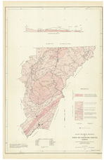
Th is 1s a proviS ional ed 1t 1on Geology and m1neral reso urce
data are from fie ld re conncHs sance Base map compiled f rom US G S - TVA 124000 topog raphic maps, offic1a l I"= I mile county road maps (by State Hig hway
Board of Georg 1a 1n cooperation w1t h Federal Works Age ncy) and AAA aer1al photography indexes.
650,000 F"EET
Cartography and reproduction by Maps & Survtys Branch, TVA
+
(/)
<
i.t.J
:;:
N
Q.
i.t.J
J.....
(/)
+
-
MINERAL
1- Asbes-tos 2- Corundum
3- Fe ldspar
4- Flagstone 5- Gold 6- G r an 1re 7- Gravel 8- Kaolin 9- Kyan1 t e
JO- L 1mestone
RESOURCE
LEGEND
I I -M ica 12 -Monazt+e 15- Ol1v1ne 14 - Q uartz, Amethyst IS- Road Material 16- Sand 17- Serpent1ne 18 - Soapstone !9 .. Talc 20- Verm1CUI1te
X - Mrneral Prospect
~ - Mine
B3"20'
EXPLANATION
bl, Tme{y crysfallme blue to whrfe /;mesfone or marble; occurs as !~nses 1n Brevard schtsf. bs, black graphtf;c schtsf, scaly mtcaceous schist, pl})l l/tf;c shale, grC!_Ywacke..s,& some beds ot quarfLrfe
3440'
gr, gran,te, loca/!y porph_yrd;c (pgr)
CY
w
l')
z
::>
>0 -
hgn, hornblenae gne ;ss and schist
,(5
kms, kyan;te - mrca~garncfrf'erous
~
~ "z
sch r!.f wdh or wdhout graph de
<(
CY
oJ
2
<(
tq, Tallulah Falls quartzde; masstve
fhtcl<: -bedded quarfzde wrfh layers or mtca sch;st,- upper porf;on b;ofde
u
quarfzlfe or graywacke.
I
w
CY
[L
gns, b;oflfe and rnuscovde gne1sses
and sch;..sts (mc!ude some hornblende
gne;ss; mtrud~?d qy younger granrfes)
Normal Contact
Xnown Fdu/t
~--,
r, -.__ M.yor built-up area m fown
' ""'"'/
GEOLOGY AND MINERAL RESOURCES OF
RABUN AND HABERSHAM COUNTIES. GEORGIA
GEORGIA DEPARTMENT OF MINES, MINING AND GEOLOGY IN COOPERATION WITH THE
TENNESSEE VALLEY AUTHORITY
SCALE OF MILES
2
0
2
4
6
1948 83"10'
Geo lo gy by K. H. Teag u e and A. S Furcron, Surve ed 1948
G MS BOO K 50-