- Collection:
- Georgia Government Publications
- Title:
- George W. Andrews Lock and Dam: Chattahoochee River, Alabama-Georgia [Apr. 1977]
- Creator:
- Georgia. Department of Industry, Trade and Tourism
- Contributor to Resource:
- Georgia. Department of Industry, Trade and Tourism
- Publisher:
- Atlanta, Ga. : Georgia. Department of Industry, Trade and Tourism
- Date of Original:
- 1977-04
- Subject:
- Georgia
- Location:
- United States, Georgia, 32.75042, -83.50018
- Medium:
- publications (documents)
- Type:
- Text
- Format:
- application/pdf
- Description:
- Map
- External Identifiers:
- Call Number GA I500.T6 M1 1977 A5
- Metadata URL:
- https://dlg.galileo.usg.edu/id:dlg_ggpd_s-ga-bi500-pt6-bm1-b1977-ba5
- Digital Object URL:
- https://dlg.galileo.usg.edu/do:dlg_ggpd_s-ga-bi500-pt6-bm1-b1977-ba5
- Language:
- eng
- Holding Institution:
- University of Georgia. Map and Government Information Library
- Rights:
-

--- ..
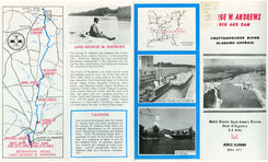
LAKE GEORGE W. ANDREWS
The George W. Andrews Dam deepens the Chattahoochee River without forming a wide-spreading lake. However, fishing has been substantially benefitted, particularly in the tailwater just below the dam, and boating, picnicking and camping are enjoyed on the reservoir.
The Corps of Engineers has built access roads and parking areas at each end of the dam and at three other sites on each side of the lake (see map opposite); boat launching ramps at Coheelee Creek, Odom Creek, Hutchins Landing, Abbie Creek, and Omussee Creek; picnic facilities at Coheelee Creek, Odom Creek, Farmers Landing, Abbie Creek , Omussee Creek, and the west bank dam site area; and tent camping facilities at Abbie Creek and Coheelee Creek. Further facilities will be added as needed. Early County maintains a State-built l aun c hin g ramp about 1/ 4 mile below the dam on the Georgia bank.
SCALE IN MILES
0
I
GEORGE W. ANDREWS LOCK& DAM
EAST BANK DAM SITE AREA
RECREATION AREAS LAKE GEORGE W. ANDREWS
CAUTION
Due to pow e r discharges from the Walter F. Geo rge Dam and gate op erati ons at the Geo rge W. Andrews Dam, there are week-day flu c tu ation in the rese rvoir level resembling fast-ri sing and falling tides. Da il y flu ctuation s ran ge from a maximum of abo ut 16 feet at the Geo rge Dam to a maximum of abo ut 8 feet at the Andrews Dam. In addition, dan gerous currents are c reated in so me lo cations . Levels immediately below the Andrews Dam a l so flu ctuate conside rably.
L.' A
.:r
Ml
I ?'77 H
~~f W. ANDREWS
Otlt AND DAM
WATERWAYS N t::TWORK
CHATTAHOOCHEE RIVER ALABAMA- GEORGIA
Mobile District South Atlantic Division Corps of Enqineers
U.S. Army
111 111
~n li1l1l1l
MOBILE, ALABAMA
APRIL 19 77
N
e Montgomery
SCALE IN MIL ES
25
0
25
!)()
APALACHICOLA - CHATTAHOOCHEE - FLINT RI VER BAS IN
BASIN DEVELOPMENT
T he Geo rge W. Andre ws L oc k and Dam is a fe atu re in the comp re hens ive de ve lopm e nt of the Ap al a c hico l a, Chatta hooc hee and F li nt ri ve r sys te m in F lo rida , Geo rgia and Al abama .
Th e in iti al deve lopm ent, whi ch in cl ud es Lak e Sidn ey Lani e r, the Walte r F. Geo rge , Geo rge W. Andre ws and Jim Woo druff L oc ks and Dams, and improve me nt of th e Ap al a c hico l a Ri ve r, prov id es fo r na vi gati o n in th e lo we r bas in , fl oo d p ro tecti o n in th e upp e r va ll ey, a s ub tan t i al am o unt o f po we r, a regul ate d tream fl o w fo r na\'i gati o n and wate r s upp ly , and three e xte ns ive l a kes fo r recreati o nal u se . Sin ce com p le ti o n o f th e o rig ina l de ve lopm e nt, a fl oo d co ntro l -po we r - fl o w regu1atio n dam ha s bee n co ns tru ct e d a bove Wes t P o int.
Th e George W. Andre ws Lo c k and Dam i s locate d on the Chatta hooch ee Ri ve r about two mi les south of Co lumbia, Al a . , in Hou s ton County , Al a . , and Earl y County , Ga.
It was authorized by Co ngress in 1946 as a pa rt of the com pre hen s ive develop ment of the Apal ac hi co l a, Chattahooche e an d F lin t ri ve r system. Constru ction was begun in 1959 a nd t he loc k was open ed to nav i gation in October 196 2. T he project was essent ia ll y co mplete d in 1963 at a cost o f ap proxim ate ly $13,000 ,000. Fi rst kn own as t he Co lum bi a L oc k and Dam, it was name d in hono r of th e l a te Co ngress man Geor ge W. Andre ws in 1972.
T he stru cture was pl ann ed by the U.S. Army Co rp s of En gin eers and built by private contractors unde r the s up ervis ion of the Corp s . It is op e rate d by Co rp s of En gin eers pe rs onn e l und e r th e direc tion of th e Arm y Di s tric t E ngin eer at Mobil e , Ala .
The George W. Andre ws L ock and Dam co ns i s t s of a lock again s t th e e a s t bank, a gate d s pillway in th e middl e of th e s tre am, and a fi xed-c res t s pillway e xte ndin g to th e wes t bank. Th e lo c k i s a mode rn, hydrauli cally ope rated s tru c ture , with a chamber large e nough to accommodate any tow that can conve ni e ntly navi ga te th e riv e r. The gated section of th e spillway i s equipped with four tainte r gates , whi c h can be ope rated by indi vidual ga te hoi s ts controll e d by pu s h button s .
T he George W. Andre ws Dam backs up th e naturally s hallow Ch a ttahoo chee Rive r to form a navigable channel with a minimum de pth of 9
fee t from the up pe r limit of the J im Woodruff rese rvoi r to th e Wa lte r F. George Lock and Dam near Fo rt Gain es , Ga. It has no powe r ge neration or flood control featu re s .
Th e operation of t he gat e s is coo rdi nated with power operations at the Walte r F . Geo rge Dam in o rde r to mi nimi ze variatio n s in th e wate r l e ve l and to improve nav igation co ndi tions in the upp e r end of the J im Woo dru ff rese rvo ir.
Unde r normal cond itions , the Geo rge W. Andre ws re se rvo ir re main s mos tly within the ori ginal ri ve r ban ks, bu t th e l e ve l flu c tuates co n s id erably . Du rin g floo d s , wate r l eve l s throu ghout th e reservoir are essentially th e same as th ey would have been und e r natura l conditi on s . It i s e xp ec te d that the lock will be flood e d ou t on an a verage of abo ut once every 411z years for a pe ri od of abo u t 5 days .
FOR F URTHER INFORMATION
Ge ne ral :
Di s tri c t Engineer, Mobil e Distri ct , U. S. Army Corp s of Engineers , P . 0 . Box 2288, Mobil e , Ala. 36628; tel ephone number (205) 690-2.50 5
Recre ation:
Resource Mana ge r, Walter F. GeorgeGeorge W. Andrews L akes , U.S. Army Corp s o f Engin eers , P . O. Box 281, F ort Gaines, Ga. 31751; telephone numbe r (912) 768-2462 or 768-2614
At s ite :
L ockm aste r, George W. Andre ws L o ck and Dam, U.S. Army Corps of Engineers , P. 0. Drawe r J, Columbia, Al a. 36 319: tel ephone number (912) 723-3482
I N ~ EET
200 400
I
I
STATISTICS
STR EAM
Dr a in age a r ea ( s qu a r e mi les). Av e r age s tr e am fl ow (c ub ic fee t pe r seco nd )
8,213 10,600
RESERVOI R
Ar ea at normal l eve l ( ac r es ) Volume a t normal l e ve l (a c r e f ee t) Le ngth (riv e r mil es ) . Le ngth of s hor e lin e a t nor ma l l e ve l ( mi l es )
1,540 18, 180
28 . 6 65
LOCK AND DAM
Lo c k I nside c hamb e r dim e ns i ons ( feet) Minim um wa t e r de pth ove r s ill s ( fee t) Maximum lift (f ee t)
82 by 450 13 25
Ga t ed s pillw a" Le ng th ( f ee t) Max i mum he ight o f s tru c tur e f r om found a t i on (f ee t) umb e r of taint e r ga t es Siz e of ga t es (feet)
28 0 92
4 60 by 21
Fix e d- c r es t s pill way
Le ngth (f eet )
340
Maxi mum he ight of str uctu r e from fo und atio n
58
(fee t )
ELEVATIO S ( feet a bove mea n sea l evel)
Norma l l owe r pool
77
Norma l up per pool
102
Top of loc k wa ll s
ll S
Se r vice br i dge ove r g ate d s pil lw ay
142
Top of s pill way gates (c l osed)
10 3
Sp ill way gate sills .
82
Top of f ix e d-crest s pillw ay
10 2