- Collection:
- Georgia Government Publications
- Title:
- Community wildfire protection plan, Grady County : an action plan for wildfire mitigation and conservation of natural resources
- Creator:
- Kelley, Daniel
Fell, Will
Budd, Beryl - Contributor to Resource:
- Georgia. Forestry Commission
- Publisher:
- Cairo, Ga. : Georgia. Forestry Commission
- Date of Original:
- 2018-04
- Subject:
- Wildfires--Georgia--Grady County--Prevention and control
Fire management--Georgia--Grady County - Location:
- United States, Georgia, 32.75042, -83.50018
United States, Georgia, Grady County, 30.87467, -84.23443 - Medium:
- plans (reports)
- Type:
- Text
- Format:
- application/pdf
- External Identifiers:
- OCLC 1200842858
NZ MMS ID 9922172524902931
Call Number F600 .M1 2018 W5 G7 - Metadata URL:
- https://dlg.galileo.usg.edu/id:dlg_ggpd_s-ga-bf600-b-pm1-b2018-bw5-bg7-belec-p-btext
- Digital Object URL:
- https://dlg.galileo.usg.edu/do:dlg_ggpd_s-ga-bf600-b-pm1-b2018-bw5-bg7-belec-p-btext
- Language:
- eng
- Holding Institution:
- University of Georgia. Map and Government Information Library
- Rights:
-

A Program of the Georgia Forestry Commission with support from the U.S. Forest Service
APRIL 2018 1
Prepared by; Daniel Kelley, Chief Ranger, Grady County Will Fell, CWPP Specialist (Initial Plan 2009) Beryl Budd, Wildfire Prevention Specialist (Revised 2018)
Georgia Forestry Commission 29 17th Ave NW Cairo, GA 39828
The following report is a collaborative effort among various entities. The representatives listed below comprise the core decision-making team responsible for this report and mutually agree on the plan's contents:
Richard Phillips Chief Grady County VFD EMA Director (229) 377-0620 gradychief1@gmail.com
Daniel Kelley Chief Ranger, Grady County Forestry Unit (229) 377-3951 rkirksey@gfc.state.ga.us.
Darren Martin Assistant District Manager, Camilla District (229) 522-3580 fsumner@gfc.state.ga.us
Don Towne Chief, Cairo Fire Dept. (229) 377-3293 dtowne@cairocity.net.
Al Akridge Chief, Whigham Fire Dept. (229) 762-4171 cashandcarry@windstream.net
Mark Bryant Chief, Reno Fire Dept. (229) 221-1846 mark.bt@live.com
2
PLAN CONTENTS
I. Objectives & Community Collaboration ...............................................................................4 II. Community & Wildfire History ...............................................................................................5 III. County Base Maps.................................................................................................................12 IV. Community Wildfire Risk Assessment .................................................................................15 V. Southern Wildfire Risk Assessment & Risk Hazards Map ...................................................18 VI. Prioritized Mitigation Recommendations .............................................................................22 VII. Action Plan ..........................................................................................................................26 VIII. Mitigation Assistance & Grant Funding... .................................................................... .29 IX. Glossary................................................................................................30
X. Sources of Information...............................................................................32 Appended Documents: Grady County Southern Wildfire Risk Assessment Summary Report
3
W I L D F I R E P R O T E C T I O N P L A N : A N A C T I O N P L A N F O R W I L D F I R E M I T I G A T I O N
I. OBJECTIVES & COMMUNITY COLLABORATION
The mission of the following report is to set clear priorities for the implementation of wildfire mitigation in Grady County. The plan includes prioritized recommendations for the appropriate types and methods of fuel reduction and structure ignitability reduction that will protect this community and its essential infrastructure. It also includes a plan for wildfire suppression. Specifically, the plan includes community-centered actions that will:
Educate citizens on wildfire, its risks, and ways to protect lives and properties, Support fire rescue and suppression entities, Focus on collaborative decision-making and citizen participation, Develop and implement effective mitigation strategies, and Develop and implement effective community ordinances and codes.
An initial meeting was held on Jan 8th 2009 at the Grady County Fire Department attended by the following core planning team;
Will Fell Randy Kirksey Wayne Hadden James L Davis Al Akridge Mark Bryant Forrest Sumner
GFC CWPP Specialist GFC Chief Ranger Grady County Fire Chief Grady County VFD Lt. Cairo Fire Dept Fire Chief Whigham VFD Fire Chief Reno VFD GFC District Ranger
After an initial discussion of the processes and goals we hope to accomplish with this report, it was decided that we would identify and evaluate selected high risk communities and areas within the wildland urban interface. At the completion of this we would reconvene and discuss and evaluate the completed community wildfire risk assessments. It was further decided that we would provide for mitigation recommendations for each of the ten fire districts. The chiefs of the ten fire departments in the county assessed their districts and reconvened on July 8th 2009 for the purpose of completing the following:
Risk Assessment
Assessed wildfire hazard risks and prioritized mitigation actions.
Fuels Reduction
Identified strategies for coordinating fuels treatment projects.
Structure Ignitability
Identified strategies for reducing the ignitability of structures within the Wildland interface.
Emergency Management Forged relationships among local government and fire districts and developed/refined a pre-suppression plan.
Education and Outreach Developed strategies for increasing citizen awareness and action and to conduct homeowner and community leader workshops.
4
W I L D F I R E P R O T E C T I O N P L A N : A N A C T I O N P L A N F O R W I L D F I R E M I T I G A T I O N
II. COMMUNITY & WILDFIRE HISTORY
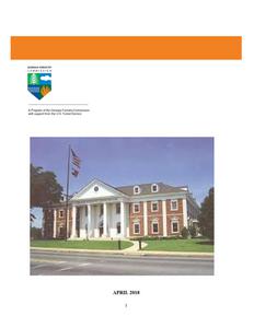
Grady County, on the southwest border of Georgia, is the state's 139th county. Created in 1905 from 458 square miles of Decatur and Thomas counties, it was named after Henry W. Grady, prominent editor of the Atlanta Constitution and national spokesman for the "New South." Located along Georgia's border with Florida, Grady County is part of the "Plantation Trace Travel Region," which includes several southwest Georgia counties. Seminole Indians originally held the land now encompassed by Grady County. The first white settlers traveled from the Carolinas along Indian trails from the South Carolina line near Augusta, across the state to Macon, and down to the southwest. Among the settlers was William Hawthorne, a Baptist minister and explorer who arrived in the 1820s and settled his family about three miles south of present-day Cairo, on Tired Creek. Some of his friends in North Carolina followed him and settled farther south, around the present-day town of Calvary. Additionally a number of white Florida settlers moved to Georgia seeking safety when the Seminole Wars began. The county seat, Cairo, was previously called Miller's Station for a stagecoach stop named after a nearby settler, Henry Miller. In 1859 the Atlantic and Gulf Railroad began running through the settlement on its route from Screven to Thomasville, and in 1867 it established Railroad Station Number 20, called the Cairo Station after a nearby post office. Lots were sold to prospective townspeople beginning in 1866, and the town was incorporated in 1870. When Grady County
was created, Cairo was designated the county seat. The police department currently occupies the old depot, built in 1905. The first courthouse, built in 1908, burned down in 1980; a new courthouse was soon built on the same spot. Cairo and Whigham are the two incorporated cities in Grady County. Whigham, originally called Harrell's Station, took its current name in 1880 for Robert Whigham, the owner of a
Grady County Courthouse large local mercantile store. Other communities in Grady County are Beachton, Calvary, Pine Park, and Reno. Calvary is home to an annual "Mule Day," which swells the population of the town from less than 200 to 60,000 or more. Before the Civil War (1861-65), settlers made their living in agriculture. The sandy loam of the area supported a variety of food crops, and land was cleared of pine forests to allow for farming. Until railroad transportation allowed them to market their goods, most inhabitants lived by subsistence farming. This started changing with Reconstruction, when sawmills were established, rail transportation became routine, and the county broadened its economic base to include forest products as well as market crops. A satellite campus of Southwest Georgia Technical College (later Southern Regional Technical College) opened in Cairo in 2006.
5
W I L D F I R E P R O T E C T I O N P L A N : A N A C T I O N P L A N F O R W I L D F I R E M I T I G A T I O N
Notable persons from the county include the writer Vereen Bell and baseball player Jackie Robinson.
Some points of interest in the county include the Birdsong Nature Center, a nonprofit nature preserve and education center created in 1986 from the former Birdsong Plantation, which was placed on the National Register of Historic Places in 1995; Cairo Commercial Historic District, also placed on the National Register of Historic Places in 1994; and Pebble Hill Plantation, a 7,000-acre estate owned in the 1930s by Kate Harvey of Cleveland, Ohio (niece of influential senator Marc Hanna of Ohio). Used by Harvey Birdsong Nature Center as a winter retreat, Pebble Hill was visited often by members and friends of the Franklin D. Roosevelt family and was home to a famous herd of Jersey cattle, the Pebble Hill Herd. Pebble Hill was added to the National Register in 1990. According to the 2010 U.S. census, the population of Grady County is 25,011, an increase from the 2000 population of 23,659.
Wildfire History
About 57% of Grady County is still in woodland despite the large agricultural presence in the county. Much of this woodland is in large plantations managed for hunting and recreation or as woodlots on farms. These woodlands are routinely burned every few years keeping wildland fuel levels down. Unfortunately much of what doesn't get prescribed burned are wildlands in close proximity of residential areas or small outlying communities. With the exception of a few large blocks of plantation woodland in the southeastern portion of the county, there are homes scattered throughout the county. Along with several subdivisions and small communities, the risk from wildland urban interface is fairly substantial and general throughout the county.
Over the past fifty years, Grady County has averaged almost 60 reported wildland fires per year and 63% of these have occurred during the months of December, January, February, and March. These fires have burned an average of 267 acres annually. Of this annual acreage burned, 74% was lost during the above four months. Despite the advent of the outdoor burning permit law about 25 years ago, the numbers of fires have slightly increased over the years as more residences have moved out of towns into the Wildland Urban Interface.
During the last 10 years, FY 2007 2016, the leading cause of fires was debris burning accounting for 62% of the fires and 74% of the acres burned. Machine use was the next leading cause with 13% of the fires and 9% of the acres lost. Incendiary (arson) was 3rd major cause with 7% of the fires and 5% of total acreage burned. More detailed records over the past 10 years show that over 45% of these debris fires originated from escapes from prescribed burning and 27% from household or residential debris burning. More detailed wildfire data for FY 2017 and FY 2007 2016 is included on the following pages 7 thru 11.
6
W I L D F I R E P R O T E C T I O N P L A N : A N A C T I O N P L A N F O R W I L D F I R E M I T I G A T I O N
County = Grady
Cause
Fires
Campfire
Campfire
3
Children
Children
1
Debris: Ag Fields, Pastures, Orchards, Etc
Debris: Ag Fields, Pastures, Orchards, Etc
2
Debris: Construction Land Clearing
Debris: Construction Land Clearing
2
Debris: Escaped Prescribed Burn
Debris: Escaped Prescribed Burn
9
Debris: Household Garbage Debris: Household Garbage
0
Debris: Other
Debris: Other
1
Debris: Residential, Leafpiles, Yard, Etc
Debris: Residential, Leafpiles, Yard, Etc
11
Debris: Site Prep - Forestry Related
Debris: Site Prep - Forestry Related
5
Incendiary
Incendiary
4
Machine Use
Machine Use
2
Miscellaneous: Other
Miscellaneous: Other
0
Miscellaneous: Power lines/Electric fences
Miscellaneous: Power lines/Electric fences
0
Railroad
Railroad
0
Undetermined
Undetermined
5
Totals for County: Grady Year: 2017
45
Acres
0.59 0.10 7.15
0.20
44.36 0.00 0.86 19.25
12.31 208.19
0.88 0.00 0.00 0.00 72.96 366.85
Fires 5 Yr Avg 1.40
0.60
2.00
Acres 5 Yr Avg 2.07
0.58
5.22
1.40
1.27
8.80 45.97
0.40
0.12
0.60
1.37
5.40 11.21
2.60
9.09
1.40 42.00
3.20
4.81
0.60
1.31
0.80
0.75
0.20
0.02
2.60 18.44
32.00 144.22
7
W I L D F I R E P R O T E C T I O N P L A N : A N A C T I O N P L A N F O R W I L D F I R E M I T I G A T I O N
Year
2007 2008 2009 2010 2011 2012 2013 2014 2015 2016
Acreage Burned /Number of Fires For Grady County For FY 2007-2016
Acreage Burned Number of Fires Average Size
253.69
100
2.54
97.22
45
2.16
62.01
52
1.19
281.09
17
16.53
328.22
93
3.53
121.31
55
2.21
101.46
31
3.27
34.68
21
1.65
102.27
33
3.10
115.84
30
3.86
Statewide Average Size
18.64 4.56 3.90 3.93 17.56 5.08 4.53 5.02 4.42 6.29
8
W I L D F I R E P R O T E C T I O N P L A N : A N A C T I O N P L A N F O R W I L D F I R E M I T I G A T I O N
9
W I L D F I R E P R O T E C T I O N P L A N : A N A C T I O N P L A N F O R W I L D F I R E M I T I G A T I O N
10
W I L D F I R E P R O T E C T I O N P L A N : A N A C T I O N P L A N F O R W I L D F I R E M I T I G A T I O N
11
W I L D F I R E P R O T E C T I O N P L A N : A N A C T I O N P L A N F O R W I L D F I R E M I T I G A T I O N
III. COUNTY BASE MAP
12
W I L D F I R E P R O T E C T I O N P L A N : A N A C T I O N P L A N F O R W I L D F I R E M I T I G A T I O N
13
W I L D F I R E P R O T E C T I O N P L A N : A N A C T I O N P L A N F O R W I L D F I R E M I T I G A T I O N
14
W I L D F I R E P R O T E C T I O N P L A N : A N A C T I O N P L A N F O R W I L D F I R E M I T I G A T I O N
IV. COMMUNITY WILDFIRE RISK ASSESSMENT
The Wildland-Urban Interface
There are many definitions of the Wildland-Urban Interface (WUI), however from a fire management perspective it is commonly defined as an area where structures and other human development meet or intermingles with undeveloped wildland or vegetative fuels. As fire is dependent on a certain set of conditions, the National Wildfire Coordinating Group has defined the wildland-urban interface as a set of conditions that exists in or near areas of wildland fuels, regardless of ownership. This set of conditions includes type of vegetation, building construction, accessibility, lot size, topography and other factors such as weather and humidity. When these conditions are present in certain combinations, they make some communities more vulnerable to wildfire damage than others. This "set of conditions" method is perhaps the best way to define wildland-urban interface areas when planning for wildfire prevention, mitigation, and protection activities.
There are three major categories of wildland-urban interface. Depending on the set of conditions present, any of these areas may be at risk from wildfire. A wildfire risk assessment can determine the level of risk.
1. "Boundary" wildland-urban interface is characterized by areas of development where homes, especially new subdivisions, press against public and private wildlands, such as private or commercial forest land or public forests or parks. This is the classic type of wildland-urban interface, with a clearly defined boundary between the suburban fringe and the rural countryside.
2. "Intermix" wildland-urban interface areas are places where improved property and/or structures are scattered and interspersed in wildland areas. These may be isolated rural homes or an area that is just beginning to go through the transition from rural to urban land use.
3. "Island" wildland-urban interface, also called occluded interface, are areas of wildland within predominately urban or suburban areas. As cities or subdivisions grow, islands of undeveloped land may remain, creating remnant forests. Sometimes these remnants exist as parks, or as land that cannot be developed due to site limitations, such as wetlands.
15
W I L D F I R E P R O T E C T I O N P L A N : A N A C T I O N P L A N F O R W I L D F I R E M I T I G A T I O N
The wildland fire risk assessments conducted in 2009 by the Grady County Fire Departments returned an average score of 81, placing Grady County in the "moderate" hazard range. The risk assessment instrument used to evaluate wildfire hazards to Grady County's WUI was the Woodland Community Wildfire Hazard Risk Assessment Checklist. The instrument takes into consideration accessibility, vegetation (based on fuel models), topography, roofing assembly, building construction, and availability of fire protection resources, placement of gas and electric utilities, and additional rating factors. The following factors contributed to the wildfire hazard score for Grady County:
Dead end roads with inadequate turn arounds. Narrow roads without drivable shoulders. Roads and entrances to communities too narrow for equipment. Long, narrow, and poorly labeled driveways. Minimal defensible space around structures. Homes with wooden siding and roofs with heavy accumulations of vegetative debris. Lack of non flammable skirting around mobile homes. No pressurized or non-pressurized water systems available. Dry hydrants and drafting sources unusable. Above ground utilities. Large, adjacent areas of forest or wildlands. Undeveloped lots comprise half the total lots in many rural communities. High occurrence of wildfires in several locations.
Wildland Urban Interface (WUI) is described as the area where structures and other human improvements meet and intermingle with undeveloped wildland or vegetative fuels.
16
W I L D F I R E P R O T E C T I O N P L A N : A N A C T I O N P L A N F O R W I L D F I R E M I T I G A T I O N
Summary of Community Assessments.
Community Site Building
Community Fire Dept Design
Hazard Construction
Additional Factors
Overall Score
Hazard Rating
City of Cairo Cairo FD
5
35
5
Grady Hdqtrs Grady
District
Hdqtrs FD
5
20
10
Beachton
Beachton
District
VFD
8
42
20
Beachton
Beachton
Place
VFD
11
62
15
Calvary
Calvary
District
VFD
6
26
10
Calvary
Quail Ridge VFD
10
55
15
Midway
Midway
District
VFD
9
10
12
Pine Level
Pine Level
District
VFD
6
35
15
Pine Park
Pine Park
District
VFD
6
17
10
Pine Park
Deer Lake
VFD
18
36
5
Pine Park
Mill Creek
VFD
11
59
5
Pine Park
Pine Park
Estates
VFD
13
40
10
Southern Terr Pine Park
/ Virginia Cir VFD
6
11
5
Temple
Pine Park
Terrace
VFD
6
23
5
Reno District Reno VFD
8
11
5
Oakland Drive Reno VFD
10
32
15
Spence
Spence
District
VFD
15
32
10
Banks Rd /
Stagecoach Spence
Rd
VFD
15
42
25
Spence
Stagecoach Rd VFD
15
25
20
Whigham
Whigham
District
VFD
6
52
30
Whigham
Bun Lane
VFD
12
46
20
Whigham
Dodge Lane VFD
11
58
20
Whigham
Nottingham St VFD
10
47
20
Average
2
47
Low Risk
5
40
Low Risk
Moderate
49
119 Risk
Moderate
16
104 Risk
9
51
Low Risk
Moderate
37
117 Risk
0
31
Low Risk
Moderate
34
90
Risk
8
41
Low Risk
Moderate
31
90
Risk
Moderate
31
106 Risk
Moderate
36
99
Risk
22
44
Low Risk
29
63
Low Risk
5
29
Low Risk
Moderate
22
78
Risk
16
73
Low Risk
Moderate
29
111 Risk
Moderate
34
94
Risk
Moderate
9
97
Risk
Moderate
21
99
Risk
Moderate
36
125 Risk
Moderate
32
109 Risk
Moderate
81
Risk
17
W I L D F I R E P R O T E C T I O N P L A N : A N A C T I O N P L A N F O R W I L D F I R E M I T I G A T I O N
V. SOUTHERN WILDFIRE RISK ASSESSMENT & RISK HAZARD MAPS
The Southern Wildfire Risk Assessment tool, developed by the Southern Group of State Foresters, was released to the public in July 2014. This tool allows users of the Professional Viewer application of the Southern Wildfire Risk Assessment (SWRA) web Portal (SouthWRAP) to define a specific project area and summarize wildfire related information for this area. A detailed risk summary report is generated using a set of predefined map products developed by the Southern Wildfire Risk Assessment project which have been summarized explicitly for the user defined project area. A risk assessment summary was generated for Grady County. The SouthWRAP (SWRA) products included in this report are designed to provide the information needed to support the following key priorities:
Identify areas that are most prone to wildfire
Identify areas that may require additional tactical planning, specifically related to mitigation projects and Community Wildfire Protection Planning
Provide the information necessary to justify resource, budget and funding requests
Allow agencies to work together to better define priorities and improve emergency response, particularly across jurisdictional boundaries
Define wildland communities and identify the risk to those communities
Increase communication and outreach with local residents and the public to create awareness and address community priorities and needs
Plan for response and suppression resource needs
Plan and prioritize hazardous fuel treatment programs
Community Protection Zones map from the Grady County SWRA
18
W I L D F I R E P R O T E C T I O N P L A N : A N A C T I O N P L A N F O R W I L D F I R E M I T I G A T I O N
ABOVE: Wildland Urban Interface (WUI) map BELOW: WUI acres (left) and WUI Population (right)
19
W I L D F I R E P R O T E C T I O N P L A N : A N A C T I O N P L A N F O R W I L D F I R E M I T I G A T I O N
ABOVE: Wildland Urban Interface (WUI) Risk map BELOW: WUI Risk Index - Acres
20
W I L D F I R E P R O T E C T I O N P L A N : A N A C T I O N P L A N F O R W I L D F I R E M I T I G A T I O N
ABOVE: Fire Intensity Scale map BELOW: Flame Length map
21
W I L D F I R E P R O T E C T I O N P L A N : A N A C T I O N P L A N F O R W I L D F I R E M I T I G A T I O N
VI. PRIORITIZED MITIGATION RECOMMENDATIONS
Executive Summary
The following recommendations were developed by the Grady County CWPP Core team as a result of surveying and assessing fuels and structures and by conducting meetings and interviews with county and city officials. A priority order was determined based on which mitigation projects would best reduce the hazard of wildfire in the assessment area.
Proposed Community Hazard and Structural Ignitability Reduction Priorities
Primary Protection for Community and Its Essential Infrastructure
Treatment Area
Treatment Types
Treatment Method(s)
1. All Structures
Create minimum of 30feet of defensible space**
Trim shrubs and vines to 30 feet from structures, trim overhanging limbs, replace flammable plants near homes with less flammable varieties, remove vegetation around chimneys.
2. Applicable Structures
Reduce structural ignitability**
Clean flammable vegetative material from roofs and gutters, store firewood appropriately, install skirting around raised structures, store water hoses for ready access, replace pine straw and mulch around plantings with less flammable landscaping materials.
3. Community Clean-up Day
National Wildfire Preparedness Day is the 1st Saturday in May.
Cutting, mowing, chipping, pruning**
Cut, prune, and mow vegetation in shared community spaces. Use a chipper to reduce fuel.
4. Road Signage 5. Road Access 6. Subdivision Access
At Replacement
Identify needed road improvements Alternate exits
New road signage with minimum 4 inch reflective lettering on non-flammable poles. Dead end (no outlet or turnaround) should be prominently tagged.
As roads are upgraded, widen to minimum standards with at least 50 foot diameter cul-de-sacs.
Work with developers to identify and create alternate access and exits routes to subdivisions and communities with only one way in and out.
22
W I L D F I R E P R O T E C T I O N P L A N : A N A C T I O N P L A N F O R W I L D F I R E M I T I G A T I O N
7. Codes and Ordinances
Examine existing codes and ordinances. Utilize the International Wildland Interface Code (IWUIC). This code was approved by Georgia Legislation in 2014 for counties to use in high hazard areas.
Amend and enforce existing building codes as they relate to skirting, propane tank locations, public nuisances (trash/debris on property), Property address marking standards and other relevant concerns
At such time as the development of zoning, planning and subdivision ordinances become practical include fire department and emergency services input in the design of these.
Proposed Community Wildland Fuel Reduction Priorities
Treatment Area
Treatment Types
Treatment Method(s)
1. Adjacent WUI Lands
Reduce hazardous fuels
Encourage prescribed burning for private landowners and industrial timberlands particularly adjacent to residential areas.
2. Existing Fire Lines
Reduce hazardous fuels Clean and re-harrow existing lines.
Proposed Improved Community Wildland Fire Response Priorities
1. Water Sources
Dry Hydrants
Inspect, maintain and improve access to existing dry hydrants. Review need for placement of additional dry hydrants. Add signage along road to mark the hydrants.
2. Fire Stations
Equipment
Wildland hand tools. Lightweight Wildland PPE Gear. Larger capacity hose. Investigate need for "brush" trucks.
3. Personnel
Training
Obtain Wildland Fire Suppression training for Fire Personnel.
**Actions to be taken by homeowners and community stakeholders
23
W I L D F I R E P R O T E C T I O N P L A N : A N A C T I O N P L A N F O R W I L D F I R E M I T I G A T I O N
Proposed Education and Outreach Priorities
1. Conduct "How to Have a Firewise Home" Workshop for Grady County Residents
Set up and conduct a workshop for homeowners that teach the principles of making homes and properties safe from wildfire. Topics for discussion include defensible space, landscaping, building construction, etc. Workshop will be scheduled for evenings or weekends when most homeowners are available and advertised through local media outlets. Distribute materials promoting firewise practices and planning through homeowners associations, schools, civic groups and local community and governmental meetings.
2. Conduct "Firewise" Workshop for Community Leaders
Arrange for GFC Firewise program to work with local community leaders and governmental officials on the importance of "Firewise Planning" in developing ordinances and codes as the county as the need arises. Identify "Communities at Risk" within the county for possible firewise community recognition.
3. Spring Clean-up Event (National Wildfire Preparedness Day 1st Saturday in May)
Conduct clean-up event every spring involving the Georgia Forestry Commission, Cairo and Grady County Fire Departments and community residents. Set up information table with educational materials and refreshments. Initiate the event with a morning briefing by GFC Firewise coordinator and local fire officials detailing plans for the day and safety precautions. Activities to include the following:
Clean flammable vegetative material from roofs and gutters
Trim shrubs and vines to 30 feet away from structures
Trim overhanging limbs Clean hazardous or flammable debris from adjacent properties Celebrate the work with a community cookout, with Community officials, GFC and Cairo and Grady County Fire Departments discussing and commending the work accomplished. 4. Informational Packets
Develop and distribute informational packets to be distributed by realtors and insurance agents and included with building permits. Included in the packets are the following:
Be Firewise Around Your Home Firewise Guide to Landscape and Construction
Firewise Communities USA materials Ready Set Go program materials Fire Adapted Community materials
24
W I L D F I R E P R O T E C T I O N P L A N : A N A C T I O N P L A N F O R W I L D F I R E M I T I G A T I O N
5. Wildfire Protection Display Create and exhibit a display for the general public at local events and festivals. Display can be independent or combined with the Georgia Forestry Commission display.
6. Media Invite the Cairo Messenger and other area news media to community "Firewise" functions for news coverage and regularly submit press releases documenting wildfire risk improvements in Grady County. Utilize social media and radio to reach new audiences.
Prescribed burning is a best management practice to reduce hazardous fuel buildup. The Georgia Forestry Commission can assist by developing a prescribed burning plan, installation of firebreaks, and can provide equipment standby and burning assistance when personnel are available.
Pictured here is a Georgia Forestry Commission masticater mowing forest understory for fuel reduction. This type of mitigation work is effective in areas where prescribed burning is not practical. The Georgia Forestry Commission and private contractors can provide this service.
25
W I L D F I R E P R O T E C T I O N P L A N : A N A C T I O N P L A N F O R W I L D F I R E M I T I G A T I O N
VII. ACTION PLAN
Roles and Responsibilities The following roles and responsibilities have been developed to implement the action plan:
Role
Responsibility
Hazardous Fuels and Structural Ignitability Reduction
Grady County Wildland Urban Interface Fire Council
Create this informal team or council comprised of residents, GFC officials, Cairo and Grady County Fire Department officials, code enforcement, road superintendent and the EMA Director for Grady county. Meet periodically to review progress towards mitigation goals, appoint and delegate special activities, work with federal, state, and local officials to assess progress and develop future goals and action plans. Work with residents to implement projects and firewise activities.
Key Messages to focus on
1 Defensible Space and Firewise Landscaping 2 Debris Burning Safety 3 Firewise information for homeowners 4 Prescribed burning benefits
Communications objectives
1 Create public awareness for fire danger and defensible space issues
2 Identify most significant human cause fire issues
3 Enlist public support to help prevent these causes
4 Encourage people to employ fire prevention and defensible spaces in their communities.
Target Audiences
1 Homeowners 2 Forest Landowners and users 3 Civic Groups 4 School Groups
Methods
1 News Releases 2 Personal Contacts 3 Key messages and prevention tips 4 Visuals such as signs, brochures and posters
26
W I L D F I R E P R O T E C T I O N P L A N : A N A C T I O N P L A N F O R W I L D F I R E M I T I G A T I O N
Spring Clean-up Day (National Wildfire Preparedness Day)
Event Coordinator
Coordinate day's events and schedule, catering for cookout, guest attendance, and moderate activities the day of the event.
Event Treasurer
Collect funds from residents to cover food, equipment rentals, and supplies.
Publicity Coordinator
Advertise event through neighborhood newsletter, letters to officials, and public service announcements (PSAs) for local media outlets. Publicize post-event through local paper and radio PSAs.
Work Supervisor
Develop volunteer labor force of community residents; develop labor/advisory force from Georgia Forestry Commission, Cairo and Grady County Fire Departments, and Emergency Management Agency. Procure needed equipment and supplies. In cooperation with local city and county officials, develop safety protocol. Supervise work and monitor activities for safety the day of the event.
Funding Needs The following funding is needed to implement the action plan:
Project
Estimated Cost Potential Funding Source(s)
1. Create a minimum of 30 feet of defensible space around structures
Varies
Residents will supply labor and fund required work on their own properties.
2. Reduce structural ignitability by cleaning flammable vegetation from roofs and gutters; appropriately storing firewood, installing skirting around raised structures, storing water hoses for ready access, replacing pine needles and mulch around plantings with less flammable material.
Varies
3. Amend codes and ordinances to provide better driveway access, increased visibility of house numbers, properly stored firewood, minimum defensible space brush clearance, required Class A roofing materials and skirting around raised structures, planned maintenance of community lots.
No Cost
Residents will supply labor and fund required work on their own properties.
To be adopted by city and county government.
4. Spring Cleanup Day
Varies
Community Business Donations.
5. Fuel Reduction Activities
$35 / Acre
FEMA & USFS Grants
27
W I L D F I R E P R O T E C T I O N P L A N : A N A C T I O N P L A N F O R W I L D F I R E M I T I G A T I O N
Assessment Strategy
To accurately assess progress and effectiveness for the action plan, the Grady County WUI Fire Council will implement the following:
Annual wildfire risk assessment will be conducted to re-assess wildfire hazards and prioritize needed actions.
Mitigation efforts that are recurring (such as mowing, burning, clearing of defensible space) will be incorporated into an annual renewal of the original action plan.
Mitigation efforts that could not be funded in the requested year will be incorporated into the annual renewal of the original action plan.
Continuing educational and outreach programs will be conducted and assessed for effectiveness. Workshops will be evaluated based on attendance and post surveys that are distributed by mail 1month and 6 months following workshop date.
The Grady County WUIFC will publish an annual report detailing mitigation projects initiated and completed, progress for ongoing actions, funds received, funds spent, and in-kind services utilized. The report will include a "state of the community" section that critically evaluates mitigation progress and identifies areas for improvement. Recommendations will be incorporated into the annual renewal of the action plan.
An annual survey will be distributed to residents soliciting information on individual mitigation efforts on their own property (e.g., defensible space). Responses will be tallied and reviewed at the next Grady County WUIFC meeting. Needed actions will be discussed and delegated.
This plan should become a working document that is shared by local, state, and federal agencies that will use it to accomplish common goals. An agreed-upon schedule for meeting to review accomplishments, solve problems, and plan for the future should extend beyond the scope of this plan. Without this follow up this plan will have limited value.
28
W I L D F I R E P R O T E C T I O N P L A N : A N A C T I O N P L A N F O R W I L D F I R E M I T I G A T I O N
VII. MITIGATION ASSISTANCE & GRANT FUNDING
Community Protection Grant: US Forest Service sponsored prescribed fire program. Communities with "at-risk" properties that lie within ten miles of a National Forest, National Park Service or Bureau of Land Management tracts may apply with the Georgia Forestry Commission to have their land prescribe burned free-of-charge. Forest mastication, where it is practical with Georgia Forestry Commission equipment, is also available under this grant program.
FEMA Mitigation Policy MRR-2-08-01: through GEMA Hazard Mitigation Grant Program (HMGP) and Pre-Disaster Mitigation Program (PDM).
1. To provide technical and financial assistance to local governments to assist in the implementation of long term, cost effective hazard mitigation accomplishments.
2. This policy addresses wildfire mitigation for the purpose of reducing the threat to allrisk structures through creating defensible space, structural protection through the application of ignition resistant construction and limited hazardous fuel reduction to protect life and property.
3. With a completed registered plan (addendum to the State Plan) counties can apply for pre-mitigation funding. They will also be eligible for HMGP funding if the county is declared under a wildfire disaster.
Georgia Forestry Commission: Plowing and prescribed burning assistance, as well as forest mastication, can be obtained from the GFC as a low-cost option for mitigation efforts.
The Georgia Forestry Commission Firewise Community Mitigation Assistance Grants Nationally recognized Firewise Communities can receive up to $5000 grants to help address potential wildfire risk reduction projects. Grant submission can be made through local Georgia Forestry Commission offices or your Regional Wildfire Prevention Specialist.
The International Association of Fire Chiefs (IAFC) and American International Group, Inc. (AIG) offer grants to assist local fire departments in establishing or enhancing their community fuels mitigation programs while educating members of the community about community wildfire readiness and encouraging personal action.
29
W I L D F I R E P R O T E C T I O N P L A N : A N A C T I O N P L A N F O R W I L D F I R E M I T I G A T I O N
IX. GLOSSARY
Community-At-Risk A group of two or more structures whose proximity to forested or wildland areas places homes and residents at some degree of risk.
Critical Facilities Buildings, structures or other parts of the community infrastructure that require special protection from an approaching wildfire.
CWPP The Community Wildfire Protection Plan.
Defensible Space The immediate landscaped area around a structure (usually a minimum of 30 ft.) kept "lean, clean and green" to prevent an approaching wildfire from igniting the structure.
Dry Hydrant - A non-pressurized pipe system permanently installed in existing lakes, ponds and streams that provides a suction supply of water to a fire department tank truck.
FEMA The Federal Emergency Management Agency whose mission is to support our citizens and first responders to ensure that as a nation we work together to build, sustain, and improve our capability to prepare for, protect against, respond to, recover from, and mitigate all hazards.
Fire Adapted Community A community fully prepared for its wildfire risk by taking actions to address safety, homes, neighborhoods, businesses and infrastructure, forest, parks, open spaces, and other community assets.
Firewise Program A national initiative with a purpose to reduce structural losses from wildland fires.
Firewise Community/USA A national recognition program for communities that take action to protect themselves from wildland fire. To qualify a community must have a wildfire risk assessment by the Georgia Forestry Commission, develop a mitigation action plan, have an annual firewise mitigation/education event, have dedicated firewise leadership, and complete the certification application.
Fuels All combustible materials within the wildland/urban interface or intermix including, but not limited to, vegetation and structures.
Fuel Modification Any manipulation or removal of fuels to reduce the likelihood of ignition or the resistance to fire control.
Hazard & Wildfire Risk Assessment An evaluation to determine an area's (community's) potential to be impacted by an approaching wildland fire.
Healthy Forests Initiative - Launched in August 2002 by President Bush (following passage of the Healthy Forests Restoration Act by Congress) with the intent to reduce the risks severe wildfires pose to people, communities, and the environment.
30
W I L D F I R E P R O T E C T I O N P L A N : A N A C T I O N P L A N F O R W I L D F I R E M I T I G A T I O N
Home Ignition Zone (Structure Ignition Zone) - Treatment area for wildfire protection. The "zone" includes the structure(s) and their immediate surroundings from 0-200 ft. Mitigation An action that moderates the severity of a fire hazard or risk.
National Fire Plan National initiative, passed by Congress in the year 2000, following a landmark wildland fire season, with the intent of actively responding to severe wildland fires and their impacts to communities while ensuring sufficient firefighting capacity for the future.
National Fire Protection Association (NFPA) - An international nonprofit organization established in 1896, whose mission is to reduce the worldwide burden of fire and other hazards on the quality of life by providing and advocating consensus codes and standards, research, training, and education.
National Wildfire Preparedness Day Started in 2014 by the National Fire Protection Association as a day for communities to work together to prepare for the approaching wildfire season. It is held annually on the first Saturday in May.
Prescribed Burning (prescribed fire) The use of planned fire that is deliberately set under specific fuel and weather condition to accomplish a variety of management objectives and is under control until it burns out or is extinguished.
Ready, Set, Go - A program fire services use to help homeowners understand wildfire preparedness, awareness, and planning procedures for evacuation.
Southern Group of State Foresters Organization whose members are the agency heads of the forestry agencies of the 13 southern states, Puerto Rico and the Virgin Islands.
Stakeholders Individuals, groups, organizations, businesses or others who have an interest in wildland fire protection and may wish to review and/or contribute to the CWPP content.
Wildfire or Wildland Fire An unplanned and uncontrolled fire spreading through vegetative fuels.
Wildland/Urban Interface - The presence of structures in locations in which the authority having jurisdiction (AHJ) determines that topographical features, vegetation, fuel types, local weather conditions and prevailing winds result in the potential for ignition of the structures within the area from flames and firebrands from a wildland fire (NFPA 1144, 2008).
31
W I L D F I R E P R O T E C T I O N P L A N : A N A C T I O N P L A N F O R W I L D F I R E M I T I G A T I O N
X. SOURCES OF INFORMATION
Publications/Brochures/Websites: FIREWISE materials can be ordered at www.firewise.org Georgia Forestry Commission www.georgiafirewise.org Examples of successful wildfire mitigation programs can be viewed at the website for National Database of State and Local wildfire Hazard Mitigation Programs sponsored by the U.S. Forest Service and the Southern Group of State Foresters www.wildfireprograms.com Information about a variety of interface issues (including wildfire) can be found at the USFS website for Interface South: www.interfacesouth.org Information on codes and standards for emergency services including wildfire can be found at www.nfpa.org Information on FEMA Assistance to Firefighters Grants (AFG) can be found at www.firegrantsupport.com Information on National Fire Plan grants can be found at http://www.federalgrantswire.com/national-fire-plan--rural-fire-assistance.html Southern Wildfire Risk Assessment website SouthWRAP www.SouthernWildfireRisk.com Fire Adapted Communities www.fireadapted.org Ready, Set, Go www.wildlandfirersg.org National Wildfire Preparedness Day www.wildfireprepday.org
Appended Documents:
Grady County Southern Wildfire Risk Assessment Summary Report (SWRA) Grady County Wildfire assessment scoresheets All files that make up this plan are available in an electronic format from the Georgia Forestry Commission
32
Georgia Forestry Commission 5645 Riggins Mill Rd. Dry Branch, GA 31020
1-800-GA-TREES GaTrees.org
The Georgia Forestry Commission provides leadership, service, and education in the protection and conservation of Georgia's forest resources.
An Equal Opportunity Employer and Service Provider