- Collection:
- Georgia Government Publications
- Title:
- Community wildfire protection plan, Oglethorpe County: an action plan for wildfire mitigation and conservation of natural resources
- Creator:
- Bass, Leland
Wiles, Mark - Contributor to Resource:
- Georgia. Forestry Commission
- Publisher:
- Macon, Ga. : Georgia. Forestry Commission
- Date of Original:
- 2016-03
- Subject:
- Wildfires--Georgia--Oglethorpe County--Prevention and control
Fire management--Georgia--Oglethorpe County
Chorochromatic maps
Bar graphs - Location:
- United States, Georgia, 32.75042, -83.50018
United States, Georgia, Oglethorpe County, 33.88065, -83.0807 - Medium:
- plans (reports)
- Type:
- Text
- Format:
- application/pdf
- External Identifiers:
- OCLC 1163632325
NZ MMS ID 9922014055002931
Call Number F600 .M1 2016 W5 O3 - Metadata URL:
- https://dlg.galileo.usg.edu/id:dlg_ggpd_s-ga-bf600-b-pm1-b2016-bw5-bo3-belec-p-btext
- Digital Object URL:
- https://dlg.galileo.usg.edu/do:dlg_ggpd_s-ga-bf600-b-pm1-b2016-bw5-bo3-belec-p-btext
- Language:
- eng
- Holding Institution:
- University of Georgia. Map and Government Information Library
- Rights:
-

_________________________
_A Program of the Georgia Forestry Commission
with support from the U.S. Forest Service
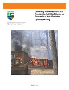
Community Wildfire Protection Plan
An Action Plan for Wildfire Mitigation and Conservation of Natural Resources
Oglethorpe County
MARCH 2016
WILDFIRE PROTECTION PLAN: AN ACTION PLAN FOR WILDFIRE MITIGATION
Prepared by: Leland Bass, Chief Ranger Oglethorpe County Mark Wiles, Specialist Wildfire Prevention & Mitigation
The following report is a collaborative effort between various entities. The representatives listed below comprise the core decision-making team responsible for this report and mutually agree on the plan's contents.
County Representatives: District 1 Commissioner Phil Sanders Signature _________________
District 2 Commissioner Andy Saxon Signature _________________
District 3 Commissioner David R. Clark Signature _________________
District 4 Commissioner John D. Meyer Signature__________________
District 5 Commissioner George Gabriel Signature _________________
Chairman, Board of Commissioners Billy Pittard Signature __________________
Local Fire Department Representatives:
Arnoldsville RFD Chief Mike Eidson Signature _________________
Beaverdam RFD Jason Hamby Signature __________________
Crawford VFD Chief Lynn Shedd Signature _________________
Devils Pond RFD Chief George Gabriel Signature __________________
Glade RFD Chief Walter Trotter Signature _________________
Maxeys RFD Chief Russell Utley Signature __________________
Philomath RFD Chief Nancy Bryan Signature _________________
Pleasant Hill RFD Chief David Huff Signature __________________
Salem RFD Chief Justin Sanders Signature _________________
Sandy Cross RFD Chief Carl Young Signature __________________
Vesta RFD Chief Douglas Spencer Signature _________________
Wolfskin RFD Chief Ed Frey Signature __________________
WILDFIRE PROTECTION PLAN: AN ACTION PLAN FOR WILDFIRE MITIGATION
Wesley Chapel RFD Chief Tommy Paul Signature ___________________
Local USDA Forest Service Representatives:
Tim Kolnik Fire Management Officer Chattahoochee Oconee National Forest Signature _________________________
Local Georgia Forestry Commission Representatives:
Leland Bass Chief Ranger Georgia Forestry Commission Signature ________________________
Brad Bird
Ranger I
Phillip Davis Ranger III
Mark Wiles Community Wildfire Prevention & Mitigation Specialist Georgia Forestry Commission Signature ________________________
WILDFIRE PROTECTION PLAN: AN ACTION PLAN FOR WILDFIRE MITIGATION
PLAN CONTENTS
1. Objectives and Goals 2. County Background and Existing Fire Situation 3. Risk Summary 4. Prioritized Mitigation Recommendations 5. Action Plan, Timetables, and Assessment Strategy 6. County Base and Hazards Maps 7. Appendix
1) OBJECTIVES AND GOALS
The mission of the following report is to set clear priorities for the implementation of wildfire mitigation in Oglethorpe County. The plan includes prioritized recommendations for the appropriate types and methods of fuel reduction and structure ignitability reduction that will protect this county and its essential infrastructure. Prioritized activities to educate the public are included. It also includes a plan for wildfire suppression. Specifically, the plan includes community-centered actions that will:
Educate citizens on wildfire, its risks, and ways to protect lives and properties,
Support fire, rescue, and suppression entities,
Focus on collaborative decision-making and citizen participation,
Develop and implement effective mitigation strategies, and
Develop and implement effective community ordinances and codes.
This plan should become a working document that is shared by local, state, and federal agencies that will use it to accomplish common goals. An agreed-upon schedule for meeting to review accomplishments, solve problems, and plan for the future should extend beyond the scope of this plan. Without this follow up this plan will have limited value
WILDFIRE PROTECTION PLAN: AN ACTION PLAN FOR WILDFIRE MITIGATION
2) COUNTY BACKGROUND AND EXISTING FIRE SITUATION
Oglethorpe County
Oglethorpe County, in northeast Georgia, is the state's seventeenth county and comprises 441 square miles. Creek and Cherokee Indians lived there when the first white people arrived, but they lost their land through treaties signed in 1773. Fur trappers and traders traversed the area before the first nonIndians established permanent settlements. A few trappers established a temporary community known as Kennedy's Gate, but it was no longer extant by the time of the American Revolution (1775-83).
The first permanent white settlers, led by Revolutionary War veteran Colonel George Mathews to Georgia after the war, were a group of wealthy tobacco planters from Virginia. At first the area was all part of Wilkes County, but Oglethorpe County, named for Georgia's founder James Oglethorpe, was carved from Wilkes in 1793 to accommodate population growth. Over the years Oglethorpe County has gained land from surrounding counties, sometimes in exchange for parts of itself.
Towns and Communities
Lexington, the county seat, was first settled in 1774 by a group of North Carolinians who named it in honor of Lexington,
Massachusetts. It was incorporated on November 24, 1806. Oglethorpe County's other incorporated communities are Arnoldsville, Crawford, and Maxeys.
Arnoldsville, settled in the early 1800s by Virginians who established tobacco, cotton,
and silkworm plantations, was not incorporated until 1969. In earlier days the site's
proximity to a Cherokee trail linking Virginia to the Mississippi River made it a popular point for meetings and trading. Colonial governors established a settlement
Oglethorpe County Courthouse
there in the 1770s to regulate Indian trade. The settlement was called Cherokee
Corner until 1894, when a local store owner, Edwin Shaw, became postmaster and renamed the town Edwin, after
himself. Shaw's stores (and postal service rights) were later bought by N. D. Arnold, a wealthy landowner, and the
town adopted his name in 1896. Arnold divided 5,000 acres of his land into small farms and sold them "on liberal
terms" to encourage settlement of the area.
WILDFIRE PROTECTION PLAN: AN ACTION PLAN FOR WILDFIRE MITIGATION
Crawford began as a train stop known as Lexington Depot. Farmers and merchants brought cotton by the wagonload to ship out by train and camped at the depot overnight before going home with goods delivered by the same train. A public well was dug for their convenience, and people later began building permanent dwellings there. Lexington Depot was incorporated in 1876 as Crawford in recognition of U.S. senator William Harris Crawford, who had held the original land grant on which the new settlement emerged. The depot was added to the National Register of Historic Places in 1977.
William H. Crawford
Maxeys, first known as Shanty, then as Salmonville, was named in honor of Jesse Maxey, a
landowner on whose property the town had developed. Maxey had
initially encouraged the railroad to come through the area by giving land for the right of way. However, after the track was completed in 1839, Maxey became concerned about the possible dangers to his family and moved away. The town did not incorporate until 1907. One of Georgia's first commercial fertilizer plants was built there in 1874 by William B. Brightwell. John W. Moody started the state's first commercial scuppernong vineyard, which made thousands of gallons of wine each year from sixty varieties of the fruit, near Maxeys.
Children Picking Cotton
Aside from the incorporated towns, several communities in Oglethorpe County boast interesting histories of their own. Among them is Philomath, in the southernmost part of the county. Settled in the 1830s by Virginians and North Carolinians, the town was originally named Woodstock. It received its current name at the suggestion of Alexander Stephens, who often visited the town's John W. Reed Academy, a boarding school for boys. Philomath's historic district was added to the National Register of Historic Places in 1979.
Smithonia
Letz Feed Mill
(also known as Smithsonia), in the northwestern part of the county, is another historic Oglethorpe County community. Originally called Pleasant Hill, the community began as the thirty-square-mile plantation of James Monroe Smith, an entrepreneur, farmer, gubernatorial candidate, and railroad developer. When the plantation became economically self-sufficient, it acquired a post office and was renamed Smithonia. It was added to the National Register of Historic Places in 1984.
Another community with historic associations is Stephens, built around the Antioch Baptist Church and called Antioch until its name was changed to honor Alexander Stephens. The development of Stephens was spurred by the Georgia Railroad's building of a line through the area in 1839, but in 1925, after a fire destroyed most of its business section and the boll weevil destroyed its cotton crop, the once thriving community lost population.
WILDFIRE PROTECTION PLAN: AN ACTION PLAN FOR WILDFIRE MITIGATION
Economy Soon after the American Revolution, the area now called Oglethorpe County focused on agriculture,
which has remained a mainstay of its economy. The county was first settled by
wealthy planters who set up tobacco plantations; residents later moved into cotton
production with the invention of the cotton gin and the construction of railroads,
which greatly assisted marketing efforts. After the plantation system lost its
profitability in the aftermath of boll weevils, fire, war, and emancipation, the county's
Sunning Wheat
agriculture shifted to small farms, often operated on the sharecropping system. Grain, poultry, beef, and dairy cattle were among the county's major farm products.
Farm income was augmented by employment in the lumber, granite, and textile industries.
Places and People
Points of interest include Bartram Buffalo Lick and Watson Mill Bridge. Bartram Buffalo Lick, near Philomath, was described by naturalist William Bartram in the 1770s and named for its vast pits of kaolin, which were licked first by buffalo and later by cattle, deer, and horses to calm their stomachs. Indians used this location as a reference point and meeting place. Watson Mill Bridge, on the border of Oglethorpe and Madison counties, is the longest original covered bridge in Georgia. Built by W. W. King in 1885, the bridge was restored in 1973.
Kaolin Quarry
Notable residents of Oglethorpe County include author Marion Montgomery and politicians Middleton "Pope" Barrow, William H. Crawford, George R. Gilmer, John Henry Lumpkin, Wilson Lumpkin, and George Mathews.
According to the 2000 U.S. census, the county population was 12,635 (78.3 percent white, 19.8 percent black, and 1.4 percent Hispanic). The population increased 29.4 percent from 1990 to 2000.
The above material courtesy of the New Georgia Encyclopedia
WILDFIRE PROTECTION PLAN: AN ACTION PLAN FOR WILDFIRE MITIGATION
Current Fire Situation:
Wildland fire has not been a serious problem in Oglethorpe County when compared to the rest of the state. Thus far in FY 2016 there have been 8 fires that burned 20.80 acres for an average size of 2.60 acres. During this same period the statewide average was 3.51 acres. The following outlines fire activity in Oglethorpe County for the past 5 complete fiscal years. It should be remembered that the statewide average in FY 2011 was influenced by the Honey Prairie and Race Pond that burned in the Okefenokee area. These large fires caused the statewide average to be greatly increased. Overall, FY 2011 was a year of greatly increased fire activity due to prolonged drought.
Fiscal Year
2015 2014 2013 2012 2011
Number of Fires Acres
13
10.48
26
70.10
29
82.68
29
51.13
48
61.56
Average size
.81 2.70 2.85 1.78 1.28
Statewide average size 4.50 5.02 4.75 4.98 16.16
Thus far in FY 2016, machine use causes have been the most prevalent cause of fire in the county. In 2015, miscellaneous and debris burning fires were represented evenly (8) with incendiary and machine use fires being represented evenly second (2). When looking at the past 5 years however, most causes are fairly evenly distributed. In FY 2011, which was a year of increased fire activity, machine use represented (18 fires) with miscellaneous fires coming in second with (10) fires.
WILDFIRE PROTECTION PLAN: AN ACTION PLAN FOR WILDFIRE MITIGATION
3) Risk Summary
Following a meeting of County officials and representatives of the Georgia Forestry Commission on February 17, 2009 assessments were made of communities at risk within the county. Areas designated for assessment were selected using the Southern Fire Risk Assessment (SFRA) Communities at risk layer supported by local knowledge. It should be noted that not all polygons within the SFRA layer were assessed. The SFRA information was used to assist local fire departments in locating areas that could be assessed. It was not to be the sole deciding factor for determining areas that should be assessed. In all 40 areas were assessed using the Georgia Forestry Commission Form 140 for Woodland Community Wildfire Hazard Assessment. One community was recognized as being at extreme risk, three were designated as at high risk, nineteen were designated at moderate risk, and seventeen were classified as being low. These areas are located primarily in the northwest part of the county. Information on these areas is presented in tabular form in a document entitled `Risk Summary for Areas of Concern Oglethorpe County, Georgia located in the appendix.
WILDFIRE PROTECTION PLAN: AN ACTION PLAN FOR WILDFIRE MITIGATION
4) Prioritized Mitigation Recommendations
The following recommendations were developed during follow-up meetings with County and State fire response agencies. A priority order was determined based on which mitigation projects would best reduce the hazard of wildland fire to communities and infrastructure. The following priorities were considered.
Community Hazard and Structural Ignitability Reduction Wildland Fuel reduction or modification Improvements to capabilities of Wildland response agencies Public Education regarding risk of wildland fire
WILDFIRE PROTECTION PLAN: AN ACTION PLAN FOR WILDFIRE MITIGATION
Proposed Community Hazard and Structural Ignitability Reduction Priorities
Hazard
Lack of defensible space
Access problems for initial attack
Structural Ignitability
Local Codes and Ordinances
Mitigation
Improve defensible space around structures in communities at risk
Improve access problems
Reduce structural ignitability
Improve and amend to codes and ordinances pertaining to infrastructure and community protection from wildland fire.
Method
All departments should examine structures in communities at risk in their response areas. Improvements to defensible space as referenced in Firewise guidelines should be conveyed to residents through media or direct contact. All County response agencies and the Georgia Forestry Commission should closely examine access in all communities identified to be at risk. When problems are identified corrective measures should be made. Citizens in communities at risk should be educated regarding methods to reduce structural ignitability as referenced in Firewise guidelines. This can be accomplished through media or direct contact. Examine all existing codes and ordinances for problems regarding direct conflicts to wildland safety or lack of needed codes or enforcement.
Proposed Wildland Fuel Reduction or modification Priorities
Hazard
Fuel Hazards near Communities at risk
Mitigation Prescribed Burning
Fuel Hazard in public or shared spaces
Fuel Modification or reduction
Method
Determine Communities at risk where Prescribed burning would be appropriate to use. Seek cooperation from adjacent landowners. Find funding to cover cost of burning. Prioritize burn compartments and execute. Determine where hazards exist. Determine appropriate method for modification or reduction. Chipping, raking and piling, County pick-up, Organized Community Clean-up days could be beneficial.
WILDFIRE PROTECTION PLAN: AN ACTION PLAN FOR WILDFIRE MITIGATION
Proposed Improvements to capabilities of Wildland Response Agencies Priorities
Problem or need Lack of qualification or training
Equipment needs
Improvement or
solution Provide training opportunities
Improve or acquire Wildland fire equipment
Details
Examine training records of all wildland responders to insure training and qualifications match expected duties. Insure that all wildland responders have Basic Wildland Certification. Locate and secure funding for enhanced training from state and federal agencies. Determine specific equipment needs to bring all wildland response equipment to NWCG Standards. Provide appropriate PPE to all County wildland responders. Provide wildland hand tools to County departments. Investigate needs for improvements to all wildland water handing and supply (dry hydrants, brush trucks, hose, etc.)
Proposed Public Education Priorities
Educational Priority
Increase public awareness concerning Firewise principles and fire prevention through direct contact Increase public awareness concerning Firewise principles and fire prevention through use of media
Responsible party
County, State, and municipal governments
County, State, and municipal governments
Method
Conduct Firewise meetings by each fire response jurisdiction assisted by Georgia Forestry Commission (state). Conduct a door to door campaign in particularly hazardous communities Use PSA's in local newspapers and local radio stations. Utilize Firewise displays in local post offices and banks. Seek use of local EMC newsletter for Firewise message. Create poster sized notices for use in common public places (stores, post offices, etc. adjacent to high hazard areas advising residents about the hazard and how to protect themselves and their property. Distribute public notices concerning Firewise at local sporting events and other public gatherings. Provide firewise materials to the county building permit office for distribution to developers and individual home builders.
WILDFIRE PROTECTION PLAN: AN ACTION PLAN FOR WILDFIRE MITIGATION
5) Action Plan
GRANT FUNDING AND MITIGATION ASSISTANCE
Georgia Firewise Community Hazard Mitigation Grant: Georgia Forestry Commission grant designed to assist Firewise communities in the mitigation of fire hazards within their community. The grant is designed to provide financial assistance in helping the community to carry out the recommendations of their Firewise Action Plan.
Community Protection Grant: U.S.F.S. sponsored prescribed fire program. Communities with "at-risk" properties that lie within ten miles of a national forest, National Park Service or Bureau of Land Management tracts may apply with the Georgia Forestry Commission to have their land prescribe burned free-of-charge.
FEMA Mitigation Policy MRR-2-08-01: through GEMA Hazard Mitigation Grant Program (HMGP) and Pre-Disaster Mitigation Program (PDM).
1. To provide technical and financial assistance to local governments to assist in the implementation of long term, cost effective hazard mitigation accomplishments.
2. This policy addresses wildfire mitigation for the purpose of reducing the threat to all-risk structures through creating defensible space, structural protection through the application of ignition resistant construction and limited hazardous fuel reduction to protect life and property.
3. With a complete a registered plan (addendum to the State Plan) counties can apply for pre-mitigation funding. They will also be eligible for HMGP funding if the county is declared under a wildfire disaster.
FEMA Assistance to Firefighters Grant Program
1. Assistance to Firefighters Grants (AFG). The purpose of AFG's is to award one-year grants directly to fire departments and emergency medical services (EMS) organizations of a state to enhance their abilities with respect to fire and related hazards.
2. Fire Prevention and Safety Grants. The purpose of these grants is
WILDFIRE PROTECTION PLAN: AN ACTION PLAN FOR WILDFIRE MITIGATION
to assist state, regional, national or local organizations to address fire prevention and safety. Emphasis of the program is on prevention of fire-related injuries to children.
3. Staffing for Adequate Fire and Emergency Response (SAFER). The purpose of SAFER is to award grants directly to volunteer; combination and career fire departments to help the departments increase their cadre of firefighters (enhance their ability for 24-hour response).
Georgia Forestry Commission: Plowing and prescribed burning assistance, as well as forest mastication can be obtained from the GFC as a low-cost option for mitigation efforts.
Individual Homeowners:
1. The elimination of hazardous conditions around a structure must ultimately be the responsibility of the community and the homeowner. They will bear the cost and reap the benefit from properly implemented mitigation efforts.
2. GEMA: Pre-Disaster Mitigation Grant Program
WILDFIRE PROTECTION PLAN: AN ACTION PLAN FOR WILDFIRE MITIGATION
5) Action Plan Continued
Steps to implement Community Hazard and Structural Ignitability Priorities
Hazard
Lack of Defensible Space
Access problems
Structural Ignitability
Codes and Ordinances
Specific Action and Responsible Party
Using the risk summary in section 3, each department should conduct inspections of communities at risk in their jurisdiction or area of response for lack of defensible space. Findings will be conveyed to residents and treatment methods will be recommended in accordance with Firewise principles. Using the County Base map the Georgia Forestry Commission and Oglethorpe County Fire officials should visit all identified communities at risk for the purpose of locating and resolving access difficulties. This inspection should extend into the wildland adjacent to the communities at risk looking for hindrances to suppression tactics Oglethorpe County Fire officials should examine structures for structural ignitability concerns at the time when the communities at risk are inspected for lack of defensible space. Using Firewise guidelines for reducing structural ignitability,( a checklist from the Firewise web site could be used) structures should be assessed and findings conveyed to residents. This could be through use of media or by direct contact. Oglethorpe County and municipal Fire Marshalls should closely examine all codes and ordinances for gaps and oversights which could cause problems in the wildland fire arena. Examples include proximity of propane tanks to structures, accumulations of debris, Road widths in proposed developments, lack of proper identification pertaining address or street names etc..
Steps to Implement Fuel Reduction or Modification Priorities
Hazard
Hazardous Wildland Fuel Accumulations
Hazardous Fuel Accumulations in communities and hindrances to suppression
Specific Action and Responsible Party
The Georgia Forestry Commission will prioritize prescribed burning projects adjacent to Communities at risk where burning is determined to be appropriate. The communities of Maxeys and Stephens should be considered. In any communities where burning is opposed or not practical, permanent or semi-permanent firebreaks could be installed. These breaks should be mapped and their location(s) made known to all responding agencies. Citizens should be educated as to their purpose. Using the risk summary in section 3, Fire departments could conduct community clean up days in communities at risk in their respective jurisdictions aimed at reducing hazardous fuels and hindrances to suppression in shared community space. Residents would be provided with guidance and access to disposal alternatives for materials removed. Organized burning support in a common area on a specific day could be considered along with the use of a chipper whereby residents could mulch debris as opposed to burning.
WILDFIRE PROTECTION PLAN: AN ACTION PLAN FOR WILDFIRE MITIGATION
5) Action Plan Continued
Steps to implement improvements to wildland response capability
Improvement needed
Improve training and qualification of Oglethorpe County Wildland firefighters
Improve or acquire wildland firefighting equipment
Responsible Party and specific action
Chief Ranger Leland Bass, Assistant District Manager David Epps of the Georgia Forestry Commission and Oglethorpe Co Fire Chief Russell Utley should examine all training records for personnel under their supervision. All personnel should be certified Georgia Basic Wildland Firefighters or higher in qualification. Additional training and qualification should be sought for personnel identified in Oglethorpe County who are assigned specific Incident Command System (ICS) functions. Sources for available funds for training should be sought at State and Federal levels. All stations for Oglethorpe County Fire Departments should inventory their present equipment relating to their wildland capability. Funding sources should be investigated from available grants or other sources. Needs for job specific wildland responses should be examined by Chief Ranger Bass and individual Fire Chiefs for each station.
Steps to educate or inform the Public regarding wildland fire prevention and responsibilities
Opportunity
Improve Public Education through direct contact
Improve Public Education through use of media
Responsible Party and Specific Action
Prior to the onset of fire season(s) rangers of the Georgia Forestry Commission and Oglethorpe County Fire personnel should conduct Firewise meetings in conjunction with normally scheduled fire department meetings. People living in or near extreme and high risk communities should be invited to these meetings by use of door to door campaigns or by mailbox flyers. Notices regarding these meetings could be placed in local post offices or stores near communities at risk. A Firewise display should be acquired and utilized at this meeting. This display would be retained by the Oglethorpe office of the Georgia Forestry Commission and used for all Firewise meetings in Oglethorpe County. Local news media should be invited to these meetings. Goals for potential Firewise certified communities in Oglethorpe County could be considered after these meetings are completed. Prior to the onset of fire season(s) or during periods of particularly high fire danger use of the media should be stepped up by personnel of the Georgia Forestry Commission. This should include use of all available media in the County. PSA's should be run weekly during periods of high to extreme fire danger. Signs or poster boards could be developed for display in public spaces near communities at risk advising residents that they live in areas that are susceptible to wildland fire and directing them to sources of information regarding wildland fire safety.
WILDFIRE PROTECTION PLAN: AN ACTION PLAN FOR WILDFIRE MITIGATION
Timetables for Actions
Steps to implement Community Hazard and Structural Ignitability Priorities
Steps to examine communities at risk for defensible space and structural ignitability should begin as soon as practical with existing work schedules. This should occur prior to the time when most citizens begin fall or spring cleanup projects in order for recommendations regarding improvements to defensible space and reduction of structural ignitability to coincide with these seasonal actions.
Pre-planning to examine access and suppression problems should take place as soon as possible by fire department jurisdiction.
Codes and Ordinances should be examined as soon as possible.
Steps to implement Fuel Reduction or Modification Priorities
The prescribed burn project to reduce fuels near the Maxeys and Stephens
Communities has become part of the US Forest Service project for reducing heavy fuel accumulations, as well as to enhance wildlife habitat on the Oconee National Forest. Any other priority burn projects or installation of pre suppression fuel breaks should take place after leaf fall each autumn.
Steps are being taken reduce fuels in communities at risk. Those steps coincide
with steps to improve defensible space and reduce structural ignitability The City of Maxeys is now classified as a Firewise Community, and has received grant funding to help mitigate the risk in that community. The Salem Community has also recently become a Firewise community, and is working to mitigate the risk in their community.
Steps to implement improvements to wildland response capability
Cooperation between state and local wildland suppression forces regarding
improvements to training and equipment should begin immediately.
Steps to educate or inform the Public regarding wildland fire prevention and responsibilities
WILDFIRE PROTECTION PLAN: AN ACTION PLAN FOR WILDFIRE MITIGATION
Direct contact with residents in Communities at risk should take place as soon as possible.
The use of media should coincide with the above action.
WILDFIRE PROTECTION PLAN: AN ACTION PLAN FOR WILDFIRE MITIGATION
Assessment of Actions
Reduction of Community hazard and structural ignitability
Direct measurement of the number of communities assessed would be the appropriate measure of success
Any meetings that result in cooperation between wildland departments should be logged along with minutes of those meetings. Goals should be set and reviewed after each meeting.
Any changes to or additions to codes and ordinances would be an obvious measure of success.
Steps to implement Fuel Reduction or Modification Priorities
Acres burned would be the appropriate measure for fuel reduction. A direct measure of linear feet of firebreaks would be an appropriate measure for pre suppression breaks.
Fuel reduction in communities at risk would be measured by the number of communities affected and number of projects completed.
Steps to implement improvements to wildland response capability
A direct measure of the number of capabilities or qualifications gained would be the appropriate measure of success.
Any equipment acquired or any equipment brought up to national standards would be the appropriate measure of success.
Steps to educate or inform the Public regarding wildland fire prevention and responsibilities
Direct measurement of the number of persons contacted, literature distributed, public notices posted, news articles published, radio programs aired, etc. would be the best measure of success.
Continue to promote the Firewise Program in the county. Encourage these communities to embrace the program, especially those communities that lie within the high risk areas of the county.
WILDFIRE PROTECTION PLAN: AN ACTION PLAN FOR WILDFIRE MITIGATION
7) County Base and Hazards Maps
WILDFIRE PROTECTION PLAN: AN ACTION PLAN FOR WILDFIRE MITIGATION
WILDFIRE PROTECTION PLAN: AN ACTION PLAN FOR WILDFIRE MITIGATION
WILDFIRE PROTECTION PLAN: AN ACTION PLAN FOR WILDFIRE MITIGATION
WILDFIRE PROTECTION PLAN: AN ACTION PLAN FOR WILDFIRE MITIGATION
WILDFIRE PROTECTION PLAN: AN ACTION PLAN FOR WILDFIRE MITIGATION
8) Appendix
Risk Summary table
All files that make up this plan are available in an electronic format from the Georgia Forestry Commission. This is especially useful in regard to viewing the PDF files that make up the County Base and Hazards maps in that it will allow for increased magnification and better resolution.
WILDFIRE PROTECTION PLAN: AN ACTION PLAN FOR WILDFIRE MITIGATION
P. O. Box 819 Macon, GA 31202 1-800-GA-TREES GaTrees.org
The Georgia Forestry Commission provides leadership, service, and education in the protection and conservation of Georgia's forest resources. An Equal Opportunity Employer and Service Provider