- Collection:
- Georgia Government Publications
- Title:
- Community wildfire protection plan, Crawford County: an action plan for wildfire mitigation and conservation of natural resources
- Creator:
- Georgia. Forestry Commission
- Publisher:
- Macon, Ga. : Georgia. Forestry Commission
- Date of Original:
- 2016
- Subject:
- Wildfires--Georgia--Crawford County--Prevention and control
Fire management--Georgia--Crawford County
Chorochromatic maps
Circular graphs
Bar graphs
Transportation maps - Location:
- United States, Georgia, 32.75042, -83.50018
United States, Georgia, Crawford County, 32.7145, -83.98634 - Medium:
- plans (reports)
- Type:
- Text
- Format:
- application/pdf
- External Identifiers:
- OCLC 1164700625
NZ MMS ID 9922026255802931
Call Number F600 .M1 2016 W5 C7 - Metadata URL:
- https://dlg.galileo.usg.edu/id:dlg_ggpd_s-ga-bf600-b-pm1-b2016-bw5-bc7-belec-p-btext
- Digital Object URL:
- https://dlg.galileo.usg.edu/do:dlg_ggpd_s-ga-bf600-b-pm1-b2016-bw5-bc7-belec-p-btext
- Language:
- eng
- Holding Institution:
- University of Georgia. Map and Government Information Library
- Rights:
-

_________________________
_A Program of the Georgia Forestry Commission
with support from the U.S. Forest Service
Community Wildfire Protection Plan
An Action Plan for Wildfire Mitigation and Conservation of Natural Resources
Crawford County, Georgia
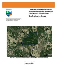
Aerial map of a prescribed burn project adjacent to Carl Sutton Road and Sarah Hill Community
September 2016
WILDFIRE PROTECTION PLAN: AN ACTION PLAN FOR WILDFIRE MITIGATION
The following report is a collaborative effort between various entities. The representatives listed below comprise the core decision-making team responsible for this report and mutually agree on the plan's contents. Community Representatives: District 1 Sterling Braswell Signature _______________________________ District 2 - Bobby Blasingame, Vice Chairman Signature _______________________________ District 3 Justin Spillers Signature _______________________________ District 4 John Thomas Signature _______________________________ District 5 Paul Chapman, Chairman Signature _______________________________ County Fire Department Representatives: Randy Pate - Fire Chief, Crawford County Fire Department Signature _______________________________ Rick Sharon, Director, Crawford County Emergency Management Signature _______________________________ Georgia Forestry Commission Representatives: Nick Tresco, Chief Ranger, Crawford County Signature _______________________________ Beryl Budd, Wildfire Prevention Specialist Signature _______________________________
2
WILDFIRE PROTECTION PLAN: AN ACTION PLAN FOR WILDFIRE MITIGATION
PLAN CONTENTS
PAGE
I. Objectives & Community Collaboration .................................................................. 4 II. Community Background and Wildfire History .......................................................... 5 III. Community Base Maps ........................................................................................ 11 IV. Community Wildfire Risk Assessment.................................................................. 14 V. Southern Wildfire Risk Assessment(SouthWRAP) & Risk Hazards Maps............ 19 VI. Prioritized Mitigation Recommendations ............................................................. 23 VII. Action Plan ........................................................................................................... 25 VIII. Grant Funding & Mitigation Assistance ................................................................. 29 IX. Glossary ................................................................................................................ 30 X. Sources of Information............................................................................ 32
Appended Documents: Crawford County Southern Wildfire Risk Assessment Summary Report (SouthWRAP)
3
WILDFIRE PROTECTION PLAN: AN ACTION PLAN FOR WILDFIRE MITIGATION
I.) OBJECTIVES AND COMMUNITY COLLABRATION
A Community Wildfire Protection Plan (CWPP) provides a community with a road map to reduce its risk from wildfire. A CWPP is designed through collaboration between state and local fire agencies, homeowners and landowners, and other interested parties such as city councils, utilities, home owner associations, environmental organizations, and other local stakeholders.
The plan identifies strategic sites and methods for risk reduction and structural protection projects across jurisdictional boundaries.
Comprehensive plans provide long-term guidance for growth, reflecting a community's values and future expectations. The plan implements the community's values and serves to protect natural and community resources and public safety. Planning also enables communities to address their development patterns in the Wildland Urban Interface and determine how they can reduce their risk through alternative development patterns. The formal legal standing of the plan and its central role in local government decision making underscores the opportunity to use this planning process as an effective means for reducing wildfire risk.
The mission of the following plan is to set clear priorities for the implementation of wildfire mitigation in Crawford County. The plan includes prioritized recommendations for the appropriate types and methods of fuel reduction and structure ignitability reduction that will help protect this community and its essential infrastructure. It also includes a plan for wildfire suppression. Specifically, the plan includes communitycentered actions that will:
Educate citizens about wildfire, its risks, and ways to protect lives and properties.
Support fire rescue and suppression entities.
Focus on collaborative decision-making and citizen participation.
Develop and implement effective mitigation strategies.
Develop and implement effective community ordinances and codes.
This plan should become a working document that is shared by local, state, and federal agencies that will use it to accomplish common goals. An agreed-upon schedule for meeting to review accomplishments, solve problems, and plan for the future should extend beyond the scope of this plan. Without this follow up this plan will have limited value.
4
WILDFIRE PROTECTION PLAN: AN ACTION PLAN FOR WILDFIRE MITIGATION
II.) COUNTY BACKGROUND AND WILDFIRE HISTORY
Crawford County History
Crawford County, in west central Georgia, is Georgia's fifty-seventh county. The 325square-mile county was created on December 9, 1822, from Houston County, which had been formed from land given up by the Creek Indians in the 1821 Treaty of Indian Springs. The county is named for statesman William Harris Crawford, who had served as a U.S. senator, minister to France, and secretary of the treasury. The first white settlers in the area were Indian agent Benjamin Hawkins and his family. Arriving in 1803, they built a five-
square-mile compound on the Flint River. The compound included a shop and plantation, which became known as the Creek Agency Reserve. Although Hawkins was well liked by the Creeks, he believed, as did many white men of his time,
that the Indians should embrace a European-American way of life. His efforts to persuade the Creeks, however, were largely
Hawkins Monument
unsuccessful. Hawkins died at the reserve in 1816.
Knoxville was established on the Federal Road, the main stagecoach and telegraph
route from Washington, D.C., to New Orleans, making the town a natural choice for
county seat. Although the chief center of population is now Roberta, a mile to its west,
Knoxville (no longer an incorporated city) retains its designation as
the county seat. The current courthouse, built there in 2002,
replaced one built in 1851, which still stands.
Roberta, originally called New Knoxville, is the only incorporated
city in the county. It was incorporated on December 26, 1890.
Roberta started out in 1886 as a railroad
office and warehouse at the Southern
Roberta, ca 1900
Railroad Company's "89 Fort Valley" milepost. Two years later, after a freight
depot and passenger station were completed at the site,
people began to settle in the immediate area. Townspeople
gave the honor of naming the new town to Hiram McCrary,
who had given the railroad the rights to come through his land.
McCrary chose to call it Roberta in honor of his young
Crawford County Courthouse
daughter. Most of the inhabitants of Knoxville, a mile away,
moved to Roberta when the railroad arrived. For years, while passenger train service
5
WILDFIRE PROTECTION PLAN: AN ACTION PLAN FOR WILDFIRE MITIGATION
was an important mode of transportation, Roberta served as a thriving tourist stop on the route to Florida. After passenger train service gave way to the private automobile the city relaxed into a quiet residential town. Other communities in the county are Gaillard, Horns, Lee Pope, Musella, and Zenith. During the county's early days, settlers relied first on agriculture and then on cattle ranching, timber harvesting, and sand extraction as economic mainstays. Agriculture continues to be important, as are manufacturing and health and social services. Many residents also work in neighboring areas, especially Bibb County. Well-known figures from Crawford County include Jefferson Franklin Long, Georgia's first African American congressional representative and the first African American to speak from the floor of the U.S. House of Representatives. Long, of mixed African and Caucasian ancestry, was born into slavery Jefferson Franklin Long in Knoxville. As a freedman after the Civil War (1861-65), he became a tailor, but an avid interest in equal rights led him to politics. He was elected to Congress in December 1870 and served until March 1871. John Stith Pemberton, the inventor of Coca-Cola, was also born in Knoxville. Pemberton was a veteran Confederate lieutenant colonel who served on the first Georgia pharmacy licensing board after the war. His state-of-the-art laboratory for chemical analysis and manufacturing became the first state-run facility to conduct tests of soil and crop chemicals. Joanna E.Troutman, who designed the first Lone Star flag (later adopted as a major Texas emblem), was born in Crawford County. She presented her flag to the Georgia Battalion, who went to Texas in 1835 to assist Texans in their fight for independence. Although Troutman lived most of her life in Knoxville, her remains were moved to the Texas state cemetery in Austin, where a bronze statue was erected in her honor. A portrait of Troutman also hangs in the Texas State Capitol. Among places of interest in Knoxville are the Old Jail Museum and the Old Courthouse, which was built in 1851 and houses documents and local history. The Museum of Southeastern Indians, with its collection of Indian artifacts and Appalachian settler history, is in Roberta. According to the 2010 U.S. census, the county population is 12,630, a slight increase from the 2000 population of 12,495.
6
WILDFIRE PROTECTION PLAN: AN ACTION PLAN FOR WILDFIRE MITIGATION
Wildfire History
During the 2016 fiscal year (July 2015 June 2016) there were 47 wildfires that burned over 208 acres. Incendiary (arson) fires (22) was the leading cause of these wildfires.
County = Crawford
Cause
Fires
Acres
Fires 5 Yr Avg
Acres 5 Yr Avg
Campfire
Campfire
0
0.00 3.00 5.07
Children
Children
3
0.78 3.20 4.24
Debris: Ag Fields, Pastures, Orchards, Etc
Debris: Ag Fields, Pastures, Orchards, Etc
0
0.00 1.40 24.75
Debris: Escaped Prescribed Burn Debris: Escaped Prescribed Burn
1
2.08 3.20 49.72
Debris: Other
Debris: Other
0
0.00 1.00 3.48
Debris: Residential, Leafpiles, Yard, Etc
Debris: Residential, Leafpiles, Yard, Etc
1
9.48 3.80 15.43
Debris: Site Prep - Forestry Related Debris: Site Prep - Forestry Related
1
18.31 3.00 29.16
Incendiary
Incendiary
22
69.10 6.00 26.01
Lightning
Lightning
3
75.06 2.20 21.81
Machine Use
Machine Use
8
27.74 6.40 10.53
Miscellaneous
Miscellaneous: Cutting/Welding/Grinding
Miscellaneous: Firearms/Ammunition
Miscellaneous
Miscellaneous: Cutting/Welding/Grinding
Miscellaneous: Firearms/Ammunition
0
0.00 0.20 0.47
0
0.00 0.20 0.55
0
0.00 0.20 0.19
Miscellaneous: Other
Miscellaneous: Other
2
1.25 1.60 1.76
Miscellaneous: Power lines/Electric Miscellaneous: Power lines/Electric
fences
fences
1
Miscellaneous: Spontaneous Heating/Combustion
Miscellaneous: Spontaneous Heating/Combustion
0
Miscellaneous: Structure/Vehicle Fires
Miscellaneous: Structure/Vehicle Fires
2
Miscellaneous: Woodstove Ashes Miscellaneous: Woodstove Ashes
1
Undetermined
Undetermined
2
0.20 1.40 2.88 0.00 0.20 0.98 0.30 2.60 1.90 0.28 1.20 0.91 4.25 2.60 7.78
Crawford Totals for 2016
47
208.83 43.40 207.62
7
WILDFIRE PROTECTION PLAN: AN ACTION PLAN FOR WILDFIRE MITIGATION The graphs below indicate the number of wildfires and acreage burned FY2005-2015. During these years the annual average was 52 wildfires burning about 220 acres each year.
8
WILDFIRE PROTECTION PLAN: AN ACTION PLAN FOR WILDFIRE MITIGATION
The following table outlines Crawford County wildfire activity for fiscal years 2005 through 2015 in comparison to the statewide average. It should be remembered that the average size fire and fire activity was greatly increased in fiscal year 2007 and 2011due to drought conditions and the large fires that occurred in the Okefenokee National Refuge area and SE Ga. These were record high years for wildfire activity and acreage burned. It should also be noted that fiscal year 2010 and 2015 were record low years for wildfire activity in Georgia due to extremely wet conditions.
Fiscal Year 2015 2014 2013 2012 2011 2010 2009 2008 2007 2006
Number of Fires 47 49 49 25 83 37 47 49 69 66
Acres 173.18 154.19 213.90 288.0 399.20 440.94 68.63 357.36 133.28 414.75
Average size 3.69 3.15 4.37 11.52 4.81 11.92 1.46 7.29 1.93 6.28
Statewide Average size 1.95 3.07 3.28 3.98 22.90 1.86 3.90 4.56 18.64 3.93
9
WILDFIRE PROTECTION PLAN: AN ACTION PLAN FOR WILDFIRE MITIGATION
The primary cause of wildfires in Crawford County, for the 10 year period indicated on the pie chart on the previous page and the table below, has been careless debris burning (41%). Typically this is the primary cause, accounting for about 50% of wildfires throughout Georgia. The second leading cause in the County is equipment use (21%). Since 2015 there has been a huge increase in incendiary (arson) fires accounting for over half of the wildfire activity in the County during FY 2015 and 2016.
Number of Fires by Cause for Crawford County 2005 to 2015
Year Campfire Children
Debris Burning
Incendiary
Lightning
Machine Use
Miscellaneous Railroad Smoking
2005
5
4
21
6
1
16
7
0
1
2006
1
0
26
13
3
17
5
0
1
2007
1
1
22
3
5
14
3
0
2
2008
1
3
26
5
2
15
5
0
1
2009
1
2
18
3
1
6
5
0
0
2010
2
1
31
3
1
9
9
0
1
2011
2
3
29
1
9
16
4
0
0
2012
6
3
18
1
5
2
5
0
0
2013
3
4
17
0
0
7
15
0
0
2014
3
3
16
1
1
8
20
0
0
2015
2
5
3
26
3
7
3
0
0
10
WILDFIRE PROTECTION PLAN: AN ACTION PLAN FOR WILDFIRE MITIGATION
III.) Community Base Maps
11
WILDFIRE PROTECTION PLAN: AN ACTION PLAN FOR WILDFIRE MITIGATION 12
WILDFIRE PROTECTION PLAN: AN ACTION PLAN FOR WILDFIRE MITIGATION 13
WILDFIRE PROTECTION PLAN: AN ACTION PLAN FOR WILDFIRE MITIGATION
IV.) Community Wildfire Risk Assessment
The Wildland-Urban Interface
There are many definitions of the Wildland-Urban Interface (WUI), however from a fire management perspective it is commonly defined as an area where structures and other human development meet or intermingles with undeveloped wildland or vegetative fuels. As fire is dependent on a certain set of conditions, the National Wildfire Coordinating Group has defined the wildland-urban interface as a set of conditions that exists in or near areas of wildland fuels, regardless of ownership. This set of conditions includes type of vegetation, building construction, accessibility, lot size, topography and other factors such as weather and humidity. When these conditions are present in certain combinations, they make some communities more vulnerable to wildfire damage than others. This "set of conditions" method is perhaps the best way to define wildlandurban interface areas when planning for wildfire prevention, mitigation, and protection activities.
There are three major categories of wildland-urban interface. Depending on the set of conditions present, any of these areas may be at risk from wildfire. A wildfire risk assessment can determine the level of risk.
1. "Boundary" wildland-urban interface is characterized by areas of development where homes, especially new subdivisions, press against public and private wildlands, such as private or commercial forest land or public forests or parks. This is the classic type of wildland-urban interface, with a clearly defined boundary between the suburban fringe and the rural countryside.
2. "Intermix" wildland-urban interface areas are places where improved property and/or structures are scattered and interspersed in wildland areas. These may be isolated rural homes or an area that is just beginning to go through the transition from rural to urban land use.
3. "Island" wildland-urban interface, also called occluded interface, are areas of wildland within predominately urban or suburban areas. As cities or subdivisions grow, islands of undeveloped land may remain, creating remnant forests. Sometimes these remnants exist as parks, or as land that cannot be developed due to site limitations, such as wetlands.
14
WILDFIRE PROTECTION PLAN: AN ACTION PLAN FOR WILDFIRE MITIGATION
The Wildland Urban Interface (WUI) reflects housing density depicting where humans and their structures meet or intermix with wildland fuels.
Wildland Urban Interface Hazards Firefighters in the wildland urban interface may encounter hazards other than the fire itself, such as hazardous materials, utility lines and poor access.
Hazardous Materials Common chemicals used around the home may be a direct hazard to firefighters from flammability, explosion potential and/or vapors or offgassing. Such chemicals include paint, varnish and other flammable liquids; fertilizer; pesticides; cleansers; aerosol cans, fireworks, batteries and ammunition. In addition, some common household products such as plastics may give off very toxic fumes when they burn. Stay OUT of the smoke from burning structures and any unknown sources such as trash piles.
Illicit Activities Marijuana plantations or drug production labs may be found in wildland urban interface areas. Extremely hazardous materials such as propane tanks and flammable/toxic chemicals may be encountered, as well as booby traps.
Propane tanks Both large (household size) and small (gas grill size) liquefied propane gas (LPG) tanks can present hazards to firefighters, including explosion. See the "LPG Tank Hazards" discussion for details.
15
WILDFIRE PROTECTION PLAN: AN ACTION PLAN FOR WILDFIRE MITIGATION
Utility lines Utility lines may be located above and below ground and may be cut or damaged by tools or equipment. Don't spray water on utility lines or boxes.
Septic tanks and fields Below-ground structures may not be readily apparent and may not support the weight of engines or other apparatus.
New construction materials Many new construction materials have comparatively low melting points and may "off-gas" extremely hazardous vapors. Plastic decking materials that resemble wood are becoming more common and may begin softening and losing structural strength at 180 F, though they normally do not sustain combustion once direct flame is removed. However, if they continue to burn they exhibit the characteristics of flammable liquids.
Pets and livestock Pets and livestock may be left when residents evacuate and will likely be highly stressed, making them more inclined to bite and kick. Firefighters should not put themselves at risk to rescue pets or livestock.
Evacuation occurring Firefighters may be taking structural protection actions while evacuations of residents are occurring. Be very cautious of people driving erratically. Distraught residents may refuse to leave their property, and firefighters may need to disengage from fighting fire to contact law enforcement officers for assistance. In most jurisdictions firefighters do not have the authority to force evacuations. Firefighters should not put themselves at risk trying to protect someone who will not evacuate!
Limited access Narrow one-lane roads with no turn-around room, inadequate or poorly maintained bridges and culverts are frequently found in wildland urban interface areas. Access should be sized-up and an evacuation plan for all emergency personnel should be developed.
16
WILDFIRE PROTECTION PLAN: AN ACTION PLAN FOR WILDFIRE MITIGATION
Crawford County Assessments
Following an initial meeting on May 6, 2009 with Georgia Forestry Commission personnel and Rick Sharon with Central Georgia Technical College, assessments were made of communities at risk in the county. The assessments were made using Georgia Forestry Commission form 140 for Woodland Community Wildfire Hazard Assessment. This form ranks woodland communities or interface areas based on a numerical score. Subdivision design, site hazard, building construction and additional factors are rated to provide an overall rating. Communities are rated as being at extreme, high, moderate, or at low risk. In all, twenty eight (28) communities were assessed. There was one (1) rated as high risk, nineteen (19) moderate, and eight (8) rated low risk. The spreadsheet is located below and the original copies of the assessments are retained by the Crawford County Unit of the Georgia Forestry Commission.
Community Name or Location
Latitude Longitude # ofHomes Hazard Rating Risk Category Jurisdiction
Schofill , Oakwood, and Eastwood Rds
83 53.531' 32 40.041'
67
133
High
Station 6
Oak Hill Dr. off Jordan Rd.
83 48.557' 32 40.648'
18
116
Moderate
Station 6
Childers (Hwy 128 2 miles SW Roberta)
84 2.051' 32 42.520'
30
114
Moderate
July Drive and Victory Ln.
84 3.257' 32 41.688'
5
109
Moderate
Station 5
Quail Run (Jackson and Mathews Rd)
83 57.351' 32 41.864'
21
108
Moderate
Station 1
Spring Valley Dr. Off Jordon Rd
83 48.487' 32 40.877'
26
107
Moderate
Station 6
Juniper Creek Rd Autumn Rd Emerald Way 83 47.461' 32 40.667'
51
106
Moderate
Station 6
Jack Brown Estates
83 46.635' 32 41.937'
50
104
Moderate
Station 6
Hwy 80 East and Spring Hill Church Rd
83 55.425' 32 47.051'
29
103
Moderate
Station 8
Hartley Bridge Rd and Field Dr.
83 48.554' 32 42.331'
13
101
Moderate
Station 6
Whitaker Rd and Charlie Reeves Rd
84 9.200' 32 43.801'
9
100
Moderate
Station 2
Moncrief Rd
-84 2.463' 32 42.126'
30
93
Moderate
Station 5
Delone Rd Candice Dr.
83 50.799' 32 43.325'
54
91
Moderate
Station 3
Chapman Rd
83 50.702' 32 44.975'
55
90
Moderate
Station 3
Bluebird Lane
84 0.272' 32 40.570'
4
89
Moderate
Station 1
Cedar Point
83 46.257' 32 41.982'
33
86
Moderate
Station 6
Creekview
83 50.998' 32 45.957'
27
85
Moderate
Station 3
Carl Sutton Rd / Sarah Hill Circle
83 52.166' 32 44.836'
32
80
Moderate
Station 3
Cactus Hill Rd
84 0.558' 32 41.084'
14
78
Moderate
Station 1
Bobby Circle Lower Hartley Bridge Rd.
83 49.349' 32 42.257'
40
76
Moderate
Station 6
Winchester Estates
83 46.301' 32 41.545'
33
74
Low
Station 6
Hwy 341 North (Roberta)
84 1.026' 32 43.723'
38
74
Low
Station 1
Pine Forest Dr.
84 2.067' 32 48.161'
12
73
Low
Station 4
Pine Tree Estates
84 3.845' 32 41.539'
17
72
Low
Station 5
Mathews Dr. (Roberta)
84 0.576' 32 42.822'
22
68
Low
Station 1
Hwy 128 Walker Chapel Rd Stuart Ln.
84 3.163' 32 41.867'
2
55
Low
Station 5
Hatcher Rd Knoxville
84 1.790' 32 47.903'
5
54
Low
Station 4
83 59.803' 32 43.467'
9
40
Low
Station 1
17
WILDFIRE PROTECTION PLAN: AN ACTION PLAN FOR WILDFIRE MITIGATION
Pictured here are examples of areas where prescribed burns are conducted to minimize risk near developed areas. Pictured above is an aerial map of the burn project near Bobbie Circle community and below is a project near Schofill Rd. community.
18
WILDFIRE PROTECTION PLAN: AN ACTION PLAN FOR WILDFIRE MITIGATION
V.) Southern Wildfire Risk Assessment & Risk Hazard Maps
The Southern Wildfire Risk Assessment tool, developed by the Southern Group of State Foresters, was released to the public in July 2014. This tool allows users of the Professional Viewer application of the Southern Wildfire Risk Assessment (SWRA) web Portal (SouthWRAP) to define a specific project area and summarize wildfire related information for this area. A detailed risk summary report is generated using a set of predefined map products developed by the Southern Wildfire Risk Assessment project which have been summarized explicitly for the user defined project area. A risk assessment summary was generated for Crawford County. The SouthWRAP (SWRA) products included in this report are designed to provide the information needed to support the following key priorities:
Identify areas that are most prone to wildfire
Identify areas that may require additional tactical planning, specifically related to mitigation projects and Community Wildfire Protection Planning
Provide the information necessary to justify resource, budget and funding requests
Allow agencies to work together to better define priorities and improve emergency response, particularly across jurisdictional boundaries
Define wildland communities and identify the risk to those communities
Increase communication and outreach with local residents and the public to create awareness and address community priorities and needs
Plan for response and suppression resource needs
Plan
and
prioritize
hazardous fuel treatment
programs
Wildland Urban Interface map from the Crawford County SouthWRAP report
19
WILDFIRE PROTECTION PLAN: AN ACTION PLAN FOR WILDFIRE MITIGATION
Wildland Urban Interface Risk (above) and WUI Risk acreage graph (below)
20
WILDFIRE PROTECTION PLAN: AN ACTION PLAN FOR WILDFIRE MITIGATION
Community Protection map identifies where populated areas are located (above) and flame length map (below) identifies areas where a wildfire could potentially be extremely difficult to control.
21
WILDFIRE PROTECTION PLAN: AN ACTION PLAN FOR WILDFIRE MITIGATION
Fire Intensity Scale map (above) identifies areas where wildfire potentially will burn with greater intensity and the fire intensity graph (below) indicates the number of acres in each intensity level.
22
WILDFIRE PROTECTION PLAN: AN ACTION PLAN FOR WILDFIRE MITIGATION
VI.) Prioritized Mitigation Recommendations
The following recommendations were developed during follow-up meetings with County and State fire response agencies. A priority order was determined based on which mitigation projects would best reduce the hazard of wildland fire to communities and infrastructure. The following priorities were considered.
Community Hazard and Structural Ignitability Reduction Wildland Fuel reduction or modification Improvements to capabilities of Wildland response agencies Public Education regarding risk of wildland fire
Proposed Community Hazard and Structural Ignitability Reduction Priorities
Hazard
Lack of defensible space
Access problems for initial attack
Structural Ignitability
Local Codes and Ordinances
Mitigation
Improve defensible space around structures in communities at risk
Improve access problems
Reduce structural ignitability
Improve and amend to codes and ordinances pertaining to infrastructure and community protection from wildland fire.
Method
All departments should examine structures in communities at risk in their response areas. Improvements to defensible space as referenced in firewise guidelines should be conveyed to residents through media or direct contact. All County response agencies and the Georgia Forestry Commission should closely examine access in all communities identified to be at risk. When problems are identified corrective measures should be made. Citizens in communities at risk should be educated regarding methods to reduce structural ignitability as referenced in firewise guidelines. This can be accomplished through media or direct contact. Examine all existing codes and ordinances for problems regarding direct conflicts to wildland safety or lack of needed codes or enforcement. In 2014 Georgia adopted the International Wildland Urban Interface Code (IWUIC)
23
WILDFIRE PROTECTION PLAN: AN ACTION PLAN FOR WILDFIRE MITIGATION
Proposed Wildland Fuel Reduction or modification Priorities
Hazard Fuel Hazards near Communities at risk
Fuel Hazard in public or shared spaces
Mitigation Prescribed Burning and permanent firebreaks
Fuel Modification or reduction
Method Determine Communities at risk where Prescribed burning would be appropriate to use. Seek cooperation from adjacent landowners. Find funding to cover cost of burning. Prioritize burn compartments and execute. Install permanent breaks where desired or practical. Determine where hazards exist. Determine appropriate method for modification or reduction. Chipping, raking and piling, mastication, County pick-up, Organized Community Clean-up days could be beneficial.
Proposed Improvements to capabilities of Wildland Response Agencies Priorities
Problem or need
Lack of qualification or training
Improvement or
solution Provide training opportunities
Equipment needs
Improve or acquire Wildland fire equipment
Details
Examine training records of all wildland responders to insure training and qualifications match expected duties. Insure that all wildland responders have Basic Wildland Certification. Locate and secure funding for enhanced training from state and federal agencies. Determine specific equipment needs to bring all wildland response equipment to NWCG Standards. Provide appropriate PPE to all County wildland responders. Provide wildland hand tools to County departments. Investigate needs for improvements to all wildland water handing and supply (dry hydrants, brush trucks, hose, etc.)
Proposed Public Education Priorities
Educational Priority
Increase public awareness concerning firewise principles and fire prevention through direct contact
Responsible party
County, State, and municipal governments
Increase public awareness concerning firewise principles and fire prevention through use of media
County, State, and municipal governments
Method
Conduct firewise meetings by each fire response jurisdiction assisted by Georgia Forestry Commission (state) and USDA Forest Service (federal). Conduct a door to door campaign in particularly hazardous communities. Encourage high risk communities to seek certification in the Firewise Communities USA program. Use PSA's in local newspapers and local radio stations. Utilize firewise displays in local post offices and banks. Seek use of local EMC newsletter for firewise message. Create poster sized notices for use in common public places (stores, post offices, etc. adjacent to high hazard areas advising residents about the hazard and how to protect themselves and their property. Distribute public notices concerning firewise through the local building permit office, and at local sporting events and other public gatherings.
24
WILDFIRE PROTECTION PLAN: AN ACTION PLAN FOR WILDFIRE MITIGATION
VII.) Action Plan
Steps to implement Community Hazard and Structural Ignitability Priorities
Hazard
Lack of Defensible Space
Access problems
Structural Ignitability
Codes and Ordinances
Specific Action and Responsible Party
Using the risk summary in section 3, each department should conduct inspections of communities at risk in their jurisdiction or area of response for lack of defensible space. Findings will be conveyed to residents and treatment methods will be recommended in accordance with Firewise principles. Using the County Base map the Georgia Forestry Commission and Crawford County Fire officials should visit all identified communities at risk for the purpose of locating and resolving access difficulties. This inspection should extend into the wildland adjacent to the communities at risk looking for hindrances to suppression tactics Crawford County Fire officials should examine structures for structural ignitability concerns at the time when the communities at risk are inspected for lack of defensible space. Using firewise guidelines for reducing structural ignitability, (a checklist could be formulated and used) structures should be assessed and findings conveyed to residents. This could be through use of media or by direct contact. Crawford County and municipal Fire Marshalls should closely examine all codes and ordinances for gaps and oversights which could cause problems in wildland fire suppression. Examples include proximity of propane tanks to structures, accumulations of debris, lack of proper identification pertaining address or street names etc...
Steps to implement Fuel Reduction or Modification Priorities
Hazard
Hazardous Wildland Fuel Accumulations
Hazardous Wildland Fuel Accumulations
Hazardous Fuel Accumulations in communities and hindrances to suppression
Specific Action and Responsible Party
The Georgia Forestry Commission will prioritize prescribed burning projects adjacent to Communities at risk where burning is determined to be appropriate. As the highest score was for the Schofill road area (Map # 1), prescribed burning of the pine stands west of this area would be effective in reducing fuels. Other areas for consideration would be the plantation directly north of Bobbie Circle (Map # 20) off Lower Hartley Bridge Road and the plantation north of the Carl Sutton Road across from Sarah Hill Circle (Map # 18). Other possibilities exist both for assessed areas and other areas not yet assessed. Aerial photos of the proposed project areas are included in the appendix. In areas where hazardous fuel accumulations exist in proximity to wildland communities and burning is undesired or impractical, permanent or semi permanent firebreaks could be installed by the Georgia Forestry Commission. The location and purpose of these breaks should be made known to all wildland response agencies (county and state). Their purpose should be made known to residents and their cooperation in protecting them should be gained. Using the risk summary in section 3, Fire departments could conduct community clean up days in communities at risk in their respective jurisdictions aimed at reducing hazardous fuels and hindrances to suppression in shared community space. Residents would be provided with guidance and access to disposal alternatives for materials removed.
25
WILDFIRE PROTECTION PLAN: AN ACTION PLAN FOR WILDFIRE MITIGATION
Steps to implement improvements to wildland response capability
Improvement needed
Improve training and qualification of Crawford County Wildland firefighters
Improve or acquire wildland firefighting equipment
Responsible Party and specific action
Chief Ranger Logan, District Ranger David Epps of the Georgia Forestry Commission and the Crawford County Fire Chief should examine all training records for personnel under their supervision. All personnel should be certified Georgia Basic Wildland Firefighters or higher in qualification. Additional training and qualification should be sought for personnel identified in the Crawford County Fire plan who are assigned specific Incident Command System (ICS) functions. Sources for available funds for training should be sought at State and Federal levels. All stations for Crawford County Fire Departments should inventory their present equipment relating to their wildland capability. Funding sources should be investigated from available grants or other sources. Needs for job specific wildland responses should be examined by Chief Ranger Logan and the Crawford County Fire Chief
Steps to educate or inform the Public regarding wildland fire prevention and responsibilities
Opportunity
Improve Public Education through direct contact
Improve Public Education through use of media
Responsible Party and Specific Action
Prior to the onset of fire season(s) rangers of the Georgia Forestry Commission and Crawford County Fire personnel should conduct firewise meetings in conjunction with normally scheduled fire department meetings. People living in or near extreme and high risk communities should be invited to these meetings by use of door to door campaigns or by mailbox flyers. Notices regarding these meetings could be placed in local post offices or stores near communities at risk. A Firewise display should be acquired and utilized at this meeting. This display would be retained by the Crawford County unit of the Georgia Forestry Commission and used for all firewise meetings in Crawford County. Local news media should be invited to these meetings. Goals for potential Firewise certified communities in Crawford County could be considered after these meetings are completed. Prior to the onset of fire season(s) or during periods of particularly high fire danger use of the media should be stepped up by personnel of the Georgia Forestry Commission. This should include use of all available media in the County. PSA's should be run weekly during periods of high to extreme fire danger. Signs or poster boards could be developed for display in public spaces near communities at risk advising residents that they live in areas that are susceptible to wildland fire and directing them to sources of information regarding wildland fire safety. Firewise materials or references to sources of information should be made available to the local building permit office.
26
WILDFIRE PROTECTION PLAN: AN ACTION PLAN FOR WILDFIRE MITIGATION
Timetables for Actions
Steps to implement Community Hazard and Structural Ignitability Priorities
Steps to examine communities at risk for defensible space and structural ignitability should take place during the early fall of 2016. This should occur prior to the time when most citizens begin fall cleanup projects in order for recommendations regarding improvements to defensible space and reduction of structural ignitability to coincide with these seasonal actions.
Pre-planning to examine access and suppression problems should take place prior to the onset of the fall fire season of 2016.
Codes and Ordinances should be examined as soon as possible in order for the legal workings of changes to take place prior to the fall fire season of 2016.
Steps to implement Fuel Reduction or Modification Priorities
The prescribed burn project to reduce fuels near the communities identified in the
action plan should take place in late winter to early spring of 2016-17. Any other priority burn projects or installation of pre suppression fuel breaks should take place during this same window.
Steps to reduce fuels in communities at risk should coincide with steps to
improve defensible space and reduce structural ignitability . Any actions that do not take place during this window could be undertaken during the late winter to early spring of 2016-17.
Steps to implement improvements to wildland response capability
Cooperation between state and local wildland suppression forces regarding
improvements to training and equipment should begin immediately.
Steps to educate or inform the Public regarding wildland fire prevention and responsibilities
Direct contact with residents in Communities at risk should take place prior at the earliest opportunity as manpower and scheduling allows.
The use of media should coincide with the above action.
27
WILDFIRE PROTECTION PLAN: AN ACTION PLAN FOR WILDFIRE MITIGATION
Assessment of Actions
Reduction of Community hazard and structural ignitability
Direct measurement of the number of communities assessed would be the appropriate measure of success
Any meetings that result in cooperation between wildland departments should be logged along with minutes of those meetings. Goals should be set and reviewed after each meeting.
Any changes to or additions to codes and ordinances would be an obvious measure of success.
Steps to implement Fuel Reduction or Modification Priorities
Acres burned would be the appropriate measure for fuel reduction. A direct measure of linear feet of firebreaks would be an appropriate measure for pre suppression breaks.
Fuel reduction in communities at risk would be measured by the number of communities affected and number of projects completed.
Steps to implement improvements to wildland response capability
A direct measure of the number of capabilities or qualifications gained would be the appropriate measure of success.
Any equipment acquired or any equipment brought up to national standards would be the appropriate measure of success.
Steps to educate or inform the Public regarding wildland fire prevention and responsibilities
Direct measurement of the number of persons contacted, literature distributed, public notices posted, news articles published, radio programs aired, etc. would be the best measure of success.
28
WILDFIRE PROTECTION PLAN: AN ACTION PLAN FOR WILDFIRE MITIGATION
VIII.) GRANT FUNDING AND MITIGATION ASSISTANCE
Community Protection Grant: US Forest Service sponsored prescribed fire program. Communities with "at-risk" properties that lie within ten miles of a National Forest, National Park Service or Bureau of Land Management tracts may apply with the Georgia Forestry Commission to have their land prescribe burned free-of-charge. Forest mastication, where it is practical with Georgia Forestry Commission equipment, is also available under this grant program.
FEMA Mitigation Policy MRR-2-08-01: through GEMA Hazard Mitigation Grant Program (HMGP) and Pre-Disaster Mitigation Program (PDM).
1. To provide technical and financial assistance to local governments to assist in the implementation of long term, cost effective hazard mitigation accomplishments.
2. This policy addresses wildfire mitigation for the purpose of reducing the threat to all-risk structures through creating defensible space, structural protection through the application of ignition resistant construction and limited hazardous fuel reduction to protect life and property.
3. With a completed registered plan (addendum to the State Plan) counties can apply for pre-mitigation funding. They will also be eligible for HMGP funding if the county is declared under a wildfire disaster.
Georgia Forestry Commission: Plowing and prescribed burning assistance, as well as forest mastication, can be obtained from the GFC as a low-cost option for mitigation efforts.
The Georgia Forestry Commission Firewise Community Mitigation Assistance Grants Nationally recognized Firewise Communities can receive up to $5000 grants to help address potential wildfire risk reduction projects. Grant submission can be made through local Georgia Forestry Commission offices or your Regional Wildfire Prevention Specialist.
The International Association of Fire Chiefs (IAFC) and American International Group, Inc. (AIG) offer grants to assist local fire departments in establishing or enhancing their community fuels mitigation programs while educating members of the community about community wildfire readiness and encouraging personal action.
29
WILDFIRE PROTECTION PLAN: AN ACTION PLAN FOR WILDFIRE MITIGATION
IX.) GLOSSARY
Community-At-Risk A group of two or more structures whose proximity to forested or wildland areas places homes and residents at some degree of risk.
Critical Facilities Buildings, structures or other parts of the community infrastructure that require special protection from an approaching wildfire.
CWPP The Community Wildfire Protection Plan.
Defensible Space The immediate landscaped area around a structure (usually a minimum of 30 ft.) kept "lean, clean and green" to prevent an approaching wildfire from igniting the structure.
Dry Hydrant - A non-pressurized pipe system permanently installed in existing lakes, ponds and streams that provides a suction supply of water to a fire department tank truck.
FEMA The Federal Emergency Management Agency whose mission is to support our citizens and first responders to ensure that as a nation we work together to build, sustain, and improve our capability to prepare for, protect against, respond to, recover from, and mitigate all hazards.
Fire Adapted Community A community fully prepared for its wildfire risk by taking actions to address safety, homes, neighborhoods, businesses and infrastructure, forest, parks, open spaces, and other community assets.
Firewise Program A national initiative with a purpose to reduce structural losses from wildland fires.
Firewise Community/USA A National recognition program for communities that take action to protect themselves from wildland fire. To qualify a community must have a wildfire risk assessment, mitigation action plan, have an annual firewise education event, have firewise leadership, and complete a certification application.
Fuels All combustible materials within the wildland/urban interface or intermix including, but not limited to, vegetation and structures.
Fuel Modification Any manipulation or removal of fuels to reduce the likelihood of ignition or the resistance to fire control.
Healthy Forests Initiative - Launched in August 2002 by President Bush (following passage of the Healthy Forests Restoration Act by Congress) with the intent to reduce the risks severe wildfires pose to people, communities, and the environment.
30
WILDFIRE PROTECTION PLAN: AN ACTION PLAN FOR WILDFIRE MITIGATION
Hazard & Wildfire Risk Assessment An evaluation to determine an area's (community's) potential to be impacted by an approaching wildland fire Home Ignition Zone (Structure Ignition Zone) - Treatment area for wildfire protection. The "zone" includes the structure(s) and their immediate surroundings from 0-200 ft. Mitigation An action that moderates the severity of a fire hazard or risk.
International Wildland Urban Interface Code (IWUIC) Adopted in Georgia in 2014 and is a model code intended to be adopted and used supplemental to the adopted building and fire codes of a jurisdiction. Its objective is the minimum special regulations for the safeguarding of life and property from the intrusion of wildfire.
National Fire Plan National initiative, passed by Congress in the year 2000, following a landmark wildland fire season, with the intent of actively responding to severe wildland fires and their impacts to communities while ensuring sufficient firefighting capacity for the future.
National Fire Protection Association (NFPA) - An international nonprofit organization established in 1896, whose mission is to reduce the worldwide burden of fire and other hazards on the quality of life by providing and advocating consensus codes and standards, research, training, and education.
National Wildfire Preparedness Day Started in 2014 by the National Fire Protection Association as a day for communities to work together to prepare for the fire season. It is held annually on the first Saturday in May.
Prescribed Burning (prescribed fire) The use of planned fire that is deliberately set under specific fuel and weather condition to accomplish a variety of management objectives and is under control until it burns out or is extinguished.
Ready, Set, Go - A program fire services use to help homeowners understand wildfire preparedness, awareness, and planning procedures for evacuation.
Southern Group of State Foresters Organization of agency heads of the forestry agencies of the 13 southern states, Puerto Rico and the Virgin Islands.
Stakeholders Individuals, groups, organizations, businesses or others who have an interest in wildland fire protection and may wish to review and/or contribute to the CWPP content.
Wildfire or Wildland Fire An unplanned and uncontrolled fire spreading through vegetative fuels.
Wildland/Urban Interface - The presence of structures in locations in which the authority having jurisdiction (AHJ) determines that topographical features, vegetation, fuel types, local weather conditions and prevailing winds result in the potential for ignition of the structures within the area from flames and firebrands from a wildland fire (NFPA 1144, 2008 edition)
31
WILDFIRE PROTECTION PLAN: AN ACTION PLAN FOR WILDFIRE MITIGATION
X.) SOURCES OF INFORMATION
Publications/Brochures/Websites: FIREWISE materials can be ordered for no cost at www.firewise.org Georgia Forestry Commission www.georgiafirewise.org Examples of successful wildfire mitigation programs can be viewed at the website for
National Database of State and Local wildfire Hazard Mitigation Programs sponsored by the U.S. Forest Service and the Southern Group of State Foresters www.wildfireprograms.com Information about a variety of interface issues (including wildfire) can be found at the USFS website for Interface South: www.interfacesouth.org Information on codes and standards for emergency services including wildfire can be found at www.nfpa.org Information on FEMA Assistance to Firefighters Grants (AFG) can be found at www.firegrantsupport.com Information on National Fire Plan grants can be found at http://www.federalgrantswire.com/national-fire-plan--rural-fire-assistance.html Southern Wildfire Risk Assessment website SouthWRAP www.SouthernWildfireRisk.com Fire Adapted Communities www.fireadapted.org Ready, Set, Go www.wildlandfirersg.org National Wildfire Preparedness Day www.wildfireprepday.org
Appended Documents:
Crawford County Southern Risk Assessment Summary Report (SouthWRAP)
All files that make up this plan are available in an electronic format from the Georgia Forestry Commission.
32
WILDFIRE PROTECTION PLAN: AN ACTION PLAN FOR WILDFIRE MITIGATION
P. O. Box 819 Macon, GA 31202 1-800-GA-TREES GaTrees.org The Georgia Forestry Commission provides leadership, service, and education in the protection and conservation of Georgia's forest resources. An Equal Opportunity Employer and Service Provider
This plan should become a working document that is shared by local, state, and federal agencies that will use it to accomplish common goals. An agreed-upon schedule for meeting to review accomplishments, solve problems, and plan for the future should extend beyond the scope of this plan. Without this follow up this plan will have limited value.
33