- Collection:
- Georgia Government Publications
- Title:
- Community wildfire protection plan, Gordon County: an action plan for wildfire mitigation and conservation of natural resources
- Creator:
- Georgia. Forestry Commission
- Publisher:
- Macon, Ga. : Georgia. Forestry Commission
- Date of Original:
- 2013
- Subject:
- Wildfires--Georgia--Gordon County--Prevention and control
Fire management--Georgia--Gordon County
Chorochromatic maps - Location:
- United States, Georgia, 32.75042, -83.50018
United States, Georgia, Gordon County, 34.50336, -84.87575 - Medium:
- plans (reports)
- Type:
- Text
- Format:
- application/pdf
- External Identifiers:
- OCLC 1164710738
NZ MMS ID 9922026354902931
Call Number F600 .M1 2013 W5 G6 - Metadata URL:
- https://dlg.galileo.usg.edu/id:dlg_ggpd_s-ga-bf600-b-pm1-b2013-bw5-bg6-belec-p-btext
- Digital Object URL:
- https://dlg.galileo.usg.edu/do:dlg_ggpd_s-ga-bf600-b-pm1-b2013-bw5-bg6-belec-p-btext
- Language:
- eng
- Holding Institution:
- University of Georgia. Map and Government Information Library
- Rights:
-

A Program of the Georgia Forestry Commission with support from the U.S. Forest Service
Community Wildfire Protection Plan
An Action Plan for Wildfire Mitigation and Conservation of Natural Resources
Gordon County
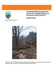
This home in the Talking Rock Estates property is representative of a home at increased risk from wildland fire due to position on slope and proximity to wildland fuel.
The following report is a collaborative effort between various entities. The representatives listed comprise the core decision-making team responsible for this report and mutually agree on the plan's contents.
Community Representatives Name Judy Bailey Chairperson District 1
Address 217 Webb Rd SW Calhoun, GA 30701 Phone Number 706-629-5923
Signature
Name Address Phone Number Signature
Chad Stewart Commissioner District 2 307 Cook Rd Resaca, GA 30735 706-629-3795
Name Address Phone Number Signature
Alvin Long Commissioner District 3 398 Cumberland Dr. NE Calhoun, GA 30701 706-629-2832
Name Address Phone Number Signature
Rebecca Hood Vice-Chairperson District 4 P.O. Box 580 Calhoun, GA 30703 706-629-3795
Name Address Phone Number Signature
George "Duck" Townsend Commissioner District 5 11018 Fairmount Hwy. SE Fairmount, GA 30139 706-337-2412
Emergency Services Representatives
Name Address Phone Number Signature
David Hawkins Fire Chief 400 Belwood Rd. SE Calhoun, GA 30701 706-629-8851
Name Address Phone Number Signature
Richard Cooper Director Emergency Management 4543 Fairmount Hwy. Calhoun, GA 30701 706 602-2905
Local Georgia Forestry Commission Representative(s): Name Vicky Edge Chief Ranger Sr. Gordon Murray unit
Address Georgia Forestry Commission 705 Old Ellijay Rd. Chatsworth, GA 30705 Phone Number (706) 695- 3422 Office (706) 695-7352Fax
Signature
Name Address Phone Number Signature
Adam Greeson Ranger 1Gordon Murray unit 311 Old Fairmount Hwy SE Calhoun GA 30701 (706) 624-1432 Office (706) 624-1372 Fax
Name Address Phone Number Signature
Kenneth Harkins Ranger 1 Gordon Murray unit 311 Old Fairmount Hwy SE Calhoun GA 30701 (706) 624-1432 Office (706) 624-1372 Fax
Name Address Phone Number Signature
Kevin Cline Ranger 1 Gordon Murray unit Georgia Forestry Commission 705 Old Ellijay Rd. Chatsworth, GA 30705 (706) 695- 3422 Office (706) 695-7352Fax
Name Address Phone Number Signature
Matt Rymer Ranger 1 Gordon Murray unit Georgia Forestry Commission 705 Old Ellijay Rd. Chatsworth, GA 30705 (706) 695- 3422 Office (706) 695-7352Fax
Name Address Phone Number Signature
Carl Melear CWPP Specialist Forest Protection P.O. Box 31 Armuchee, GA 30105 706-232-8988
Local USDA Forest Service Representative: Name Mike Davis Assistant Fire Management Officer
Address US Forest Service Chattahoochee-Oconee NF Gainesville, GA 30501 Phone Number 770-297-3034
Signature
PLAN CONTENTS
1. Objectives and Goals 2. County Background, Existing Situation, Interface information 3. Risk Summary 4. Prioritized Mitigation Recommendations 5. Action Plan, Timetables, and Assessment Strategy 6. Wildfire Pre-Suppression Plan 7. County Base and Hazards Maps 8. Appendix
1) OBJECTIVES AND GOALS
The mission of the following report is to set clear priorities for the implementation of wildfire mitigation in Gordon County. The plan includes prioritized recommendations for the appropriate types and methods of fuel reduction and structure ignitability reduction that will protect this county and its essential infrastructure. Prioritized activities to educate the public are included. It also includes a plan for wildfire suppression. Specifically, the plan includes community-centered actions that will:
Educate citizens on wildfire, its risks, and ways to protect lives and properties,
Support fire rescue and suppression entities,
Focus on collaborative decision-making and citizen participation,
Develop and implement effective mitigation strategies, and
Develop and implement effective community ordinances and codes.
This plan should become a working document that is shared by local, state, and federal agencies that will use it to accomplish common goals. It is intended to be incorporated into the master Hazard mitigation plan for the County. An agreed-upon schedule for meeting to review accomplishments, solve problems, and plan for the future should extend beyond the scope of this plan. Without this follow up this plan will have limited value.
2) COUNTY BACKGROUND AND EXISTING SITUATION
Gordon County
Gordon County, in the Valley and Ridge section of northwest Georgia, is the only county along the Interstate 75 corridor that is not part of a metropolitan statistical area. With a population of 44,104 in 2000, the fast-growing county contains five incorporated municipalities: Calhoun, Resaca, Fairmount, Plainville, and Ranger. Gordon County was established in 1850 and named for General William Washington Gordon, a state senator and the first president of the Central of Georgia Railway. That same year Calhoun, on the Western and Atlantic Railroad, was made the county seat. The city was named for John C. Calhoun, U.S. senator and vice president.
Before the county was established, the last eastern capital of the Cherokee Nation
flourished at New Echota, where the Coosawattee and Conasauga rivers join to form the
Oostanaula River. From this site many Cherokees were driven westward along the Trail
of Tears in 1838-39 to present-day Oklahoma. Before the removal Sequoyah had
developed a syllabary for the Cherokee language, the first written language form for
Print Shop
American Indians. A dual-language newspaper, the Cherokee Phoenix, was published at New Echota. After the Cherokee removal the lands were distributed by lottery to white
settlers. Today at the New Echota Historic Site reconstructions of the Cherokee town buildings attract visitors and
several festivals each year. Statues of Sequoyah stand in the city park near the CalhounGordon County Library and
at the Arch, a Civil War (1861-65) monument on the northern edge of Calhoun.
General William T. Sherman took the early stages of the campaign for Atlanta directly through Gordon County, making his headquarters for a time in Calhoun, at what is now Oakleigh, the home of the Gordon County Historical Society. In May each year the Battle of Resaca is reenacted on fields in the northern part of the county, and the battle's fallen are commemorated in a ceremony at the Confederate cemetery there. Near the cemetery on U.S. Highway 41, a Works Progress Administration workforce built a stone monument mapping troop movements in the area.
Superior Court House
Agriculture became strong as the county recovered from the effects of the Civil War, particularly wheat, corn, oats, and cotton. In the early twentieth century cotton mills set in motion an economic force that continues to this day in the carpet and textile industries. Transportation patterns in the county through the years moved from Indian trails to wagon paths, rivers, highways, and finally the air. Interstate Highway 75 came through the county in the mid-twentieth century, and the Tom B. David Field for private aircraft also linked Gordon County with the nearby cities of Atlanta and Chattanooga, Tennessee.
Gordon County Courthouse
Eight schools in the Gordon County school system serve more than 6,000 students. Gordon Central High School and Sonoraville East Middle School have been named Georgia Schools of Excellence. In 1997 Coosa Valley Technical College (later Georgia Northwestern Technical College) established a Gordon County campus. The Calhoun-Gordon Council for a Literate Community sponsors an adult learning center.
A noted resident of Gordon County was the tenor Roland Hayes, born to former slaves on a farm near Curryville. Hayes was acclaimed in Europe and the British Isles at a time when prejudice barred him from many concert halls in his native land. J. M. Henson, a southern gospel musician, and Bert Lance, director of the Office of Management and Budget during the administration of U.S. president Jimmy Carter, are also from Gordon County.
The Harris Arts Center, opened in 2000 by the Calhoun-Gordon Arts Council, also houses an art gallery, dance studio, art and music classrooms, offices, and meeting space, as well as the Roland Hayes Museum, which has a small exhibition honoring Hayes's life. The Clarence E. Harris and Milton M. Ratner Foundations have contributed to this and many other amenities in the county.
Two recreation facilities in Calhoun, Salacoa Creek Park in the county, John's Mountain Wildlife Management Area in the Chattahoochee National Forest near the western edge of Gordon County, and two eighteen-hole public golf courses are popular magnets for those enjoying the temperate climate of this region. The Cherokee Capital Fair is an attraction in the fall.
Gordon County Park
Cherokee Capital Fair
Fire History and Existing Situation
Gordon County has been fortunate not to have had a serious Wildland Fire problem. This is due to improvements and cooperation between responding agencies as well as fragmentation of the surface fuels that are available during prime burning periods. During the five year period that encompassed fiscal years 2007 through 2011, Gordon County averaged 21.8 fires each year that burned an average of 152.85. The following table outlines fire activity in Gordon County for the past five complete fiscal years (July June). Thus far in fiscal year 2012 which began on July 1, 2011, there have been 18 fires that burned 231.12 acres.
Fiscal Year
2011 2010 2009 2008 2007
Number of Fires
26 8 18 22 35
Acres
104.62 8.76 85.37
239.29 326.19
Average Size
4.02 1.10 4.74 10.88 9.32
Statewide Average Size
16.16 3.56 3.90 4.46 18.64
Gordon County is typical of many North Georgia counties in which Incendiarism occurs. The problem is not quite as pronounced as it is in other counties in Northwest Georgia however. Incendiarism was the leading cause in FY 2007,2010 and in 2011. Generally speaking, Gordon County experiences fires across the spectrum of most all causes. Machine use and escaped debris burns remain a common cause. The following table outlines fire activity for the most recent complete fiscal year ending June 30, 2011.
County = Gordon
Cause
Fires
Campfire
Campfire
1
Children
Children
3
Debris: Ag Fields, Pastures, Orchards, Etc
Debris: Ag Fields, Pastures, Orchards, Etc
1
Debris: Construction Land Clearing
Debris: Construction Land Clearing
0
Debris: Escaped Prescribed Burn
Debris: Escaped Prescribed Burn
0
Debris: Household Garbage
Debris: Household Garbage
2
Debris: Other
Debris: Other
0
Debris: Residential, Leafpiles, Yard, Etc
Debris: Residential, Leafpiles, Yard, Etc
7
Debris: Site Prep - Forestry Related
Debris: Site Prep - Forestry Related
0
Incendiary
Incendiary
6
Lightning
Lightning
0
Machine Use
Machine Use
1
Miscellaneous
Miscellaneous
5
Railroad
Railroad
0
Totals for County: Gordon Year: 2011
26
Acres
14.53 5.76 2.43
0.00
0.00 9.21 0.00 9.16
0.00 51.33
0.00 4.76 7.44 0.00 104.62
Fires 5 Yr Avg
0.40
1.40
1.60
Acres 5 Yr Avg
33.51
1.92
3.16
0.80
2.70
0.20
1.46
1.40
4.71
1.40
4.40
4.40 35.30
0.20
3.80 1.40 2.20 2.40 0.20 21.80
3.80
26.06 5.95
23.31 6.54 0.01 152.
The map located in the appendix entitled `Fire Occurrence areas Gordon County' depicts data from fire reports submitted by the Georgia Forestry Commission during the period 1997 2002. It is a representation of the number of starts within a 1000 acre grid applied to the county landscape.
The Wildland-Urban Interface
There are many definitions of the Wildland-Urban Interface (WUI), however from a fire management perspective it is commonly defined as an area where structures and other human development meet or intermingles with undeveloped wildland or vegetative fuels. As fire is dependent on a certain set of conditions, the National Wildfire Coordinating Group has defined the wildland-urban interface as a set of conditions that exists in or near areas of wildland fuels, regardless of ownership. This set of conditions includes type of vegetation, building construction, accessibility, lot size, topography and other factors such as weather and humidity. When these conditions are present in certain combinations, they make some communities more vulnerable to wildfire damage than others. This "set of conditions" method is perhaps the best way to define wildland-urban interface areas when planning for wildfire prevention, mitigation, and protection activities.
There are three major categories of wildland-urban interface. Depending on the set of conditions present, any of these areas may be at risk from wildfire. A wildfire risk assessment can determine the level of risk.
1. "Boundary" wildland-urban interface is characterized by areas of development where homes, especially new subdivisions, press against public and private wildlands, such as private or commercial forest land or public forests or parks. This is the classic type of wildlandurban interface, with a clearly defined boundary between the suburban fringe and the rural countryside.
2. "Intermix" wildland-urban interface areas are places where improved property and/or structures are scattered and interspersed in wildland areas. These may be isolated rural homes or an area that is just beginning to go through the transition from rural to urban land use.
3. "Island" wildland-urban interface, also called occluded interface, are areas of wildland within predominately urban or suburban areas. As cities or subdivisions grow, islands of undeveloped land may remain, creating remnant forests. Sometimes these remnants exist as parks, or as land that cannot be developed due to site limitations, such as wetlands. (courtesy Fire Ecology and Wildfire Mitigation in Florida 2004)
Gordon County is undergoing a transition from a relatively rural county to one that is undergoing development of both boundary and intermix interface. Influence from the I-75 corridor as well as moderate development continues to increase interface problems. Development has slowed somewhat due to the downturn in the economy.
Wildland Urban Interface Hazards
Firefighters in the wildland urban interface may encounter hazards other than the fire itself, such as hazardous materials, utility lines and poor access.
Hazardous Materials Common chemicals used around the home may be a direct hazard to firefighters from flammability, explosion potential and/or vapors or off-gassing. Such chemicals include paint, varnish and other flammable liquids; fertilizer; pesticides; cleansers; aerosol cans, fireworks, batteries and ammunition. In addition, some common household products such as plastics may give off very toxic fumes when they burn. Stay OUT of the smoke from burning structures and any unknown sources such as trash piles.
Illicit Activities Marijuana plantations or drug production labs may be found in wildland urban interface areas. Extremely hazardous materials such as propane tanks and flammable/toxic chemicals may be encountered, as well as booby traps.
Propane tanks Both large (household size) and small (gas grill size) liquefied propane gas (LPG) tanks can present hazards to firefighters, including explosion. See the "LPG Tank Hazards" discussion for details.
Utility lines Utility lines may be located above and below ground and may be cut or damaged by tools or equipment. Don't spray water on utility lines or boxes.
Septic tanks and fields Below-ground structures may not be readily apparent and may not support the weight of engines or other apparatus.
New construction materials Many new construction materials have comparatively low melting points and may "off-gas" extremely hazardous vapors. Plastic decking materials that resemble wood are becoming more common and may begin softening and losing structural strength at 180 F, though they normally do not sustain combustion once direct flame is removed. However, if they continue to burn they exhibit the characteristics of flammable liquids.
Pets and livestock Pets and livestock may be left when residents evacuate and will likely be highly stressed, making them more inclined to bite and kick. Firefighters should not put themselves at risk to rescue pets or livestock.
Evacuation occurring Firefighters may be taking structural protection actions while evacuations of residents are occurring. Be very cautious of people driving erratically. Distraught residents may refuse to leave their property, and firefighters may need to disengage from fighting fire to contact law enforcement officers for assistance. In most jurisdictions firefighters do not have the authority to force evacuations. Firefighters should not put themselves at risk trying to protect someone who will not evacuate!
Limited access Narrow one-lane roads with no turn-around room, inadequate or poorly maintained bridges and culverts are frequently found in wildland urban interface areas. Access should be sized-up and an evacuation plan for all emergency personnel should be developed.
3) Risk Summary
Following an initial meeting held on December 8, 2010 attended by personnel from the Georgia Forestry Commission and Gordon County Fire Service an assessment was made of communities at risk in Gordon County. Decisions on where to make assessments were based on guidance from CWPP specialist Carl Melear who provided data from the Southern Fire Risk Assessment. Assessments were made in the spring and summer of 2011 by personnel of the Gordon County unit of the Georgia Forestry Commission using the GFC form 140 Woodland Community Wildfire hazard assessment and were declared complete on August 30. 2011. Twenty Six (26) areas were assessed. Of these, 1 was considered to be at extreme risk, 13 were considered moderate, and 12 were considered low. Findings from the assessment process are summarized in a spreadsheet entitled `Risk Summary for Gordon County' which is located in the appendix. These areas are designated on the map entitled Wildland Fire Susceptibility Index located in the appendix. The map numbers in the Risk Summary spreadsheet correspond to the numbers on this map. Original copies of the assessments are retained by the Gordon unit of the Georgia Forestry Commission. The original assessments contain more specific information and field notes made by the assessor. This could be helpful to local stations in making specific steps toward hazard mitigation for a particular area. Opportunities for community assessment are still available in the County.
4) Prioritized Mitigation Recommendations
The following recommendations were developed during follow-up meetings with County and State fire response agencies. A priority order was determined based on which mitigation projects would best reduce the hazard of wildland fire to communities and infrastructure. The following priorities were considered. It was acknowledged that in light of incendiary fire being a common cause in the county, protocol for investigation needs to be standard practice. Community Hazard and Structural Ignitability Reduction Wildland Fuel reduction or modification Improvements to capabilities of Wildland response agencies Public Education regarding risk of wildland fire
Proposed Community Hazard and Structural Ignitability Reduction Priorities
Hazard Incendiarism
Mitigation Standardized investigation
Lack of defensible space
Access problems for initial attack
Improve defensible space around structures in communities at risk
Improve access problems
Structural Ignitability
Reduce structural ignitability
Local Codes and Ordinances
Improve and amend to codes and ordinances pertaining to infrastructure and community protection from wildland fire.
Method Utilizing state and federal fire reports, investigations should be conducted on all fires determined to be caused by Incendiarism on each jurisdiction. Coordination across agencies and possibly geographic boundaries should be common practice. All departments should examine structures in communities at risk in their response areas. Improvements to defensible space as referenced in Firewise guidelines should be conveyed to residents through media or direct contact. All County response agencies and the Georgia Forestry Commission should closely examine access in all communities identified to be at risk. When problems are identified corrective measures should be made if possible to do so. Citizens in communities at risk should be educated regarding methods to reduce structural ignitability as referenced in Firewise guidelines. This can be accomplished through media or direct contact. Examine all existing codes and ordinances for problems regarding direct conflicts to wildland safety or lack of needed codes or enforcement.
Proposed Wildland Fuel Reduction or modification Priorities
Hazard Fuel Hazards near Communities at risk
Mitigation Prescribed Burning
Fuel Hazard in public or shared spaces
Fuel Modification or reduction
Method Determine Communities at risk where Prescribed burning would be appropriate to use. Seek cooperation from adjacent landowners. Find funding to cover cost of burning. Prioritize burn compartments and execute. Install permanent firebreaks where burning is inappropriate or opposed by local residents. Determine where hazards exist. Determine appropriate method for modification or reduction. Chipping, raking and piling, County pick-up, Organized Community Clean-up days could be beneficial. Organized burning could be conducted on these days supported by local fire department personnel.
Proposed Improvements to capabilities of Wildland Response Agencies Priorities
Problem or need Lack of qualification or training
Improvement or solution Provide training opportunities
Equipment needs
Improve or acquire Wildland fire equipment
Details
Examine training records of all wildland responders to insure training and qualifications match expected duties. Insure that all wildland responders have Basic Wildland Certification. Locate and secure funding for enhanced training from state and federal agencies. Determine specific equipment needs to bring all wildland response equipment to NWCG Standards. Provide appropriate PPE to all County wildland responders. Provide wildland hand tools to County departments including rakes, shovels, and wind brooms (blowers). Investigate needs for improvements to wildland water handing and supply (dry hydrants, brush trucks, hose, etc.)
Proposed Public Education Priorities
Educational Priority Increase public awareness concerning Firewise principles and fire prevention through direct contact Increase public awareness concerning Firewise principles and fire prevention through use of media
Responsible party Federal, State, County, and municipal governments
County, State, and municipal governments
Increase public awareness concerning Firewise principles and fire prevention through formal certification and recognition
Federal, State, County, and municipal governments
Method
Conduct Firewise meetings by each fire response jurisdiction assisted by Georgia Forestry Commission (state) and USDA Forest Service (federal). Conduct a door to door campaign in particularly hazardous communities
Use PSA's in local newspapers and local radio stations. Utilize Firewise displays in local post offices and banks. Seek use of local EMC newsletter for Firewise message. Create poster sized notices for use in common public places (stores, post offices, etc. adjacent to high hazard areas advising residents about the hazard and how to protect themselves and their property. Distribute public notices concerning Firewise at local sporting events and other public gatherings. Supported by the USFS and the Georgia Forestry Commission each local fire station should set a goal of achieving Firewise status for at least one extreme or high risk category community before the end of calendar year 2012. The goal of adding at least one community annually should extend beyond this initial goal.
5) Action Plan, Timetables, and Assessment Strategy
POTENTIAL FUNDING SOURCES:
As funding is questionable in these times of tight government budgets and economic uncertainty, unconventional means should be identified whereby the need for funding can be reduced or eliminated. Publications / Brochures FIREWISE materials are available at www.firewise.org. Another source of mitigation information can be found at www.nfpa.org. Access to reduce cost or free of charge copy services should be sought whereby publications can be reproduced. Free of charge public meeting areas should be identified where communities could gather to be educated regarding prevention and firewise principles.
Mitigation Community Protection Grant: o USFS sponsored prescribed burn program. Communities with at risk properties that lie within 3 miles of
the USFS border may apply with the GFC to have their forest land prescribed burned free of charge. FEMA Mitigation Policy MRR-2-08-01: through GEMA - Hazard Mitigation Grant Program (HMGP) and
Pre Disaster Mitigation (PDM) o To provide technical and financial assistance to local governments to assist in the implementation of
long term cost effective hazard mitigation measures. o This policy addresses wildfire mitigation for the purpose of reducing the threat to all-risk structures
through creating defensible space, structural protection through the application of ignition resistant construction, and limited hazardous fuels reduction to protect life and property. o With a complete and registered plan (addendum to the State plan) counties can apply for premitigation funding. They will also be eligible for HMGP if the county is declared under a wildfire disaster. GFC - Plowing and burning assistance can be provided through the Georgia Forestry Commission as a low cost option for mitigation efforts. Secure Rural Schools and Community Self Determination Act o These funds are designated for Firewise Communities, Community Wildfire Protection Plan Development, and emergency operations on federal lands.
Individual Homeowners In most cases of structural protection ultimately falls on the responsibility of the community and the
homeowner. They will bear the cost; yet they will reap the benefit from properly implemented mitigation efforts. GEMA Grant - PDM (See above)
Ultimately it is our goal to help the communities by identifying the communities threatened with a high risk to wildfire and educate those communities on methods to implement on reducing those risks.
5) Action Plan
Steps to implement Community Hazard and Structural Ignitability Priorities
Hazard Incendiarism
Lack of Defensible Space
Access problems
Structural Ignitability
Codes and Ordinances
Specific Action and Responsible Party The Georgia Forestry Commission and USDA Forest Service should conduct investigations on all fires determined to be caused by Incendiarism on their jurisdictions. Cooperation and resource sharing (investigators) should be made standard practice. The use of local law enforcement should be standard practice especially when arson is identified as a problem in a specific area. The use of reward based incentives to locate arsonists should be considered. Using the risk summaries referenced in section 3, each department should conduct inspections of communities at risk in their jurisdiction or area of response for lack of defensible space. Findings will be conveyed to residents and treatment methods will be recommended in accordance with Firewise principles. This would probably be best accomplished by approaching homeowners associations or organizations. Ultimately, the message should reach individual homeowners in each community. Should local organizations not exist, the builder or developer could be contacted. Such contacts would also influence future projects or developments Using the risk summary table and level of concern maps, the Georgia Forestry Commission and Gordon County Fire officials should visit all identified communities at risk for the purpose of locating and resolving access difficulties. This inspection should extend into the wildland adjacent to the communities at risk looking for hindrances to suppression tactics Gordon County Fire officials should examine structures for structural ignitability concerns at the time when the communities at risk are inspected for lack of defensible space. Using Firewise guidelines for reducing structural ignitability, (a checklist could be formulated and used) structures should be assessed and findings conveyed to residents. This could be through use of media or by direct contact with residents or homeowners associations. Gordon County and municipal Fire Marshalls should closely examine all codes and ordinances for gaps and oversights which could cause problems in the wildland fire arena. Examples include proximity of propane tanks to structures, accumulations of debris, lack of proper identification pertaining address or street names, set back distances from wildland fuels, and road widths in new developments.
In regard to priority, the above steps should first extend to the higher numbers in the extreme category from the risk summary as these communities are at a higher degree of risk.
5) Action Plan
Steps to implement Fuel Reduction or Modification Priorities
Hazard Hazardous Wildland Fuel Accumulations
Fuel Continuity between Wildland and Woodland Communities
Hazardous Fuel Accumulations in communities and hindrances to suppression
Specific Action and Responsible Party The Georgia Forestry Commission will prioritize prescribed burning projects on non-federal lands adjacent to Communities at risk where burning is determined to be appropriate. A suggested project is shown for the homes along and near Possum Hollow Rd. on a photograph in the appendix. Prescribed burn goals set by the U S Forest Service should also take fuel reduction near communities at risk into consideration as part of the prescription. Both agencies should work toward planning to see any proposed burn projects could be done concurrently. This will require changes in how these burns are carried out as regards logistics and technique. In areas where the need exists and fuel reduction by burning is determined to be inappropriate, permanent or semi-permanent fuel breaks could be established. These breaks should be maintained annually prior to the arrival of prime burning times. Their locations should be mapped and made known to local, state, and federal response personnel. Residents of the Communities adjacent to these breaks should be advised of their purpose and their cooperation in protecting them should be gained. These breaks could be installed by the Georgia Forestry Commission. Using the risk summary in section 3, Fire departments could conduct community clean up days in communities at risk in their respective jurisdictions aimed at reducing hazardous fuels and hindrances to suppression in shared community space. Residents would be provided with guidance and access to disposal alternatives for materials removed. Locations for safe burning common to all residents could be located. Should no areas exist for non supported burning, fire departments could consider designated days for burning supported by fire department personnel.
Steps to implement improvements to wildland response capability
Improvement needed Improve training and qualification of Gordon County Wildland firefighters
Improve or acquire wildland fire fighting equipment
Responsible Party and specific action
Chief Ranger Vicky Edge, Assistant District Manager Troy Floyd Jr. of the Georgia Forestry Commission and Gordon County Fire Chief Hawkins should examine all training records for personnel under their supervision. All current or potential wildland personnel should be certified Georgia Basic Wildland Firefighters or higher in qualification. Additional training and qualification should be sought for personnel identified in the Gordon County Fire plan who are assigned specific Incident Command System (ICS) functions. Sources for available funds for training should be sought at State and Federal levels. All stations for Gordon County Fire Departments should inventory their present equipment relating to their wildland capability. Funding sources should be investigated from available grants or other sources. Needs for job specific wildland responsibilities should be examined by Chief Ranger Edge and Fire Chief Hawkins.
5) Action Plan
Steps to educate or inform the Public regarding wildland fire prevention and responsibilities
Opportunity Improve Public Education through direct contact
Improve Public Education through use of media
Improve Public Education through formal certification
Responsible Party and Specific Action Prior to the onset of fire season(s) rangers of the Georgia Forestry Commission and Gordon County Fire personnel should conduct Firewise meetings in conjunction with normally scheduled fire department meetings. People living in or near communities at risk should be invited to these meetings by use of door to door campaigns or by mailbox flyers. Notices regarding these meetings could be placed in local post offices or stores near communities at risk. A Firewise display should be acquired and utilized at this meeting. This display would be retained by the Gordon Murray County units of the Georgia Forestry Commission and used for all Firewise meetings in Gordon and Murray Counties. Local news media should be invited to these meetings. Goals for potential Firewise certified communities in Gordon County could be considered after these meetings are completed. Prior to the onset of fire season(s) or during periods of particularly high fire danger use of the media should be stepped up by personnel of the Georgia Forestry Commission. This should include use of all available media in the County. PSA's should be run weekly during periods of high to extreme fire danger. Signs or poster boards could be developed for display in pubic spaces near communities at risk advising residents that they live in areas that are susceptible to wildland fire and directing them to sources of information regarding wildland fire and their role in improving their own personal safety. Before the end of calendar year 2012 the Georgia Forestry Commission and Gordon County Fire should guide residents in the process to obtain Firewise certification for the community listed below. Should lack of interest or other problems prevent certification of the listed communities an effort should be made with another community listed on the Communities at Risk list. Follow up with additional communities should work toward the goal of adding one community annually.
Talking Rock Creek Properties
5) Action Plan
Timetables for Actions
Steps to implement Community Hazard and Structural Ignitability Priorities
Steps to standardize and coordinate investigation practices should begin as soon as possible between agencies involved.
Steps to examine communities at risk for defensible space and structural ignitability should take prior to the next fire season (late winter 2012).
Pre-planning to examine access and suppression problems should take place at any time during the current burning season.
Codes and Ordinances should be examined as soon as possible in order for the legal workings of changes to take place.
Steps to implement Fuel Reduction or Modification Priorities
Any identified prescribed burn projects should take place in late winter or early spring 2012. Any other priority burn projects or installation of pre suppression fuel breaks should take place during this same window.
Steps to reduce fuels in communities at risk should coincide with steps to improve defensible space and reduce structural ignitability. Timing of these actions would be dependent upon Fire station availability during the late winter of 2011 -2012.
Steps to implement improvements to wildland response capability
Cooperation between state and local wildland suppression forces regarding improvements to training and equipment should begin immediately.
Steps to educate or inform the Public regarding wildland fire prevention and responsibilities
Direct contact with residents in Communities at risk should take place as soon as possible during early calendar year 2012
The use of media should coincide with the above action. Certification of Firewise communities should follow the timetable associated with the action plan
5) Action Plan
Assessment of Actions
Reduction of Community hazard and structural ignitability
. Direct measurement of the number of communities assessed would be the appropriate measure of
success Any meetings that result in cooperation between wildland departments should be logged along with
minutes of those meetings. Goals should be set and reviewed after each meeting. Any changes to or additions to codes and ordinances would be an obvious measure of success. Steps to achieve cooperation across law enforcement agencies would be the most obvious
measure of success as regards Incendiarism reduction. .
Steps to implement Fuel Reduction or Modification Priorities
Acres burned would be the appropriate measure for fuel reduction. A direct measure of linear feet of firebreaks would be an appropriate measure for pre suppression breaks.
Fuel reduction in communities at risk would be measured by the number of communities affected and number of projects completed.
Steps to implement improvements to wildland response capability
A direct measure of the number of capabilities or qualifications gained would be the appropriate measure of success.
Any equipment acquired or any equipment brought up to national standards would be the appropriate measure of success.
Steps to educate or inform the Public regarding wildland fire prevention and responsibilities
Direct measurement of the number of persons contacted, literature distributed, public notices posted, and news articles published, radio programs aired, etc. would be the best measure of success. The number of communities that achieve Firewise status would be an obvious measure of success.
6) Wildfire Pre-Suppression Plan
A recent update of the Georgia Forestry Commission Fire plan is located in the appendix of this plan. This document contains valuable tactical and logistical information related to wildland fire suppression and incident management.
7) County Base and Hazards Maps
Maps of historical fire occurrence, Wildland Fire Susceptibility, Surface Fuels, and a map of the east portion of the Conasauga Ranger District of USDA Forest Service land are included in the appendix of this plan. A photograph depicting a suggested prescribed burn project designed to reduce fuel near homes in the eastern part of the county is included. These maps are in PDF format and are available from the Georgia Forestry Commission. When viewed in this electronic format increased magnification and resolution capabilities are realized which will make these maps more useful. Large format printing capabilities are also realized.
8) Appendix
Risk Summary County Base and Hazard maps Gordon County Pre-Suppression plan
o
P. O. Box 819 Macon, GA 31202 1-800-GA-TREES GaTrees.org
The Georgia Forestry Commission provides leadership, service and education in the protection and conservation of Georgia's forest resources. An Equal Opportunity Employer and Service Provider