- Collection:
- Georgia Government Publications
- Title:
- Community wildfire protection plan, Bartow County: an action plan for wildfire mitigation and conservation of natural resources
- Creator:
- Georgia. Forestry Commission
- Publisher:
- Macon, Ga. : Georgia. Forestry Commission
- Date of Original:
- 2013
- Subject:
- Wildfires--Georgia--Bartow County--Prevention and control
Fire management--Georgia--Bartow County
Chorochromatic maps - Location:
- United States, Georgia, 32.75042, -83.50018
United States, Georgia, Bartow County, 34.23786, -84.8405 - Medium:
- plans (reports)
- Type:
- Text
- Format:
- application/pdf
- External Identifiers:
- OCLC 1164712439
NZ MMS ID 9922026354602931
Call Number F600 .M1 2013 W5 B378 - Metadata URL:
- https://dlg.galileo.usg.edu/id:dlg_ggpd_s-ga-bf600-b-pm1-b2013-bw5-bb378-belec-p-btext
- Digital Object URL:
- https://dlg.galileo.usg.edu/do:dlg_ggpd_s-ga-bf600-b-pm1-b2013-bw5-bb378-belec-p-btext
- Language:
- eng
- Holding Institution:
- University of Georgia. Map and Government Information Library
- Rights:
-

A Program of the Georgia Forestry Commission with support from the U.S. Forest Service
Community Wildfire Protection Plan
An Action Plan for Wildfire Mitigation and Conservation of Natural Resources
Bartow County
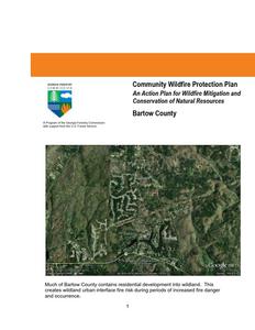
Much of Bartow County contains residential development into wildland. This creates wildland urban interface fire risk during periods of increased fire danger and occurrence.
1
The following report is a collaborative effort between various entities. The representatives listed below comprise the core decision-making team responsible for this report and mutually agree on the plan's contents.
County Representative(s): Name Clarence Brown County Commissioner
Address 135 W. Cherokee Ave. Cartersville, GA 30120 Phone Number 770-387-5030
Signature
Local Fire Department Representative(s): Name Craig Millsap Chief Bartow County Fire Department
Address 5435 Hwy. 20 Cartersville, GA 30121 Phone Number 770-387-5151
Other Contact millsapc@bartowga.org Information Signature
Name Address Phone Number Other Contact Information Signature
Johnny Payne Director Bartow Emergency Management 10 Elizabeth St. Cartersville,GA 30120 770 -387- 5089 paynej@bartowga.org
Local Georgia Forestry Commission Representative(s):
Name Address Phone Number Other Contact Information Signature
Mark Munns Chief Ranger Interim Bartow Cherokee Counties 3700 Hwy. 140 E. Rydal, GA 30171 770 387-3750 mmunns@gfc.state.ga.uss
Name Carl Melear CWPP Specialist Forest Protection Address P.O. Box 31 Armuchee, GA 30105 Phone Number (706) 232-8988 Signature
The following interested parties were consulted and involved in the preparation of this report.
Name
Tim Poe GIS Coordinator Jacqueline Waits GIS Technician
Organization
Bartow County Information Bartow County Information
2
PLAN CONTENTS
1. Objectives and Goals 2. County Background, Existing Situation, Interface Information 3. Risk Summary 4. Prioritized Mitigation Recommendations 5. Action Plan, Timetables, and Assessment Strategy 6. Wildfire Pre-Suppression Plans 7. County Base and Hazards Maps 8. Appendix
1) OBJECTIVES AND GOALS
The mission of the following report is to set clear priorities for the implementation of wildfire mitigation in Bartow County. The plan includes prioritized recommendations for the appropriate types and methods of fuel reduction and structure ignitability reduction that will protect this county and its essential infrastructure. Prioritized activities to educate the public are included. It also includes a plan for wildfire suppression. Specifically, the plan includes communitycentered actions that will:
Educate citizens on wildfire, its risks, and ways to protect lives
and properties,
Support fire rescue and suppression entities,
Focus on collaborative decision-making and citizen
participation,
Develop and implement effective mitigation strategies, and
Develop and implement effective community ordinances and
codes.
This plan should become a working document that is shared by local, state, and federal agencies that will use it to accomplish common goals. It is intended to amend the present County Hazard mitigation plan. An agreed-upon schedule for meeting to review accomplishments, solve problems, and plan for the future should extend beyond the scope of this plan. Without this follow up this plan will have limited value.
3
2) COUNTY BACKGROUND-EXISTING SITUATIONINTERFACE INFORMATION
Bartow County
Bartow County was formed from Cherokee County on December 3, 1832. It was originally called Cass County for General Lewis Cass, secretary of war under U.S. president Andrew Jackson and the man most responsible for the removal of the Cherokee Indians from northwest Georgia. Cass sided with abolitionists during the Civil War (1861-65), however, and in 1861 the county was renamed in honor of the first Georgia officer to fall on the field at Manassas, Virginia, Colonel Francis S. Bartow.
Before white settlement, a Native American population included Woodland Indians, Mississippian Mound Builders, Creeks, and Cherokees, who flourished in the fertile plains of the Etowah Valley for thousands of years. A remnant of one of these cultures, the Etowah Indian Mounds, is a state historic site.
Attracted by abundant natural resources and the promise of gold, white settlers acquired land through the 1832 land lottery and the 1832 gold lottery. The county seat of Cassville was laid out the next year and incorporated in December 1843. It was destroyed during the Civil War by Union forces in November 1864, and the county seat was moved to Cartersville, the next largest municipality, in 1867. Other municipalities include Adairsville, Emerson, Euharlee, Kingston, Taylorsville, and White.
Etowah Indian Mounds
The Western and Atlantic Railroad (W&A), which paralleled present-
day Interstate 75 from Atlanta to Chattanooga, Tennessee, played a
significant role in the early development of the county. During the
Civil War, the W&A was the Confederacy's main corridor through
northwest Georgia and was of some strategic value during Union
Bartow County Courthouse
general William T. Sherman's campaign for Atlanta. One of the shortest and bloodiest battles of the war was waged at the deep cut
of the railroad at Allatoona Pass. The W&A also figured prominently in
the Great Locomotive Chase (also known as the Andrews Raid), which ran through Bartow
County.
The Civil War brought numerous skirmishes to the county, particularly in the areas of Kingston and Cassville, where Confederate cemeteries were established. In 1865 the last remnant of the Confederate army east of the Mississippi was paroled at Kingston.
4
A huge iron belt that runs north to south, almost through the entire eastern length of the county, supported a flourishing iron industry from the 1840s to the 1870s, and evidence of many iron furnaces remains. Chief among iron producers was the Etowah Manufacturing and Mining Company at Etowah, where Cooper's Furnace remains. Iron is no longer mined, but mining and processing of other ores continues. New Riverside Ochre, Vulcan Materials, and Chemical Products are the largest mining industries currently in operation in the county.
Other major industries include Shaw Industries and Anheuser-Busch. Bartow County also serves as the corporate headquarters for Phoenix Air. Until the mid-1970s cotton remained the main crop in this largely agricultural county.
Bartow County is home to Red Top Mountain State Park and Lake
Cooper's Furnace
Allatoona, which occupy a large portion of the southeast corner of the
county. The first African American state park, George Washington Carver, was located in
Bartow; it became part of Red Top park in 1975. Historical attractions include nineteen
National Register listings, among them Adairsville Historic District, Etowah Valley District,
and the North Erwin Street and North Wall Street Historic Districts in
Cartersville.
The county boasts the first outdoor Coca-Cola wall sign, the Euharlee Covered Bridge, and the Friendship Monument in Cartersville. Cultural attractions include museums, performing arts centers, and theatrical companies. Bartow County also hosts the annual Atlanta Steeplechase at Kingston Downs. A campus of Chattahoochee Technical College and a satellite campus for Georgia Highlands College are located in the county, both in the town of Acworth.
Coca-Cola Sign
Notable people from Bartow County include the evangelist Sam Jones, humorist Bill Arp, novelists Corra Harris and Francis Goulding, Baptist missionary Lottie Moon, iron pioneers Jacob Stroup and Moses Stroup, iron industrialist Mark Cooper, major league baseball player Rudy York, Hall of
Barnsley Gardens
Fame horse trainer Huratio Luro, and Confederate generals P.M.B. Young and William Wofford. Distinguished politicians include the first woman U.S. senator, Rebecca Latimer Felton; Senator Jefferson Davis; U.S. attorney general Amos T. Akerman; former chief justice of the Georgia Supreme Court, Robert Benham; former governor Joe Frank Harris; U.S. Congressman William Felton; and member of the Confederate congress Warren Akin Sr.
According to the 2010 U.S. census, the population of Bartow County is 100,157, an increase from the 2000 population of 76,019. As the metropolitan Atlanta area expands, Bartow County's continued growth is assured.
The above material is courtesy of the New Georgia Encyclopedia
5
Existing Situation
Wildland Fire activity in Bartow County has been consistent with historical trends in past years. The County continues to have a problem with incendiary fires which is usually the leading cause of fire. Other causes include debris burning, machine use, fires caused by railroads, lightning, children, and other miscellaneous causes. The following table outlines fire activity for fiscal year (FY 12) which began on July 1, 2011 and ended on June 30, 2012. The average size fire in FY 2012 was 4.93 acres
County = Bartow
Cause
Fires
Campfire
Campfire
3
Children
Children
1
Debris: Ag Fields, Pastures, Orchards, Etc
Debris: Ag Fields, Pastures, Orchards, Etc
0
Debris: Escaped Prescribed Burn
Debris: Escaped Prescribed Burn
0
Debris: Household Garbage Debris: Household Garbage
0
Debris: Other
Debris: Other
1
Debris: Residential, Leafpiles, Debris: Residential, Leafpiles,
Yard, Etc
Yard, Etc
2
Debris: Site Prep - Forestry Related
Debris: Site Prep - Forestry Related
1
Incendiary
Incendiary
24
Lightning
Lightning
3
Machine Use
Machine Use
6
Miscellaneous
Miscellaneous
9
Railroad
Railroad
1
Totals for County: Bartow Year: 2012
51
Acres
2.97 0.25 0.00
Fires 5 Yr Avg
2.40
3.80
1.60
Acres 5 Yr Avg
10.43
6.67
19.90
0.00
0.40
6.80
0.00
0.20
0.90
0.23
0.60
1.25
19.03
0.80
4.11
1.53
0.20
0.31
147.97 7.50
19.18 49.48
3.50
14.00 3.00 7.00 4.00 0.60
71.82 22.84 42.22 15.75
0.76
251.64 38.60 203.75
Copyright Georgia Forestry Commission 1998-2012. All rights reserved.
6
The following table outlines fire activity for fiscal years 2008 through 2012. As can be seen activity was greatly reduced in FY 2010 statewide due to increased rainfall. The table is followed by an occurrence map for fiscal years 2007 - 2011. There is also a map in the appendix that outlines historical fire occurrence areas for fires responded to by the Georgia Forestry Commission during the period 1997 2002. This map shows number of wildland fire starts within a 1000 acre grid applied to the County landscape.
Fiscal Year
2012 2011 2010 2009 2008
Number of Fires in Bartow County 51 67 13 25 37
Number of Fires Statewide Average
34 58 23 34 39
Acres burned in Bartow County 251.64 353.90
99.50 108.60 205.10
Average Size in Bartow County
4.93 5.28 7.65 4.34 5.54
Statewide Average Size
4.98 16.16 3.56 3.90 4.56
7
The Wildland-Urban Interface
There are many definitions of the Wildland-Urban Interface (WUI), however from a fire management perspective it is commonly defined as an area where structures and other human development meet or intermingles with undeveloped wildland or vegetative fuels. As fire is dependent on a certain set of conditions, the National Wildfire Coordinating Group has defined the wildland-urban interface as a set of conditions that exists in or near areas of wildland fuels, regardless of ownership. This set of conditions includes type of vegetation, building construction, accessibility, lot size, topography and other factors such as weather and humidity. When these conditions are present in certain combinations, they make some communities more vulnerable to wildfire damage than others. This "set of conditions" method is perhaps the best way to define wildland-urban interface areas when planning for wildfire prevention, mitigation, and protection activities.
There are three major categories of wildland-urban interface. Depending on the set of conditions present, any of these areas may be at risk from wildfire. A wildfire risk assessment can determine the level of risk.
1. "Boundary" wildland-urban interface is characterized by areas of development where homes, especially new subdivisions, press against public and private wildlands, such as private or commercial forest land or public forests or parks. This is the classic type of wildland-urban interface, with a clearly defined boundary between the suburban fringe and the rural countryside.
2. "Intermix" wildland-urban interface areas are places where improved property and/or structures are scattered and interspersed in wildland areas. These may be isolated rural homes or an area that is just beginning to go through the transition from rural to urban land use.
3. "Island" wildland-urban interface, also called occluded interface, are areas of wildland within predominately urban or suburban areas. As cities or subdivisions grow, islands of undeveloped land may remain, creating remnant forests. Sometimes these remnants exist as parks, or as land that cannot be developed due to site limitations, such as wetlands. (courtesy Fire Ecology and Wildfire Mitigation in Florida 2004)
Bartow County is typical of a county that is undergoing a rapid transition from an isolated rural county to a more urbanized county. This transition resulted from influence of the expanding Atlanta metropolitan area. Access to Interstate I-75 has influenced increased development of residential areas in Bartow County. This trend has slowed somewhat in recent years due to reduced housing growth but should this trend reverse development will undoubtedly resume.
8
Wildland Urban Interface Hazards Firefighters in the wildland urban interface may encounter hazards other than the fire itself, such as hazardous materials, utility lines and poor access.
Hazardous Materials Common chemicals used around the home may be a direct hazard to firefighters from flammability, explosion potential and/or vapors or off-gassing. Such chemicals include paint, varnish and other flammable liquids; fertilizer; pesticides; cleansers; aerosol cans, fireworks, batteries and ammunition. In addition, some common household products such as plastics may give off very toxic fumes when they burn. Stay OUT of the smoke from burning structures and any unknown sources such as trash piles.
Illicit Activities Marijuana plantations or drug production labs may be found in wildland urban interface areas. Extremely hazardous materials such as propane tanks and flammable/toxic chemicals may be encountered, as well as booby traps.
Propane tanks Both large (household size) and small (gas grill size) liquefied propane gas (LPG) tanks can present hazards to firefighters, including explosion. See the "LPG Tank Hazards" discussion for details.
Utility lines Utility lines may be located above and below ground and may be cut or damaged by tools or equipment. Don't spray water on utility lines or boxes.
Septic tanks and fields Below-ground structures may not be readily apparent and may not support the weight of engines or other apparatus.
9
10
New construction materials Many new construction materials have comparatively low melting points and may "off-gas" extremely hazardous vapors. Plastic decking materials that resemble wood are becoming more common and may begin softening and losing structural strength at 180 F, though they normally do not sustain combustion once direct flame is removed. However, if they continue to burn they exhibit the characteristics of flammable liquids.
Pets and livestock Pets and livestock may be left when residents evacuate and will likely be highly stressed, making them more inclined to bite and kick. Firefighters should not put themselves at risk to rescue pets or livestock.
Evacuation occurring Firefighters may be taking structural protection actions while evacuations of residents are occurring. Be very cautious of people driving erratically. Distraught residents may refuse to leave their property, and firefighters may need to disengage from fighting fire to contact law enforcement officers for assistance. In most jurisdictions firefighters do not have the authority to force evacuations. Firefighters should not put themselves at risk trying to protect someone who will not evacuate!
Limited access Narrow one-lane roads with no turn-around room, inadequate or poorly maintained bridges and culverts are frequently found in wildland urban interface areas. Access should be sized-up and an evacuation plan for all emergency personnel should be developed.
There is a map in the appendix which shows the track of the tornado which occurred on April 27, 2011. Firefighting in areas affected by this storm will be extremely difficult and dangerous should they remain unchanged from when they occurred. Structures in close proximity to this track are at heightened risk.
11
3) Risk Summary
Following a meeting between the Georgia Forestry Commission and Bartow County Fire and Rescue department personnel on August 29, 2011 assessments of communities at risk from wildland fire was undertaken. This assessment process was based on information provided by the Georgia Forestry Commission from the Southern Fire Risk Assessment supplemented by local knowledge of high risk areas. Communities were assessed using the Georgia Forestry Commissions Form 140 for Woodland Community Wildfire Hazard Assessment. This form determines risk based on four criteria subdivision design, site hazard, building construction, and additional factors. Communities are assigned a risk category based on a numerical score. Communities are designated as being at extreme, high, moderate, or low risk. Assessments were declared complete on October 26, 2011 The original assessments are retained by the Georgia Forestry Commission. These documents would be useful if they were referenced to determine how risk categories could be improved. Sixty Three (63) communities were assessed. Of these, eight (8) were classified as being at extreme risk, seven (7) were at high risk, forty two (42) were at moderate risk, and six (6) were classified as being at low risk. Information on the assessed communities is shown on a spreadsheet entitled `Risk Summary Bartow County' which is included in the appendix. This document contains summary information from the assessment forms. The locations for the communities are shown on jurisdiction maps for Bartow County. There is also an overview map of all jurisdictions. All maps are in PDF format which allows for file sharing and printing in all formats.
12
4) Prioritized Mitigation Recommendations
The following recommendations were developed by collaboration between the Georgia Forestry Commission and various County Fire and Emergency Services. A priority order was determined based on which mitigation projects would best reduce the hazard of wildfire in the assessment area. It is noted that
as incendiary fire remains the leading cause in the county, all fires that are determined to be caused by arson should be investigated as standard practice.
Community Hazard and Structural Ignitability Reduction Wildland Fuel Reduction or Modification Improvements to Capabilities of Wildland Response Agencies Public Education Regarding Risk of Wildland Fire
Proposed Community and Structural Ignitability Reduction Priorities:
1. Locate lack of and improve defensible space around structures in communities at risk 2. Identify access problems that affect initial attack in communities at risk 3. Identify structural ignitability concerns in communities at risk 4. Identify and resolve problems with codes, covenants, or ordinances that negatively influence
structural ignitability
Proposed Wildland Fuel Reduction or Modification Priorities:
1. Reduction or modification of wildland fuel in proximity to communities at risk 2. Reduction or modification of fuel concentrations in shared spaces inside
communities at risk
Proposed Improvements to capabilities of Wildland Response agencies:
1. Identify needs and improve training and qualification of wildland response agencies
2. Identify needs and recommend equipment acquisitions for wildland response agencies
Proposed Education and Outreach Priorities:
1. Improve public knowledge in communities at risk and in the general population of the County regarding Firewise principles.
2. Notification of communities at risk regarding wildland fire hazard 3. Improvements to public notification during periods of high to extreme fire
danger.
13
5) Action Plan, Timetables, and Assessment Strategy
POTENTIAL FUNDING SOURCES:
As funding is questionable in these times of tight government budgets and economic uncertainty, unconventional means should be identified whereby the need for funding can be reduced or eliminated. Publications / Brochures FIREWISE materials are available at www.firewise.org. Another source of mitigation information can be found at www.nfpa.org. Access to reduced cost or free of charge copy services should be sought whereby publications can be reproduced. Free of charge public meeting areas should be identified where communities could gather to be educated regarding prevention and firewise principles.
Mitigation Community Protection Grant: o USFS sponsored prescribed burn program. Communities with at risk properties
that lie within 3 miles of the USFS border may apply with the GFC to have their forest land prescribed burned free of charge. FEMA Mitigation Policy MRR-2-08-01: through GEMA - Hazard Mitigation Grant Program (HMGP) and Pre Disaster Mitigation (PDM) o To provide technical and financial assistance to local governments to assist in the implementation of long term cost effective hazard mitigation measures. o This policy addresses wildfire mitigation for the purpose of reducing the threat to all-risk structures through creating defensible space, structural protection through the application of ignition resistant construction, and limited hazardous fuels reduction to protect life and property. o With a complete and registered plan (addendum to the State plan) counties can apply for pre- mitigation funding. They will also be eligible for HMGP if the county is declared under a wildfire disaster. GFC - Plowing and burning assistance can be provided through the Georgia Forestry Commission as a low cost option for mitigation efforts.
Individual Homeowners In most cases of structural protection ultimately falls on the responsibility of
the community and the homeowner. They will bear the cost; yet they will reap the benefit from properly implemented mitigation efforts. GEMA Grant - PDM (See above)
Ultimately it is our goal to help the communities by identifying the communities threatened with a high risk to wildfire and educate those communities on methods to implement on reducing those risks.
14
5) Action Plan
Bartow County has had a consistent history of incendiary fires in most
years. All fires that are attributed to this cause should be investigated by
the appropriate agency having jurisdiction.
Steps to implement Community Hazard and Structural Ignitability
Priorities
Hazard
Specific Action and Responsible Party
Lack of
Using the risk summaries referenced in section 3, each
Defensible
department should conduct inspections of communities at risk
Space
in their jurisdiction or area of response for lack of defensible
space. Findings will be conveyed to residents and treatment
methods will be recommended in accordance with Firewise
principles. This would probably be best accomplished by
approaching homeowners associations or organizations.
Ultimately, the message should reach individual homeowners
in each community. Should local organizations not exist, the
builder or developer could be contacted. Such contacts would
also influence future projects or developments
Access
Using individual Communities at Risk maps for each station,
problems
the Georgia Forestry Commission and Bartow County Fire
officials should visit all identified communities at risk for the
purpose of locating and resolving access difficulties. This
inspection should extend into the wildland adjacent to the
communities at risk looking for hindrances to suppression
tactics
Structural
Bartow County Fire officials should examine structures for
Ignitability
structural ignitability concerns at the time when the
communities at risk are inspected for lack of defensible space.
Using firewise guidelines for reducing structural ignitability, (a
checklist could be formulated and used) structures should be
assessed and findings conveyed to residents. This could be
through use of media or by direct contact with residents or
homeowners associations.
Codes and
Bartow County and municipal Fire Marshalls should closely
Ordinances
examine all codes and ordinances for gaps and oversights
which could cause problems in the wildland fire arena.
Examples include proximity of propane tanks to structures,
accumulations of debris, lack of proper identification pertaining
address or street names, set back distances from wildland
fuels, road widths in new developments.
In regard to priority, the above steps should first extend to the higher numbers in the extreme category from the risk summary as these communities are at a higher degree of risk.
15
5) Action Plan
Steps to implement Fuel Reduction or Modification Priorities
Hazard Hazardous Wildland Fuel Accumulations
Fuel Continuity between Wildland and Woodland Communities
Hazardous Fuel Accumulations in communities and hindrances to suppression
Specific Action and Responsible Party The Georgia Forestry Commission will prioritize prescribed burning projects adjacent to Communities at risk where burning is determined to be appropriate. Due to the nature of smaller sizes holdings and steeper terrain, burn projects may have to be small scale and carefully managed. In areas where the need exists and fuel reduction by burning is determined to be inappropriate, permanent or semi-permanent fuel breaks could be established. These breaks should be maintained annually prior to the arrival of prime burning times. Their locations should be mapped and made known to local, state, and federal response personnel. Residents of the Communities adjacent to these breaks should be advised of their purpose and their cooperation in protecting them should be gained. These breaks could be installed by the Georgia Forestry Commission. Using the risk summary in section 3, Fire departments could conduct community clean up days in communities at risk in their respective jurisdictions aimed at reducing hazardous fuels and hindrances to suppression in shared community space. Residents would be provided with guidance and access to disposal alternatives for materials removed.
16
Steps to implement improvements to wildland response capability
Improvement needed Improve training and qualification of Bartow County Wildland firefighters
Improve or acquire wildland fire fighting equipment
Responsible Party and specific action
The Chief Ranger and Assistant District Manager of the Georgia Forestry Commission and Bartow County Fire Chief should examine all training records for personnel under their supervision. All personnel assigned or anticipated to be assigned wildland response responsibilities should be certified Georgia Basic Wildland Firefighter or higher in qualification. Additional training and qualification should be sought for personnel identified in the Bartow County Fire plan who are assigned specific Incident Command System (ICS) functions. Sources for available funds for training should be sought at local, state, and federal levels. All stations for Bartow County Fire Departments should inventory their present equipment relating to their wildland capability. Funding sources should be investigated from available grants or other sources. Needs for job specific wildland responses should be examined by the Georgia Forestry Commission Chief Ranger and the Bartow County Fire Chief .
17
5) Action Plan
Steps to educate or inform the Public regarding wildland fire prevention and responsibilities
Opportunity Improve Public Education through direct contact
Responsible Party and Specific Action Prior to the onset of fire season(s) rangers of the Georgia Forestry Commission and Bartow County Fire personnel should conduct firewise meetings in conjunction with normally scheduled fire department meetings. People living in or near extreme and high risk communities should be invited to these meetings by use of door to door campaigns. Notices regarding these meetings could be placed in local post offices or stores near communities at risk. A Firewise display should be acquired and utilized at this meeting. This display would be retained by the Bartow Cherokee unit of the Georgia Forestry Commission and used for all firewise meetings in those Counties. Local news media should be invited to these meetings. Goals for potential Firewise certified communities in Bartow County could be considered after these meetings are completed.
18
Steps to educate or inform the Public regarding wildland fire prevention and responsibilities
Improve Public Education through use of media
Improve Public Education through formal certification
Prior to the onset of fire season(s) or during periods of particularly high fire danger use of the media should be stepped up by personnel of the Georgia Forestry Commission. This should include use of all available media in the County. PSA's should be run weekly during periods of high to extreme fire danger. Signs or poster boards could be developed for display in pubic spaces near communities at risk advising residents that they live in areas that are susceptible to wildland fire and directing them to sources of information regarding wildland fire and their role in improving their own personal safety. Signs directing residents to the firewise website could be effective. Firewise materials could be provided to the County building permit office. Before the end of calendar year 2012 the Georgia Forestry Commission and Bartow County Fire should obtain Firewise certification for at least one community in the extreme risk category in the risk summary table.
19
5) Action Plan
Timetables for Actions
Steps to implement Community Hazard and Structural Ignitability Priorities
Steps to examine communities at risk for defensible space and structural ignitability should take place during the winter of 2012-13.
Pre-planning to examine access and suppression problems should take place at any time during the current burning season.
Codes and Ordinances should be examined as soon as possible in order for the legal workings of changes to take place.
Steps to implement Fuel Reduction or Modification Priorities
Any identified prescribed burn projects should take place in late winter 201213. Any other priority burn projects or installation of pre suppression fuel breaks should take place during this same window.
Steps to reduce fuels in communities at risk should coincide with steps to improve defensible space and reduce structural ignitability. Timing of these actions would be dependent upon Fire station availabity during the late winter of 2012 - 13.
Steps to implement improvements to wildland response capability
Cooperation between state and local wildland suppression forces regarding improvements to firefighter qualification, training, and equipment acquisition should begin immediately.
Steps to educate or inform the Public regarding wildland fire prevention and responsibilities
Direct contact with residents in Communities at risk should take place as soon as possible during calendar year 2012
The use of media should coincide with the above action. Certification of Firewise communities should follow the timetable associated
with the action plan
20
5) Action Plan
Assessment of Actions
Reduction of Community hazard and structural ignitability
Direct measurement of the number of communities assessed would be the appropriate measure of success
Any meetings that result in cooperation between wildland departments should be logged along with minutes of those meetings. Goals should be set and reviewed after each meeting.
Any changes to or additions to codes and ordinances would be an obvious measure of success.
Steps to implement Fuel Reduction or Modification Priorities
Acres burned would be the appropriate measure for fuel reduction. A direct measure of linear feet of firebreaks would be an appropriate measure for pre suppression breaks.
Fuel reduction in communities at risk would be measured by the number of communities affected and number of projects completed.
Steps to implement improvements to wildland response capability
A direct measure of the number of capabilities or qualifications gained would be the appropriate measure of success.
Any equipment acquired or any equipment brought up to national standards would be the appropriate measure of success.
Steps to educate or inform the Public regarding wildland fire prevention and responsibilities
Direct measurement of the number of persons contacted, literature distributed, public notices posted, and news articles published, radio programs aired, etc. would be the best measure of success. The number of communities that achieve Firewise status would be an obvious measure of success.
21
6) Wildfire Pre-Suppression Plans
The 2010 update of the Georgia Forestry Commission Bartow County Fire plan is included in the appendix. This plan contains useful information regarding resources available along with logistical information useful in short and long range fire planning.
7) County Base and Hazards Maps
Maps of the Assessment locations by Station jurisdiction, Wall Map of Station jurisdiction, Surface Fuels, Wildland Fire Susceptibility Index, and Fire Occurrence areas are included in the appendix of this plan. The Wildland Fire Susceptibility Index, Fire Occurrence areas, and Surface Fuels maps contain minimum feature information to preserve continuity of what they represent. These maps are in PDF format and are available from the Georgia Forestry Commission. When viewed in this electronic format increased magnification and resolution capabilities are realized which will make these maps more useful. File sharing and large format printing is also facilitated. As was mentioned in the interface section there is also a NWS map of the tornado track from the storm that occurred on April 27, 2011
8) Appendix
Risk Summary table Maps Bartow County Pre-Suppression plan.
22
P. O. Box 819 Macon, GA 31202 1-800-GA-TREES GaTrees.org
The Georgia Forestry Commission provides leadership, service, and education in the protection and conservation of Georgia's forest resources. An Equal Opportunity Employer and Service Provider
23