- Collection:
- Georgia Government Publications
- Serial:
- Georgia sound : Georgia's Coastal Management Program newsletter.
- Title:
- Georgia sound, Vol. 12, no. 3 (July - Sept. 2006
- Creator:
- Georgia. Coastal Resources Division
- Contributor to Resource:
- Georgia. Coastal Resources Division.
- Publisher:
- Brunswick, GA : Dept. of Natural Resources, Coastal Resources Division, 2006
- Date of Original:
- 2006
- Subject:
- Coastal zone management--Georgia
- Location:
- United States, Georgia, 32.75042, -83.50018
- Medium:
- state government records
- Type:
- Text
- Format:
- application/pdf
- Description:
- Vol. 1 (June/July 1995)-
Title from caption.
Vol. 11, no. 2 (Apr./June 2005). - External Identifiers:
- Call Number GA N200.G2 P1 S6 12/3
- Metadata URL:
- https://dlg.galileo.usg.edu/id:dlg_ggpd_i-ga-bn200-pg2-bp1-bs6-b12-s3-belec-p-btext
- Digital Object URL:
- https://dlg.galileo.usg.edu/do:dlg_ggpd_i-ga-bn200-pg2-bp1-bs6-b12-s3-belec-p-btext
- Language:
- eng
- Holding Institution:
- University of Georgia. Map and Government Information Library
- Rights:
-

T H E
G E O R G I A
C O A S T A L
M A N A G E M E N T
P R O G R A M
Georgia
Sound
J U L Y - S E P T E M B E R , 2 0 0 6
VOL.12, NO.3
By: Lea King ~ Public Affairs Coordinator
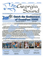
Catch the Excitement
of CoastFest 2006!
Saturday, October 7
10am-4pm
Get ready coastal Georgia - the 11th Annual CoastFest celebration is almost here! CoastFest 2006 takes place on Saturday, October 7 from 10am-4pm at the Department of Natural Resources Coastal Regional Headquarters along the Marshes of Glynn in Brunswick.
CoastFest is Georgia's largest celebration of our coastal natural resources and attracts between 6,000 - 7,000 excited visitors annually. This FREE family-oriented event features over 85 interactive exhibitors and activity areas where festival goers can "do" and "see" and "touch" as they learn about our natural surroundings.
Bring a camera for the many great photo opportunities around the festival, with costumed characters and with painted event photo boards. Get "up close and personal" with live native snakes and reptiles and meet live sea critters at the touch tank area. Climb aboard the Research Vessel ANNA and other water crafts and talk with the women and men who work on board these vessels daily. Become a "scientist for a day" by conducting a multitude of experiments. Watch one of the three rotating programs "under the big tent" scheduled throughout the day. Create "make it take it" crafts and projects and keep your handiwork! View the hundreds of CoastFest student art contest entries. Travel back in time and take part in living history demonstrations. Purchase and wear one of the much-sought-after CoastFest event T-shirts. Grab a bite to eat at one of three CoastFest non-profit food booths. Visit a Creek Indian Encampment. And much much more!
CoastFest has a "little something for everyone" no matter your age! On October 7 come learn and have fun at the same time at CoastFest 2006. The EXCITEMENT is catching and it is at CoastFest!
For more information or to download an event flyer log onto http://crd.dnr.state.ga.us or call Lea King at (912) 264-7218.
Inside This Issue:
CoastFest 2006!
Sea Monkeys Help Community
KNOW the CONNECTION
Beach Week Success
LID for Your Neighborhood
ESRI Grant Aids CRD Gray's Reef Update
Ship to Shore
Boating Safety
Spotlight on Beach Water Quality Data
PAGE 2
THE GEORGIA SOUND
S U M M E R , 2 0 0 6
By: Lea King ~ Public Affairs Coordinatort
Sea Monkeys Take Action & Help Community
The Glynn County 4-H Sea Monkeys have not
rested on their laurels of late. During their
internationally and nationally awarding winning
"Orange Tide Study" last year, the Sea Monkeys
took note of the large amount of dog waste left on
the beaches of St. Simons. In one two-hour effort,
the group picked up over eight pounds of dog
waste on the beach between the old Coast Guard
Station entrance and Gould's Inlet. This spurred
Members and community supporters of the Glynn County Senior 4-H Club (Sea Monkeys) celebrate the unveiling of their new pet waste dispensers on St. Simons Island beaches.
the Sea Monkeys into action. The group saw a need for more pet waste bag dispensers at various points on the beaches and decided to create their
own model. They worked on several different designs of possible "poop bag dispensers" and finally
settled on one.
Sea Monkey Will Prince and his father, Jack, came up with the final design. They utilized previously-used plastic water cooler jugs donated by Crystal Springs, DS Water Co., and with the addition of strategically cut holes and PVC pipe, constructed community friendly dispensers. The painted white jugs were turned upside down and a slot created near the "top" for the insertion of plastic grocery bags. At the new "bottom" of the unit three holes were made for the public to access the grocery bags. The Sea Monkey 4-H members solicited donations of needed materials and constructed 25 units. The units are designed to be "self supporting" with community members helping to fill the units using their recycled grocery bags. The bags are handy for dog waste removal, picking up litter or collecting sea shells.
Glynn County staff has installed several of the units at St. Simons Island beach access sites including Massengale Park and the old Coast Guard Station entrance. The club received guidance and support from the Brunswick Golden Isles Convention & Visitors Bureau, Keep Brunswick-Golden Isles Beautiful and DNR Coastal Resources Division. For more information on the dispensers and/or the project, contact Glynn County 4-H leader Robi Gray at 912-554-7575. Community members are encouraged to help keep the dispensers stocked by depositing previously "used" plastic grocery bags in the units.
TRASH
Community members are encouraged to help refill the dispensers with plastic grocery
bags.
THE GEORGIA COASTAL
M A N A G E M E N T
P R O G R A M
S U M M E R , 2 0 0 6
THE GEORGIA SOUND
PAGE 3
By: Lea King ~ Public Affairs Coordinator
KNOW CRD Launches "Know the Connection"
THE CONNECTION
COASTAL GEORGIA
Educational Campaign
GA DNR Coastal Resources Division www.KnowTheConnection.com
CRD has launched a new educational campaign, "Know the Connection." Know the Connection focuses on the numerous ways that humans and the natural world interact, both positively and negatively, within the coastal zone. Our goal is to increase public awareness of the social, ecological, and economic value of
Georgia's natural resources.
We as individuals and communities affect the natural world around us through our CONNECTIONS. Coastal Georgia visitors, residents and up-stream neighbors share a unique CONNECTION to this natural environment.
These CONNECTIONS are limitless.
DNR's Coastal Resources Division associates are working with and studying these CONNECTIONS and want to help you KNOW THE CONNECTION. We have launched a new educational campaign, KNOW THE CONNECTION in an effort to better convey information concerning our coastal natural world. Take a journey with us through our coastal world and discover many of the CONNECTIONS that exist, why they are important and the role we all play within our environment in coastal Georgia
We invite you to KNOW THE CONNECTION.
Log on to www.KnowTheConnection.com to learn more about this educational endeavor.
The DNR Coastal Regional Headquarters building in Brunswick sports a Know the Connection banner.
Get your Know the Connection BUMPER STICKER today!
The new Know the Connection web site will be unveiled at CoastFest on October 7 and will be a comprehensive and exciting educational site. Housing educational materials (the CRD site will still house its same information), the Know site will highlight the many CONNECTIONS that exist within the coastal natural world and will offer a multitude of educational and informational materials.
Newly developed fact sheets are currently available at the CRD offices (and will be available on the web site) and focus on a wide variety of coastal natural resource topics including waves, tides, shells, fiddler crabs, and many more.
Know the Connection bumper stickers are HERE and are FREE! The KNOW stickers can already be seen on the back windows and bumpers of coastal Georgia automobiles - don't be left out - get yours today! Stop by the DNR Coastal Regional Offices in Brunswick or call/email Lea King at (912) 264-7218 or lea_king@dnr.state.ga.us to have a sticker mailed to you.
Know the Connection bumper stickers are here! Get yours today!
THE GEORGIA COASTAL
M A N A G E M E N T
P R O G R A M
PAGE 4
THE GEORGIA SOUND
S U M M E R , 2 0 0 6
By: Jennifer Kline ~ Coastal Technical Assistant
1st Annual Beach Week a Success
Beach Week provided a great opportunity for participating organizations to interact with beach-goers and to provide then with
interesting and pertinent beach information.
When summer is in full swing many thoughts and plans in the Golden Isles center around Georgia's beaches. Tourists and even local beach-goers visiting Georgia's barrier island beaches are sometimes unaware of the many amazing things that can be seen during beach outings. With this need for knowledge, the Coastal Ark, along with staff from the UGA Tidelands Nature Center, Georgia Sea Turtle Center and Gray's Reef National Marine Sanctuary, took on the challenge of educating the beach-going public with the "First Annual Beach Week."
Held July 5-7, the Beach Week educational endeavor visited the beaches of both St. Simons and Jekyll Islands. Participating organizations provided educational displays and information focusing on beach and marine life and beach water quality. Staff members answered questions and expanded understanding of beach components. During the three days approximately 1,000 beach-goers stopped by the Ark during, before and after their beach excursions.
Beach Week's goal was to educate both tourists and locals about what they would see at the beach and why good stewardship of this resource is so important. Event success was easily measured in the excitement of beach-goers as they recognized shells or crabs listed on the "beachcomber guide" and in the action of children taking live sand dollars back to the ocean upon learning they were living creatures. With the success of Beach Week, Coastal Resources Division plans to continue the event annually and to include additional Georgia beaches in the future.
Learning about our coastal environment was all part of the Beach Week fun.
THE GEORGIA
A traveling educational road show of sorts, Beach Week offered beach visitors an opportunity to ask questions of local biologists and learn with "hands-on" activities.
C O A S T A L
M A N A G E M E N T
P R O G R A M
S U M M E R , 2 0 0 6
THE GEORGIA SOUND
PAGE 5
By: Jennifer Kline ~ Coastal Technical Assistant
Low Impact Development for Your Neighborhood,
Your Community and Your Coast
Low Impact Development, or LID, is an array of site planning, design and pollution prevention strategies that, when used in combination, create an economically and ecologically sustainable and functional landscape. LID in practice uses a "decentralized at the source" approach to control stormwater runoff by preserving or mimicking natural hydrological and water quality functions throughout a development.
LID is one tool in the suite of smart or quality growth strategies that focuses specifically on stormwater management, but, when implemented, LID often achieves a variety of quality growth goals. However, LID's utility and design requirements are often misunderstood by local governments, engineers/site planners, and developers. This is because many LID techniques are "non-structural" meaning that they do not always involve the use of pipes or concrete detention ponds to manage stormwater. Instead they include landscape features such as rain gardens and swales, or other features like rain barrels and pervious paving. Many local government ordinances are not equipped to address non-structural stormwater techniques, and engineers and developers are, therefore, hesitant to use them.
As a means to bridge this gap between LID, local ordinances, and the concerns of engineers and developers, the Georgia Coastal Management Program (GCMP) co-sponsored the "Saving Money Through Smart Development 2006: A Low Impact Development Seminar Series." This series was hosted in partnership with the Bryan County Tree Foundation, Sapelo Island National Estuarine Research Reserve/Coastal Training Program and University of Georgia/Coastal Georgia NEMO Program.
The first seminar, held in Richmond Hill on July 19, targeted local governments, planners, and developers from Bryan County in particular. They presented the basic concepts of LID and the important role local governments and regulations play in the planning and approval process. The seminar also presented an "audit" of one set of local ordinances and recommended where improvements could be made to facilitate LID in that community. The second seminar, held in Brunswick on July 20, targeted coastal developers, engineers, land planners, and landscape architects. The purpose of this seminar was to present the technical engineering, design, and maintenance considerations of LID in practice, and to demonstrate LID as a feasible alternative to traditional stormwater design. Both workshops discussed economic considerations of LID, as well as regulatory challenges and other road blocks. All participants toured the GCM's Coastal Ark to see how it may be used to bring resources management concepts to local governments and other organizations.
The GCMP Technical Assistance initiative hopes to use information learned during the seminars to work with local governments on addressing regulatory challenges, and with the coastal development community to help facilitate use of LID designs throughout coastal Georgia. For more information about Low Impact Development, please contact Jennifer Kline, Coastal Ark Coordinator at Jennifer_kline@dnr.state.ga.us. or (912) 262-3049.
The Georgia Coastal Management Program's Technical Assistance component uses many platforms such as Georgia's Coastal Ark to bring
resource management concepts to local governments and other organizations.
THE GEORGIA COASTAL
M A N A G E M E N T
P R O G R A M
PAGE 6
THE GEORGIA SOUND
S U M M E R , 2 0 0 6
By: Buck Bennett ~ Monitoring, Compliance, & Enforcement Program Manager
ESRI Grant Aids Coastal Resources Division
The Georgia Department of Natural Resources (DNR) has been struggling with abandoned and derelict vessels for several years. Based upon recent estimates, there are approximately 62 abandoned or derelict vessels on the State's tidal water bottoms. These vessels include shrimp boats, abandoned recreational vessels, barges, and cranes.
Lodged on the beach at Little St. Simons Island, this tugboat is just one of many derelict and abandoned vessels located throughout coastal Georgia.
In most cases there is no insurance coverage nor does the owner have the appropriate financial ability to retrieve the vessel. In other instances the owners of the sunken vessels cannot be found or ownership cannot be proven. Most boat owners escape financial responsibility through either bankruptcy laws or a clause in Federal maritime law that limits an owner's liability to the value of the ship and its contents. Since most abandoned vessels are valueless, the owner's liability is usually zero.
During the 2006 legislative session, $180,000 was appropriated to remove some of these derelict vessels. A team of DNR Coastal Resources (CRD), Environmental Protection and Law Enforcement personnel has been formed to catalog, evaluate, and prioritize the vessels for removal. To assist in the documentation and location of these non-historic derelict vessels, Buck Bennett, CRD Monitoring, Compliance, and Enforcement Program Manager and Jill Andrews, Acting CRD Operations Program Manager applied for a grant through ESRI. The ESRI and Trimble Mobile Government Grant Program was established with two goals in mind. The first objective is to establish a vehicle to provide assistance to state, regional, and local government agencies in establishing models that demonstrate concepts related to the development and implementation of innovative GIS and GPS applications aimed at improving government processes. The second objective is to provide reusable applications that can be shared between governments with similar projects via ESRI's public domain web site.
CRD will receive hardware and software to more accurately document the location of these derelict vessels. Staff will traverse the waterways where the vessels are believed to be located to find and collect GPS data for each site. Additional information, such as impact to marsh vegetation from the vessel itself or from fuel and oil leaks will be collected as well. This information will be analyzed using GIS software and staff will have the necessary information to make decisions regarding the removal of these derelict non-historic wrecks. The secondary objective of this project is to better serve the boating public by informing them of these coastal hazards in order to minimize the risk of collision and injury. Non-historic derelict vessel listings will be maintained and posted on the CRD website at http://crd.dnr.state.ga.us.
If you have questions or comments regarding the location of non-historic sunken or derelict vessels in coastal Georgia tidal waters please contact Buck Bennett at (912) 264-7218 or via email at buck_bennett@dnr.state.ga.us.
THE GEORGIA COASTAL
M A N A G E M E N T
P R O G R A M
S U M M E R , 2 0 0 6
THE GEORGIA SOUND
PAGE 7
By: Gail Krueger ~ Gray's Reef National Marine Sanctuary Outreach Coordinator
Gray's Reef Update
Many coastal residents attended one or more of the 15 public meetings on the Gray's Reef National Marine Sanctuary (GRNMS) Draft Management plan. We received over 2,000 comments about the draft and now the Final Plan is ready and we'd like to give you the basics of the changes.
There are two big regulatory changes in the plan--prohibiting anchoring in the sanctuary and revising regulations to allow fishing only with rod and reel, handline, and spearfishing gear without powerheads. The regulations apply to all users of the sanctuary.
Gray's Reef National Marine Sanctuary is one of the largest near shore live-bottom reefs in the southeastern United States.
Located 17.5 nautical miles off Sapelo Island, Georgia, it is one of 13 marine sanctuaries that make up the National Marine Sanctuary System.
Prohibiting anchoring at GRNMS (except, of course, during an emergency where life or property is at risk) will eliminate physical damage to the reef caused by anchoring. Keeping the bottom habitat intact is important because it is the habitat that attracts the bait fish (and invertebrates) and the bait fish attract the pelagic fish.
Switching to an allowable gear regulation will simplify things for both anglers and law enforcement officials. Now, we will simply just list the gear that is allowed to be used for fishing in Gray's. That gear is "the use of rod and reel, handline, and spearfishing gear without powerheads."
In addition, to keep things simple, we will not impose a limit on the number of hooks which can be attached to a single line that is attached to the "allowable gear." As long as the gear is allowable as defined by the Final Management Plan, there is no hook number limit.
Spearfishing with powerheads continues to be against our regulations. For the next two years, we will continue to allow spearfishing without powerheads. During those two years, we will gather additional information about this activity within the sanctuary. We hope that if you have the opportunity to participate in a survey about your activities at Gray's Reef that you do so.
There is no proposal in this Final Management Plan to close Gray's Reef. However, the Final Plan does include a nonregulatory action to consider the concept of a Marine Research Area.
A working group of the sanctuary's Advisory Council found that significant research questions exist at Gray's Reef that can only be answered by establishing a control (research) area. That concept, the Council decided, should be further explored through a public decision-making process. If established, the research area would be a smaller area within the existing boundaries.
The Advisory Council unanimously endorsed and enhanced the recommendations. NOAA GRNMS accepted the Council recommendations and will formally consider the concept of a research area in the sanctuary through a public process.
In order for such an area to be established at Gray's Reef, an entirely separate public process will have to take place. The process will include scoping meetings, workshops, public presentations and a variety of other ways for the public to express opinion. Again, we invite you to fully participate in the process.
We hope that this information helps to inform our users of the changes in the management plan and we encourage you to download a copy of the plan at www.graysreef.noaa.gov.
Gray's Reef includes both rocky ledges and sandy flat places. The rock ledges, submerged beneath 60 to 70 feet of water, can be as tall as 6-8 feet. Highly complex, they have nooks and crannies and bumps and plenty of places
for invertebrates to latch on to and for fish to hide.
THE GEORGIA COASTAL
M A N A G E M E N T
P R O G R A M
PAGE 8
THE GEORGIA SOUND
SU MMER,2006
Susan Shipman
From the Director's Desk
SHIP TO SHORE... Coastal Resources Division Director
Addressing Coastal Development
There have been many activities underway this past spring and summer within the Department and the Coastal Resources Division (CRD) to address coastal development and protection of coastal resources. Our efforts have involved technical assistance as well as regulatory approaches.
Georgia's Coastal Management Program contracted with UGA's River Basin Center to produce a model coastal riparian buffer ordinance, which was recently completed. This model ordinance provides guidance to local governments for establishing riparian buffer zones as well as recommended requirements for minimizing development within those buffers, to stabilize stream banks, prevent sedimentation, and protect water quality for aquatic resources. A model ordinance specific for the City of Tybee Island was also developed as a companion project.
An activity generating considerable interest not only along the coast but statewide is the Coastal Uplands Stakeholders Process. This spring the Board of Natural Resources tasked the Department with undertaking a stakeholders process to the examine stormwater management measures, impervious surface coverage and buffer design and maintenance, for waterfront developments subject to permitting under the Marsh Act. The goal is to explore regulatory possibilities into the future, to bring much needed clarity for the Coastal Marshlands Protection Committee as well as to look at the broader topic of comprehensive stormwater management on the coast.
The Coastal Uplands Stakeholders Process is being facilitated by UGA's Fanning Institute. The Department has brought many diverse interests to the table. The core of the stakeholders group is a broadly representative Marinas and Community Docks stakeholders group formed last year by the Coastal Marshlands Protection Committee to develop recommended standards for permitting of marinas and community docks. The Department has appointed additional members with knowledge, expertise, and experience, and/or vested interests in stormwater management, impervious cover, and buffers. Because the process entails a broad look at the Department's authorities, this initiative has involved the Commissioner's office, DNR Environmental Protection Division and CRD.
The group met throughout the summer. At the time of this writing, their report is being finalized for presentation to the DNR Board in early September. Proposals receiving broad consensus will be brought to the Board as stakeholder recommendations, but they will also be briefed on additional issues as well. Some of these may be proposed measures for Rulemaking through the Marsh Act; others may be recommendations for implementation through other authorities.
The Board of Natural Resources will make the decision about what goes forward for rulemaking. In mid to late October the stakeholders will reconvene to receive the Board's feedback and refine their recommendations as appropriate. The Board would be briefed on any proposed regulatory changes in December, with final action scheduled for late January. There will be opportunity for public input as any proposals advance.
There is a Quick Link on CRD's home page established for the Coastal Uplands Stakeholders Process. It contains the stakeholders roster, summaries of the meetings, technical information provided to the stakeholders, and review a strawman document that has serving as a springboard for the group's discussion.
Despite the difficulty and complexity associated with the many diverse interests around the table, most if not everyone participating in the stakeholders dialogue agrees that effective stormwater management is crucial for the coastal region. However, opinions are quite divergent as to the best mechanisms for accomplishing that goal. The Department views the Coastal Uplands Stakeholders Process as an initial step to derive a solution across jurisdictional lines. The Department sincerely appreciates the time, energy, and thoughtful deliberation that the Coastal Upland Stakeholders have dedicated to improving stormwater management for Georgia's coast.
THE GEORGIA COASTAL
M A N A G E M E N T
P R O G R A M
S U M M E R , 2 0 0 6
THE GEORGIA SOUND
PAGE 9
A SAFE BOAT
Boating Safety
By: CRD Staff
Trailer Launching Boats
Georgia's coastal creeks and rivers consist primarily of mud and sand bottoms. With the current velocities produced by daily tides ranging from 6 to 8 feet, this type of substrate often gives way to erosion problems which may create a steep drop-off at the foot of many boat ramps. Therefore, boaters should take caution when launching boats during low tide periods to insure that adequate ramp surface extends out far enough to safely back trailers when launching boats.
Personal Flotation Devices (PFDs)
Personal flotation devices (PFDs) are an important safety item and are required to be readily accessible - NOT just stored aboard all boats. PFDs, one wearable for each passenger, are required on all boats. Regulations may differ among states so be sure to check state requirements.
There are several types of PFDs including: 1. Life Preservers (Type I) are designed in such a way that, even if injured or unconscious, the wearer's face remains out of the water. Type I is the most effective for long exposure in rough water. 2. Buoyant Vests (Type II) are designed to turn an unconscious person face up or slightly backward in the water. 3. Special Purpose Devices (Type III) are designed so a conscious person can float in a vertical or slightly backward position and keep their head above water. However, the Type III PFD has little or no turning ability and may not turn an unconscious person upright in the water. 4. Throwable Devices (Type IV) are designed to throw to people in the water. Type IV PFDs do not give the same protection available from a wearable type device. 5. Restricted Special Purpose Device (Type V) is any PFD approved by the U.S. Coast Guard for restricted use on vessels used for a specific activity such as canoeing, rafting, kayaking, sail boarding, or for commercial uses. Typically an inflatable, wearable device.
U.S. Coast Guard Regulations for PFDs 1. Boats sixteen (16) feet or over in length must be equipped with one Type I, II, or III (Wearable PFD) for each person on board or being towed on water skis, plus one Type IV (Throwable) in case someone falls overboard. 2. Boats less than sixteen (16) feet in length, and all canoes and kayaks, must be equipped with one Type I, II, or III PFD for each person on board or being towed on water skis, etc. 3. A Type V PFD may be carried in lieu of any PFD, but only if the Type V PFD is worn while the boat is being used. The PFD must be a U.S. Coast Guard approved inflatable, wearable device.
Any person being towed on water skis, aquaplane, surfboard or any similar device is required to wear a ski belt, ski jacket, or a Type I, II, or III U.S. Coast Guard approved personal floatation device. A ski belt will not count as one of the PFDs for the boat.
Fire Extinguisher
Fire on a boat is one of the skipper's greatest fears and one of the major causes of damage to boats. For protection all boats should carry fire extinguishers approved by the U.S. Coast Guard. Fire extinguishers must be readily accessible, and must at all times be kept in condition for immediate and effective use.
Fire extinguishers are classified by letters and numbers according to the type and size fire they can put out. The letter indicates the type of fire: "A" for combustible solids like wood; "B" for flammable liquids; and "C" for electrical fires. The following fire extinguishing materials can be used to put out various types of fire on boats:
Fire Extinguisher Type Carbon Dioxide (CO2) Halon/Freon Dry Chemical Foam Water
Type Fire (A,B,C) (A,B,C) (B,C) (B) (A)
~ Continued on Page 10 ~
THE GEORGIA COASTAL
M A N A G E M E N T
P R O G R A M
PAGE 10
THE GEORGIA SOUND
S U M M E R , 2 0 0 6
~ Continued from Page 9 ~
Some boat fires involve burning wood and paper and can be put out with water. Do not use water on gasoline, oil, or electrical fires! Water will cause a gasoline or oil fire to spread or cause an electrical shock. Adequate fire extinguishers must be aboard vessels mechanically-propelled according to the size-class of the vessel. In Georgia, the fire extinguisher requirements for each boat size-class are as follows:
Boat Class A 1 2
Boat Length (ft) Less than 16 16 to 26 26 to 40 40 or more
When No Fixed Fire Extinguisher System In Engine Space One B-I One B-I Two B-I or one B-II Three B-I or one B-I
and one B-II
When a Fixed Fire Extinguisher System Installed In Engine Space None None One B-I Two B-I or one B-II
EXTINGUISHER FOAM (Type-Size)
B-I B-II
DIOXIDE (Min Gals) 1 1/4 2 1/2
CARBON CHEMICAL (Min Pounds)
4 15
DRY FREON (Min Pounds)
2 10
(Min Pounds) 2 1/2
Open runabouts of Class "A" and Class "1" shall not be required to be equipped with fire extinguishers provided the construction of such vessel will not permit the entrapment of explosive or flammable gases or vapors.
Extinguishers should never be tried merely to see if they are in proper operating condition because in many cases the valves may not properly reseal, resulting in a gradual discharge of the extinguishing agent. After using an extinguisher, recharge it as soon as possible and before using the boat again.
Ventilation
Regulations require ventilation of all closed engine and fuel tank compartments if gasoline is used for fuel. Exhaust blowers are installed in engine compartments so that gasoline fumes can be removed before engines are started. Gasoline vapors can explode if engines are started before blowers are allowed to operate for four (4) minutes to remove fumes.
Whistles and Horns
All boats should carry some type of sound-producing equipment for signaling. Sound-producing equipment may be needed for emergencies, fog or heavy rain conditions, or maneuvering in heavy boat traffic. In Georgia, every boat 26 feet in length or longer must be equipped with a whistle, horn or other sound-producing mechanical appliance capable of producing sounds which would warn approaching vessels of your presence.
Lights
Any boat used between sunset and sunrise must show the lights required by law. Failure to show necessary lights is one of the leading causes of fatal accidents in Georgia. Remember, the motor noise of your vessel makes it almost impossible to hear a vessel approaching, and lights are the only way to locate a moving vessel during hours of darkness. Even though you may not plan to use your boat after sunset, you should have the required lights installed for your protection. Lighting requirements will vary according to boat size and design.
Mirrors
All boats used for towing persons on skis, aquaplanes, surfboards, or similar devices are required to be equipped with a wide angle mirror or else have a person, other than the operator, who is competent, to constantly observe the person being towed.
ALCOHOL ON BOARD
For many people, beer is the boat's most important cargo. Depending on the amount consumed, alcohol can add to the day's enjoyment or be the cause of a tragedy. It is everyone's responsibility to control on-board drinking. The easiest way to avoid excessive drinking is to limit the amount of alcohol you bring on board.
~ Continued on Page 11 ~
THE GEORGIA COASTAL
M A N A G E M E N T
P R O G R A M
S U M M E R , 2 0 0 6
THE GEORGIA SOUND
PAGE 11
~ Continued from Page 10 ~
Drinking, combined with fatigue due to glare and constant boat motion, causes accidents. Alcohol affects balance and muscle coordination and causes tunnel vision and inability to track moving objects. Excessive drinking slows reaction time, increases the tendency to take risks, and affects reasoning. People who've had too much to drink lose the ability to judge the effects of alcohol. Any behavior that is unusal for a particular passenger is a danger sign (e.g. loud talking, slurred speech, clumsy behavior, dropping or spilling things, etc.). Help insure a safe and enjoyable boating trip by limiting the drinking of any person on board who shows these signs.
WHAT TO DO IN CASE OF AN ACCIDENT
The Georgia Boat Safety Act requires the operators of all vessels involved in accidents to render such assistance as may be practical and necessary, insofar as can be done without serious danger to their own vessel, crew and passengers.
Operators of vessels involved in accidents are also required to give their name, address, and identification of their vessel in writing to any person injured and to the owner of any property damaged.
Persons who render the aid required by law, and who gratuitously and in good faith render assistance at the scene of a vessel accident may not be held liable for any civil damages as a result of the rendering of assistance, as long as such assistance is rendered in a prudent manner.
A reportable boating accident is any accident which results in loss of life or disappearance, injury sufficient to require first aid or medical attention, or damage to vessels or other property in excess of $2,000.
SURVIVAL IN THE WATER
You may fall overboard or be forced into the water from a boating accident. Don't panic or fight the water. Swim slowly and easily to conserve strength. Hang onto the boat unless it is in danger.
Any item that floats will help keep you afloat. In a fire or explosion, throw anything that floats overboard. Tie a rope to the floating gear to hold on to. If the boat is on fire you can then float a safe distance away and not lose the boat. Floating debris is easier to see than one person in the water.
Clothing can preserve body heat and help you float. Take it off only if it hampers movement. Fasten clothing around your neck to trap air. Keep your arms under water. If wearing trousers, bend your legs to hold the air in around your knees. Fishermen can use the air which is trapped in their boots to keep them afloat.
You may begin to loose body heat through hypothermia. Don't discard clothing if water is cold, clothing helps trap the body's heat. Thrashing around in cold water only leads to exhaustion and swirling water takes heat from the body more rapidly than still water. If several people are in the water, huddle closely together or if alone, fold your legs to your chest and remain as still as possible. If you are exhausted or losing consciousness, tie yourself to anything that floats.
RUNNING AGROUND
Tide levels in Georgia typically range as high as 8 feet. Such changes in water level increase the chance of running aground. As in all emergency situations the first thing to do is keep calm. Usually, the first impulse is to shift immediately into reverse, gun the engine, and attempt to back up. This could be the wrong move. The propeller spinning in reverse may pull more sand and mud under the keel making matters worse. Also, continued operation may clog the cooling system with sand or mud and cause your motor to overheat.
Instead, tilt up your motor. With an oar or paddle test the bottom all around the boat. If the bottom is shallow and sandy and it is safe to do so, get a couple of people out of the boat and push it off. You might get results by having your passengers move and shift their weight gently rocking the boat while it is being pushed. Remember, with 6 to 8 foot tides, the water level may be rapidly falling and you may have only minutes to free your boat before it is totally grounded high and dry. For your boating safety, it is highly recommended that you obtain a navigational chart and study your boating area. Many coastal marinas sell navigational charts or can tell you where to purchase one. Log on to http://georgiawildlife.dnr.state.ga.us/ for more boating safety information.
THE GEORGIA COASTAL
M A N A G E M E N T
P R O G R A M
PAGE 12
THE GEORGIA SOUND
T H E
G E O R G I A
C O A S T A L
M A N A G E M E N T
P R O G R A M
Georgia
Sound
J U L Y - S E P T E M B E R , 2 0 0 6
VOL.12, NO.3
Department of Natural Resources
Coastal Resources Division One Conservation Way, Suite 300 Brunswick, GA 31520-8687
KNOW
THE CONNECTION
COASTAL GEORGIA
Don't forget - the GA Sound is on the web! Log on to the CRD web site http://crd.dnr.state.ga.us
& look under "Education & Outreach" to find the current and archived pdf versions of the Sound.
S U M M E R , 2 0 0 6
Spotlight on Beach Water Quality Data Where does it go? Who Uses the Data?
Every week, we collect water samples on the beaches of Jekyll, St. Simons, and Tybee island. This water is sent to the laboratory for bacterial analysis. For each water sample, the number of bacterial colonies is calculated and entered into a database. When the bacterial count rises above the threshold level, we notify the Health Department and they issue a swimmers advisory for the affected beach. This is how the data is of immediate benefit to the public. There are other, long-term benefits to this data. We send Georgia's beach data to the federal Environmental Protection Agency nationwide water quality database. The data is publicly available and can be downloaded for use in environmental studies and reports.
One group that uses the data is the National Resources Defense Council (NRDC), a non-governmental environmental group. The NRDC analyzes and summarizes the beach data from all coastal states and prepares an annual "State of the Beach" report. The report is intended for the general public and provides a look at national and state trends in beach water quality. NRDC also names its annual Beach Buddies. These are jurisdictions that NRDC finds monitor beachwater quality regularly, close beaches or notify the public when at least one of EPA's health standards is exceeded, and take Significant steps to reduce pollution. This year, two Tybee Island beaches were Designated as a "Beach Buddy."
Peach on the Beach
The Georgia Sound is produced quarterly by the Georgia Coastal Management Program. If you would like more information on the Georgia
Coastal Management Program, visit our web site at http://crd.dnr.state.ga.us
or contact Coastal Resources Division at (912) 264-7218. Past issues of The Georgia Sound can be found on the CRD web site.
Layout & Design by: Lea King For address corrections or to be added or deleted from the mailing list,
please contact Lea King at (912) 264-7218.
Lea_King@dnr.state.ga.us
Contributors to this issue: Buck Bennett, Elizabeth Cheney, Lea King, Jennifer Kline,
Gail Krueger and Susan Shipman
This publication is made possible through efforts by the Georgia Department of Natural Resources and the National Oceanic and Atmospheric Administration.
Deadline for the Fall 2006 edition is November 1, 2006. We welcome suggestions of articles and photography.