- No1
Military battles and campaigns


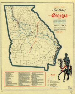
Maps dated between 1751 and 1968 showing campaigns of major military conflicts including troop movements, defensive structures and groundworks, roads to and from sites of military engagements, campsites, and local buildings, topography and vegetation.
More About This Collection
Date of Original
1751/1968
Subject
Georgia--Maps
Location
United States, Georgia, 32.75042, -83.50018
Medium
maps
Type
Still Image
Description
This category contains maps showing campaigns of major military conflicts including troop movements, defensive structures and groundworks, roads to and from sites of military engagements, campsites, and local buildings, topography and vegetation. Some of the maps are manuscripts drawn on the field of battle, while others are engraved including some that have manuscript annotations reflecting the history of the battle or campaign. A significant number of battle maps provide information about the locality that is not available elsewhere such as the location of plantations, the names of landowners in the area, the configuration of small towns and villages, and indications of prior settlement by native Americans.
Language
eng
Holding Institution
Library of Virginia
Library of Congress
Rights![]()